| APRSISCE/32
|
|
|
| Author:
|
Lynn Deffenbaugh KJ4ERJ
|
| License:
|
Proprietary (free of charge)
|
| Platforms:
|
Windows Mobile and Windows
|
| Version:
|
2012/08/29 (2012-08-29)
|
| Languages:
|
English and ...
|
| Website:
|
http://aprsisce.wikidot.com
|
|
Feature rich Amateur Radio Automatic Packet Reporting System client that uses OSM tiles as the base map.
|
|
Features
| Feature
|
Value
|
| Map Display
|
| Display map
|
yes
|
| Map data
|
raster
|
| Source
|
online;cache;offline
|
| Rotate map
|
no
|
| 3D view
|
no
|
| Shows website
|
?
|
| Shows phone number
|
?
|
| Shows operation hours
|
?
|
| Routing
|
| Routing
|
yes
|
| Create route manually
|
?
|
| Calculate route
|
no
|
| Create route via Waypoints
|
?
|
| Routing profiles
|
none
|
| Turn restrictions
|
no
|
| Calculate route without Internet (Offline routing)
|
no
|
| Routing providers
|
none
|
| Avoid traffic
|
?
|
| Traffic Provider
|
?
|
| Navigating
|
| Navigate
|
no
|
| Find location
|
no
|
| Find nearby POIs
|
no
|
| Navigate to point
|
no
|
| Navigation with voice / Voice guidance
|
no
|
| Keep on road
|
no
|
| Lane guidance
|
?
|
| Works without GPS
|
no
|
| Navigate along predefined route
|
yes
|
| Tracking
|
| Make track
|
yes
|
| Customizable log interval
|
yes
|
| Track formats
|
gpx
|
| Geotagging
|
no
|
| Fast POI buttons
|
yes
|
| Upload GPX to OSM
|
no
|
| Monitoring
|
| Monitoring
|
yes
|
| Show current track
|
yes
|
| Open existing track
|
yes
|
| Altitude diagram
|
no
|
| Show POD value
|
yes
|
| Satellite view
|
yes
|
| Show live NMEA data
|
yes
|
| Show speed
|
no
|
| Send current position
|
yes;APRS
|
| Editing
|
| Add POIs
|
no
|
| Edit / Delete POIs
|
no
|
| Add way
|
no
|
| Edit geometries
|
no
|
| Edit arbitrary tags of existing OSM objects
|
no
|
| Edit relations
|
no
|
| View notes
|
?
|
| Create notes
|
?
|
| Edit notes
|
?
|
| Work offline
|
none
|
| Support imagery offset DB
|
?
|
| Upload to OSM
|
no
|
| Rendering
|
| Renderer output formats
|
none
|
| Accessibility
|
| Accessibility support
|
?
|
| Complete non graphics text output
|
no
|
| Braille interface
|
no
|
| Exploration modus
|
no
|
| Public Transport mode
|
no
|
| Danger Warnings
|
no
|
| Screenreader
|
?
|
| Screenreader languages
|
?
|
|
|
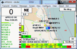
APRSISCE/32 (APRSISCE/32) is an Amateur Radio real time tactical display program written for the Windows Mobile and Windows operating systems by Lynn Deffenbaugh KJ4ERJ. The program makes use of prerendered OSM tiles as a background for tracking assets in real time. The program interfaces with a network of servers (APRS-IS) that carry a full world wide feed of data. This data is gathered from stations operating on the internet, the radio network, or a combination of both. Users on the radio network (RF) can operate completely detached from the internet, but a series on internet gateway stations (i-gates) are available to move data from RF to the internet and vice versa.
APRSISCE/32 can log location data which can be used to update the OSM GPS traces database, providing information back to the OSM community.
STATUS
APRSISCE/32 has been in active development since January 2009. You can download the application for your platform from (the wiki) once you have a copy running, downloads can be automatically performed from the ABOUT menu.