| AccessMap
|
|
|
| Author:
|
Taskar Center for Accessible Technology
|
| License:
|
(free of charge)
|
| Platform:
|
Web
|
| Status:
|
Active
|
| Version:
|
(2023-12-29)
|
| Language:
|
English
|
| Website:
|
https://www.accessmap.app
|
| Source code:
|
https://github.com/AccessMap
|
|
Accessibility-focused router available for a limited number of cities
|
|
Features
| Feature
|
Value
|
| Map Display
|
| Display map
|
yes
|
| Map data
|
?
|
| Source
|
?
|
| Rotate map
|
no
|
| 3D view
|
?
|
| Shows website
|
no
|
| Shows phone number
|
no
|
| Shows operation hours
|
no
|
| Routing
|
| Routing
|
yes
|
| Create route manually
|
?
|
| Calculate route
|
?
|
| Create route via Waypoints
|
?
|
| Routing profiles
|
foot;wheelchair
|
| Turn restrictions
|
?
|
| Calculate route without Internet (Offline routing)
|
?
|
| Routing providers
|
?
|
| Avoid traffic
|
?
|
| Traffic Provider
|
?
|
| Navigating
?
|
| Tracking
?
|
| Monitoring
?
|
| Editing
|
| Add POIs
|
no
|
| Edit / Delete POIs
|
no
|
| Add way
|
no
|
| Edit geometries
|
no
|
| Edit arbitrary tags of existing OSM objects
|
no
|
| Edit relations
|
no
|
| View notes
|
no
|
| Create notes
|
no
|
| Edit notes
|
no
|
| Work offline
|
?
|
| Support imagery offset DB
|
no
|
| Upload to OSM
|
?
|
| Rendering
?
|
| Accessibility
|
| Accessibility support
|
blind;wheelchair
|
| Complete non graphics text output
|
?
|
| Braille interface
|
?
|
| Exploration modus
|
?
|
| Public Transport mode
|
no
|
| Danger Warnings
|
?
|
| Screenreader
|
?
|
| Screenreader languages
|
?
|
|
|
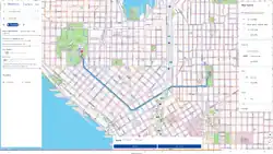
AccessMap provides detailed information on pedestrian paths, transit stations, elevation changes, curb ramps, and more to create an accessibility-focused router and navigation aide.
AccessMap is developed by the Taskar Center for Accessible Technology. More details about this project can be found here on the TCAT website.