BikeAtor
Author:
Andreas Wiener
License:
(free of charge)
Platforms:
Android, Openmoko Linux, and Symbian
Status:
Broken
Version:
0.2.1 (2017-01-23)
Language:
English
Website:
http://www.bikeator.de/ator (dead link)
Install:
Programming languages:
Python
Features
Feature
Value
Map Display
Display map
yes
Map data
raster
Source
online;cache;offline
Rotate map
yes
3D view
no
Shows website
?
Shows phone number
?
Shows operation hours
?
Routing
Routing
no
Create route manually
?
Calculate route
?
Create route via Waypoints
?
Routing profiles
?
Turn restrictions
?
Calculate route without Internet (Offline routing)
?
Routing providers
?
Avoid traffic
?
Traffic Provider
?
Navigating
Navigate
no
Find location
?
Find nearby POIs
?
Navigate to point
?
Navigation with voice / Voice guidance
?
Keep on road
?
Lane guidance
?
Works without GPS
?
Navigate along predefined route
?
Tracking
Make track
yes
Customizable log interval
?
Track formats
?
Geotagging
?
Fast POI buttons
?
Upload GPX to OSM
?
Monitoring
Monitoring
yes
Show current track
yes
Open existing track
yes
Altitude diagram
no
Show POD value
no
Satellite view
no
Show live NMEA data
no
Show speed
?
Send current position
?
Editing
?
Rendering
?
Accessibility
?
OSM Map on Nokia 5800 (Symbian S60 5th) There is also a version of BikeAtor for Symbian. It's very fast and stores images for offline use in a SQLite DB. It's called BikeAtorQt
OSM Map on Openmoko Freerunner You can get a Java (SWT) Version of BikeAtor
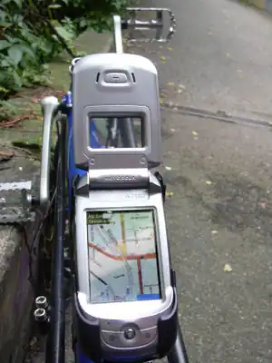
OSM Map on a Motorola A780 BikeAtor showing the OSM-map of Ludwigsburg, Germany Andreas Wiener wrote a little gpled Navigation Software called BikeAtor that turnes your beloved Linux-Smartphone to an ultimate OSM-tracker-tool! Fetch the OSM-map with BikeAtorDesktop , transform the data easily for the use with BikeAtor , turn on your A780 and walk down the streets that aren't shown on the display - BikeAtor can log it with a JOSM-compatible gpx-track.