Bing imagery analyzer for OSM
| Bing imagery analyzer for OSM | ||||||||||||||||||||||||||||||||||||
|---|---|---|---|---|---|---|---|---|---|---|---|---|---|---|---|---|---|---|---|---|---|---|---|---|---|---|---|---|---|---|---|---|---|---|---|---|
 | ||||||||||||||||||||||||||||||||||||
| Author: | Very Furry / Martijn van Exel | |||||||||||||||||||||||||||||||||||
| License: | undefined (but open) (free of charge) | |||||||||||||||||||||||||||||||||||
| Platform: | Web | |||||||||||||||||||||||||||||||||||
| Status: | Broken | |||||||||||||||||||||||||||||||||||
| Version: | 0.8[1] (2010-12-24) | |||||||||||||||||||||||||||||||||||
| Language: | English
| |||||||||||||||||||||||||||||||||||
| Website: | http://mvexel.dev.openstreetmap.org/bing/ | |||||||||||||||||||||||||||||||||||
| Programming language: | PHP | |||||||||||||||||||||||||||||||||||
|
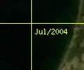
default bing satellite and aerial photos overlaid with their capture date as set in the HTTP headers for each tile |
||||||||||||||||||||||||||||||||||||
| ||||||||||||||||||||||||||||||||||||
The Bing Aerial Imagery Analyzer for OpenStreetMap was a site showing bing satellite and aerial photos overlaid with their capture date.
http://mvexel.dev.openstreetmap.org/bing/ As of September 2018[2] (or earlier?) the website is no longer working.
Read more about the tool: about.txt
It's a way of understanding Bing coverage, particularly in relation to age of images. See the Bing/Coverage page for other tools, in particular there is another tool showing coverage coloured in red, developed as a fork of this tool.
Development
The tool was developed by Martijn van Exel.
Code for this resource now resides on github. [3]
Notes
- ↑ Martijn van Exel. 14 October 2010. "(OSM-talk) new version of Bing aerial imagery analyzer tool".
- ↑ Discussion that the website is dead. 28 September 2018, on Twitter
- ↑ Martijn van Exel. 16 October 2010. "(OSM-Talk) new version of Bing aerial imagery analyzer tool".