Bonaire
Provinces: Noord-Brabant · Gelderland · Zuid-Holland · Noord-Holland · Zeeland · Utrecht · Fryslân · Overijssel · Groningen · Drenthe · Limburg · Flevoland
| V・T・E |
| latitude: 12.1689, longitude: -68.3082 |
| Browse map of Bonaire 12°10′08.04″ N, 68°18′29.52″ W |
| Edit map |

|
|
External links:
|
| Use this template for your locality |
Bonaire is a special municipality in The Netherlands, Caribbean, South America at latitude 12°10′08.04″ North, longitude 68°18′29.52″ West.
Aerial photos
Detailed aerial photo imagery of Bonaire, Sint Eustatius, and Saba is available from Dataroom Caribisch Nederland (with permission for use in OpenStreetMap).
Traffic rules
Bonaire
|
|---|
40 Binnen de bebouwde kom
|
60 Buiten de bebouwde kom
|
The boundaries of the built-up area are defined in the Besluit bebouwde kom, and indicated with blue rectangular traffic signs bebouwde kom and einde bebouwde kom below a speed limit sign.
-
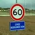 Traffic sign einde bebouwde kom
Central America
|
| México · Belize · Guatemala · Honduras · El Salvador · Nicaragua · Costa Rica · Panamá |
South America
|
| Brasil · Colombia · Venezuela · Ecuador · Perú · Bolivia · Paraguay · Chile · Argentina · Uruguay · Guyana · Suriname · Guyane française |
The Caribbean
|
| Cuba · Jamaica · Haiti · República Dominicana · Puerto Rico · British Virgin Islands · US Virgin Islands · Anguilla · Sint Maarten (NL) · St. Martin (FR) · St. Barthélemy · St. Eustatius · St. Kitts and Nevis · Antigua and Barbuda · Guadeloupe · Dominica · Martinique · St. Lucia · St. Vincent and the Grenadines · Barbados · Grenada · Trinidad and Tobago · · Curaçao · Aruba |
Iberian Peninsula
|
| España · Portugal |