Cs:Tag:tourism=information
 |
| Popis |
|---|
| Informace pro turisty a návštěvníky, včetně informačních kanceláří |
| Skupina: turistika |
| Použité na těchto prvcích |
| Vyžaduje |
| Vhodné kombinace |
|
| Status: de facto |
| Nástroje |
Informační zdroj pro turisty, cestovatele a návštěvníky. Může zahrnovat:
- Informační centra pro turisty a informační kanceláře.
- Cedule s mapami, jako mapy měst, areálů, turistické mapy a mapy tras jiných sportů.
- Informační cedule specificky pro turisty.
- Informační cedule s podrobnostmi o místní historii, přírodě, atd.
Jak mapovat
Přijdete uzel ![]() na střed prvku, nebo zakreslete plochu
na střed prvku, nebo zakreslete plochu ![]() budovy. Přidejte značku
budovy. Přidejte značku tourism= a značku information=* (viz níže). Jiné vhodné značky:
name=*- názevdescription=*- bližší popis
Hodnoty
Informace (Information)
| Klíč | Hodnota | Prvek | Popis | Vykreslování | Ilustrace |
|---|---|---|---|---|---|
| information | office | Informační centrum, kancelář podávající turistické informace o městu nebo oblasti. |  |
 | |
| information | visitor_centre | A place where you can get information about a specific attraction or place of interest. |  | ||
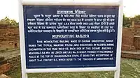
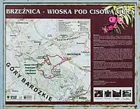
| information | board | Informační cedule. Můžete popsat její obsah značkou board_type=history/nature/....
|
 |
 | |
| information | stele | A stele for information. | 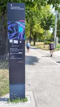 | ||
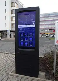
| information | terminal | Elektronický informační kiosek. Může být vybaven i přístupem k internetu (viz internet_access=*).
|
 |
 | |
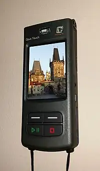
| information | audioguide | Místo, kde si můžete vypůjčit audioprůvodce, nebo se nechat vést svým mobilem. |  |
 | |
| information | map | Tabule s mapou. Další údaje o tom, co mapa zobrazuje můžete zadat značkami map_type=* a map_size=*. Viz information=map.
|
 |
 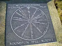 | |
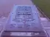
| information | tactile_map | Mapa okolí pro nevidomé, také známá jako haptická mapa. | |
 | |
| information | tactile_model | Model okolí pro nevidomé, např. okolních budov či krajiny. |  | ||
| information | guidepost | Rozcestník, obvykle stojící na turistických či cyklotrasách, ukazující směry na různé cíle. |  |
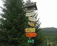 | |
| information | post | A small pole, erected vertically, with information on the top or sides that may be inscribed, or on a small plaque. Somewhat similar to an information=stele, but smaller. | .jpg) | ||
| information |
A marker that shows the position of the way of a route. Could be a symbol, a short pole or a painted marking. Note that two partially equivalent tag values are used: a more popular |
.jpg) 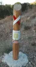 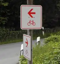 | |||
| information | další hodnoty | Další často používané hodnoty najdete pomocí Taginfo. |
This table is a wiki template with a default description in English. Editable here.