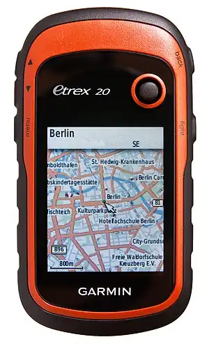
Garmin/eTrex 20
< Garmin
| Garmin eTrex® 20 | |||||
|---|---|---|---|---|---|
| Description | outdoor navigator (direction;routing) | ||||
| GNSS | 12 channels chipset: STA8088 TESEO II DOP: ? | ||||
| Memory | Internal: 1.7GB. External: ? microSD™ card. | ||||
| Host system | ? (operating system: ?) | ||||
| Display | 2.2" 65K color TFT | ||||
| Integrated equipment | USB cable | ||||
| Connectivity | usb | ||||
| Batteries | 2xAA | ||||
| Features |
| ||||
| Price | 199€ / $199.99 / £169.99 | ||||
| Website | official link Produktseite | ||||
| Notes |
discontinued | ||||
General description
Garmin eTrex 20 is a handheld GPS device. It has color display, supports loadable maps and runs on 2 AA batteries. eTrex 20 supports both GPS and GLONASS. It has 1.7GB built-in storage and accepts micro SDHC/XC cards at least up to 64GB.
| specification | despcription |
|---|---|
| Display | transflective, 65-K color TFT (176 x 220 pixels / 65K color) |
| Display size | 1.4" x 1.7" (3.5 x 4.4 cm); 2.2" diag (5.6 cm) |
| Interface | USB |
| Slot | microSD™ card |
| Dimensions (W x H x D) | 2.1" x 4.0" x 1.3" (5.4 x 10.3 x 3.3 cm) |
| Weight | 5 oz (141.7 g) with batteries |
| Battery | 2 x AA / 25 hours |
| Ships with | eTrex® 20, USB cable & Quickstart Guide |
| Misc | USB & GLONASS |
Traces and waypoints
The current trace is written to the internal file /Garmin/GPX/Current/Current.gpx. Saved traces and waypoints can be found in /Garmin/GPX/.
Firmware
The latest Firmware (4.20, as of January 21, 2015) can be found on Updates & Downloads.
Viewing and exporting data from device
You can use the Garmin Connect website to view your tracks on an OSM map.
Mac OS X
You can use BaseCamp for Mac to view and export data from your device.
Adding new maps
To add new maps to your eTrex 20 use Garmin.OpenStreetMap.nl.