| geoMapTool
|
|
|
| Author:
|
GeoThings
|
| License:
|
Proprietary (free of charge)
|
| Platforms:
|
Android and iOS
|
| Status:
|
Broken
|
| Version:
|
2.8.0 (2017-03-24)
|
| Language:
|
English
|
|
An editor that lets you draw and tag map features
|
|
Features
| Feature
|
Value
|
| Map Display
|
| Display map
|
yes
|
| Map data
|
raster;vector
|
| Source
|
online
|
| Rotate map
|
yes
|
| 3D view
|
no
|
| Shows website
|
?
|
| Shows phone number
|
?
|
| Shows operation hours
|
?
|
| Routing
|
| Routing
|
no
|
| Create route manually
|
?
|
| Calculate route
|
no
|
| Create route via Waypoints
|
no
|
| Routing profiles
|
?
|
| Turn restrictions
|
no
|
| Calculate route without Internet (Offline routing)
|
no
|
| Routing providers
|
?
|
| Avoid traffic
|
?
|
| Traffic Provider
|
?
|
| Navigating
|
| Navigate
|
no
|
| Find location
|
yes
|
| Find nearby POIs
|
yes
|
| Navigate to point
|
no
|
| Navigation with voice / Voice guidance
|
no
|
| Keep on road
|
no
|
| Lane guidance
|
?
|
| Works without GPS
|
no
|
| Navigate along predefined route
|
no
|
| Tracking
|
| Make track
|
no
|
| Customizable log interval
|
no
|
| Track formats
|
?
|
| Geotagging
|
?
|
| Fast POI buttons
|
no
|
| Upload GPX to OSM
|
no
|
| Monitoring
|
| Monitoring
|
no
|
| Show current track
|
no
|
| Open existing track
|
no
|
| Altitude diagram
|
no
|
| Show POD value
|
no
|
| Satellite view
|
no
|
| Show live NMEA data
|
no
|
| Show speed
|
no
|
| Send current position
|
no
|
| Editing
|
| Add POIs
|
yes
|
| Edit / Delete POIs
|
no
|
| Add way
|
yes
|
| Edit geometries
|
no
|
| Edit arbitrary tags of existing OSM objects
|
no
|
| Edit relations
|
no
|
| View notes
|
no
|
| Create notes
|
?
|
| Edit notes
|
no
|
| Work offline
|
online;cache
|
| Support imagery offset DB
|
no
|
| Upload to OSM
|
yes
|
| Rendering
?
|
| Accessibility
|
| Accessibility support
|
?
|
| Complete non graphics text output
|
no
|
| Braille interface
|
no
|
| Exploration modus
|
?
|
| Public Transport mode
|
no
|
| Danger Warnings
|
?
|
| Screenreader
|
?
|
| Screenreader languages
|
?
|
|
|
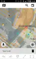
geoMapTool, also known as OSMViewer and GeoBingAn, is a mobile editor that is supposed to let you draw and tag POIs, lines, and areas.
The map itself shows Wikimedia Maps, OSM Carto, or DigitalGlobe. You position the map over a region and press the Download button to fetch the OSM data in the visible region. To draw a new line, you position the crosshairs over the start of the line, press the Line button, then repeat for each vertex. geoMapTool has built-in presets for common features. Pressing Finish Object immediately saves the changeset but doesn't close it, so you can continue to add to the changeset. All changesets are saved with the  Geothings Inc (on osm, edits, contrib, heatmap, chngset com.) account and are tagged with
 created_by=GeoThings Inc.
In recent versions you can log-in with your own OSM credentials.
The editor is limited to add new node/way/POI, not editing existing one.
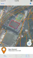
 Editing an element on Android