This page describes a historic artifact in the history of OpenStreetMap. It does not reflect the current situation, but instead documents the historical concepts, issues, or ideas.
About
a tool to make it dead simple to collect tracks and upload to Geobucket.org for tracing
Reason for being historic
The website is gone and the app is no longer maintained
Captured time
2012
This article or section may contain out-of-date information. The information may no longer be correct, or may no longer have relevance. If you know about the current state of affairs, please help keep everyone informed by updating this information. (Discussion)
Tool to make it dead simple to collect tracks and upload to Geobucket.org for tracing
Features
Feature
Value
Map Display
Display map
no
Map data
?
Source
?
Rotate map
?
3D view
?
Shows website
?
Shows phone number
?
Shows operation hours
?
Routing
Routing
no
Create route manually
?
Calculate route
no
Create route via Waypoints
?
Routing profiles
?
Turn restrictions
?
Calculate route without Internet (Offline routing)
?
Routing providers
?
Avoid traffic
?
Traffic Provider
?
Navigating
Navigate
no
Find location
?
Find nearby POIs
no
Navigate to point
?
Navigation with voice / Voice guidance
no
Keep on road
?
Lane guidance
?
Works without GPS
no
Navigate along predefined route
no
Tracking
Make track
yes
Customizable log interval
no
Track formats
?
Geotagging
?
Fast POI buttons
?
Upload GPX to OSM
yes
Monitoring
Monitoring
no
Show current track
no
Open existing track
no
Altitude diagram
no
Show POD value
no
Satellite view
no
Show live NMEA data
no
Show speed
?
Send current position
?
Editing
?
Rendering
?
Accessibility
?
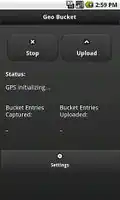
Geobucket (www.geobucket.org) tracks the longitude and latitude of a phone as it moves, allowing roads to be accurately mapped. This information is then uploaded to the Geo Bucket website where it can be used by volunteers to identify roads on for the OpenStreetMap project.
This application makes mapping completely non-intrusive for anyone who travels to unmapped places but does not want to be bothered by complex editing.
Geo Bucket runs on Android smart phones, but it also supports direct uploads of .GPX files.
Status
Geobucket is no longer actively maintained, with last development activity in 2012. The code is available on Github.