| GpsCycleComputer
|
|
|
| License:
|
BSD (free of charge)
|
| Platform:
|
Windows Mobile
|
| Version:
|
4.11 (2013-12-05)
|
| Language:
|
English
|
| Website:
|
http://code.google.com/p/gccv2/
|
|
sports, simple tracking
|
|
Features
| Feature
|
Value
|
| Map Display
|
| Display map
|
yes
|
| Map data
|
raster
|
| Source
|
online;cache
|
| Rotate map
|
no
|
| 3D view
|
no
|
| Shows website
|
?
|
| Shows phone number
|
?
|
| Shows operation hours
|
?
|
| Routing
|
| Routing
|
yes
|
| Create route manually
|
?
|
| Calculate route
|
?
|
| Create route via Waypoints
|
?
|
| Routing profiles
|
no
|
| Turn restrictions
|
no
|
| Calculate route without Internet (Offline routing)
|
?
|
| Routing providers
|
?
|
| Avoid traffic
|
?
|
| Traffic Provider
|
?
|
| Navigating
|
| Navigate
|
no
|
| Find location
|
no
|
| Find nearby POIs
|
no
|
| Navigate to point
|
no
|
| Navigation with voice / Voice guidance
|
no
|
| Keep on road
|
no
|
| Lane guidance
|
?
|
| Works without GPS
|
?
|
| Navigate along predefined route
|
?
|
| Tracking
|
| Make track
|
yes
|
| Customizable log interval
|
yes
|
| Track formats
|
?
|
| Geotagging
|
?
|
| Fast POI buttons
|
yes
|
| Upload GPX to OSM
|
no
|
| Monitoring
|
| Monitoring
|
yes
|
| Show current track
|
?
|
| Open existing track
|
?
|
| Altitude diagram
|
?
|
| Show POD value
|
?
|
| Satellite view
|
?
|
| Show live NMEA data
|
?
|
| Show speed
|
?
|
| Send current position
|
www
|
| Editing
?
|
| Rendering
?
|
| Accessibility
?
|
|
|
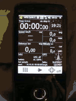
GpsCycleComputer (code.google.com/p/gccv2) is firstly a free GPS-Dashboard for Windows Mobile showing time, speed, distance in average and currend size
Additionally allows you to track routes, add waypoints, following imported traks and shows your speed and altitude in a diagram.
The collected data can be exported by one click to GPX or KML.
Optionally displays OpenStreetMap tiles (automatic downloaded or preloaded).
Also you can use different OSM-Maps (Osmarender,Mapnik... Cyclemap) by automatic downloading or preloaded into internal or external RAM. A separate directory is used for each zoom level.
You can also use a account from www.crossingways.com to upload the collected data automaticly.