| Engineering area
|
Road
|
Starting at
|
Via
|
Ending at
|
Length
|
%age complete
|
Checked by
|
Notes
|
| Kildare |
L-10009-0 |
L10009 serving Blackrath Cottages, The Curragh |
Ballymanny Interchange |
|
169.8000030518 |
|
|
|
| Clane |
L-10011-0 |
Junction R148 / L10011 at Ballynadrumny |
Royal Oak |
Junction with R160 / LP01001 at Calf Field |
1239.6700439453 |
|
|
|
| Maynooth |
L-10012-1 |
Temple Manor, Celbridge |
|
Temple Manor, Celbridge |
423.3999938965 |
|
|
|
| Maynooth |
L-10012-2 |
Temple Manor, Celbridge |
|
Temple Manor, Celbridge |
216.3999938965 |
|
|
|
| Maynooth |
L-10012-3 |
Temple Manor, Celbridge |
|
Temple Manor, Celbridge |
66.2099990845 |
|
|
|
| Maynooth |
L-10012-4 |
Temple Manor, Celbridge |
|
Temple Manor, Celbridge |
171.3999938965 |
|
|
|
| Maynooth |
L-10012-5 |
Temple Manor, Celbridge |
|
Temple Manor, Celbridge |
61.6300010681 |
|
|
|
| Maynooth |
L-10012-6 |
Temple Manor, Celbridge |
|
Temple Manor, Celbridge |
115.5999984741 |
|
|
|
| Maynooth |
L-10012-7 |
Temple Manor, Celbridge |
|
Temple Manor, Celbridge |
63.1599998474 |
|
|
|
| Maynooth |
L-10012-8 |
Temple Manor, Celbridge |
|
Temple Manor, Celbridge |
17.9699993134 |
|
|
|
| Maynooth |
L-10012-9 |
Temple Manor, Celbridge |
|
Temple Manor, Celbridge |
113.6999969482 |
|
|
|
| Maynooth |
L-10013-1 |
Celbridge Abbey |
|
Celbridge Abbey |
451.1000061035 |
|
|
|
| Maynooth |
L-10013-2 |
Celbridge Abbey |
|
Celbridge Abbey |
39.4199981689 |
|
|
|
| Maynooth |
L-10013-3 |
Celbridge Abbey |
|
Celbridge Abbey |
59.0200004578 |
|
|
|
| Maynooth |
L-10013-4 |
Celbridge Abbey |
|
Celbridge Abbey |
40.9099998474 |
|
|
|
| Maynooth |
L-10013-5 |
Celbridge Abbey |
|
Celbridge Abbey |
69.4199981689 |
|
|
|
| Maynooth |
L-10013-6 |
Celbridge Abbey |
|
Celbridge Abbey |
116.4000015259 |
|
|
|
| Maynooth |
L-10013-7 |
Celbridge Abbey |
|
Celbridge Abbey |
27.8099994659 |
|
|
|
| Maynooth |
L-10013-8 |
Celbridge Abbey |
|
Celbridge Abbey |
113.1999969482 |
|
|
|
| Maynooth |
L-10014-0 |
Junction L10014 - R148 Main Street Maynooth |
|
Junction Kelly's Lane L10014 - Pound Lane L10133, Maynooth |
73.0899963379 |
|
|
|
| Maynooth |
L-10015-1 |
Junction Of R148 Main Street Maynooth and Fagan's Lane L10015, Maynooth |
|
Junction Fagan's Lane L10015 - Pound Lane L10133, Maynooth |
71.4100036621 |
|
|
|
| Maynooth |
L-10016-1 |
Junction Coates's Lane L10016 - Main Street R148, Maynooth |
|
Junction Coate's Lane L10016 - Pound Lane L10133, Maynooth |
67.3199996948 |
|
|
|
| Maynooth |
L-10017-0 |
Junction Double Lane L10017 - Main street R148, Maynooth |
|
Junction Double Lane L10017 - Cross Lane L10018, Maynooth |
138.5 |
|
|
|
| Maynooth |
L-10018-1 |
Junction Double Lane L10017 - Cross Lane L10018, Maynooth |
|
Junction Cross Lane L10018 - Convent Lane L1013 Maynooth |
83.0800018311 |
|
|
|
| Naas Town Council |
L-10019-1 |
3 road junction with LS060521 / L50421 in Blessington |
|
Kildare / Wicklow county boundary |
318 |
|
|
|
| Naas Town Council |
L-10020-1 |
L2031 / L10020 junction at Newhall Crossroads |
|
Road serving KCC depot |
68.9400024414 |
|
|
|
| Clane |
L-10021-0 |
LP01002 / L10021 at Clonuff |
North east |
Cul-de-sac at Martin Flynn`s house in Clonuff |
756.8184814453 |
|
|
|
| Clane |
L-10023-0 |
Junction R408 / L10023 at Scrawtown, Curryhills, Prosperous |
|
Cul-de-sac serving houses at Scrawtown, Prosperous |
383.1000061035 |
|
|
|
| Naas Town Council |
L-10023-1 |
R445 / L10023 junction Naas |
West |
|
633.9000244141 |
|
|
|
| Naas |
L-10024-0 |
Junction R448 / L10024 Kilcullen |
|
Cul de sac to housing estate |
47.1699981689 |
|
|
|
| Clane |
L-10031-0 |
R402 / L10031 at Johnstown Bridge |
Johnstown Bridge |
Cul-de-sac roads in Council Housing Estate in Johnstown Bridge |
114.2696990967 |
|
|
|
| Clane |
L-10043-0 |
LP01004 / L10043 3 roads west of Knockanally |
Dysart |
Cul-de-sac Knockanally bog |
271.7995910645 |
|
|
|
| Clane |
L-10044-0 |
R402 / L10044 in Johnstown Bridge |
Gurteen |
Cul-de-sac at Owen Coyle`s Gate |
721.7935791016 |
|
|
|
| Clane |
L-10045-0 |
LP01004 / L10045 at Knockanally |
Knockanally |
Cul-de-sac at John Walsh & John McGlynns house |
335.4077148438 |
|
|
|
| Clane |
L-10051-0 |
|
Knockcor |
Cul-de-sac at Baker`s Knockcor |
247.9850006104 |
|
|
|
| Clane |
L-10061-0 |
R401 / L10061 at Ballygibbon West |
Ballygibbon West |
Cul-de-sac at first iron gate at H.V. Pierceson`s |
773.299987793 |
|
|
|
| Clane |
L-10062-0 |
Cul-de-sac at Carbury Church |
Carbury |
R402 in Carbury |
582.9000244141 |
|
|
|
| Clane |
L-10071-0 |
Kildare/Meath County bounds Cloncurry |
Canal bank |
Kildare/Meath County bounds Kilbrook |
379.4957885742 |
|
|
|
| Clane |
L-10072-0 |
LP01007 / L10072 at Ovidstown |
West |
Cul-de-sac known as Kerrymans Road |
908.0850830078 |
|
|
|
| Clane |
L-10081-0 |
LP01008 / L10081 at Hortland 3 roads |
Hortland |
Cul-de-sac in Hortland bog |
1252.6529541016 |
|
|
|
| Clane |
L-10082-0 |
LP01008 / L10082 at Hortland 3 roads |
Hortland |
Cul-de-sac in Hortland bog |
1126 |
|
|
|
| Clane |
L-10091-0 |
LP01009 / L10091 junction at Ballagh |
Range cross roads |
Range Crossroads |
755.7197875977 |
|
|
|
| Clane |
L-10091-1 |
Range Crossroads |
|
End cul de sac |
1789 |
|
|
|
| Clane |
L-10101-0 |
R407 / L10101 at Baltracey |
East |
Cul-de-sac at Peter Walsh`s house |
894.3272705078 |
|
|
|
| Maynooth |
L-10121-0 |
R148 / L10121 at Laraghbryan East |
Laraghbryan East |
Cul-de-sacs roads to Laraghbryan graveyard & 2 houses |
659.2459106445 |
|
|
|
| Maynooth |
L-10131-0 |
R148 / L10131 at Maynooth |
Boreen |
R157 / LP01013 at Maynooth/Carton |
650.290222168 |
|
|
|
| Maynooth |
L-10132-0 |
R406 / L10132 at Straffan Road Maynooth |
Greenfield |
Concrete road serving housing - Crecent Maynooth |
73.8115997314 |
|
|
|
| Maynooth |
L-10133-0 |
Junction R148 / R408 / L10133 Maynooth |
Leinster Street |
Entrance to Fire Station |
258.0570983887 |
|
|
|
| Maynooth |
L-10133-1 |
Mill St. , Maynooth |
Pound St & Back Lane |
Convent Lane |
290.6508178711 |
|
|
|
| Maynooth |
L-10133-2 |
R406 / L10133 Doctor's Lane , Maynooth |
Doctor`s Lane |
|
210.9636993408 |
|
|
|
| Maynooth |
L-10134-0 |
R148 / L10134 at Dublin Road, Maynooth |
Leinster Park |
Cul-de-sac at Mr. Morrins entrance gate |
317.0299987793 |
|
|
|
| Maynooth |
L-10135-0 |
R148 / L10135 at Dublin Road Maynooth |
North |
Cul-de-sac roads in housing estate O`Neill Park Dublin Rd, Maynooth |
71.1360931396 |
|
|
|
| Clane |
L-10141-0 |
|
Dunfierth |
Cul-de-sac road serving Autistic Children`s home |
756.9000244141 |
|
|
|
| Maynooth |
L-10151-0 |
Main road through of housing estate - Avondale Leixlip |
Newtown Park |
Main road through Newtown/Newtown Park, Leixlip |
629.4459228516 |
|
|
|
| Maynooth |
L-10151-1 |
Main road through Newtown/Newtown Park, Leixlip |
Newtown / newtown Park Leixlip |
1st road of housing estate - Newtown/Newtown Park, Leixlip |
79.7037963867 |
|
|
|
| Maynooth |
L-10151-2 |
Main road through Newtown/Newtown Park, Leixlip |
Newtown / Newtown Park Leixlip |
2nd road of housing estate - Newtown/Newtown Park, Leixlip |
56.6473007202 |
|
|
|
| Maynooth |
L-10151-3 |
Main road through Newtown/Newtown Park, Leixlip |
Newtown / Newtown Park Leixlip |
3rd road of housing estate - Newtown/Newtown Park, Leixlip |
55.817035675 |
|
|
|
| Maynooth |
L-10151-4 |
Main road through Newtown/Newtown Park, Leixlip |
Newtown / Newtown Park , Leixlip |
4th road of housing estate - Newtown/Newtown Park, Leixlip |
59.6005249023 |
|
|
|
| Maynooth |
L-10151-5 |
Main road through Newtown/Newtown Park, Leixlip |
Newtown / Newtown Park Leixlip |
5th road of housing estate - Newtown/Newtown Park, Leixlip |
88.5651016235 |
|
|
|
| Maynooth |
L-10152-0 |
R149 Leixlip |
Glendale Leixlip |
Main road through housing estate - Glendale, Leixlip |
420.5976867676 |
|
|
|
| Maynooth |
L-10152-1 |
2nd road of housing estate - Glendale, Leixlip |
Glendale Leixlip |
1st road of housing estate - Glendale, Leixlip |
204.4898071289 |
|
|
|
| Maynooth |
L-10152-10 |
6th road of housing estate - Glendale Meadows, Leixlip |
Glendale Meadows Leixlip |
10th road of housing estate - Glendale Meadows, Leixlip |
72.6305847168 |
|
|
|
| Maynooth |
L-10152-11 |
6th road of housing estate - Glendale Meadows, Leixlip |
Glendale Meadows Leixlip |
11th road of housing estate - Glendale Meadows, Leixlip |
74.9183197021 |
|
|
|
| Maynooth |
L-10152-12 |
6th road of housing estate - Glendale Meadows, Leixlip |
Glendale Meadows Leixlip |
12th road of housing estate - Glendale Meadows, Leixlip |
38.0857696533 |
|
|
|
| Maynooth |
L-10152-13 |
6th road of housing estate - Glendale Meadows, Leixlip |
Glendale Meadows Leixlip |
13th road of housing estate - Glendale Meadows, Leixlip |
238.6585693359 |
|
|
|
| Maynooth |
L-10152-14 |
13th road of housing estate - Glendale Meadows, Leixlip |
Glendale Meadows Leixlip |
14th road of housing estate - Glendale Meadows, Leixlip |
51.7170982361 |
|
|
|
| Maynooth |
L-10152-15 |
6th road of housing estate - Glendale Meadows, Leixlip |
Glendale Meadows Leixlip |
15th road of housing estate - Glendale Meadows, Leixlip |
42.0003852844 |
|
|
|
| Maynooth |
L-10152-16 |
6th road of housing estate - Glendale Meadows, Leixlip |
Glendale Meadows Leixlip |
16th road of housing estate - Glendale Meadows, Leixlip |
158.2101135254 |
|
|
|
| Maynooth |
L-10152-17 |
16th road of housing estate - Glendale Meadows, Leixlip |
Glendale Meadows Leixlip |
17th road of housing estate - Glendale Meadows, Leixlip |
40.6673316956 |
|
|
|
| Maynooth |
L-10152-18 |
2nd road of housing estate - Glendale, Leixlip |
Glendale Leixlip |
18th road through Glendale |
234.2654266357 |
|
|
|
| Maynooth |
L-10152-19 |
2nd road of housing estate - Glendale, Leixlip |
Glendale Leixlip |
19th road through Glendale Leixlip |
64.3165512085 |
|
|
|
| Maynooth |
L-10152-2 |
2nd road of housing estate - Glendale, Leixlip |
Glendale Leixlip |
2nd road of housing estate - Glendale, Leixlip |
294.228515625 |
|
|
|
| Maynooth |
L-10152-20 |
18th road through Glendale |
Glendale Leixlip |
20th road through Glendale Leixlip |
74.0653533936 |
|
|
|
| Maynooth |
L-10152-21 |
18th road through Glendale Leixlip |
Glendale Leixlip |
21st road through Glendale Leixlip |
58.0292892456 |
|
|
|
| Maynooth |
L-10152-22 |
18th road through Glendale Leixlip |
Glendale Leixlip |
22th road through Glendale Leixlip |
100.1188278198 |
|
|
|
| Maynooth |
L-10152-23 |
18th road through Glendale Leixlip |
Glendale Leixlip |
23rd road through Glendale Leixlip |
114.4252319336 |
|
|
|
| Maynooth |
L-10152-24 |
23rd road through Glendale Leixlip |
Glendale Leixlip |
24th road through Glendale Leixlip |
123.4269332886 |
|
|
|
| Maynooth |
L-10152-3 |
Main road through housing estate - Glendale, Leixlip |
Glendale Leixlip |
3rd road of housing estate - Glendale, Leixlip |
68.5623092651 |
|
|
|
| Maynooth |
L-10152-4 |
Main road through housing estate - Glendale, Leixlip |
Glendale Leixlip |
4th road of housing estate - Glendale Meadows , Leixlip |
548.8441162109 |
|
|
|
| Maynooth |
L-10152-5 |
4th road of housing estate - Glendale Meadows , Leixlip |
Glendale Leixlip |
5th road of housing estate - Glendale, Leixlip |
64.1299972534 |
|
|
|
| Maynooth |
L-10152-6 |
4th road of housing estate - Glendale Meadows , Leixlip |
Glendale Meadows Leixlip |
6th road of housing estate - Glendale Meadows, Leixlip |
302.3880615234 |
|
|
|
| Maynooth |
L-10152-7 |
Main road through housing estate - Glendale, Leixlip |
Glendale Leixlip |
7th road housing estate of Glenedale Housing estate |
68.2814712524 |
|
|
|
| Maynooth |
L-10152-8 |
4th road of housing estate - Glendale Meadows , Leixlip |
Glendale Meadows Leixlip |
8th road of housing estate - Glendale Meadows , Leixlip |
106.5922164917 |
|
|
|
| Maynooth |
L-10152-9 |
6th road of housing estate - Glendale Meadows, Leixlip |
Glendale Meadows Leixlip |
9th road of housing estate - Glendale Meadows, Leixlip |
60.4968528748 |
|
|
|
| Maynooth |
L-10153-0 |
R149 / L10153 Leixlip |
River Forest Leixlip |
Main road through housing estate River Forest Leixlip part only |
510.8710021973 |
|
|
|
| Maynooth |
L-10153-1 |
Main road through housing estate River Forest Leixlip part only |
River Forest Leixlip |
End of 1st road ofhousing estate River Forest Leixlip part only |
165.6187286377 |
|
|
|
| Maynooth |
L-10153-10 |
6th road ofhousing estate River Forest Leixlip part only |
River Forest Housing Estate |
10th road ofhousing estate River Forest Leixlip part only |
99.0793228149 |
|
|
|
| Maynooth |
L-10153-11 |
10th road ofhousing estate River Forest Leixlip part only |
River Forest Housing Estate |
End of 11th road ofhousing estate River Forest Leixlip part only |
123.9363632202 |
|
|
|
| Maynooth |
L-10153-12 |
10th road ofhousing estate River Forest Leixlip part only |
River Forest Housing Estate |
End of 12th road ofhousing estate River Forest Leixlip part only |
26.4848117828 |
|
|
|
| Maynooth |
L-10153-13 |
5th road ofhousing estate River Forest Leixlip part only |
River Forest Leixlip |
13th road ofhousing estate River Forest Leixlip part only |
157.4336242676 |
|
|
|
| Maynooth |
L-10153-14 |
5th road ofhousing estate River Forest Leixlip part only |
River Forest Leixlip |
end of 14th road ofhousing estate River Forest Leixlip part only |
100.5864715576 |
|
|
|
| Maynooth |
L-10153-15 |
14th road ofhousing estate River Forest Leixlip part only |
River Forest Leixlip |
end of 15th road ofhousing estate River Forest Leixlip part only |
68.3895645142 |
|
|
|
| Maynooth |
L-10153-16 |
13th road ofhousing estate River Forest Leixlip part only |
River Forest Leixlip |
end of 16th road ofhousing estate River Forest Leixlip part only |
105.7645492554 |
|
|
|
| Maynooth |
L-10153-17 |
16th road ofhousing estate River Forest Leixlip part only |
River Forest Leixlip |
end of 17th road ofhousing estate River Forest Leixlip part only |
139.3215179443 |
|
|
|
| Maynooth |
L-10153-18 |
17th road ofhousing estate River Forest Leixlip part only |
River Forest Leixlip |
end of 18th road ofhousing estate River Forest Leixlip part only |
32.1478157043 |
|
|
|
| Maynooth |
L-10153-19 |
13th road ofhousing estate River Forest Leixlip part only |
River Forest Leixlip |
end of 20th road ofhousing estate River Forest Leixlip part only |
89.2459411621 |
|
|
|
| Maynooth |
L-10153-2 |
1st road ofhousing estate River Forest Leixlip part only |
River Forest Leixlip |
End of 2nd road ofhousing estate River Forest Leixlip part only |
162.8977355957 |
|
|
|
| Maynooth |
L-10153-20 |
13th road ofhousing estate River Forest Leixlip part only |
River Forest Leixlip |
21st road ofhousing estate River Forest Leixlip part only |
70.6901397705 |
|
|
|
| Maynooth |
L-10153-21 |
21st road ofhousing estate River Forest Leixlip part only |
River Forest Leixlip |
end of 22nd road ofhousing estate River Forest Leixlip part only |
26.9740905762 |
|
|
|
| Maynooth |
L-10153-22 |
21st road ofhousing estate River Forest Leixlip part only |
River Forest Leixlip |
end of 23rd road ofhousing estate River Forest Leixlip part only |
74.7598571777 |
|
|
|
| Maynooth |
L-10153-23 |
end of 23rd road ofhousing estate River Forest Leixlip part only |
River Forest Leixlip |
end of 24th road ofhousing estate River Forest Leixlip part only |
33.0829200745 |
|
|
|
| Maynooth |
L-10153-24 |
end of 23rd road ofhousing estate River Forest Leixlip part only |
River Forest Leixlip |
end of 26th road ofhousing estate River Forest Leixlip part only |
36.2745780945 |
|
|
|
| Maynooth |
L-10153-25 |
Main road through housing estate River Forest Leixlip part only |
River Forest Housing Estate |
end of27th road ofhousing estate River Forest Leixlip part only |
885.9614257813 |
|
|
|
| Maynooth |
L-10153-26 |
Main road through housing estate River Forest Leixlip part only |
River Forest Leixlip |
end of 28th road ofhousing estate River Forest Leixlip part only |
177.7922058105 |
|
|
|
| Maynooth |
L-10153-27 |
27th road ofhousing estate River Forest Leixlip part only |
River Forest Housing Estate |
end of 29th road ofhousing estate River Forest Leixlip part only |
147.4597015381 |
|
|
|
| Maynooth |
L-10153-28 |
29th road ofhousing estate River Forest Leixlip part only |
River Forest Housing Estate |
end of 30th road ofhousing estate River Forest Leixlip part only |
47.9136390686 |
|
|
|
| Maynooth |
L-10153-29 |
end of 29th road ofhousing estate River Forest Leixlip part only |
River Forest Housing Estate |
end of 31st road ofhousing estate River Forest Leixlip part only |
111.7123031616 |
|
|
|
| Maynooth |
L-10153-3 |
2nd road ofhousing estate River Forest Leixlip part only |
River Forest Leixlip |
End of 3rd road ofhousing estate River Forest Leixlip part only |
88.1119232178 |
|
|
|
| Maynooth |
L-10153-30 |
end of 29th road ofhousing estate River Forest Leixlip part only |
River Forest Housing Estate |
end of 32nd road ofhousing estate River Forest Leixlip part only |
71.1540374756 |
|
|
|
| Maynooth |
L-10153-31 |
27th road ofhousing estate River Forest Leixlip part only |
River Forest Housing Estate |
end of 33rd road ofhousing estate River Forest Leixlip part only |
66.5500793457 |
|
|
|
| Maynooth |
L-10153-32 |
27th road ofhousing estate River Forest Leixlip part only |
River Forest Housing Estate |
end of 34th road ofhousing estate River Forest Leixlip part only |
129.4064025879 |
|
|
|
| Maynooth |
L-10153-33 |
27th road ofhousing estate River Forest Leixlip part only |
River Forest Housing Estate |
end of 35th road ofhousing estate River Forest Leixlip part only |
43.6242485046 |
|
|
|
| Maynooth |
L-10153-34 |
27th road ofhousing estate River Forest Leixlip part only |
River Forest Housing Estate |
end of 36th road ofhousing estate River Forest Leixlip part only |
103.3059997559 |
|
|
|
| Maynooth |
L-10153-35 |
end of 36th road ofhousing estate River Forest Leixlip part only |
River Forest Housing Estate |
end of 37th road ofhousing estate River Forest Leixlip part only |
119.283996582 |
|
|
|
| Maynooth |
L-10153-36 |
end of 36th road ofhousing estate River Forest Leixlip part only |
River Forest Housing Estate |
end of 38th road ofhousing estate River Forest Leixlip part only |
62.6208000183 |
|
|
|
| Maynooth |
L-10153-37 |
27th road ofhousing estate River Forest Leixlip part only |
River Forest Housing Estate |
end of 39th road ofhousing estate River Forest Leixlip part only |
78.0865402222 |
|
|
|
| Maynooth |
L-10153-38 |
27th road ofhousing estate River Forest Leixlip part only |
River Forest Housing Estate |
end of 40th road ofhousing estate River Forest Leixlip part only |
96.5154418945 |
|
|
|
| Maynooth |
L-10153-39 |
27th road ofhousing estate River Forest Leixlip part only |
River Forest Housing Estate |
end of 41st road ofhousing estate River Forest Leixlip part only |
99.9057006836 |
|
|
|
| Maynooth |
L-10153-4 |
Main road through housing estate River Forest Leixlip part only |
River Forest Leixlip |
End of 4th road ofhousing estate River Forest Leixlip part only |
286.094909668 |
|
|
|
| Maynooth |
L-10153-5 |
Main road through housing estate River Forest Leixlip part only |
River Forest Leixlip |
5th road ofhousing estate River Forest Leixlip part only |
72.6753768921 |
|
|
|
| Maynooth |
L-10153-6 |
Main road through housing estate River Forest Leixlip part only |
River Forest Housing Estate |
6th road ofhousing estate River Forest Leixlip part only |
222.4619750977 |
|
|
|
| Maynooth |
L-10153-7 |
6th road ofhousing estate River Forest Leixlip part only |
River Forest Housing Estate |
End of 7th road ofhousing estate River Forest Leixlip part only |
155.4282073975 |
|
|
|
| Maynooth |
L-10153-8 |
6th road ofhousing estate River Forest Leixlip part only |
River Forest Housing Estate |
End of 8th road ofhousing estate River Forest Leixlip part only |
101.3792877197 |
|
|
|
| Maynooth |
L-10153-9 |
6th road ofhousing estate River Forest Leixlip part only |
River Forest Housing Estate |
End of 9th road ofhousing estate River Forest Leixlip part only |
94.6219558716 |
|
|
|
| Maynooth |
L-10154-0 |
R149 / L10154 at Captains Hill |
Riverdale Estate Leixlip |
1st road in housing estate - Riverdale Leixlip |
206.4199981689 |
|
|
|
| Maynooth |
L-10154-1 |
1st road in housing estate - Riverdale Leixlip |
Riverdale Leixlip |
2nd road in housing estate - Riverdale Leixlip |
31.4283981323 |
|
|
|
| Maynooth |
L-10154-2 |
1st road in housing estate - Riverdale Leixlip |
Riverdale Leixlip |
3rd road in housing estate - Riverdale Leixlip |
119.1923065186 |
|
|
|
| Maynooth |
L-10154-3 |
1st road in housing estate - Riverdale Leixlip |
Riverdale Leixlip |
4th road in housing estate - Riverdale Leixlip |
96.2922439575 |
|
|
|
| Maynooth |
L-10154-4 |
1st road in housing estate - Riverdale Leixlip |
Riverdale Leixlip |
5th road in housing estate - Riverdale Leixlip |
117.1884613037 |
|
|
|
| Maynooth |
L-10155-0 |
R149 / L10155 at Captains Hill |
St. Mary`s Park , Leixlip |
3 road junction with L-10155-0,L-10155-5 and L-10155-6 |
325.1176147461 |
|
|
|
| Maynooth |
L-10155-1 |
Main Road Through St. Marys Park LeixlipEnd of 1st road of housing estate - St. Mary`s Park, Leixlip |
St.Mary`s Park , Leixlip |
1st road of housing estate - St. Mary`s Park, Leixlip |
245.1107330322 |
|
|
|
| Maynooth |
L-10155-2 |
1st road of housing estate - St. Mary`s Park, Leixlip |
St.Mary`s Park Leixlip |
2nd road of housing estate - St. Mary's Park, Le |
115.3244857788 |
|
|
|
| Maynooth |
L-10155-3 |
2nd road of housing estate - St. Mary`s Park, Leixlip |
St.Mary`s Park Leixlip |
3rd road of housing estate - St. Mary`s Park, Leixlip |
200.1465454102 |
|
|
|
| Maynooth |
L-10155-4 |
1st road of housing estate - St. Mary`s Park, Leixlip |
St.Mary`s Park , Leixlip |
4th road of housing estate - St. Mary`s Park, Leixlip |
37.7087898254 |
|
|
|
| Maynooth |
L-10155-5 |
2nd road of housing estate - St. Mary's Park, Le |
Silleachain Lane |
3 road junction with L-10155-0,L-10155-5 and L-10155-6 |
79.4278564453 |
|
|
|
| Maynooth |
L-10155-6 |
3 road junction with L-10155-0,L-10155-5 and L-10155-6 |
Silleachain Lane |
6th road in St. Marys Housing Estate |
63.4602394104 |
|
|
|
| Maynooth |
L-10156-0 |
R149 / L10156 at Captains Hill |
Avondale , Leixlip |
Main road through of housing estate - Avondale Leixlip |
339.8183898926 |
|
|
|
| Maynooth |
L-10156-1 |
Main road through of housing estate - Avondale Leixlip |
Avondale , Leixlip |
1st road of housing estate - Avondale Leixlip |
84.689201355 |
|
|
|
| Maynooth |
L-10156-2 |
Main road through of housing estate - Avondale Leixlip |
Avondale Leixlip |
2nd road of housing estate - Avondale Leixlip |
115.6918029785 |
|
|
|
| Maynooth |
L-10156-3 |
Main road through of housing estate - Avondale Leixlip |
Avondale , Leixlip |
3rd road of housing estate - Avondale Leixlip |
57.6173667908 |
|
|
|
| Maynooth |
L-10156-4 |
Main road through of housing estate - Avondale Leixlip |
Avondale Leixlip |
4th road of housing estate - Avondale Leixlip |
45.1759414673 |
|
|
|
| Maynooth |
L-10156-5 |
Main road through of housing estate - Avondale Leixlip |
Avondale Leixlip |
5th road of housing estate - Avondale Leixlip |
87.3703231812 |
|
|
|
| Maynooth |
L-10157-0 |
R148 / L10157 at Leixlip Main Street |
Ralph Square , Leixlip |
Ralph Square Leixlip , off Main Street |
84.3174972534 |
|
|
|
| Maynooth |
L-10157-1 |
R148 / L10157 at Leixlip Main Street |
Buckley`s Lane , Leixlip |
Buckley`s Lane Leixlip , off Main Street |
81.2651367188 |
|
|
|
| Maynooth |
L-10157-2 |
R148 / L10157 at Main Street Leixlip |
Mill Lane Leixlip |
Mill Lane Leixlip , off Main Street |
356.5538024902 |
|
|
|
| Maynooth |
L-10158-0 |
LT10157 / L101587 Mill Lane Leixlip |
Leixlip |
Cul-de-sac in housing estate Castle Park Leixlip |
203.5034942627 |
|
|
|
| Maynooth |
L-10158-1 |
Cul-de-sac in housing estate Castle Park Leixlip |
Castle Park Housing Estate |
1st road in Castle Park Housing Estate |
19.7850551605 |
|
|
|
| Maynooth |
L-10159-0 |
|
Sillechain Lane |
L10157 / L10159 st. catherines park, leixlip |
342.6101989746 |
|
|
|
| Maynooth |
L-10161-0 |
LP1016 / L10161 , Celbridge |
The Grove Estate , Celbridge |
1st part of housing estate - The Grove Estate Celbridge |
392.4927978516 |
|
|
|
| Maynooth |
L-10161-1 |
Off LP1016 , Celbridge |
The Grove Estate Celbridge |
2nd part of the Grove Estate Celbridge |
194.4435119629 |
|
|
|
| Maynooth |
L-10161-2 |
LP1016 at Celbridge |
The Grove Estate , Celbridge |
3rd part of housing estate - The Grove Estate Celbridge |
211.6112976074 |
|
|
|
| Maynooth |
L-10161-3 |
The Grove, Celbridge |
|
The Grove, Celbridge |
130.1999969482 |
|
|
|
| Maynooth |
L-10161-4 |
The Grove, Celbridge |
|
The Grove, Celbridge |
154.3999938965 |
|
|
|
| Maynooth |
L-10161-5 |
The Grove, Celbridge |
|
The Grove, Celbridge |
120.4000015259 |
|
|
|
| Maynooth |
L-10161-6 |
The Grove, Celbridge |
|
The Grove, Celbridge |
79.9300003052 |
|
|
|
| Maynooth |
L-10161-7 |
The Grove, Celbridge |
|
**New Node** |
85.5299987793 |
|
|
|
| Maynooth |
L-10162-0 |
R405 / L10162 at Primrose Hill Celbridge |
South |
Cul-de-sac serving housing estate - The Little Grove Celbridge |
109.865196228 |
|
|
|
| Maynooth |
L-10163-0 |
R403 / L10163 at J Kings Dublin Road Celbridge |
South |
R405 / L10163 at Boys National School Primrose Hill Celbridge |
103.5726013184 |
|
|
|
| Maynooth |
L-10164-0 |
LP01016 / L10164 at Wheatfield Upper Ardclough |
Wheatfield Upper |
Cul-de-sac roads in Co. Council housing estate in Ardclough |
125.8985977173 |
|
|
|
| Maynooth |
L-10165-0 |
LP01016 / L10165 at Ellis`s house Newtown Celbridge |
Newtown |
At Brazil`s house |
306.1369934082 |
|
|
|
| Maynooth |
L-10165-1 |
At Brazil`s house |
|
Cul-de-sac road in estate known Liffey View, Newtown Celbridge |
264.3999938965 |
|
|
|
| Maynooth |
L-10166-0 |
LP01016 / L10166 at Newtown Celbridge |
Newtown |
South west to Houson`s gate entrance |
230.2519073486 |
|
|
|
| Maynooth |
L-10167-0 |
LP01016 / L10167 at Newtown |
Newtown |
Cul-de-sac in estate known as Inglewood Newtown Celbridge |
183.170501709 |
|
|
|
| Maynooth |
L-10167-1 |
Inglewood, Celbridge |
|
Inglewood, Celbridge |
142.8603057861 |
|
|
|
| Maynooth |
L-10168-0 |
Simmonstown Manor, Celbridge |
Newtown |
Simmonstown Manor, Celbridge |
232.6999969482 |
|
|
|
| Maynooth |
L-10168-1 |
Simmonstown Manor, Celbridge |
|
Simmonstown Manor, Celbridge |
249.6000061035 |
|
|
|
| Maynooth |
L-10168-2 |
Simmonstown Manor, Celbridge |
|
Simmonstown Manor, Celbridge |
116.0999984741 |
|
|
|
| Clane |
L-10171-0 |
LP01017 / L10171 near Clogheraun Bridge |
Derrycrib |
|
1548 |
|
|
|
| Clane |
L-10191-0 |
LP01019 / L10191 at Blackwood |
Blackwood |
Cul-de-sac at entrance to where Grand Canal Reservoir was |
885.491394043 |
|
|
|
| Clane |
L-10192-0 |
LP01019 / L10192 at Coolree |
Coolree |
Cul-de-sac in Coolree bog |
996.7949829102 |
|
|
|
| Clane |
L-10193-0 |
LP01019 / L10193 at Cooleragh West |
Cooleragh West |
LP01019 / L10193 at Cooleragh West |
291.3999938965 |
|
|
|
| Clane |
L-10193-10 |
Bord na Mona Housing Estate, Coill Dubh |
|
Bord na Mona Housing Estate, Coill Dubh |
64.9000015259 |
|
|
|
| Clane |
L-10193-2 |
Bord na Mona Housing Estate, Coill Dubh |
|
Bord na Mona Housing Estate, Coill Dubh |
169.1999969482 |
|
|
|
| Clane |
L-10193-3 |
Bord na Mona Housing Estate, Coill Dubh |
|
Bord na Mona Housing Estate, Coill Dubh |
83.8099975586 |
|
|
|
| Kildare |
L-10193-4 |
Bord na Mona Housing Estate, Coill Dubh |
|
Bord na Mona Housing Estate, Coill Dubh |
130.6000061035 |
|
|
|
| Clane |
L-10193-5 |
Bord na Mona Housing Estate, Coill Dubh |
|
Bord na Mona Housing Estate, Coill Dubh |
154.6999969482 |
|
|
|
| Clane |
L-10193-6 |
Bord na Mona Housing Estate, Coill Dubh |
|
Bord na Mona Housing Estate, Coill Dubh |
314.3999938965 |
|
|
|
| Clane |
L-10193-7 |
Bord na Mona Housing Estate, Coill Dubh |
|
Bord na Mona Housing Estate, Coill Dubh |
409.5 |
|
|
|
| Clane |
L-10193-8 |
Bord na Mona Housing Estate, Coill Dubh |
|
Bord na Mona Housing Estate, Coill Dubh |
35.9000015259 |
|
|
|
| Clane |
L-10193-9 |
Bord na Mona Housing Estate, Coill Dubh |
Raheen Gate |
Bord na Mona Housing Estate, Coill Dubh |
96 |
|
|
|
| Clane |
L-10201-0 |
LP01020 / L10201 at Allenwood North |
North |
Cul-de-sac in Allenwood North |
198.8999938965 |
|
|
|
| Clane |
L-10221-0 |
LP01022 / L10221 at Betaghstown |
Betaghstown |
Cul-de-sac at Dorans house at Betaghstown |
649.642578125 |
|
|
|
| Clane |
L-10222-0 |
LP01022 / L10222 at Curryhills |
Curryhills |
Cul-de-sac at Andrew Mitchells house at Curryhills |
398.700012207 |
|
|
|
| Clane |
L-10231-0 |
L2004 / L10231 at Carrigeen Clane |
Moat Commons |
R407 junction with Clane Inner relief road |
827.780090332 |
|
|
|
| Clane |
L-10232-0 |
LP01023 / L10232 at Betaghstown |
South west at Betaghstown |
Cul-de-sac at P. Kenny`s Betaghstown |
556.200012207 |
|
|
|
| Clane |
L-20021-0 |
4 road junction with LP02002 and LT20022 / L20021 opposite O`Dwyers shop |
Millicent South, Barrettstown |
Cul-de-sac south west to O`Flahertys house |
944.2310180664 |
|
|
|
| Clane |
L-20022-0 |
4 road junction with LP02002 and LT20022 / L20021 opposite O`Dwyers shop |
Millicent South |
Lane at Millicent Demesne |
498.3442077637 |
|
|
|
| Naas |
L-20041-0 |
R409 / L20041 in Caragh |
Stickins |
Cul-de-sac at Mr. Dawson`s Gate |
2090.6669921875 |
|
|
|
| Clane |
L-20042-0 |
3 road junction with R407 / L20042 at Slevins Cottage in Carrigeen |
Rathmore |
William Graham`s house |
2180.6169433594 |
|
|
|
| Clane |
L-20043-0 |
Junction with LP02004 / L20043 Crockaun Commons |
Clane |
Concrete road serving Housing Estate known as `Park View` |
131.8265991211 |
|
|
|
| Clane |
L-20043-1 |
Parkview, Clane |
|
Parkview, Clane |
89.6100006104 |
|
|
|
| Clane |
L-20043-2 |
Parkview, Clane |
|
Parkview, Clane |
87.0299987793 |
|
|
|
| Clane |
L-20044-0 |
L-20042-0 |
Rathmore |
M Dunne`s house |
1912.0799560547 |
|
|
|
| Clane |
L-20045-0 |
L-20042-0 |
Rathmore |
W Hobsan`s house |
190.7850036621 |
|
|
|
| Naas |
L-20061-0 |
LP2006 / L20061 near junction with R407 |
`The White City` |
Cul de sac , `The White City` |
145.174697876 |
|
|
|
| Maynooth |
L-20071-0 |
3 road junction with LP02007 / L20071 in Ballyhays |
Castledillon |
Road to Miss Counihan`s Gate |
3561.6589355469 |
|
|
|
| Naas |
L-20101-0 |
3 road junction with LP02010 / L20101 at Michael Casey`s land in Sherlockstow |
Prospect |
Road North to Gate at entrance of Mr. Brennan`s house |
608.4049072266 |
|
|
|
| Naas |
L-20102-0 |
3 road junction with LP02010 / L20101 in Painestown |
Painestown |
Road North to entrance of James Colbert`s house |
766.2587280273 |
|
|
|
| Naas |
L-20111-0 |
3 road junction with L6021 / L20111 south of Blackchurch Bridge |
Blackhill |
End of L20111 cul de sac |
1460.5589599609 |
|
|
|
| Naas |
L-20112-0 |
Junction with L2014 at Blackhill |
Kilwarden |
Laneway known as `Galvins Lane` Macadam Road |
539.4545288086 |
|
|
|
| Maynooth |
L-20113-0 |
Junction with L2014 / L20113 in Blackhill, Kill |
Blackhill |
Laneway known as `Berminghams Lane` Macadam Road |
636.7756958008 |
|
|
|
| Maynooth |
L-20131-0 |
Thornhill Gardens, Celbridge |
known as `Biddles Lane` |
Thornhill Gardens, Celbridge |
89.2600021362 |
|
|
|
| Maynooth |
L-20131-1 |
Thornhill Gardens, Celbridge |
|
Thornhill Gardens, Celbridge |
78.6999969482 |
|
|
|
| Maynooth |
L-20131-2 |
Thornhill Gardens, Celbridge |
|
Thornhill Gardens, Celbridge |
142.3000030518 |
|
|
|
| Maynooth |
L-20131-3 |
Thornhill Gardens, Celbridge |
|
Thornhill Gardens, Celbridge |
185.1000061035 |
|
|
|
| Maynooth |
L-20131-4 |
Thornhill Gardens, Celbridge |
|
Thornhill Gardens, Celbridge |
14.9799995422 |
|
|
|
| Maynooth |
L-20132-0 |
Ballygoran View, Celbridge |
Johnstown |
Ballygoran View, Celbridge |
538 |
|
|
|
| Maynooth |
L-20132-1 |
Ballygoran View, Celbridge |
|
Ballygoran View, Celbridge |
70.5899963379 |
|
|
|
| Maynooth |
L-20132-2 |
Ballygoran View, Celbridge |
|
Ballygoran View, Celbridge |
59.2099990845 |
|
|
|
| Maynooth |
L-20132-3 |
Ballygoran View, Celbridge |
|
Ballygoran View, Celbridge |
142 |
|
|
|
| Maynooth |
L-20132-4 |
Ballygoran View, Celbridge |
|
Ballygoran View, Celbridge |
271.299987793 |
|
|
|
| Maynooth |
L-20133-0 |
Thornhill Meadows |
|
Thornhill Meadows |
36.7799987793 |
|
|
|
| Maynooth |
L-20133-1 |
Thornhill Meadows |
|
Thornhill Meadows |
53.1300010681 |
|
|
|
| Maynooth |
L-20133-2 |
Thornhill Meadows |
|
Thornhill Meadows |
58.5999984741 |
|
|
|
| Maynooth |
L-20133-3 |
Thornhill Meadows |
|
Thornhill Meadows |
257.1000061035 |
|
|
|
| Maynooth |
L-20133-4 |
Thornhill Meadows |
|
Thornhill Meadows |
46.4700012207 |
|
|
|
| Maynooth |
L-20133-5 |
Thornhill Meadows |
|
Thornhill Meadows |
87.7699966431 |
|
|
|
| Maynooth |
L-20133-6 |
Thornhill Meadows |
|
Thornhill Meadows |
95.3600006104 |
|
|
|
| Maynooth |
L-20134-0 |
Castlevillage, Celbridge |
|
Castlevillage, Celbridge |
972.0999755859 |
|
|
|
| Maynooth |
L-20134-1 |
Castlevillage, Celbridge |
|
Castlevillage, Celbridge |
51.1800003052 |
|
|
|
| Maynooth |
L-20134-10 |
Castlevillage, Celbridge |
|
Castlevillage, Celbridge |
120.0999984741 |
|
|
|
| Maynooth |
L-20134-11 |
Castlevillage, Celbridge |
|
Castlevillage, Celbridge |
94.6800003052 |
|
|
|
| Maynooth |
L-20134-12 |
Castlevillage, Celbridge |
|
Castlevillage, Celbridge |
65.2119979858 |
|
|
|
| Maynooth |
L-20134-13 |
Castlevillage, Celbridge |
|
Castlevillage, Celbridge |
85.5500030518 |
|
|
|
| Maynooth |
L-20134-14 |
Castlevillage, Celbridge |
|
Castlevillage, Celbridge |
231.3999938965 |
|
|
|
| Maynooth |
L-20134-2 |
Castlevillage, Celbridge |
|
Castlevillage, Celbridge |
82.0400009155 |
|
|
|
| Maynooth |
L-20134-3 |
Castlevillage, Celbridge |
|
Castlevillage, Celbridge |
108.9000015259 |
|
|
|
| Maynooth |
L-20134-4 |
Castlevillage, Celbridge |
|
Castlevillage, Celbridge |
149.1999969482 |
|
|
|
| Maynooth |
L-20134-5 |
Castlevillage, Celbridge |
|
Castlevillage, Celbridge |
119.8000030518 |
|
|
|
| Maynooth |
L-20134-6 |
Castlevillage, Celbridge |
|
Castlevillage, Celbridge |
134.3999938965 |
|
|
|
| Maynooth |
L-20134-7 |
Castlevillage, Celbridge |
|
Castlevillage, Celbridge |
158.1000061035 |
|
|
|
| Maynooth |
L-20134-8 |
Castlevillage,Celbridge |
|
Castlevillage,Celbridge |
135 |
|
|
|
| Maynooth |
L-20134-9 |
Castlevillage, Celbridge |
|
Castlevillage, Celbridge |
96.0400009155 |
|
|
|
| Maynooth |
L-20135-0 |
Larkfield Mews, Celbridge |
|
Larkfield Mews, Celbridge |
46.3199996948 |
|
|
|
| Maynooth |
L-20136-0 |
Elm Park, Celbridge |
|
Elm Park, Celbridge |
160.8000030518 |
|
|
|
| Maynooth |
L-20137-0 |
Killadoon Park, Celbridge |
|
Killadoon Park, Celbridge |
198.3999938965 |
|
|
|
| Maynooth |
L-20137-1 |
Killadoon Park, Celbridge |
|
Killadoon Park, Celbridge |
36.1899986267 |
|
|
|
| Naas |
L-20141-0 |
Junction off LP02014 / L20141 in Kill |
Kill |
Concrete road serving `The Gables` Housing Estate |
95.5126419067 |
|
|
|
| Naas |
L-20142-0 |
Junction off LP02014 / L20142 in Kill West |
Kill West |
Concrete road serving Gaelic View, Kill |
180.5157012939 |
|
|
|
| Naas |
L-20142-1 |
Concrete road serving Gaelic View, Kill |
|
Concrete road serving Gaelic View, Kill |
24.0461902618 |
|
|
|
| Naas |
L-20142-2 |
Concrete road serving Gaelic View, Kill |
|
Concrete road serving Gaelic View, Kill |
139.8282928467 |
|
|
|
| Naas |
L-20142-4 |
Concrete road serving Gaelic View, Kill |
|
Concrete road serving Gaelic View, Kill |
25.084280014 |
|
|
|
| Naas |
L-20143-0 |
Junction with LP021014 / L20143 in Kill |
Kill |
Macadam Roads serving housing estate known as `Gable View` |
78.0550308228 |
|
|
|
| Naas |
L-20144-0 |
Junction off LP02014 / L20144 in Kill |
Kill |
Concrete road Cul-De-Sac to `Whitethorn Grove` Housing Estate |
124.3639984131 |
|
|
|
| Naas |
L-20181-0 |
3 road junction with LP02018 / L20181at Kilteel |
Kilteel Church |
Road to Fox Court |
1648.8609619141 |
|
|
|
| Naas |
L-20221-0 |
Athgarrett crossroads |
Athgarrett |
end of L20021 cul de sac |
1385.8699951172 |
|
|
|
| Naas |
L-20231-0 |
L6045 / L20231 junction at Mulacash South |
South East and then South West (Skeltry lane) |
3 road junction with LP02023 / L20231 in Swordlestown North |
2388.2529296875 |
|
|
Partially marked on map, I think. Unclear.
|
| Naas |
L-20231-1 |
3 road junction with LP02023 / L20231 in Swordlestown North |
|
L2023 / L20231 junction |
616.9586791992 |
|
|
|
| Naas |
L-20241-0 |
R411 / LP02024 junction @ Ballymore Eustace |
Chapel Lane |
Junction with L20241 / L20242 |
143.0030975342 |
|
|
|
| Naas |
L-20242-0 |
Junction with L20241 / L20242 |
Ballymore Eustace |
Junction with R411 in Ballymore Eustace |
77.9134368896 |
|
|
|
| Kildare |
L-20281-0 |
Cross Roads with LP02028 and LS06064 in Great Connell |
Great Connell |
L70431 Walshestown Newbridge |
748.5194091797 |
|
|
|
| Kildare |
L-20282-0 |
R445 / L20282 junction Newbridge |
Newbridge |
Road to Hawthorn Close |
165.9221954346 |
|
|
|
| Naas |
L-20321-0 |
3 road junction with LP02032 / L20321 in Two-Mile-House |
Rear of St. Peter`s Church |
Cul-De-Sac to Miss Balfe`s house |
103.5392990112 |
|
|
|
| Naas Town Council |
L-29891-0 |
Kingsfurze, Naas |
|
Kingsfurze, Naas |
451.1000061035 |
|
|
|
| Naas Town Council |
L-29891-1 |
Kingsfurze, Naas |
|
Kingsfurze, Naas |
173.8000030518 |
|
|
|
| Naas Town Council |
L-29891-2 |
Kingsfurze, Naas |
|
Kingsfurze, Naas |
160.8999938965 |
|
|
|
| Naas Town Council |
L-29891-4 |
Kingsfurze, Naas |
|
Kingsfurze, Naas |
12.0100002289 |
|
|
|
| Naas Town Council |
L-29891-5 |
Kingsfurze, Naas |
|
Kingsfurze, Naas |
15.4399995804 |
|
|
|
| Naas Town Council |
L-29892-0 |
R410 Dublin road, Naas |
|
R410 Dublin road, Naas |
185.1000061035 |
|
|
|
| Naas Town Council |
L-29901-0 |
Hazelmere, Naas |
Maudlins |
Hazelmere, Naas |
296.8999938965 |
|
|
|
| Naas Town Council |
L-29901-2 |
Hazelmere, Naas |
Kilwarden |
Hazelmere, Naas |
82.7799987793 |
|
|
|
| Naas Town Council |
L-29901-3 |
Hazelmere, Naas |
Castlewarden South |
Hazelmere, Naas |
56.6800003052 |
|
|
|
| Naas Town Council |
L-29901-4 |
Hazelmere, Naas |
Moone and Timolin |
Hazelmere, Naas |
80.6900024414 |
|
|
|
| Naas Town Council |
L-29901-5 |
Hazelmere, Naas |
Kilgowan |
Hazelmere, Naas |
130.3999938965 |
|
|
|
| Naas Town Council |
L-29902-0 |
Oakfield Heights, Naas |
Yellowbogcommon |
Oakfield Heights, Naas |
247.3999938965 |
|
|
|
| Naas Town Council |
L-29902-2 |
Oakfield Heights, Naas |
Athy Road Interchange on M9 |
Oakfield Heights, Naas |
67.8399963379 |
|
|
|
| Naas Town Council |
L-29902-3 |
Oakfield Heights, Naas |
monasterevin |
Oakfield Heights, Naas |
55.2700004578 |
|
|
|
| Naas Town Council |
L-29902-4 |
Oakfield Heights, Naas |
|
Oakfield Heights, Naas |
57.0299987793 |
|
|
|
| Naas Town Council |
L-29902-5 |
Oakfield Heights, Naas |
|
Oakfield Heights, Naas |
37.1459999084 |
|
|
|
| Naas Town Council |
L-29902-6 |
Oakfield Heights, Naas |
|
Oakfield Heights, Naas |
94.2300033569 |
|
|
|
| Naas Town Council |
L-29902-7 |
Oakfield Heights, Naas |
|
Oakfield Heights, Naas |
15.4499998093 |
|
|
|
| Naas Town Council |
L-29903-1 |
Mountain View, Naas |
|
Mountain View, Naas |
171.8999938965 |
|
|
|
| Naas Town Council |
L-29903-2 |
Mountain View, Naas |
|
Mountain View, Naas |
221.1999969482 |
|
|
|
| Naas Town Council |
L-29903-3 |
Mountain View, Naas |
|
Mountain View, Naas |
219.1000061035 |
|
|
|
| Naas Town Council |
L-29903-4 |
Mountain View, Naas |
|
Mountain View, Naas |
162.6999969482 |
|
|
|
| Naas Town Council |
L-29903-5 |
Mountain View, Naas |
|
Mountain View, Naas |
120.3000030518 |
|
|
|
| Naas Town Council |
L-29903-6 |
Mountain View, Naas |
|
Mountain View, Naas |
33.9199981689 |
|
|
|
| Naas Town Council |
L-29904-0 |
Alderwood Park, Naas |
Monread North |
Alderwood Park, Naas |
266 |
|
|
|
| Naas Town Council |
L-29911-0 |
Lakelands, Naas |
|
Lakelands, Naas |
297.3999938965 |
|
|
|
| Naas Town Council |
L-29911-1 |
Lakelands, Naas |
Nicholastown |
Lakelands, Naas |
31.7999992371 |
|
|
|
| Naas Town Council |
L-29911-10 |
Junction of L29911-6, L29911-8 and L29911-10 at No 171 Lakelands, Naas |
|
No. 163 Lakeland Naas |
115.3000030518 |
|
|
|
| Naas Town Council |
L-29911-2 |
Lakelands, Naas |
Killeighter |
Lakelands, Naas |
24.8799991608 |
|
|
|
| Naas Town Council |
L-29911-3 |
Lakelands, Naas |
Boycetown |
**New Node** |
568.4000244141 |
|
|
|
| Naas Town Council |
L-29911-4 |
Lakelands, Naas |
|
Lakelands, Naas |
424.3999938965 |
|
|
|
| Naas Town Council |
L-29911-5 |
Lakelands, Naas |
Pitchfordstown |
Lakelands, Naas |
168.5 |
|
|
|
| Naas Town Council |
L-29911-6 |
Junction of L29911-0 and L29911-6 at Lakelands Naas |
|
Junction of L29911-6, L29911-8 and L29911-10 at No 171 Lakelands, Naas |
170 |
|
|
|
| Naas Town Council |
L-29911-7 |
Junction of L29911-6 and L29911-7 at Lakelands Naas |
|
No. 1D Lakelands Naas |
79.2600021362 |
|
|
|
| Naas Town Council |
L-29911-8 |
Junction of L29911-6 and L29911-7 at Lakelands Naas |
|
Junction of L29911-6, L29911-8 and L29911-10 at No 171 Lakelands, Naas |
287 |
|
|
|
| Naas Town Council |
L-29911-9 |
Junction of L29911-6 and L29911-9 at No. 137 Lakelands Naas |
|
No. 151 Lakelands Naas |
82.4000015259 |
|
|
|
| Naas Town Council |
L-29912-0 |
Cleevaun, Naas |
|
Cleevaun, Naas |
471.200012207 |
|
|
|
| Naas Town Council |
L-29912-1 |
Cleevaun, Naas |
|
Cleevaun, Naas |
154.3000030518 |
|
|
|
| Naas Town Council |
L-29912-2 |
Cleevaun, Naas |
Courtown Little |
Cleevaun, Naas |
126.5 |
|
|
|
| Naas Town Council |
L-29912-3 |
Cleevaun, Naas |
Treadstown |
Cleevaun, Naas |
152.8999938965 |
|
|
|
| Naas Town Council |
L-29912-4 |
Cleevaun, Naas |
Newtown |
Cleevaun, Naas |
95.9599990845 |
|
|
|
| Naas Town Council |
L-29912-5 |
Cleevaun, Naas |
|
Cleevaun, Naas |
267.6000061035 |
|
|
|
| Naas Town Council |
L-29912-6 |
Cleevaun, Naas |
|
Cleevaun, Naas |
74.0999984741 |
|
|
|
| Naas Town Council |
L-29912-7 |
Cleevaun, Naas |
|
Cleevaun, Naas |
25.1900005341 |
|
|
|
| Naas Town Council |
L-29912-8 |
Cleevaun, Naas |
|
Cleevaun, Naas |
16.1100006104 |
|
|
|
| Naas Town Council |
L-29912-9 |
Cleevaun, Naas |
|
Cleevaun, Naas |
64.7600021362 |
|
|
|
| Naas Town Council |
L-29921-0 |
Woodlands, Naas |
|
Woodlands, Naas |
341.8999938965 |
|
|
|
| Naas Town Council |
L-29921-1 |
Woodlands, Naas |
|
Woodlands, Naas |
157.1999969482 |
|
|
|
| Naas Town Council |
L-29921-2 |
Woodlands, Naas |
|
Woodlands, Naas |
344.8699951172 |
|
|
|
| Naas Town Council |
L-29921-3 |
Woodlands, Naas |
|
Woodlands, Naas |
250.3000030518 |
|
|
|
| Naas Town Council |
L-29923-0 |
The Paddocks, Naas |
Barkersford Bridge |
The Paddocks, Naas |
259.299987793 |
|
|
|
| Naas Town Council |
L-29923-1 |
The Paddocks, Naas |
|
The Paddocks, Naas |
170 |
|
|
|
| Naas Town Council |
L-29923-2 |
The Paddocks, Naas |
|
The Paddocks, Naas |
139 |
|
|
|
| Naas Town Council |
L-29923-3 |
The Paddocks, Naas |
|
The Paddocks, Naas |
157.8999938965 |
|
|
|
| Naas Town Council |
L-29923-4 |
The Paddocks, Naas |
|
The Paddocks, Naas |
70.5500030518 |
|
|
|
| Naas Town Council |
L-29931-1 |
Sycamores, Naas |
|
Sycamores, Naas |
23.4599990845 |
|
|
|
| Naas Town Council |
L-29931-2 |
Sycamores, Naas |
|
Sycamores, Naas |
60.3860015869 |
|
|
|
| Naas Town Council |
L-29931-3 |
Sycamores, Naas |
|
Sycamores, Naas |
62.1500015259 |
|
|
|
| Naas Town Council |
L-29931-4 |
Sycamores, Naas |
|
Sycamores, Naas |
88.9499969482 |
|
|
|
| Naas Town Council |
L-29931-5 |
Sycamores, Naas |
|
Sycamores, Naas |
52.1899986267 |
|
|
|
| Naas Town Council |
L-29932-1 |
Fr. Murphy Terrace, Naas |
|
Fr. Murphy Terrace, Naas |
41.9099998474 |
|
|
|
| Naas Town Council |
L-29932-2 |
Fr. Murphy Terrace, Naas |
|
Fr. Murphy Terrace, Naas |
52.2700004578 |
|
|
|
| Naas Town Council |
L-29933-0 |
St. Corban's Place, Naas |
|
St. Corban's Place, Naas |
166.6000061035 |
|
|
|
| Naas Town Council |
L-29933-1 |
St. Corban's Place, Naas |
|
St. Corban's Place, Naas |
144.1000061035 |
|
|
|
| Naas Town Council |
L-29934-0 |
Hollywood Park, Naas |
|
Hollywood Park, Naas |
317.8434143066 |
|
|
|
| Naas Town Council |
L-29934-1 |
Hollywood Park, Naas |
|
Hollywood Park, Naas |
112.9013977051 |
|
|
|
| Naas Town Council |
L-29935-0 |
L2036 / L29935 Naas |
|
St. Josephs Road, Naas |
143.3000030518 |
|
|
|
| Naas Town Council |
L-29936-0 |
Ashgrove Park Naas, Junction of R-410 and L82545-0 |
|
Ashgrove Park, junction of L82545-0 and L82545-2 (ashgrove Avenue) |
391.4443969727 |
|
|
|
| Naas Town Council |
L-29936-1 |
Junction of L29936-0 and L29936-1 at Greenaun |
|
No. 28 Greenaun |
222.5 |
|
|
|
| Naas Town Council |
L-29936-2 |
Ashgrove, Naas |
|
Ashgrove, Naas |
91.8661193848 |
|
|
|
| Naas Town Council |
L-29936-3 |
Ashgrove, Naas |
|
Ashgrove, Naas |
145.0971069336 |
|
|
|
| Naas Town Council |
L-29936-4 |
Ashgrove, Naas |
|
Ashgrove, Naas |
222.9237976074 |
|
|
|
| Naas Town Council |
L-29936-5 |
Ashgrove Park, junction of L82545-0 and L82545-2 (ashgrove Avenue) |
|
Ashgrove, Naas |
418.5317077637 |
|
|
|
| Naas Town Council |
L-29937-0 |
Junction of L2036-1 and L82552-0 at Monread Avenue, Naas |
|
L2036 / L29937 junction at Monread Avenue, naas |
1566 |
|
|
|
| Naas Town Council |
L-29937-10 |
Monread Heights Naas No. 118 |
|
Monread Heights Naas No. 111/112 |
84.7608795166 |
|
|
|
| Naas Town Council |
L-29937-11 |
Monread Heights Naas, No. 96 |
|
Monread Heights Naas. No. 101/102a |
71.7488327026 |
|
|
|
| Naas Town Council |
L-29937-2 |
Monread Heights, Naas |
|
Monread Heights, Naas |
147.3000030518 |
|
|
|
| Naas Town Council |
L-29937-3 |
Junction of L82552-0 and L82552-3 |
|
Monread Heights Naas No.88/89 |
469.8656005859 |
|
|
|
| Naas Town Council |
L-29937-4 |
Junction Of L82522-4 and L82522-3 |
|
Monread Heights Naas No. 149 |
227.7088928223 |
|
|
|
| Naas Town Council |
L-29937-5 |
Monread Heights Naas No. 161 |
|
Monread Heights Naas No. 164/165 |
43.3266410828 |
|
|
|
| Naas Town Council |
L-29937-6 |
Monread Heights Naas No. 153 |
|
Monread Heights Naas No. 156/157 |
48.1660881042 |
|
|
|
| Naas Town Council |
L-29937-7 |
Monread Heights, Naas |
|
Monread Heights, Naas |
96.9400024414 |
|
|
|
| Naas Town Council |
L-29937-8 |
Monread Heights Naas No. 138 |
|
Monread Heights Naas No. 127/128 |
118.4891967773 |
|
|
|
| Naas Town Council |
L-29937-9 |
Monread Heights, Naas |
|
Monread Heights, Naas |
100.9000015259 |
|
|
|
| Naas Town Council |
L-29938-0 |
Hillside Drive ,Naas |
|
Hillside Drive ,Naas |
194.1000061035 |
|
|
|
| Naas Town Council |
L-29938-1 |
Hillside Drive ,Naas |
Lullymore Weast |
Hillside Drive ,Naas |
93.4599990845 |
|
|
|
| Naas Town Council |
L-29941-0 |
L2040 / L29941 junction at Patrician Crescent |
|
Patrician Crescent |
119.1999969482 |
|
|
|
| Naas Town Council |
L-29942-0 |
L2040 / L29942 junction atr Lakeside Park |
|
L2040 / L29942 junction atr Lakeside Park |
256.1000061035 |
|
|
|
| Naas Town Council |
L-29942-1 |
Junction of L29942-0 and L29942-1 at Meadow Court Naas |
|
No. 11 Meadow Court Naas |
156.6000061035 |
|
|
|
| Naas Town Council |
L-29942-2 |
Junction of L29942-0 and L29942-2 at Lakeside Park Naas |
|
No. 26 Lakeside Park Naas |
94.4199981689 |
|
|
|
| Naas Town Council |
L-29942-3 |
Junction of L29942-2 and L29942-3 at Ashfield Park Naas |
|
Junction of L29942-3, L29942-4 and L29942-5 at Ashfield Park Naas |
95.7300033569 |
|
|
|
| Naas Town Council |
L-29942-4 |
Junction of L29942-3, L29942-4 and L29942-5 at Ashfield Park Naas |
|
No.1 Ashfield Park Naas |
61.7999992371 |
|
|
|
| Naas Town Council |
L-29942-5 |
Junction of L29942-3, L29942-4 and L29942-5 at Ashfield Park Naas |
|
No. 15 Ashfield Park Naas |
151.6000061035 |
|
|
|
| Naas Town Council |
L-29961-0 |
L2039 / L29961 naas |
|
l2996 / l29961 Naas |
73.4800033569 |
|
|
|
| Naas Town Council |
L-29962-10 |
L2039 / L29962 Naas |
|
L2996 / L29962 naas |
75.9499969482 |
|
|
|
| Naas Town Council |
L-29971-1 |
St. Martin's Avenue, Naas |
|
St. Martin's Avenue, Naas |
254.8999938965 |
|
|
|
| Naas Town Council |
L-29971-2 |
St. Martin's Avenue, Naas |
|
St. Martin's Avenue, Naas |
144.8000030518 |
|
|
|
| Naas Town Council |
L-29972-0 |
St. Davids Terrace, Naas |
|
St. Davids Terrace, Naas |
242.6000061035 |
|
|
|
| Naas Town Council |
L-29973-0 |
L2038 / L82488 Pacelli road |
|
Pacelli Road, Naas |
390.200012207 |
|
|
|
| Naas Town Council |
L-29973-1 |
Sarto Road, Naas |
|
Sarto Road, Naas |
540.9000244141 |
|
|
|
| Naas Town Council |
L-29973-2 |
Sarto Road, Naas |
|
Sarto Road, Naas |
65.2600021362 |
|
|
|
| Naas Town Council |
L-29974-1 |
Our Ladys Place, Naas |
|
Our Ladys Place, Naas |
29.2199993134 |
|
|
|
| Naas Town Council |
L-29974-2 |
Our Ladys Place, Naas |
|
Our Ladys Place, Naas |
24.2900009155 |
|
|
|
| Naas Town Council |
L-29974-3 |
Our Ladys Place, Naas |
Moyvalley |
Our Ladys Place, Naas |
148.1000061035 |
|
|
|
| Naas Town Council |
L-29974-4 |
Our Ladys Place, Naas |
|
Our Ladys Place, Naas |
29.8500003815 |
|
|
|
| Naas Town Council |
L-29974-5 |
Our Ladys Place, Naas |
|
Our Ladys Place, Naas |
90.5500030518 |
|
|
|
| Naas Town Council |
L-29975-0 |
Sarto Road, Naas |
|
Sarto Road, Naas |
473 |
|
|
|
| Naas Town Council |
L-29975-1 |
Sarto Road, Naas |
|
Sarto Road, Naas |
66.0199966431 |
|
|
|
| Naas Town Council |
L-29975-2 |
Sarto Road, Naas |
|
Sarto Road, Naas |
58.3400001526 |
|
|
|
| Naas Town Council |
L-29976-0 |
St. Martin's Avenue, Naas |
|
Sarto Road, Naas |
291.8999938965 |
|
|
|
| Naas Town Council |
L-29981-0 |
St. patricks terrace, naas |
|
St. patricks terrace, naas |
119.3000030518 |
|
|
|
| Naas Town Council |
L-29981-2 |
St. patricks terrace, naas |
Cloncurry |
St. patricks terrace, naas |
56.2099990845 |
|
|
|
| Naas Town Council |
L-29982-0 |
Esmondale, Naas |
|
Esmondale, Naas |
312.8999938965 |
|
|
|
| Naas Town Council |
L-29982-1 |
Esmondale, Naas |
|
Esmondale, Naas |
229 |
|
|
|
| Naas Town Council |
L-29982-2 |
Esmondale, Naas |
|
Esmondale, Naas |
257.6000061035 |
|
|
|
| Naas Town Council |
L-29982-3 |
Esmondale, Naas |
|
Esmondale, Naas |
154.3999938965 |
|
|
|
| Clane |
L-30011-0 |
Road at Lullymore from junction of R414 / L30011 |
Lullymore East |
House of P.Dempsey |
477.8999938965 |
|
|
|
| Clane |
L-30012-0 |
R414 / L30012 junciton at Lullymore |
|
Gilligans house at Canal bank |
835.2122192383 |
|
|
|
| Kildare |
L-30014-0 |
|
First junction on left & then West |
House in Cul de Sac |
911.2891235352 |
|
|
|
| Kildare |
L-30015-0 |
L30015 / L3001 junction at Rathangan |
Rathangan |
LP030015 cul de sac Rathangan |
486.7145996094 |
|
|
|
| Kildare |
L-30016-0 |
R414 / L30016 at rATHANGAN |
East |
Kennys house at Newtown |
389.8669128418 |
|
|
|
| Kildare |
L-30017-0 |
LP03001 / L30017 at Malones house Woodlands |
|
St. John Bosco Youth Hostel at Killinthomas 9 Killinthomas House ) |
843.5 |
|
|
|
| Kildare |
L-30021-0 |
LP03002 / L30021 at Pluckerstown |
Pluckerstown North |
Smiths gate in Newpark |
926.4000244141 |
|
|
|
| Kildare |
L-30022-0 |
R401 / L30022 at Boherkill |
Thomastown East |
Lawlors lane, Thomastown East |
722.3977050781 |
|
|
|
| Kildare |
L-30023-0 |
LP03002 / L30023 at Pluckerstown Bridge |
Pluckerstown |
Downeys house in Killeagh |
1355.1369628906 |
|
|
|
| Kildare |
L-30024-0 |
L7004 / L30024 at Byrnes house Feighcullen |
|
Gilligans house near canal |
1003.8449707031 |
|
|
|
| Kildare |
L-30025-0 |
L-3002 / L30025 junction at Drinnanstown |
North |
Currans house Glenaree L30025 / L7004 |
753.1084594727 |
|
|
|
| Kildare |
L-30041-0 |
R401 / L30041 Shraud Street, Kildare |
|
R415 / L30041 Roads serving housing estate known as Elm Park |
223.7543945313 |
|
|
|
| Kildare |
L-30042-0 |
R413 / L30042 at Melitta road , Kildare |
1st road of housing estate Assumpta Villas , Kildare |
R415 / L30042 at Kildare |
327.2388916016 |
|
|
|
| Kildare |
L-30042-1 |
R413 at Melitta Road , Kildare |
2nd road of housing estate Assumpta Villas , Kildare |
R415 at Kildare |
221.1527709961 |
|
|
|
| Kildare |
L-30043-0 |
Elm Grove, Kildare Town |
|
Elm Grove, Kildare Town |
52.8899993896 |
|
|
|
| Kildare |
L-30045-1 |
North Glebe, Kildare Town |
|
North Glebe, Kildare Town |
393.799987793 |
|
|
|
| Kildare |
L-30045-2 |
North Glebe, Kildare Town |
|
North Glebe, Kildare Town |
75.8000030518 |
|
|
|
| Kildare |
L-30045-3 |
North Glebe, Kildare Town |
|
North Glebe, Kildare Town |
72.9199981689 |
|
|
|
| Kildare |
L-30045-4 |
North Glebe, Kildare Town |
|
North Glebe, Kildare Town |
44.25 |
|
|
|
| Kildare |
L-30045-5 |
North Glebe, Kildare Town |
|
North Glebe, Kildare Town |
92.8899993896 |
|
|
|
| Kildare |
L-30045-6 |
North Glebe, Kildare Town |
|
North Glebe, Kildare Town |
56.2599983215 |
|
|
|
| Kildare |
L-30061-0 |
LP03006 / L30061 Brownstown Lower |
Brownstown |
Road to Curragh view Housing Estate |
328.8273925781 |
|
|
|
| Kildare |
L-30061-2 |
Curragh View, Brownstown |
|
Curragh View, Brownstown |
49.7900009155 |
|
|
|
| Kildare |
L-30061-3 |
Curragh View, Brownstown |
|
Curragh View, Brownstown |
50.5099983215 |
|
|
|
| Kildare |
L-30063-1 |
Curragh Down, Brownstown |
|
Curragh Down, Brownstown |
74.0899963379 |
|
|
|
| Kildare |
L-30063-2 |
Curragh Down, Brownstown |
|
Curragh Down, Brownstown |
81.4300003052 |
|
|
|
| Kildare |
L-30071-0 |
LP03007 / L30071 at 3 roads in Suncroft |
Suncroft |
Cul-de-sac at Suncroft National School |
295.7850952148 |
|
|
|
| Athy |
L-40041-0 |
LP04004 / L40041 in Moone |
heading northwards |
Cul-de-sac Miss D. Bryans house at Sterrick Hall |
455.9697875977 |
|
|
|
| Athy |
L-40071-0 |
L-40071 / L8067 junction Clogorrow |
Boherancuca crossroads |
Athy Town Council Boundary |
1674 |
100% |
AndrewMcCarthy (talk) 19:37, 1 April 2015 (UTC) |
Appears to be private access now
|
| Athy Town Council |
L-40071-1 |
Athy Town Council Boundary |
|
Junction of R-418 and L-40071 |
1243 |
100% |
AndrewMcCarthy (talk) 19:37, 1 April 2015 (UTC) |
|
| Athy |
L-40091-0 |
L4009 / L40091 @ Castledermot |
Castledermot |
R448 / L40091 at Castledermot |
113.4663009644 |
100% |
AndrewMcCarthy (talk) 10:15, 21 July 2017 (UTC) |
|
| Athy |
L-40091-1 |
R448 / L40091 at Castledermot |
|
L8095/ L40091 at castledermot |
255.6000061035 |
100% |
AndrewMcCarthy (talk) 10:15, 21 July 2017 (UTC) |
|
| Athy |
L-40092-1 |
Ivors Lane, castledermot |
|
Ivors Lane, castledermot |
194.8999938965 |
100% |
AndrewMcCarthy (talk) 10:15, 21 July 2017 (UTC) |
|
| Athy |
L-40122-0 |
L4012 / L40122 @ Prumplestown |
Prumplestown |
O`Sheas Lane , Prumplestown , LP04012 |
399.200012207 |
|
|
|
| Athy |
L-40131-0 |
Burtown Hall avenue at LP04013 / L40131 |
Burton Hall |
Coutny Boundary @ Burton Hall |
157.6609039307 |
|
|
|
| Athy Town Council |
L-49991-0 |
McDonnell Drive, Athy |
|
McDonnell Drive, Athy |
144.1999969482 |
|
|
|
| Athy Town Council |
L-49991-1 |
McDonnell Drive, Athy |
|
McDonnell Drive, Athy |
391 |
|
|
|
| Athy Town Council |
L-49991-2 |
McDonnell Drive, Athy |
|
McDonnell Drive, Athy |
37.2400016785 |
|
|
|
| Athy Town Council |
L-49992-0 |
Ashville, Athy |
|
Ashville, Athy |
567.0999755859 |
|
|
|
| Athy Town Council |
L-49992-1 |
Ashville, Athy |
|
Ashville, Athy |
108.5999984741 |
|
|
|
| Athy Town Council |
L-49992-10 |
Mansfield Grove, Athy |
|
Mansfield Grove, Athy |
54.7099990845 |
|
|
|
| Athy Town Council |
L-49992-2 |
Ashville, Athy |
|
Ashville, Athy |
109.9000015259 |
|
|
|
| Athy Town Council |
L-49992-3 |
Ashville, Athy |
|
Ashville, Athy |
78.2200012207 |
|
|
|
| Athy Town Council |
L-49992-4 |
Mansfield Grove, Athy |
|
Mansfield Grove, Athy |
111.1999969482 |
|
|
|
| Athy Town Council |
L-49992-5 |
Mansfield Grove, Athy |
|
Mansfield Grove, Athy |
80.2200012207 |
|
|
|
| Athy Town Council |
L-49992-6 |
Mansfield Grove, Athy |
|
Mansfield Grove, Athy |
113.9000015259 |
|
|
|
| Athy Town Council |
L-49992-7 |
**New Node** |
|
**New Node** |
85.6399993896 |
|
|
|
| Athy Town Council |
L-49992-8 |
Mansfield Grove, Athy |
|
Mansfield Grove, Athy |
82.4599990845 |
|
|
|
| Athy Town Council |
L-49992-9 |
Mansfield Grove, Athy |
|
Mansfield Grove, Athy |
112.8000030518 |
|
|
|
| Athy Town Council |
L-49993-0 |
L-4007 near Shamrock Lodge Athy Urban Bounds |
|
Shamrock Drive, Athy |
175.6999969482 |
|
|
|
| Clane |
L-50031-0 |
LS05003 / L50031 at Cornamucklagh |
Garrisker Demense |
L50031 end of cul de sac |
451.5604858398 |
|
|
|
| Kildare |
L-50032-1 |
Connell Drive, Newbridge |
|
Connell Drive, Newbridge |
472.8999938965 |
|
|
|
| Kildare |
L-50032-2 |
Connell Drive, Newbridge |
|
Connell Drive, Newbridge |
190.1999969482 |
|
|
|
| Kildare |
L-50032-3 |
Connell Drive, Newbridge |
|
Connell Drive, Newbridge |
180.8000030518 |
|
|
|
| Kildare |
L-50032-4 |
Connell Drive, Newbridge |
|
Connell Drive, Newbridge |
172.6000061035 |
|
|
|
| Kildare |
L-50032-5 |
Connell Drive, Newbridge |
|
Connell Drive, Newbridge |
128.1000061035 |
|
|
|
| Kildare |
L-50032-6 |
Connell Drive, Newbridge |
|
Connell Drive, Newbridge |
21.1599998474 |
|
|
|
| Kildare |
L-50032-7 |
Connell Drive, Newbridge |
|
Connell Drive, Newbridge |
91.7900009155 |
|
|
|
| Kildare |
L-50032-8 |
Connell Drive, Newbridge |
|
Connell Drive, Newbridge |
98.0599975586 |
|
|
|
| Kildare |
L-50032-9 |
Connell Drive, Newbridge |
|
Connell Drive, Newbridge |
122.0999984741 |
|
|
|
| Kildare |
L-50033-1 |
Baroda Court, Newbridge |
|
Baroda Court, Newbridge |
416.200012207 |
|
|
|
| Kildare |
L-50033-2 |
Baroda Court, Newbridge |
|
Baroda Court, Newbridge |
145.8000030518 |
|
|
|
| Kildare |
L-50033-3 |
Baroda Court, Newbridge |
|
Baroda Court, Newbridge |
142.5 |
|
|
|
| Kildare |
L-50033-4 |
Baroda Court, Newbridge |
|
Baroda Court, Newbridge |
135.6999969482 |
|
|
|
| Kildare |
L-50033-5 |
Baroda Court, Newbridge |
|
Baroda Court, Newbridge |
114.3000030518 |
|
|
|
| Kildare |
L-50033-6 |
Baroda Court, Newbridge* |
|
Baroda Court, Newbridge |
120.8000030518 |
|
|
|
| Kildare |
L-50034-0 |
Congownagh, Milltown |
|
Congownagh, Milltown |
120.5 |
|
|
|
| Kildare |
L-50035-1 |
Wellsley Manor, Newbridge |
|
Wellsley Manor, Newbridge |
376.700012207 |
|
|
|
| Kildare |
L-50035-2 |
Wellsley Manor, Newbridge |
|
Wellsley Manor, Newbridge |
174.1999969482 |
|
|
|
| Kildare |
L-50035-3 |
Wellsley Manor, Newbridge |
|
Wellsley Manor, Newbridge |
200.3999938965 |
|
|
|
| Kildare |
L-50035-4 |
Wellsley Manor, Newbridge |
|
Wellsley Manor, Newbridge |
80.3600006104 |
|
|
|
| Kildare |
L-50035-5 |
Wellsley Manor, Newbridge |
|
Wellsley Manor, Newbridge |
45.3899993896 |
|
|
|
| Kildare |
L-50035-6 |
Wellsley Manor, Newbridge |
|
Wellsley Manor, Newbridge |
234.6999969482 |
|
|
|
| Kildare |
L-50035-7 |
Wellsley Manor, Newbridge |
|
Wellsley Manor, Newbridge |
76.4260025024 |
|
|
|
| Clane |
L-50051-0 |
LS05005 / L50051 at Cadamstown |
Cadamstown |
Cul-de-sac North west to John Murphy`s entrance gate |
654.9185180664 |
|
|
|
| Clane |
L-50061-0 |
R148 / L50061 at Moyvalley |
Old railway bridge and old canal bridge at Moyvalley |
R148 / L50061 at Moyvalley |
982.32421875 |
|
|
|
| Clane |
L-50062-0 |
LS05061 / L50061 junction at Moyvalley |
North and then west |
Cul-de-sac at Cusack`s House |
400.700012207 |
|
|
|
| Clane |
L-50081-0 |
LS 05008 / L50081 at Killinagh |
Killinagh |
1st road in Council Housing Estate in Killinagh (Clogherinkoe) Ard Carraig |
94.1107025146 |
|
|
|
| Clane |
L-50081-1 |
L-50081-0 |
Killinagh |
2nd road of housing estate in Killinagh, Ard Carraig |
58.1131095886 |
|
|
|
| Clane |
L-50131-0 |
LS05013 / L5013 junciton at Dunfierth |
Killyon |
Cul-de-sac in Killyon |
708.6367797852 |
|
|
|
| Clane |
L-50141-0 |
LS05014 / L50141 near Aleckafin Bridge |
Clonagh |
Cul-de-sac in Clonagh at Hickey`s gate |
966.5999755859 |
|
|
|
| Clane |
L-50210-1 |
L-50210-1 Ticknevin |
Rathmore |
2nd road in bog holding and to houses |
738 |
|
|
|
| Clane |
L-50211-0 |
Junction with LT50212 / L50211 at Ticknevin |
Rathmore |
1st road in bog holding and to houses |
998.0999755859 |
|
|
|
| Clane |
L-50211-6 |
L50211 @ Ticknevin |
|
L50211 @ Ticknevin |
35.8891792297 |
|
|
|
| Clane |
L-50212-0 |
L5021 / L50212 / L50221 at Ticknevin Bridge |
Canal Bank |
L50212 end of cul de sac |
2721.5959472656 |
|
|
|
| Clane |
L-50213-0 |
LS05022 / L50213 at Ticknevin Bridge |
Ticknevin School |
Cul-de-sacs to E Kearney`s, J Connelly`s & M Walshe`s and bridge to bog holding |
1243.2249755859 |
|
|
|
| Clane |
L-50213-1 |
L-50213-0 |
School at Ticknevin |
Cul De Sac going to school at Ticknevin |
324.8247070313 |
|
|
|
| Clane |
L-50214-2 |
L-50214-0 |
Ticknevin |
Cul de Sac towards Kilpatrick |
675.8189697266 |
|
|
|
| Clane |
L-50221-0 |
L5021 / L50212 / L50221 at Ticknevin Bridge |
North bank of canal south east |
To Donoghue`s house on canal towpath |
511.8363952637 |
|
|
|
| Clane |
L-50222-0 |
Junction R403 / L50222 @ Kilkeaskin |
Kileaskin |
Cul-de-sac in Timahoe bog and Thomas Flanagan`s house |
1641 |
|
|
|
| Clane |
L-50231-0 |
Trinity Crescent LS05023 / L50231 at Derrinturn |
Derrinturn |
1st road in Council Housing Estate in Derrinturn |
336 |
|
|
|
| Clane |
L-50231-1 |
L-50231-0 |
Derrinturn |
2nd road of Council housing estate in derrinturn |
153.1999969482 |
|
|
|
| Clane |
L-50231-2 |
Trinity Crescent, Derrinturn |
Jigginstown (Castle) |
Trinity Crescent, Derrinturn |
113.3000030518 |
|
|
|
| Clane |
L-50232-0 |
R403 / L50232 at Derrinturn |
Derrinturn |
1st road in Ashgrove, Derrinturn |
332.6000061035 |
|
|
|
| Clane |
L-50232-1 |
L-50232-0 |
Derrinturn |
2nd road of Ashgrove, Derrinturn |
139.3294067383 |
|
|
|
| Clane |
L-50232-2 |
L-50232-0 |
Derrinturn |
3rd road of Ashgrove, Derrinturn |
69.5908584595 |
|
|
|
| Clane |
L-50232-3 |
Ashgrove |
|
Ashgrove |
81.1426925659 |
|
|
|
| Clane |
L-50241-0 |
LS05024 / L50241 at Parsostown 3 roads |
Parsonstown |
Cul-de-sac at Cunningham`s house in Parsonstown |
1539.7259521484 |
|
|
|
| Clane |
L-50242-0 |
|
Drehid |
Cul-de-sac in Timahoe bog at Drehid |
2049.3500976563 |
|
|
|
| Clane |
L-50251-0 |
LS05025 / L50251 at Drehid |
Drehid |
Cul-de-sac south east to Martin`s house |
298.3335876465 |
|
|
|
| Clane |
L-50261-0 |
LS05026 / L50261 near Hamiltons Bridge |
Killinagh |
Cul-de-sac at O`Neills house |
985.7581176758 |
|
|
|
| Clane |
L-50261-1 |
L-50261-0 |
Killinagh |
Part of road to Daly`s house |
232.4432067871 |
|
|
|
| Clane |
L-50262-0 |
LS05026 / L50262 at Hamiltons Bridge |
Canal Bank |
Cul-de-sac along west bank of canal to J Reilly`s house |
708.0529785156 |
|
|
|
| Clane |
L-50263-0 |
LS05026 / L50263 north of Hamilton`s Bridge |
canal towpath |
R403 / L50263 at Kilpatrick 3 roads |
1664.1459960938 |
|
|
|
| Clane |
L-50271-0 |
R148 / L50271 Railway gates at Kilbrook Cul-de-sac |
Across N4 |
L50271 Cul-de-sac in Ballynakill |
1872.1899414063 |
|
|
|
| Clane |
L-50272-0 |
R148 / L50272 at Cloncurry |
Old Bog Road |
Kildare/Meath County bounds at Killeighter with branch to railway |
1453.6359863281 |
|
|
|
| Clane |
L-50273-0 |
LS05027 / L50273 near Newtown RC Church |
Newtown |
Cul-de-sac roads in Council Housing Estate in Newtown |
144.5623016357 |
|
|
|
| Clane |
L-50280-1 |
Abbeyfield, Kilcock |
|
Abbeyfield, Kilcock |
267.799987793 |
|
|
|
| Clane |
L-50280-2 |
Abbeyfield, Kilcock |
|
Abbeyfield, Kilcock |
179.8000030518 |
|
|
|
| Clane |
L-50280-3 |
Abbeyfield, Kilcock |
|
Abbeyfield, Kilcock |
75.5599975586 |
|
|
|
| Clane |
L-50280-4 |
Abbeyfield, Kilcock |
|
Abbeyfield, Kilcock |
132.1000061035 |
|
|
|
| Clane |
L-50280-5 |
Abbeyfield, Kilcock |
|
Abbeyfield, Kilcock |
105.0999984741 |
|
|
|
| Clane |
L-50280-6 |
Abbeyfield, Kilcock |
|
Abbeyfield, Kilcock |
123.1999969482 |
|
|
|
| Clane |
L-50281-0 |
LS05027 / L50281 at Newtown 3 roads |
Grange |
LS05028 / L50281 at Grange 3 roads |
1286.7719726563 |
|
|
|
| Clane |
L-50282-0 |
R148 / L50282 at Boycetown |
North |
Cul-de-sac serving 6 houses |
78.6638717651 |
|
|
|
| Clane |
L-50283-0 |
|
Coynes Road |
Cul-de-sac at Bradleys house |
934.9058837891 |
|
|
|
| Clane |
L-50284-0 |
Cul-de-sac in housing estate known as Pinewood Lawns |
South |
R148 / L50284 at Kilcock |
128.2135009766 |
|
|
|
| Clane |
L-50301-0 |
LS05030 / L50301 at Tirmoghan Common |
Loop at rear of school |
LS05033 / L50301 at Tirmoghan Common |
547.6160888672 |
|
|
|
| Clane |
L-50302-0 |
LS05030 / L50302 at Newtown Hortland |
Hortland |
Cul-de-sac to Sheridans Stones |
888.9935302734 |
|
|
|
| Clane |
L-50311-0 |
LS05031 / L50311 at Ballycannon |
West |
Cul-de-sac John Malones house known as Claremans Road |
623.7404174805 |
|
|
|
| Clane |
L-50341-0 |
LS05034 / L50341 at Clonshambo 3 roads |
West |
Cul-de-sac at Clonshambo burial ground |
455.3963012695 |
|
|
|
| Clane |
L-50351-0 |
R408 / L50351 in Rathcoffey |
Sough to Danielstown |
Cul-de-sac at Clongowes College back gate |
1444.3389892578 |
|
|
|
| Clane |
L-50381-0 |
LS05038 / L50381 at Courtown Little |
Clonsast |
Cul-de-sac to Coonan`s farm |
880 |
|
|
|
| Clane |
L-50382-0 |
L-5038 |
Commons South |
Cul-de-sac at M4 Motorway boundary at Patrick Goreys |
401.330291748 |
|
|
|
| Clane |
L-50383-0 |
Cul-de-sac at M4 Motorway boundary at Patrick Goreys |
Kilcock |
R407 at Roundabout in Kilcock |
368.7384033203 |
|
|
|
| Clane |
L-50392-0 |
R148 / L50392 in Kilcock |
New Road |
R125 / L50392 at the Square in Kilcock |
161.0928955078 |
|
|
|
| Clane |
L-50392-1 |
R125 / L50392 at the Square Kilcock |
New Lane |
|
96.7590713501 |
|
|
|
| Clane |
L-50392-2 |
LT50392 / R148 at Kilcock |
Mill Lane |
L50392 cul de sac |
58.3902282715 |
|
|
|
| Clane |
L-50392-3 |
L50392 cul de sac |
Church Lane |
|
147.382598877 |
|
|
|
| Clane |
L-50392-4 |
L50392 cul de sac |
|
L50392 cul de sac |
106.8984985352 |
|
|
|
| Clane |
L-50393-0 |
L-05039-1 / L50393 at Branganstown |
Old Laragh Road , North |
End LT50393 at Gragadder |
1428 |
|
|
|
| Clane |
L-50394-1 |
L-5039-0 / L50394 at Gragadder |
Ramp between new and old Laragh Road , North |
L-50393-0 |
39.2560310364 |
|
|
|
| Clane |
L-50395-0 |
L-5039-1 / L50395 at Laragh |
Old Laragh Road South |
Cul-de-sac known as Martin McHales Cul-de-sac |
426.6408081055 |
|
|
|
| Clane |
L-50396-0 |
LS05039 / L50396 in Kilcock |
GAA Entrance |
Cul-de-sac at Walsh`s and Reilly`s houses |
405.700012207 |
|
|
|
| Clane |
L-50397-0 |
R148 / L50397 junction at Spin Bridge ,Kilcock |
Kilcock |
Road serving 6 houses at Spin Bridge, Kilcock |
78.1642837524 |
|
|
|
| Clane |
L-50398-1 |
L-5039-0 / L50398 |
Ramp from new to old Laragh Road South |
L-50395-0 |
34.2983894348 |
|
|
|
| Maynooth |
L-50411-0 |
|
North |
Cul-de-sac in Timard |
1314.1650390625 |
|
|
|
| Maynooth |
L-50412-0 |
LS050412 at Treadstown |
South |
LS05041 / L50415 at Treadstown |
285.9710083008 |
|
|
|
| Clane |
L-50413-0 |
LS05041 / L50413 east of Laragh House |
Laragh Demense |
Culdesac ending beyond Acre Wood |
1389.8249511719 |
|
|
|
| Clane |
L-50413-1 |
L-50413-0 |
Culdesac towards Lyreen River |
200m approx from Lyreen River |
804.6409912109 |
|
|
|
| Maynooth |
L-50414-0 |
LS05041 at Treadstown |
North |
L-5041 / L50414 3 roads at Treadstown |
313.0346069336 |
|
|
|
| Maynooth |
L-50415-0 |
LS05041 / L50415 at Treadstown |
South |
|
553.3026733398 |
|
|
|
| Maynooth |
L-50421-0 |
LS05042 / L50421at Crinstown |
North |
Cul-de-sac road leading towards M4 motorway fencing |
633.1697998047 |
|
|
|
| Kildare |
L-50422-0 |
Eyre Street , Newbridge |
Robert Street , Newbridge |
Main Street , Newbridge |
113.3712005615 |
|
|
|
| Kildare |
L-50424-0 |
Main Street , Newbridge |
Anne Street , Newbridge |
Eyre Street , Newbridge |
118.2043991089 |
|
|
|
| Kildare |
L-50425-0 |
Main Street , Newbridge |
John Street , Newbridge |
Eyre Street , Newbridge |
127.3171005249 |
|
|
|
| Kildare |
L-50426-0 |
John Street , Newbridge |
Patrick Street , Newbridge |
Anne Street , Newbridge |
117.2199020386 |
|
|
|
| Kildare |
L-50427-0 |
Main Street , Newbridge |
Thomas Street , Newbridge |
Eyre street , Newbridge |
123.18409729 |
|
|
|
| Kildare |
L-50428-0 |
John Street , Newbridge |
Francis Lane , Newbridge |
Francis Street , Newbridge |
63.2559013367 |
|
|
|
| Kildare |
L-50429-0 |
Main Street , Newbridge |
Francis Street , Newbridge |
Eyre Street , Newbridge |
100.2770004272 |
|
|
|
| Kildare |
L-50430-0 |
Main Street , Newbridge |
Limerick Lane , Newbridge |
Henry Street |
101.9238967896 |
|
|
|
| Kildare |
L-50430-1 |
Henry Street |
Henry Lane , Newbridge |
Cul de sac |
80.0276794434 |
|
|
|
| Kildare |
L-50431-0 |
Limerick Lane , Newbridge |
Dawson Street , Newbridge |
Henry Street , Newbridge |
111.7258987427 |
|
|
|
| Kildare |
L-50432-0 |
R416 at Station Road and College Park , Newbridge |
St. Josephs Road , Newbridge |
Cul de Sac |
154.9268035889 |
|
|
|
| Kildare |
L-50433-0 |
Eyre Street , Newbridge |
James Lane , Newbridge |
Cul de Sac after crossing James Street , Newbridge |
200.1307067871 |
|
|
|
| Kildare |
L-50434-0 |
College Park , Newbridge |
Lane at back of Rowan Terrace , Newbridge |
LS7041 at Newbridge |
179.4971923828 |
|
|
|
| Kildare |
L-50435-0 |
College Park , Newbridge |
James Street , Newbridge |
Eyre Street , Newbridge |
112.9366989136 |
|
|
|
| Kildare |
L-50436-0 |
R416 at Station Road , Newbridge |
College Park , Newbridge |
LS7041 at Newbridge |
627.294921875 |
|
|
|
| Kildare |
L-50437-0 |
Henry Street , Newbridge |
Henry Road , Newbridge |
R416 at Station Road , Newbridge |
32.9412193298 |
|
|
|
| Kildare |
L-50437-1 |
R416 at Station Road , Newbridge |
|
10th road of Pairc Mhuire , Newbridge |
88.8000030518 |
|
|
|
| Kildare |
L-50438-0 |
R445 at Naas Road Newbridge |
Oldconnell |
Cul de Sac Known as Oldconnell , Newbridge |
220.3502044678 |
|
|
|
| Kildare |
L-50439-0 |
R445 at Naas Road , Newbridge |
Oldconnell |
Cul de sac known as Oldconnell opposite Duffy`s Garage |
65.1352767944 |
|
|
|
| Kildare |
L-50440-0 |
LT70372 at Newbridge |
Newbridge car park beside GAA |
Main Street Newbridge |
130.5814971924 |
|
|
|
| Maynooth |
L-50461-0 |
LS05046 / L50461 at Johninstown (at Miss B Travers house) |
South west |
Cul-de-sac to entrance Mrs. Alice Travers house known asClonagh Cul-de-sac |
1058.2299804688 |
|
|
|
| Maynooth |
L-50491-0 |
2 Cul-de-sacs in Straffan to housing estates- Coarsemore and St Brigid`s |
Straffan |
LS05049 / L50491 in Straffan |
108.1858978271 |
|
|
|
| Maynooth |
L-50491-1 |
LS05049 / L50491 in Straffan |
Straffan |
2nd road of housing estate in Straffan |
108.1999969482 |
|
|
|
| Maynooth |
L-50491-2 |
Coarsemoor Lodge Park, Straffan |
|
Coarsemoor Lodge Park, Straffan |
33.7999992371 |
|
|
|
| Maynooth |
L-50491-3 |
Coarsemoor Lodge Park, Straffan |
|
Coarsemoor Lodge Park, Straffan |
44.2260017395 |
|
|
|
| Maynooth |
L-50491-4 |
Coarsemoor Lodge Park, Straffan |
|
Coarsemoor Lodge Park, Straffan |
51.2900009155 |
|
|
|
| Maynooth |
L-50491-5 |
Coarsemoor Lodge Park, Straffan |
|
Coarsemoor Lodge Park, Straffan |
70.0199966431 |
|
|
|
| Maynooth |
L-50491-6 |
Coarsemoor Lodge Park, Straffan |
|
Coarsemoor Lodge Park, Straffan |
110.6999969482 |
|
|
|
| Maynooth |
L-50521-0 |
LS05052 / L50521 at Allenswood |
Allenswood |
Cul-de-sac Mrs. Kellys house |
442.6000061035 |
|
|
|
| Maynooth |
L-50531-0 |
R406 / L50531 at Straffan Road Maynooth |
Greenfield |
Cul-de-sacs in hsg.ests. incl Laurance Ave.Maynooth Pk Straffan Way |
555.7913208008 |
|
|
|
| Maynooth |
L-50531-1 |
L50531 in Maynooth Park, Maynooth |
|
L50531 in Maynooth Park, Maynooth |
532.6245727539 |
|
|
|
| Maynooth |
L-50531-2 |
L50531 at Lawrence's Avenue, Maynooth |
|
R405 / L50531 Maynooth |
17.7429103851 |
|
|
|
| Maynooth |
L-50531-3 |
L50531 road serving straffan way Maynooth |
|
L50531 road serving straffan way Maynooth |
219.0908966064 |
|
|
|
| Maynooth |
L-50531-4 |
L50531 road serving Greenfield drive , Maynooth |
|
L50531 road serving Greenfield drive , Maynooth |
198.233795166 |
|
|
|
| Maynooth |
L-50531-5 |
L50531 Maynooth park, lMaynooth |
|
L50531 Maynooth park, Maynooth |
216.921005249 |
|
|
|
| Maynooth |
L-50531-6 |
L50531 road serving Greenfield drive, Maynooth |
|
L50531 road serving Greenfield drive, Maynooth |
322.3604125977 |
|
|
|
| Maynooth |
L-50531-7 |
L50531 Carton court,Maynooth |
|
L50531 Carton court,Maynooth |
194.2572937012 |
|
|
|
| Maynooth |
L-50531-8 |
L50531 Carton court, Maynooth |
|
L50531 Carton court, Maynooth |
185.6421966553 |
|
|
|
| Maynooth |
L-50531-9 |
L50531 Carton court, Maynooth |
|
L50531 Carton court, lMaynooth |
145.6325073242 |
|
|
|
| Maynooth |
L-50532-0 |
R406 / L50532 at Straffan Road Maynooth |
Railpark |
Cul-de-sac roads in housing est Railpark Maynooth incl Link to R405 |
96.9167327881 |
|
|
|
| Maynooth |
L-50532-1 |
Cul-de-sac roads in housing est Railpark Maynooth incl Link to R405 |
|
Cul-de-sac roads in housing est Railpark Maynooth |
18.9400997162 |
|
|
|
| Maynooth |
L-50532-2 |
Cul-de-sac roads in housing est Railpark Maynooth incl Link to R405 |
|
Rail park Maynooth |
102.2356033325 |
|
|
|
| Maynooth |
L-50532-3 |
Rail park Maynooth |
|
Rail park Maynooth |
35.6888999939 |
|
|
|
| Maynooth |
L-50533-0 |
R406 / L50533 at Straffan Road Maynooth |
Greenfield |
Cul-de-sac in housing estate - Carton Court Maynoth |
426.4920959473 |
|
|
|
| Maynooth |
L-50533-1 |
Rail park Maynooth |
|
Rail park Maynooth |
340.6057128906 |
|
|
|
| Maynooth |
L-50533-2 |
Rail park Maynooth |
|
Rail park Maynooth |
286.928894043 |
|
|
|
| Maynooth |
L-50533-3 |
Rail park Maynooth |
|
Rail park Maynooth |
78.6394729614 |
|
|
|
| Maynooth |
L-50533-4 |
Rail park Maynooth |
|
Rail park Maynooth |
142.9638061523 |
|
|
|
| Maynooth |
L-50533-5 |
Rail park Maynooth |
|
Rail park Maynooth |
12.567199707 |
|
|
|
| Maynooth |
L-50534-0 |
R408 / L50534 at Newtown Maynooth |
Beaufield housing estate |
LT050535 / L50534 the Rowanstown Lane, Maynooth |
412.7265930176 |
|
|
|
| Maynooth |
L-50534-1 |
L50534 Beaufield lawns |
|
L50534 Beaufield lawns |
106.0606002808 |
|
|
|
| Maynooth |
L-50534-2 |
L50534 Beaufield Avenue |
|
L50534 Beaufield Avenue |
91.361656189 |
|
|
|
| Maynooth |
L-50534-3 |
L50534 Beaufield Crescent |
|
L50534 Beaufield Crescent |
82.638343811 |
|
|
|
| Maynooth |
L-50534-4 |
L50534 Beaufield Drive |
|
L50534 Beaufield Drive |
71.2416381836 |
|
|
|
| Maynooth |
L-50534-5 |
L50534 Beaufield Grove |
|
L50534 Beaufield Grove |
81.0188369751 |
|
|
|
| Maynooth |
L-50534-6 |
L50534 Beaufield Close |
|
L50534 Beaufield Close |
48.016040802 |
|
|
|
| Maynooth |
L-50534-7 |
L50534 Beaufield Gardens |
|
L50534 Beaufield Gardens |
135.3618927002 |
|
|
|
| Maynooth |
L-50534-8 |
L50534 Beaufield Geen |
|
L50534 Beaufield Geen |
99.1230316162 |
|
|
|
| Maynooth |
L-50535-3 |
L50535 at Newtown Maynooth |
|
R408 / L50535 at Newtown Maynooth |
980.0192871094 |
|
|
|
| Maynooth |
L-50536-0 |
R408 / L50536 at Newtown Maynooth |
South |
LT50536 Cluain Aoibhinn Maynooth |
242.0281066895 |
|
|
|
| Maynooth |
L-50536-1 |
Cluain Aoibheann, Maynooth |
|
Cluain Aoibheann, Maynooth |
89.0400009155 |
|
|
|
| Maynooth |
L-50536-2 |
LT50536 Cluain Aoibhinn Maynooth |
|
LT50536 Cluain Aoibhinn Maynooth |
52.4887390137 |
|
|
|
| Maynooth |
L-50536-3 |
LT50536 Cluain Aoibhinn Maynooth |
|
LT50536 Cluain Aoibhinn Maynooth |
51.4235496521 |
|
|
|
| Maynooth |
L-50537-0 |
LT50536 Cluain Aoibhinn Maynooth |
South |
Cul-de-sacs in housing estate - College Green, Maynooth |
341.2607116699 |
|
|
|
| Maynooth |
L-50537-1 |
L50537 at College Green Maynooth |
|
L50537 at College Green Maynooth |
54.9009284973 |
|
|
|
| Maynooth |
L-50537-2 |
L50537 College green Maynooth |
|
L50537 College green Maynooth |
79.6177368164 |
|
|
|
| Maynooth |
L-50538-0 |
R406 / L50538 at Straffan Road Maynooth |
Greenfield Cottages |
L50535 / L50538 Maynooth |
799.5372924805 |
|
|
|
| Maynooth |
L-50538-1 |
LT50538 at Greenfield Cottages Maynooth |
1st lane off LT50538 |
Cul-de-sac roads in County Council housing known as Greenfield Maynooth |
132.3468017578 |
|
|
|
| Maynooth |
L-50538-2 |
Greenfield, Maynooth |
|
Greenfield, Maynooth |
196.1999969482 |
|
|
|
| Maynooth |
L-50538-3 |
Greenfield, Maynooth |
|
Greenfield, Maynooth |
129.1999969482 |
|
|
|
| Maynooth |
L-50538-4 |
Greenfield, Maynooth |
|
Greenfield, Maynooth |
41.8800010681 |
|
|
|
| Maynooth |
L-50539-1 |
Greenfield Lane Maynooth LT50538 |
2nd lane off LT50538 |
Greenfield, Maynooth |
207.5291137695 |
|
|
|
| Maynooth |
L-50539-2 |
Greenfield, Maynooth |
|
Greenfield, Maynooth |
74.0100021362 |
|
|
|
| Maynooth |
L-50539-3 |
Greenfield, Maynooth |
|
Greenfield, Maynooth |
76.9800033569 |
|
|
|
| Maynooth |
L-50539-4 |
Greenfield, Maynooth |
|
Greenfield, Maynooth |
112.0999984741 |
|
|
|
| Maynooth |
L-50539-5 |
Greenfield, Maynooth |
|
Greenfield, Maynooth |
29.1299991608 |
|
|
|
| Maynooth |
L-50539-6 |
Greenfield, Maynooth |
|
Greenfield, Maynooth |
44.1699981689 |
|
|
|
| Maynooth |
L-50539-7 |
Greenfield, Maynooth |
|
Greenfield, Maynooth |
60.4900016785 |
|
|
|
| Maynooth |
L-50539-8 |
Greenfield, Maynooth |
|
Greenfield, Maynooth |
28.5599994659 |
|
|
|
| Maynooth |
L-50540-1 |
Main road through Newtown Court Maynooth |
|
Main road through Newtown Court Maynooth |
419.8999938965 |
|
|
|
| Maynooth |
L-50540-2 |
Newtown Court Maynooth |
|
Newtown Court Maynooth |
32.7700004578 |
|
|
|
| Maynooth |
L-50540-3 |
Newtown Court Maynooth |
|
Newtown Court Maynooth |
65.3099975586 |
|
|
|
| Maynooth |
L-50540-4 |
Newtown Court Maynooth |
|
Newtown Court Maynooth |
63.7200012207 |
|
|
|
| Maynooth |
L-50540-5 |
Newtown Court Maynooth |
|
Newtown Court Maynooth |
93.4000015259 |
|
|
|
| Maynooth |
L-50541-0 |
LS050541 at Ballygoran |
North |
LT50541 / L5054 at Ballygoran |
227.9508056641 |
|
|
|
| Maynooth |
L-50542-0 |
LS05054 / L50542 at Thornhill |
West |
Cul-de-sac to D. Denner`s land at Kilwogan |
446.1138916016 |
|
|
|
| Maynooth |
L-50543-0 |
R406 at Dowdstown |
Road along M4 Motorway fence |
Cul-de-sac at entrance to Ronanstown House |
803.9397583008 |
|
|
|
| Maynooth |
L-50544-1 |
Parsons Hall, Maynooth |
|
Parsons Hall, Maynooth |
389.299987793 |
|
|
|
| Maynooth |
L-50544-2 |
Parsons Hall, Maynooth |
|
Parsons Hall, Maynooth |
126.0999984741 |
|
|
|
| Maynooth |
L-50544-3 |
Parsons Hall, Maynooth |
|
Parsons Hall, Maynooth |
37.2099990845 |
|
|
|
| Maynooth |
L-50544-4 |
Parsons Hall, Maynooth |
|
Parsons Hall, Maynooth |
124.9000015259 |
|
|
|
| Maynooth |
L-50544-5 |
Parsons Hall, Maynooth |
|
Parsons Hall, Maynooth |
49.8800010681 |
|
|
|
| Maynooth |
L-50561-0 |
LS05056 / L50561 in Leixlip |
Easton Park Leixlip |
1st road of housing estate - Easton Park, Leixlip |
205.5160980225 |
|
|
|
| Maynooth |
L-50561-1 |
LS50561 at Leixlip |
Easton Park Leixlip |
2nd road of housing estate - Easton Park, Leixlip |
139.6723022461 |
|
|
|
| Maynooth |
L-50562-0 |
LS05056 / L50562 in Leixlip |
Leixlip |
Concrete road serving houses |
174.832901001 |
|
|
|
| Maynooth |
L-50563-0 |
LS05056 / L50563 in Leixlip |
Leixlip |
Cul-de-sac road serving houses |
96.1108932495 |
|
|
|
| Maynooth |
L-50564-0 |
R148 / L50564 Station Road Leixlip |
Ryevale Lawns Phases 1&2 Leixlip |
1st road of housing estate - Ryevale Lawns, Leixlip Phase 1 & 2 |
438.4591064453 |
|
|
|
| Maynooth |
L-50564-1 |
L50564 Ryevale Lawns |
Ryevale Lawns Phases 1&2 Leixlip |
2nd road of housing estate - Ryevale Lawns, Leixlip Phase 1 & 2 |
243.8739013672 |
|
|
|
| Maynooth |
L-50564-2 |
L50564 Ryevale Lawns |
Ryevale Lawns Phases 1&2 Leixlip |
3rd road of housing estate - Ryevale Lawns, Leixlip Phase 1 & 2 |
133.2220001221 |
|
|
|
| Maynooth |
L-50564-3 |
L50564 Ryevale Lawns |
Ryevale Lawns Phases 1&2 Leixlip |
4th road of housing estate - Ryevale Lawns, Leixlip Phase 1 & 2 |
148.1851959229 |
|
|
|
| Maynooth |
L-50564-4 |
L50564 Ryevale Lawns |
Ryevale Lawns Phases 1&2 Leixlip |
5th road of housing estate - Ryevale Lawns, Leixlip Phase 1 & 2 |
126.9349975586 |
|
|
|
| Maynooth |
L-50564-5 |
L50564 Ryevale Lawns |
Ryevale Lawns Phases 1&2 Leixlip |
6th road of housing estate - Ryevale Lawns, Leixlip Phase 1 & 2 |
263.4583129883 |
|
|
|
| Maynooth |
L-50564-6 |
L50564 Ryevale Lawns |
Ryevale Lawns Phases 1&2 Leixlip |
7th road of housing estate - Ryevale Lawns, Leixlip Phase 1 & 2 |
118.4058990479 |
|
|
|
| Maynooth |
L-50564-7 |
L50564 Ryevale Lawns |
Ryevale Lawns Phases 1&2 Leixlip |
8th road of housing estate - Ryevale Lawns, Leixlip Phase 1 & 2 |
245.6654968262 |
|
|
|
| Maynooth |
L-50564-8 |
L50564 Ryevale Lawns |
Ryevale Lawns Phases 1&2 Leixlip |
9th road of housing estate - Ryevale Lawns, Leixlip Phase 1 & 2 |
114.4355010986 |
|
|
|
| Maynooth |
L-50564-9 |
L50564 Ryevale Lawns |
Ryevale Lawns Phases 1&2 Leixlip |
10th road of housing estate - Ryevale Lawns, Leixlip Phase 1 & 2 |
94.442741394 |
|
|
|
| Maynooth |
L-50565-0 |
R148 / L50565 Station Road Leixlip |
Ryevale Lawns Phase 3 Leixlip |
1st road of housing estate - Ryevale Lawns, Leixlip Phase 3 |
775.9187011719 |
|
|
|
| Maynooth |
L-50565-1 |
L50565 Ryevale Lawns |
Ryevale Lawns Phase 3 Leixlip |
2nd road of housing estate - Ryevale Lawns, Leixlip Phase 3 |
167.878692627 |
|
|
|
| Maynooth |
L-50565-2 |
L50565 Ryevale Lawns |
Ryevale Lawns Phase 3 Leixlip |
3rd road of housing estate - Ryevale Lawns, Leixlip Phase 3 |
43.7265090942 |
|
|
|
| Maynooth |
L-50565-3 |
L50565 Ryevale Lawns |
Ryevale Lawns Phase 3 Leixlip |
4th road of housing estate - Ryevale Lawns, Leixlip Phase 3 |
138.3610992432 |
|
|
|
| Maynooth |
L-50565-4 |
L50565 Ryevale Lawns |
Ryevale Lawns Phase 3 Leixlip |
5th road of housing estate - Ryevale Lawns, Leixlip Phase 3 |
130.7783966064 |
|
|
|
| Maynooth |
L-50565-5 |
L50565 Ryevale Lawns |
Ryevale Lawns Phase 3 Leixlip |
6th road of housing estate - Ryevale Lawns, Leixlip Phase 3 |
217.8316955566 |
|
|
|
| Maynooth |
L-50566-0 |
L50565 / L50566 Leixlip |
North |
Cul-de-sac portion of old Main Road |
191.6515960693 |
|
|
|
| Maynooth |
L-50571-0 |
R405 at Barrogstown 4 roads |
Barrogstown |
L50571 junction with unlinked lane at Barrogstown |
865.1727905273 |
|
|
|
| Maynooth |
L-50580-0 |
R148 - L50580 junction at Leixlip |
|
L5058 - L50580 junction at Leixlip |
158.3000030518 |
|
|
|
| Maynooth |
L-50581-0 |
LS05058 / L50581 in Leixlip |
Oaklawn Leixlip |
1st road of housing estate - Oaklawn Leixlip |
372.6954956055 |
|
|
|
| Maynooth |
L-50581-1 |
LS50581 Oaklawn Leixlip |
Oaklawn Leixlip |
2nd road of housing estate - Oaklawn Leixlip |
224.1970062256 |
|
|
|
| Maynooth |
L-50581-2 |
LS50581 Oaklawn Leixlip |
Oaklawn Leixlip |
3rd road of housing estate - Oaklawn Leixlip |
165.4969940186 |
|
|
|
| Maynooth |
L-50581-3 |
LS50581 Oaklawn Leixlip |
Oaklawn Leixlip |
4th road of housing estate - Oaklawn Leixlip |
175.5511016846 |
|
|
|
| Maynooth |
L-50581-4 |
LS50581 Oaklawn Leixlip |
Oaklawn Leixlip |
5th road of housing estate - Oaklawn Leixlip |
287.8689880371 |
|
|
|
| Maynooth |
L-50581-5 |
LS50581 Oaklawn Leixlip |
Oaklawn Leixlip |
6th road of housing estate - Oaklawn Leixlip |
80.1158981323 |
|
|
|
| Maynooth |
L-50581-6 |
LS50581 Oaklawn Leixlip |
Oaklawn Leixlip |
7th road of housing estate - Oaklawn Leixlip |
68.7288131714 |
|
|
|
| Maynooth |
L-50581-7 |
LS50581 Oaklawn Leixlip |
Oaklawn Leixlip |
8th road of housing estate - Oaklawn Leixlip |
191.9208068848 |
|
|
|
| Maynooth |
L-50581-8 |
LS50581 Oaklawn Leixlip |
Oaklawn , Leixlip |
9th road of housing estate - Oaklawn , Leixlip |
93.7124328613 |
|
|
|
| Maynooth |
L-50582-0 |
LS05058 / L50582 in Leixlip |
Leixlip |
1st road of housing estate - Cedar Park Leixlip |
250.6773071289 |
|
|
|
| Maynooth |
L-50582-1 |
LS50582 Cedar Park, Leixlip |
Cedar Park Leixlip |
2nd road of housing estate - Cedar Park Leixlip |
118.6822967529 |
|
|
|
| Maynooth |
L-50582-2 |
LS50582 Cedar Park, Leixlip |
Cedar Park Leixlip |
3rd road of housing estate - Cedar Park Leixlip |
80.7325134277 |
|
|
|
| Maynooth |
L-50582-3 |
LS5058 at Leixlip |
Cedar park Leixlip |
1st road of housing estate - Cedar Park Leixlip |
84.5364456177 |
|
|
|
| Maynooth |
L-50583-0 |
LS05058 / L50583 Leixlip |
1st road of Castletown Estate , Leixlip |
L50583 castletown Leixlip |
504.6093139648 |
|
|
|
| Maynooth |
L-50583-1 |
L50583 Castletown Leixlip |
2nd road of Castletown Estate , Leixlip |
L50583 Castletown Leixlip |
264.7596130371 |
|
|
|
| Maynooth |
L-50583-10 |
L50583 Castletown Leixlip |
11th road of Castletown Estate , Leixlip |
L50583 Castletown Leixlip |
172.5861053467 |
|
|
|
| Maynooth |
L-50583-11 |
L50583 Castletown Leixlip |
12th road of Castletown Estate , Leixlip |
L50583 Castletown Leixlip |
117.2805023193 |
|
|
|
| Maynooth |
L-50583-12 |
L50583 Castletown Leixlip |
13th road of Castletown Estate , Leixlip |
L50583 Castletown Leixlip |
69.9164733887 |
|
|
|
| Maynooth |
L-50583-13 |
L50583 Castletown Leixlip |
14th road of Castletown Estate , Leixlip |
L50583 Castletown Leixlip |
79.8615264893 |
|
|
|
| Maynooth |
L-50583-14 |
|
15th road of Castletown Estate , Leixlip |
L50583 Castletown Leixlip |
96.1990966797 |
|
|
|
| Maynooth |
L-50583-2 |
L50583 Castletown Leixlip |
3rd road of Castletown Estate , Leixlip |
L50583 Castletown Leixlip |
116.6486968994 |
|
|
|
| Maynooth |
L-50583-3 |
L50583 Castletown Leixlip |
4th road of Castletown Estate , Leixlip |
L50583 Castletown Leixlip |
153.1428985596 |
|
|
|
| Maynooth |
L-50583-4 |
L50583 Castletown Leixlip |
5th road of Castletown Estate , Leixlip |
L50583 Castletown Leixlip |
161.9544067383 |
|
|
|
| Maynooth |
L-50583-5 |
L50583 Castletown Leixlip |
6th road of Castletown Estate , Leixlip |
L50583 Castletown Leixlip |
480.4403991699 |
|
|
|
| Maynooth |
L-50583-6 |
L50583 Castletown Leixlip |
7th road of Castletown Estate , Leixlip |
L50583 Castletown Leixlip |
162.0361938477 |
|
|
|
| Maynooth |
L-50583-7 |
L50583 Castletown Leixlip |
8th road of Castletown Estate , Leixlip |
L50583 Castletown Leixlip |
181.1224975586 |
|
|
|
| Maynooth |
L-50583-8 |
L50583 Castletown Leixlip |
9th road of Castletown Estate , Leixlip |
L50583 Castletown Leixlip |
36.4533691406 |
|
|
|
| Maynooth |
L-50583-9 |
L50583 Castletown Leixlip |
10th road of Castletown Estate , Leixlip |
L50583 Castletown Leixlip |
117.6511001587 |
|
|
|
| Maynooth |
L-50584-0 |
R404 / L50584 Celbridge Road Leixlip |
Leixlip Park Estate |
1st road in Leixlip Park Estate Leixlip |
511.1282958984 |
|
|
|
| Maynooth |
L-50584-1 |
L50584 Leixlip Park |
Leixlip Park Estate |
2nd road in Leixlip Park Estate Leixlip |
277.6177062988 |
|
|
|
| Maynooth |
L-50584-2 |
L50584 Leixlip Park |
Leixlip Park Estate |
3rd road in Leixlip Park Estate Leixlip |
96.4690170288 |
|
|
|
| Maynooth |
L-50585-0 |
R404 / L50585 Celbridge Road |
Leixlip |
Cul-de-sac to houses in Wogans Field Leixlip |
155.8480987549 |
|
|
|
| Maynooth |
L-50586-0 |
R404 / L50586Celbridge Road |
Leixlip |
Cul-de-sac serving housing estate - Highfield Estate Leixlip |
162.3303985596 |
|
|
|
| Maynooth |
L-50587-0 |
R404 / L50587 Celbridge Road Maynooth |
Elton Court , Leixlip |
1st road of housing estate - Elton Court Leixlip |
478.5769958496 |
|
|
|
| Maynooth |
L-50587-1 |
L50587 Elton Court Leixlip |
Elton Court Leixlip |
2nd road of housing estate - Elton Court Leixlip |
98.1286315918 |
|
|
|
| Maynooth |
L-50587-2 |
L50587 Elton Court Leixlip |
Elton Court Leixlip |
3rd road of housing estate - Elton Court Leixlip |
104.4348983765 |
|
|
|
| Maynooth |
L-50587-3 |
L50587 Elton Court Leixlip |
Elton Court Leixlip |
4th road of housing estate - Elton Court Leixlip |
110.8351974487 |
|
|
|
| Maynooth |
L-50587-4 |
L50587 Elton Court Leixlip |
Elton Court Leixlip |
5th road of housing estate - Elton Court Leixlip |
119.9838027954 |
|
|
|
| Maynooth |
L-50588-0 |
R404 / L50588 Celbridge Road |
Leixlip |
Cul-de-sac serving housing estate - Forest Park, Leixlip |
305.2255859375 |
|
|
|
| Maynooth |
L-50611-0 |
R403 / L50611 at Ballyoulster |
South |
Cul-de-sac serving housing estate - Ballyoulster Park Celbridge |
134.0664978027 |
|
|
|
| Maynooth |
L-50611-1 |
Cul-de-sac serving housing estate - Ballyoulster Park Celbridge |
|
Cul-de-sac serving housing estate - Ballyoulster Park Celbridge |
435.1000061035 |
|
|
|
| Maynooth |
L-50651-0 |
R405 / L50651 at Main Street, Celbridge |
East |
Cul-de-sac at Church of Ireland School |
96.43775177 |
|
|
|
| Maynooth |
L-50651-1 |
R405 / L50651 at Main Street, Celbridge |
Castletown Estate, Celbridge |
R405 / L50651 at Main Street, Celbridge |
876.2446289063 |
|
|
|
| Maynooth |
L-50651-10 |
L-50651-9 8th road castletown estate, celbridge |
castletown estate, celbridge |
9th road castletown estate, celbridge |
139.5437927246 |
|
|
|
| Maynooth |
L-50651-11 |
l -5065-1 Main road tthrough castletown housing estate, celbridge |
castletown estate, celbridge |
10th road in castletown estate, celbridge |
43.5741386414 |
|
|
|
| Maynooth |
L-50651-12 |
L -5065-1 Main road tthrough castletown housing estate, celbridge |
castletown housing estate, celbridge |
11th road in castletown, celbridge |
65.0514831543 |
|
|
|
| Maynooth |
L-50651-13 |
12th road in castletown estate, celbridge |
castletown estate, celbridge |
12th road in castletown estate, celbridge |
76.1885299683 |
|
|
|
| Maynooth |
L-50651-14 |
L -5065-1 Main road tthrough castletown housing estate, celbridge |
castletown housing estate, celbridge |
13th road in castletown, celbridge |
61.0014190674 |
|
|
|
| Maynooth |
L-50651-15 |
L -5065-1 Main road tthrough castletown housing estate, celbridge |
castletown housing estate, celbridge |
14th road in castletown, celbridge |
112.2328033447 |
|
|
|
| Maynooth |
L-50651-16 |
L -5065-1 Main road tthrough castletown housing estate, celbridge |
Castletown estate, celbridge |
15th road in castletown, celbridge |
122.7686004639 |
|
|
|
| Maynooth |
L-50651-17 |
L-50651-7 6th road castletown estate, celbridge |
castletown estate, celbridge |
16th road castletown estate, celbridge |
332.1453857422 |
|
|
|
| Maynooth |
L-50651-18 |
L-50651-17 16th road castletown estate, celbridge |
Castletown Estate, Celbridge |
18th road castletown estate, celbridge |
208.1941070557 |
|
|
|
| Maynooth |
L-50651-19 |
L-50651-18 17th road castletown estate, celbridge |
castletown estate, celbridge |
18th road castletown estate, celbridge |
84.4103164673 |
|
|
|
| Maynooth |
L-50651-2 |
l -50651 Main road tthrough castletown housing estate, celbridge |
Castletown estate, celbridge |
1st road castletown estate, celbridge |
105.3529968262 |
|
|
|
| Maynooth |
L-50651-20 |
L-50651-17 16th road castletown estate, celbridge |
castletown estate, celbridge |
19th road castletown estate, celbridge |
204.9297027588 |
|
|
|
| Maynooth |
L-50651-21 |
L-50651-20 19th road castletown estate, celbridge |
castletown estate, celbridge |
20th road castletown estate, celbridge |
71.06690979 |
|
|
|
| Maynooth |
L-50651-3 |
l -50651 Main road tthrough castletown housing estate, celbridge |
castletown housing estate, celbridge |
2nd road castletown estate, celbridge |
524.303894043 |
|
|
|
| Maynooth |
L-50651-4 |
L-50651-3 2nd road castletown estate, celbridge |
castletown estate, celbridge |
3rd road castletown estate, celbridge |
71.1918334961 |
|
|
|
| Maynooth |
L-50651-5 |
L-50651-3 2nd road castletown estate, celbridge |
castletown estate, celbridge |
4th road castletown estate, celbridge |
279.8337097168 |
|
|
|
| Maynooth |
L-50651-6 |
L-50651-5 4th road castletown estate, celbridge |
Castletown Estate, Celbridge |
5th road castletown estate, celbridge |
103.6503982544 |
|
|
|
| Maynooth |
L-50651-7 |
L -5065-1 Main road tthrough castletown housing estate, celbridge |
castletown estate, celbridge |
L-50651-3 2nd road castletown estate, celbridge |
165.2333984375 |
|
|
|
| Maynooth |
L-50651-8 |
L-50651-3 2nd road castletown estate, celbridge |
castletown estate, celbridge |
7th road castletown estate, celbridge |
67.4535064697 |
|
|
|
| Maynooth |
L-50651-9 |
L-50651-3 2nd road castletown estate, celbridge |
castletown estate, celbridge |
8th road castletown estate, celbridge |
220.258895874 |
|
|
|
| Maynooth |
L-50652-0 |
LT50653 / L50652 at Dara Court Celbridge |
Dara Crescent |
1st road of housing estate - Dara rescent Celbridge |
283.0976867676 |
|
|
|
| Maynooth |
L-50652-1 |
LT50652 Dara Court Celbridge |
Dara Crescent Celbridge |
3rd road of housing estate Dara Crescent Celbridge |
140.4239044189 |
|
|
|
| Maynooth |
L-50653-0 |
R405 / L50653 at Maynooth Road Celbridge |
Dara Court |
1st road of housing estate - Dara Court Celbridge |
508.9002990723 |
|
|
|
| Maynooth |
L-50653-1 |
L50653 Dara Court Celbridge |
Dara Court |
2nd road of housing estate - Dara Court Celbridge |
18.4952392578 |
|
|
|
| Maynooth |
L-50653-2 |
L50653 Dara Court Celbridge |
Dara Court |
3rd road of housing estate - Dara Court Celbridge |
142.1183929443 |
|
|
|
| Maynooth |
L-50653-3 |
L50653 Dara Court Celbridge |
|
L50653 Dara Court Celbridge |
167.1806945801 |
|
|
|
| Maynooth |
L-50653-4 |
L50653 Dara Court Celbridge |
|
L50653 Dara Court Celbridge |
77.3039932251 |
|
|
|
| Maynooth |
L-50654-0 |
R405 / L5054 / L50654 junction at Maynooth Road Celbridge |
Crodaun Forest Park estate Celbridge |
R405 / L50654 junction at Maynooth Road Celbridge |
373.4020996094 |
|
|
|
| Maynooth |
L-50654-1 |
L50654 Crodaun Park, Celbridge |
Crodaun Forest Park estate , Celbridge |
L50654 Crodaun Park, Celbridge |
199.1000061035 |
|
|
|
| Maynooth |
L-50654-10 |
L50654 Crodaun Park, Celbridge |
|
L50654 Crodaun Park, Celbridge |
95.5599975586 |
|
|
|
| Maynooth |
L-50654-11 |
L50654 Crodaun Park, Celbridge |
|
L50654 Crodaun Park, Celbridge |
28.8799991608 |
|
|
|
| Maynooth |
L-50654-12 |
L50654 Crodaun Park, Celbridge |
|
L50654 Crodaun Park, Celbridge |
89.2200012207 |
|
|
|
| Maynooth |
L-50654-13 |
L50654 Crodaun Park, Celbridge |
|
L50654 Crodaun Park, Celbridge |
53.3400001526 |
|
|
|
| Maynooth |
L-50654-14 |
L50654 Crodaun Park, Celbridge |
|
L50654 Crodaun Park, Celbridge |
32.2099990845 |
|
|
|
| Maynooth |
L-50654-15 |
L50654 Crodaun Park, Celbridge |
|
L50654 Crodaun Park, Celbridge |
59.7400016785 |
|
|
|
| Maynooth |
L-50654-17 |
L50654 Crodaun Park, Celbridge |
|
L50654 Crodaun Park, Celbridge |
62.1800003052 |
|
|
|
| Maynooth |
L-50654-18 |
L50654 Crodaun Park, Celbridge |
|
L50654 Crodaun Park, Celbridge |
135.8999938965 |
|
|
|
| Maynooth |
L-50654-19 |
L50654 Crodaun Park, Celbridge |
|
L50654 Crodaun Park, Celbridge |
75.5800018311 |
|
|
|
| Maynooth |
L-50654-2 |
L50654 Crodaun Park, Celbridge |
Crodaun Forest park Estate, Celbridge |
L50654 Crodaun Park, Celbridge |
444.799987793 |
|
|
|
| Maynooth |
L-50654-20 |
L50654 Crodaun Park, Celbridge |
|
L50654 Crodaun Park, Celbridge |
41.0299987793 |
|
|
|
| Maynooth |
L-50654-21 |
L50654 Crodaun Park, Celbridge |
|
L50654 Crodaun Park, Celbridge |
48.5299987793 |
|
|
|
| Maynooth |
L-50654-22 |
L50654 Crodaun Park, Celbridge |
|
L50654 Crodaun Park, Celbridge |
106 |
|
|
|
| Maynooth |
L-50654-23 |
L50654 Crodaun Park, Celbridge |
|
L50654 Crodaun Park, Celbridge |
57.0400009155 |
|
|
|
| Maynooth |
L-50654-24 |
L50654 Crodaun Park, Celbridge |
|
L50654 Crodaun Park, Celbridge |
62.9799995422 |
|
|
|
| Maynooth |
L-50654-25 |
L50654 Crodaun Park, Celbridge |
|
L50654 Crodaun Park, Celbridge |
115.3000030518 |
|
|
|
| Maynooth |
L-50654-3 |
L50654 Crodaun Park, Celbridge |
|
L50654 Crodaun Park, Celbridge |
227.6999969482 |
|
|
|
| Maynooth |
L-50654-4 |
L50654 Crodaun Park, Celbridge |
|
L50654 Crodaun Park, Celbridge |
57.3899993896 |
|
|
|
| Maynooth |
L-50654-5 |
L50654 Crodaun Park, Celbridge |
|
L50654 Crodaun Park, Celbridge |
58.3600006104 |
|
|
|
| Maynooth |
L-50654-6 |
L50654 Crodaun Park, Celbridge |
|
L50654 Crodaun Park, Celbridge |
127.8000030518 |
|
|
|
| Maynooth |
L-50654-7 |
L50654 Crodaun Park, Celbridge |
|
L50654 Crodaun Park, Celbridge |
41.6699981689 |
|
|
|
| Maynooth |
L-50654-8 |
L50654 Crodaun Park, Celbridge |
|
L50654 Crodaun Park, Celbridge |
49.7700004578 |
|
|
|
| Maynooth |
L-50654-9 |
L50654 Crodaun Park, Celbridge |
|
L50654 Crodaun Park, Celbridge |
49.3400001526 |
|
|
|
| Maynooth |
L-50655-0 |
|
North |
Cul-de-sac serving housing estate Vanessa Close Celbridge |
236.8852996826 |
|
|
|
| Maynooth |
L-50655-1 |
L50655 Vanessa Close, Celbridge |
|
L50655 Vanessa Close, Celbridge |
37.7270889282 |
|
|
|
| Maynooth |
L-50656-0 |
LS05065 / L50656 Oldtown Road Celbridge |
St. Patricks Park Celbridge |
1st part of St. Patrick`s Park , ending at R405 Main Street Celbridge |
660.8322143555 |
|
|
|
| Maynooth |
L-50656-1 |
L-50656 St. Patricks Park , Celbridge |
St. Patrick`s Park , Celbridge |
2nd part of St.Patrick`s Park , Celbridge |
203.0738067627 |
|
|
|
| Maynooth |
L-50656-2 |
L-50656 St. Patricks Park , Celbridge |
St. Patrick`s Park , celbridge |
3rd part of St. Patrick`s Park , Celbridge |
67.6024703979 |
|
|
|
| Maynooth |
L-50656-3 |
L-50656 St. Patricks Park , Celbridge |
St.Patrick`s Park |
4th part of St. Patrick`s Park , Celbridge |
134.8697967529 |
|
|
|
| Maynooth |
L-50656-4 |
L-50656 St. Patricks Park , Celbridge |
St.Patrick`s Park |
5th part of St. Patrick`s Park , Celbridge |
156.1755065918 |
|
|
|
| Maynooth |
L-50656-5 |
L-50656 St. Patricks Park , Celbridge |
St.Patrick`s Park |
6th part of St. Patrick`s Park , Celbridge |
84.4297332764 |
|
|
|
| Maynooth |
L-50656-6 |
L-50656 St. Patricks Park , Celbridge |
St.Patrick`s Park |
7th part of St. Patrick`s Park , Celbridge |
164.0592956543 |
|
|
|
| Maynooth |
L-50656-7 |
L-50656 St. Patricks Park , Celbridge |
|
L-50656 St. Patricks Park , Celbridge |
74.3700027466 |
|
|
|
| Maynooth |
L-50656-8 |
L-50656 St. Patricks Park , Celbridge |
|
L-50656 St. Patricks Park , Celbridge |
97.4100036621 |
|
|
|
| Maynooth |
L-50656-9 |
L-50656 St. Patricks Park , Celbridge |
|
L-50656 St. Patricks Park , Celbridge |
50.9099998474 |
|
|
|
| Maynooth |
L-50657-1 |
Junstion R405 - L50657 @ Hawthorn View, Celbridge |
|
Hawthorn View Housing Estate, Celbridge |
163.6999969482 |
|
|
|
| Maynooth |
L-50657-2 |
Hawthorn View Housing Estate, Celbridge |
|
Hawthorn View Housing Estate, Celbridge |
43.3699989319 |
|
|
|
| Maynooth |
L-50657-3 |
Hawthorn View Housing Estate, Celbridge |
|
Hawthorn View Housing Estate, Celbridge |
166 |
|
|
|
| Maynooth |
L-50658-1 |
cul de sac celbridge |
|
cul de sac celbridge |
143.8000030518 |
|
|
|
| Maynooth |
L-50661-0 |
R403 / L50661at Ballmakealy |
North |
Cul-de-sacs in housing estate - Oakleigh Park Celbridge |
38.6932296753 |
|
|
|
| Maynooth |
L-50662-0 |
R403 / L50662 at Ballymakealy |
North |
Cul-de-sacs in housing estate - Oakleigh Celbridge |
213.9768981934 |
|
|
|
| Maynooth |
L-50662-1 |
Oakleigh , Celbridge |
|
Oakleigh , Celbridge |
80.6299972534 |
|
|
|
| Maynooth |
L-50662-2 |
Oakleigh , Celbridge |
|
Oakleigh , Celbridge |
43.4300003052 |
|
|
|
| Maynooth |
L-50662-3 |
Oakleigh , Celbridge |
|
Oakleigh , Celbridge |
61.4199981689 |
|
|
|
| Maynooth |
L-50662-4 |
Oakleigh , Celbridge |
|
Oakleigh , Celbridge |
105 |
|
|
|
| Maynooth |
L-50662-5 |
Cul-de-sacs in housing estate - Oakleigh Celbridge |
|
Oakleigh , Celbridge |
22.3299999237 |
|
|
|
| Maynooth |
L-50662-6 |
Cul-de-sacs in housing estate - Oakleigh Celbridge |
|
Oakleigh , Celbridge |
34.8899993896 |
|
|
|
| Maynooth |
L-50663-0 |
R403 / L50663 at Celbridge Abbey |
South |
Cul-de-sac at entrance to Kiladoon Estate |
874.9000244141 |
|
|
|
| Maynooth |
L-50664-0 |
R406 / L50664 at Windgates |
Rooske Lane |
L50664 cul de sac |
1234.0069580078 |
|
|
|
| Clane |
L-50681-0 |
R403 / L50681 at Richardstown |
West |
Cul-de-sac at Walshe`s house Richardstown |
831.5 |
|
|
|
| Clane |
L-50682-0 |
L5068 / R403 / L50682 junction |
Concrete road serving house |
|
487.9025878906 |
|
|
|
| Clane |
L-50711-0 |
LS05071 / L50711 at Gilltown |
Gilltown |
|
1680.0770263672 |
|
|
|
| Clane |
L-50712-0 |
LS05071 at Gilltown |
Gilltown |
Cul-de-sac in Gilltown |
225.4441986084 |
|
|
|
| Clane |
L-50713-0 |
LS05071 at Staplestown Burial Ground |
North |
Cul-de-sac at W. Comerford`s house |
398.700012207 |
|
|
|
| Clane |
L-50771-0 |
LS05076 / L70771 at Loughanure Commons |
West |
Cul-de-sac at Longtown North at Healy`s |
508.200012207 |
|
|
|
| Clane |
L-50772-0 |
LT50771 / L50772 at Loughanure Commons |
Loughanure Commons |
LS05076 / L50772 at Loughanure Commons |
961.4124145508 |
|
|
|
| Clane |
L-50781-0 |
R403 at Prosperous Road Clane |
North |
Cul-de-sacs in housing estate - Liffey Lawns, Clane |
257.6478881836 |
|
|
|
| Clane |
L-50781-1 |
1st road in Liffey Lawns Housing Estate |
|
2nd road in Liffey Lawns Housing Estate |
84.7404708862 |
|
|
|
| Clane |
L-50781-2 |
1st road in Liffey Lawns Housing Estate |
|
3rd road in Liffey Lawns Housing Estate |
38.8818702698 |
|
|
|
| Clane |
L-50781-3 |
1st road in Liffey Lawns Housing Estate |
|
4th road in Liffey Lawns Housing Estate |
65.6776123047 |
|
|
|
| Clane |
L-50781-4 |
Cul-de-sacs in housing estate - Liffey Lawns, Clane |
|
5th road in Liffey Lawns Housing Estate |
129.2543945313 |
|
|
|
| Clane |
L-50781-5 |
Cul-de-sacs in housing estate - Liffey Lawns, Clane |
|
6th road in Liffey Lawns Housing Estate |
42.304069519 |
|
|
|
| Clane |
L-50782-0 |
R407 Kilcock Road Clane |
West |
Cul-de-sacs in housing estate - St. Brigids Terrace, Clane |
166.9201049805 |
|
|
|
| Clane |
L-50782-1 |
Cul-de-sacs in housing estate - St. Brigids Terrace, Clane |
|
1st Cul-de-sacs in housing estate - St. Brigids Terrace, Clane |
180.8274993896 |
|
|
|
| Clane |
L-50782-2 |
Cul-de-sacs in housing estate - St. Brigids Terrace, Clane |
|
2 nd Cul-de-sacs in housing estate - St. Brigids Terrace, Clane |
79.954826355 |
|
|
|
| Clane |
L-50783-0 |
R407 Kilcock Road Clane |
West |
Cul-de-sac in housing estate - Hillview Heights, Clane |
234.6251068115 |
|
|
|
| Clane |
L-50783-1 |
Hillview Heights Housing Estate |
|
1st Cul-de-sac in housing estate - Hillview Heights, Clane |
74.2336273193 |
|
|
|
| Clane |
L-50783-2 |
Hillview Green Housing Estate |
|
2nd Cul-de-sac in housing estate - Hillview Heights, Clane |
212.3260040283 |
|
|
|
| Clane |
L-50783-3 |
Hillview Green Housing Estate |
|
3rd Cul-de-sac in housing estate - Hillview Heights, Clane |
110.8201980591 |
|
|
|
| Clane |
L-50784-0 |
R407 / L50784 at Kilcock Road, Clane |
Loughbollard |
Through road and Cul-de-sac in housing estate - Loughbollard Clane |
555.9688720703 |
|
|
|
| Clane |
L-50784-1 |
Cul-de-sac in housing estate - Loughbollard Clane |
|
1 stCul-de-sac in housing estate - Loughbollard Clane |
72.883682251 |
|
|
|
| Clane |
L-50784-2 |
Cul-de-sac in housing estate - Loughbollard Clane |
|
2nd Cul-de-sac in housing estate - Loughbollard Clane |
82.3126525879 |
|
|
|
| Clane |
L-50784-3 |
Cul-de-sac in housing estate - Loughbollard Clane |
|
3rd Cul-de-sac in housing estate - Loughbollard Clane |
92.468536377 |
|
|
|
| Clane |
L-50784-4 |
Cul-de-sac in housing estate - Loughbollard Clane |
|
4th Cul-de-sac in housing estate - Loughbollard Clane |
66.7212371826 |
|
|
|
| Clane |
L-50784-5 |
Cul-de-sac in housing estate - Loughbollard Clane |
|
5th Cul-de-sac in housing estate - Loughbollard Clane |
142.7951965332 |
|
|
|
| Clane |
L-50784-6 |
Cul-de-sac in housing estate - Loughbollard Clane |
|
6th Cul-de-sac in housing estate - Loughbollard Clane |
219.3000030518 |
|
|
|
| Clane |
L-50784-7 |
Cul-de-sac in housing estate - Loughbollard Clane |
|
7th Cul-de-sac in housing estate - Loughbollard Clane |
71.2900009155 |
|
|
|
| Clane |
L-50785-1 |
College Grove, Clane |
|
College Grove, Clane |
200.8999938965 |
|
|
|
| Clane |
L-50785-2 |
College Grove, Clane |
|
College Grove, Clane |
41.5999984741 |
|
|
|
| Clane |
L-50786-0 |
College Road, Clane |
|
College Road, Clane |
103.6999969482 |
|
|
|
| Clane |
L-60031-0 |
3 road junction with LS06003 / L60031 in Daars North |
Daars North |
Cul-de-sac to T. Nolans and Freeney`s house in Shortwood |
920.6976928711 |
|
|
|
| Clane |
L-60041-0 |
3 road junction with LS06004 / L60041 at Grand Canal, Landenstown |
Longtown South |
Cul-de-sac at Killybegs Graveyard |
898.1585083008 |
|
|
|
| Clane |
L-60042-0 |
3 road junction with LS06004 / L60042 at John Murphy`s House |
Landenstown |
Accomodation Road North East and then North West to John Carey`s House |
673.0618286133 |
|
|
|
| Naas |
L-60081-0 |
3 road junction with LS06008 / L60081 in Landenstown |
Landenstown, south of J. Buckley`s house |
Cul-de-sac to J. Harding`s house in Landenstown |
1238.5439453125 |
|
|
|
| Naas |
L-60082-0 |
3 road junction with LS06008 / L60082 in Landenstown |
Ladenstown |
Cul-de-sac at L60082 |
503.4790039063 |
|
|
|
| Naas |
L-60091-0 |
Junction with LS06009 / L60091 in Castlekeely |
River Liffey |
Cul-de-sac to Thomas McCormack`s house in Osberstown |
688.9000244141 |
|
|
|
| Naas |
L-60092-0 |
Junction with LS06009 / L60092 by William O`Niell`s House |
Castlekeely |
Accomodation Road to James Farrells Gate |
906.950378418 |
|
|
|
| Naas |
L-60093-0 |
3 Road Junctions with LS06009 / L60091 by William O`Neill`s House |
Castlekeely |
Accomodation Road to Joseph Kelly`s Gate |
379.8999938965 |
|
|
|
| Clane |
L-60131-0 |
Junction with LS06013 / L60131 in Turnings Lower |
Ladycastle Upper |
Road to Gateway of Mr. F. Monahan`s house |
1159.0479736328 |
|
|
|
| Naas |
L-60141-0 |
3 Road junction with LS06014 / L60141 |
Kill |
Cul-De-Sac to Wyndon Court, Kill |
88.5771636963 |
|
|
|
| Clane |
L-60161-0 |
Junction with LS060161 / L6016 in Turnings Upper |
Turnings Upper |
L2010 / L60161 at Sherlockstown Common |
2865.8820800781 |
|
|
|
| Naas |
L-60321-0 |
Junction off LS06032 / L60321 in Kill |
Kill |
Road serving ` St. Patrick`s Park` Housing Estate |
238.9893035889 |
|
|
|
| Naas |
L-60321-1 |
Macadam Roads serving housing estate known as `Gable View` |
|
Macadam Roads serving housing estate known as `Gable View` |
95.2495269775 |
|
|
|
| Naas |
L-60321-2 |
Road serving ` St. Patrick`s Park` Housing Estate |
|
Road serving ` St. Patrick`s Park` Housing Estate |
80.2499694824 |
|
|
|
| Naas |
L-60321-3 |
Road serving ` St. Patrick`s Park` Housing Estate |
|
Road serving ` St. Patrick`s Park` Housing Estate |
158.9002075195 |
|
|
|
| Naas |
L-60322-0 |
Junction with LS06032 / L60322 in Kill |
Kill |
Concrete Road serving Housing Estate known as `Glendara` |
211.1094970703 |
|
|
|
| Naas |
L-60322-1 |
Concrete Road serving Housing Estate known as `Glendara` |
|
Concrete Road serving Housing Estate known as `Glendara` |
115.0999984741 |
|
|
|
| Naas |
L-60322-2 |
Concrete Road serving Housing Estate known as `Glendara` |
|
Concrete Road serving Housing Estate known as `Glendara` |
43.0266685486 |
|
|
|
| Naas |
L-60332-3 |
Concrete Road serving Housing Estate known as `Glendara` |
|
Concrete Road serving Housing Estate known as `Glendara` |
303.6000061035 |
|
|
|
| Naas |
L-60332-4 |
Concrete Road serving Housing Estate known as `Glendara` |
|
L6032 / L60332 junction at Glendara Housing Estate, Kill |
254.3000030518 |
|
|
|
| Naas |
L-60332-5 |
Concrete Road serving Housing Estate known as `Glendara` |
|
L6032 / L60332 junction at Glendara Housing estate, kill |
87.1256637573 |
|
|
|
| Naas Town Council |
L-60351-0 |
Parside, Naas |
Oakfield |
No 4 Parkside, Naas |
36.6100006104 |
|
|
|
| Naas Town Council |
L-60351-1 |
Parkside, Naas |
|
Parkside, Naas |
9.3100004196 |
|
|
|
| Naas |
L-60381-0 |
|
1st part of `Red Bog Lane` |
L60381 cul de sac |
1017.6890258789 |
|
|
|
| Naas |
L-60381-1 |
1st Road of `Red Bog Lane` |
2nd Road of Red Bog Lane |
Running south to Kildare/Wicklow County Boundary |
454.728302002 |
|
|
|
| Naas |
L-60421-0 |
Kildare / Wicklow County boundary at Blessington |
South West and then North West |
Road to House, North and then North West |
1371.8409423828 |
|
|
|
| Naas |
L-60491-0 |
3 road junction with R411 / L60941 in Swordlestown South |
Swordlestown South |
**New Node** |
1699 |
|
|
|
| Naas |
L-60521-0 |
3 road junction with LS060521 / L50421 in Blessington |
Kilmalum |
Road to House, North and then North West |
1447.7840576172 |
|
|
|
| Naas |
L-60561-0 |
Junction with LS06056 / L60561 in Ballymore Eustace |
Ballymore Eustace |
Road Serving `Hillcrest` Co. Co. Housing Scheme |
253.313293457 |
|
|
|
| Naas |
L-60562-0 |
LS06056 / L60562 at Ballymore Eustace |
Ballymore Eustace |
Road to Housing Estate at Bishopsland |
393.9771118164 |
|
|
|
| Naas |
L-60602-0 |
Junction with LS06060 / L60602 in Alliganstown, Ballymore Eustace |
Alliganstown, Ballymore Eustace |
Cul-de-sac |
852.9562988281 |
|
|
|
| Kildare |
L-60631-0 |
Junction with LS06063 / L60631 in Hillsborough |
Corbally |
Cul-de-sac to houses |
851.6876831055 |
|
|
|
| Kildare |
L-60632-0 |
Junction with LS06063 / L60632 in Hillsborough |
Corbally |
Cul-de-sac to houses |
247.5303955078 |
|
|
|
| Kildare |
L-60641-0 |
3 road juntion with LS06064 / L60641 in Clownings |
Clownings |
Road to Floods House |
456 |
|
|
|
| Naas |
L-60642-0 |
3 road junction with LS06064 / L60642 in Ladytown |
Ladytown |
Road south to Pat Commane`s house |
492.6000061035 |
|
|
|
| Naas |
L-60651-0 |
3 road junction with R445 / L60651 near The Red House |
Ladytown |
Road to Lands of Tinney`s and Carney`s |
466.1109008789 |
|
|
|
| Naas Town Council |
L-60671-0 |
L2039 / L60671 Naas |
|
St. Michaels Terrace, Naas |
142.3999938965 |
|
|
|
| Naas |
L-60681-0 |
Junction with LS06068 / L60681 at Thomas Coleman`s House |
Lewistown, Green Avenue |
Road South by John Hayden`s house to James Folan`s house |
956.0493774414 |
|
|
|
| Naas |
L-60741-0 |
R448 / L60741 Kilcullen |
Kilcullen |
Road serving Co. Co. Housing estate at Bishop Rogan Park. |
560.1655883789 |
|
|
|
| Kildare |
L-60751-0 |
3 road junction with LS06075, L6080 and LT60751 in Knockbounce |
Knockbounce |
Cul-de-sac to houses |
516.924987793 |
100% |
AndrewMcCarthy (talk) 00:44, 9 March 2014 (UTC) |
|
| Naas |
L-60761-0 |
R448 / L60761 at Kilcullen |
Kilcullen |
1st road of housing estate Nicholastown , Kilcullen |
190.165802002 |
|
|
|
| Naas |
L-60761-1 |
L60761 2nd road of housing estate Nicholastown Kilcullen |
Kilcullen |
R448 / L60761 Nicholastown Kilcullen |
176.1123962402 |
|
|
|
| Naas |
L-60761-2 |
2nd road of housing estate Nicholastown Kilcullen |
Kilcullen |
3rd road of housing estate Nicholastown Kilcullen |
115.5302963257 |
|
|
|
| Naas |
L-60762-0 |
Junction with R448 / L60762 in Kilcullen |
Kilcullen |
1st road of concrete road serving Co Co. houses at St. Brigids and Conroy Park |
189.8394927979 |
|
|
|
| Naas |
L-60762-1 |
1st road of concrete road serving Co Co. houses at St. Brigids and Conroy |
Kilcullen |
2nd road of concrete road serving Co Co. houses at St. Brigids and Conroy Park |
333.2857971191 |
|
|
|
| Naas |
L-60762-2 |
2nd road of concrete road serving Co Co. houses at St. Brigids and Conroy |
Kilcullen |
3rd road of concrete road serving Co Co. houses at St. Brigids and Conroy Park |
118.3702011108 |
|
|
|
| Naas |
L-60762-3 |
2nd road of concrete road serving Co Co. houses at St. Brigids and Conroy |
Kilcullen |
4th road of concrete road serving Co Co. houses at St. Brigids and Conroy Park |
56.8193702698 |
|
|
|
| Kildare |
L-60763-0 |
R448 / L60763 Kilcullen |
Kilcullen |
1st road of housing estate Avondale Drive , Kilcullen |
375.1594848633 |
|
|
|
| Kildare |
L-60763-1 |
Avondale Drive , Kilcullen |
Kilcullen |
2nd road of housing estate Avondale Drive , Kilcullen |
94.1718063354 |
|
|
|
| Kildare |
L-60763-10 |
Avondale Drive , Kilcullen |
Kilcullen |
11th road of housing estate Avondale Drive , Kilcullen |
140.2066955566 |
|
|
|
| Kildare |
L-60763-11 |
Avondale Drive , Kilcullen |
Kilcullen |
12th road of housing estate Avondale Drive , Kilcullen |
77.7797393799 |
|
|
|
| Kildare |
L-60763-12 |
Avondale Drive , Kilcullen |
Kilcullen |
13th road of housing estate Avondale Drive , Kilcullen |
68.3511810303 |
|
|
|
| Kildare |
L-60763-13 |
Avondale Drive , Kilcullen |
Kilcullen |
14th road of housing estate Avondale Drive , Kilcullen |
33.065410614 |
|
|
|
| Kildare |
L-60763-14 |
Avondale Drive , Kilcullen |
Kilcullen |
15th road of housing estate Avondale Drive , Kilcullen |
85.1986083984 |
|
|
|
| Kildare |
L-60763-2 |
Avondale Drive , Kilcullen |
Kilcullen |
3rd road of housing estate Avondale Drive , Kilcullen |
71.5899429321 |
|
|
|
| Kildare |
L-60763-3 |
Avondale Drive , Kilcullen |
Kilcullen |
4th road of housing estate Avondale Drive , Kilcullen |
17.0349006653 |
|
|
|
| Kildare |
L-60763-4 |
Avondale Drive , Kilcullen |
Kilcullen |
5th road of housing estate Avondale Drive , Kilcullen |
40.2002296448 |
|
|
|
| Kildare |
L-60763-5 |
Avondale Drive , Kilcullen |
Kilcullen |
6th road of housing estate Avondale Drive , Kilcullen |
31.9821090698 |
|
|
|
| Kildare |
L-60763-6 |
Avondale Drive , Kilcullen |
Kilcullen |
7th road of housing estate Avondale Drive , Kilcullen |
16.2268104553 |
|
|
|
| Kildare |
L-60763-7 |
Avondale Drive , Kilcullen |
Kilcullen |
8th road of housing estate Avondale Drive , Kilcullen |
26.0576591492 |
|
|
|
| Kildare |
L-60763-8 |
Avondale Drive , Kilcullen |
Kilcullen |
9th road of housing estate Avondale Drive , Kilcullen |
109.0492019653 |
|
|
|
| Kildare |
L-60763-9 |
Avondale Drive , Kilcullen |
Kilcullen |
10th road of housing estate Avondale Drive , Kilcullen |
88.6238327026 |
|
|
|
| Kildare |
L-60781-0 |
3 road junction with LS06078 / L60781 near Patrick Connell`s house |
Ballysax Plain |
Road south east to Michael Howe`s house |
776.7744750977 |
|
|
|
| Kildare |
L-60782-0 |
Junction with LS06078 / L60782 in Ballysax Plain |
South West |
Road to P. Brennan`s Gate |
459.0910949707 |
|
|
|
| Naas |
L-60791-1 |
Road serving houses at Yellowbogcommon |
|
Road serving houses at Yellowbogcommon |
309.3999938965 |
|
|
|
| Naas |
L-60801-0 |
R448 / L60801 Kilcullen |
LS06080 at Knockaulin |
R448 / L60801 Kilcullen |
710.9592285156 |
|
|
|
| Naas |
L-60811-0 |
Junction with LS06081 / L60811 in Sunnyhill |
Beside Mac Greer`s Pond |
Cul-de-sac to houses |
181.1669006348 |
|
|
|
| Naas |
L-60851-0 |
3 road junction with L60851 and R412 in Brannockstown |
Black Bog |
Road serving Egars and Nolans |
192.6186981201 |
|
|
|
| Naas |
L-60852-0 |
Junction with R413 / L60852 in Brannockstown |
Grangemre |
Concrete Road serving Co. Co. Houses |
204.6815032959 |
|
|
|
| Naas |
L-60891-1 |
Road serving houses at Cartersbog |
|
Road serving houses at Cartersbog |
716.4000244141 |
|
|
|
| Athy |
L-60901-0 |
3 road junction with LS06090 / L60901 at O`Neill`s Cottage in Calverstown |
Calverstown |
Road to J. Walsh`s House |
457.067199707 |
|
|
Likely candidate FIXME-tagged
|
| Naas |
L-60921-0 |
|
Gilbinstown Lane |
L2034 / L60921 at grange beg |
360.2449951172 |
100% |
AndrewMcCarthy (talk) 23:55, 27 March 2014 (UTC) |
|
| Athy |
L-60951-0 |
3 road junction with R448 / L60951 in Ballymount |
Ballymount Lane |
Old County Road |
410.7565917969 |
100% |
AndrewMcCarthy (talk) 23:59, 7 March 2014 (UTC) |
|
| Athy |
L-60961-0 |
3 road junction with LS06096 / L60961 in Brewel East |
Brewel East |
Branch Raod to William Byrne`s and James Harney`s houses |
1234.2199707031 |
100% |
AndrewMcCarthy (talk) 23:59, 7 March 2014 (UTC) |
|
| Athy |
L-60962-0 |
Junction with R448/ L60962 at Kilgowan |
Kilgowan, Ballymount |
Road serving Co.Co. Housing Scheme. |
112.4756011963 |
|
|
|
| Naas Town Council |
L-69971-0 |
L2039 / L69971 Gleann Na Greine, naas |
|
Cul de sac, Gleann Na greine, naas |
126.9000015259 |
|
|
|
| Naas Town Council |
L-69971-1 |
Cul de sac, naas |
|
Cul de sac, naas |
33.3300018311 |
|
|
|
| Naas Town Council |
L-69981-0 |
St. Conleths Place, Naas |
|
St. Conleths Place, Naas |
92.5 |
|
|
|
| Naas Town Council |
L-69981-1 |
St. Conleths Place, Naas |
|
St. Conleths Place, Naas |
36.1300010681 |
|
|
|
| Naas Town Council |
L-69981-2 |
St. Conleths Place, Naas |
|
St. Conleths Place, Naas |
38.1800003052 |
|
|
|
| Kildare |
L-70021-0 |
L70021 / L7002 at Kiltaghan North |
Kiltaghan North |
John Donohers land |
1023.3900146484 |
|
|
|
| Clane |
L-70042-0 |
R414 at McGraths house |
Allenwood |
LT70055 / L70042 |
3481.6240234375 |
|
|
|
| Clane |
L-70044-0 |
R414 / L70044 junction Allenwood south |
South |
To Mrts. Gills house in Allenwood South |
450.3966064453 |
|
|
|
| Clane |
L-70051-0 |
L7005 / L70051 |
Near Maloneys house |
Ballyteigue Bridge |
3936.5639648438 |
|
|
|
| Clane |
L-70052-0 |
R415 and L70052 junction at Kilmeague Little |
Crosspatrick |
Canal Bank at Hubands |
1348.4840087891 |
|
|
|
| Clane |
L-70053-0 |
R415 / L70053 @ New Bridge |
North Bank of Canal |
Hynans Field Gate |
1114.6259765625 |
|
|
|
| Clane |
L-70056-0 |
Murphys Lock at Ballyteigue |
|
Forestry Gate at Ballyteigue |
852.169921875 |
|
|
|
| Clane |
L-70056-1 |
L70056 at ballyteige |
|
Junction with unlinked lane at Ballytiege |
1321 |
|
|
|
| Clane |
L-70056-2 |
Junction with unlinked lane at Ballytiege |
|
Canal Bridge at Ballyteague Castle |
487.746307373 |
|
|
|
| Clane |
L-70056-3 |
Canal Bridge at Ballyteague Castle |
East along the Canal bank |
Bridge over Slate river near Carroll`s House |
1382.126953125 |
|
|
|
| Clane |
L-70056-4 |
Bridge over Slate river near Carroll`s House |
Ford Bridge |
R415 / L70055 at Derrymullen |
1599.0169677734 |
|
|
|
| Kildare |
L-70061-0 |
Bullring Cross Roads |
Blakestown |
L70061 cul de sac @ Cannonstown |
1076 |
|
|
|
| Kildare |
L-70062-0 |
Junction L70062 / R415 at Baronstown West |
Baronstown West |
end cul de sac at Baronstown east |
904.0994262695 |
|
|
|
| Kildare |
L-70063-0 |
R416 / L70063 at Milltown |
North |
James Byrne land Clongonnagh |
1345 |
|
|
|
| Kildare |
L-70064-0 |
|
Scarletstown |
Staffords land |
282.700012207 |
|
|
|
| Kildare |
L-70065-0 |
L70065 / LS07006 at Mulpeters house |
|
cul de sac at Christianstown |
960.0551147461 |
|
|
|
| Kildare |
L-70066-0 |
R416 / L70066 at Milltown |
Hawkfield |
cul de sac at Clongowagn |
355.799987793 |
|
|
|
| Kildare |
L-70081-0 |
O`Neills cross roads |
Ellistown |
End in Concealment (Concealment is the name of a townland !!) |
2101.8884277344 |
|
|
|
| Kildare |
L-70101-0 |
L7049 / L70101 at Ballykelly |
Duffys houses |
LS07010 / L70101 at Mountrice |
1322 |
|
|
|
| Kildare |
L-70102-0 |
LS070101 / L70102 at Mullaghroe |
West to Mr Scullys house |
L7010 / L70102 at Mullaghroe |
685.1234741211 |
|
|
|
| Kildare |
L-70103-0 |
L70103 /LS07010 @ Lackagh |
North, then North West |
Kellys field gate |
353.6943054199 |
|
|
|
| Kildare |
L-70141-0 |
R401 / L70141 Church Lane, Kildare Town |
Chapel Hill road |
L70143 / L70141 Kildare Town |
324.6032104492 |
|
|
|
| Kildare |
L-70142-0 |
Chapel Hill road |
Priests lane |
4 roads at Parochial house |
196.600402832 |
|
|
|
| Kildare |
L-70142-1 |
4 roads at Parochial house |
|
Parochial House , Kildare |
20.9866104126 |
|
|
|
| Kildare |
L-70143-0 |
|
Church Lane , Kildare Town |
Market Square, Kildare Town |
296.2710876465 |
|
|
|
| Kildare |
L-70144-1 |
Chapel Hill road |
Lourdesville , Kildare |
Cul de Sac |
82.6884765625 |
|
|
|
| Kildare |
L-70145-0 |
R417 at Kilbeg , just south of Kildangan |
Kilbeg housing estate |
Cul de sac |
208.2357025146 |
|
|
|
| Kildare |
L-70151-0 |
LS07015 / L70151 / L70154 3 roads in Kildare Town |
Carmelite Church |
LS07014 / L70151 kildare town |
114.5456008911 |
|
|
|
| Kildare |
L-70153-0 |
Intersection R401 / L70153 Kildare Town |
Fairview Cottages |
R415 / L70153 Railway Station |
323.7687072754 |
|
|
|
| Kildare |
L-70154-0 |
LS07015 / L70151 / L70154 3 roads in Kildare Town |
Bohereenagower road |
L70141 / L70154 kildare town |
283.2849121094 |
|
|
|
| Kildare |
L-70191-0 |
R415 / L7019 junction at Glogherret Glebe |
Little Curragh |
L70191 cul de sac at Clogherret Glebe |
513.2490234375 |
|
|
|
| Kildare |
L-70221-0 |
R445 / L70221 at Kildare |
Hofflers house |
Miss Brattons house Leinster walk |
122.8799972534 |
|
|
|
| Kildare |
L-70231-0 |
R413 at Melitta Road Kildare |
1st road of housing Estate Campion Crescent |
Campion crescent Kildare Town |
534.0158081055 |
|
|
|
| Kildare |
L-70231-1 |
Campion Crescent |
2nd road of housing Estate Campion Crescent |
Cul de sac |
107.6472015381 |
|
|
|
| Kildare |
L-70231-2 |
Campion Crescent |
3rd road of housing Estate Campion Crescent |
Cul de sac |
39.6805801392 |
|
|
|
| Kildare |
L-70231-3 |
3rd road of housing Estate Campion Crescent |
4th road of housing Estate Campion Crescent |
Cul de sac |
69.5538406372 |
|
|
|
| Kildare |
L-70232-0 |
R413 / L70232 at Kildare |
1st road of housing estate Maryville , Kildare |
R413 / L70232 at Kildare |
905.7236938477 |
|
|
|
| Kildare |
L-70232-1 |
Maryville, Kildare Town |
2nd road of housing estate Maryville , Kildare |
Cul de sac |
130.0579071045 |
|
|
|
| Kildare |
L-70232-10 |
Maryville, Kildare Town |
11th road of housing estate Maryville , Kildare |
Maryville, Kildare Town |
214.554397583 |
|
|
|
| Kildare |
L-70232-11 |
Maryville, Kildare Town |
12th road of housing estate Maryville , Kildare |
Maryville, Kildare Town |
187.6242980957 |
|
|
|
| Kildare |
L-70232-12 |
Maryville, Kildare Town |
|
Maryville, Kildare Town |
102.4000015259 |
|
|
|
| Kildare |
L-70232-13 |
Maryville, Kildare Town |
|
Maryville, Kildare Town |
62.4399986267 |
|
|
|
| Kildare |
L-70232-14 |
Maryville, Kildare Town |
|
Maryville, Kildare Town |
18.9899997711 |
|
|
|
| Kildare |
L-70232-15 |
Maryville, Kildare Town |
|
Maryville, Kildare Town |
51.4399986267 |
|
|
|
| Kildare |
L-70232-16 |
Maryville, Kildare Town |
|
Maryville, Kildare Town |
25.5799999237 |
|
|
|
| Kildare |
L-70232-2 |
Maryville, Kildare Town |
3rd road of housing estate Maryville , Kildare |
Cul de sac |
129.3372039795 |
|
|
|
| Kildare |
L-70232-3 |
Maryville, Kildare Town |
4th road of housing estate Maryville , Kildare |
cul de sac |
61.9458427429 |
|
|
|
| Kildare |
L-70232-4 |
Maryville, Kildare Town |
5th road of housing estate Maryville , Kildare |
Cul de sac |
99.9462966919 |
|
|
|
| Kildare |
L-70232-5 |
Maryville, Kildare Town |
6th road of housing estate Maryville , Kildare |
|
86.9681472778 |
|
|
|
| Kildare |
L-70232-6 |
Maryville, Kildare Town |
7th road of housing estate Maryville , Kildare |
Maryville, Kildare Town |
129.1900024414 |
|
|
|
| Kildare |
L-70232-7 |
Maryville, Kildare Town |
8th road of housing estate Maryville , Kildare |
Maryville, Kildare Town |
84.2426300049 |
|
|
|
| Kildare |
L-70232-8 |
Maryville, Kildare Town |
9th road of housing estate Maryville , Kildare |
Maryville, Kildare Town |
65.1608428955 |
|
|
|
| Kildare |
L-70232-9 |
Maryville, Kildare Town |
10th road of housing estate Maryville , Kildare |
Maryville, Kildare Town |
117.323097229 |
|
|
|
| Kildare |
L-70233-0 |
R413 at Melitta Road , Kildare |
Kildare Town |
1st road of housing estate Melitta Park , Kildare |
379.3685913086 |
|
|
|
| Kildare |
L-70233-1 |
Melitta Park, Kildare |
Kildare Town |
2nd road of housing estate Melitta Park , Kildare |
152.5437927246 |
|
|
|
| Kildare |
L-70233-2 |
Melitta Park, Kildare |
Kildare Town |
3rd road of Melitta Park , Kildare |
50.2513198853 |
|
|
|
| Kildare |
L-70233-3 |
Melitta Park, Kildare |
Kildare Town |
4th road of Melitta Park , Kildare |
21.6732292175 |
|
|
|
| Kildare |
L-70233-4 |
Melitta Park, Kildare |
Kildare Town |
5th road of housing estate Melitta Park , Kildare |
34.4431304932 |
|
|
|
| Kildare |
L-70241-0 |
LS07024 / L70241 at Shanacoon Lane |
|
250m South James Crosbys Land |
1154.1400146484 |
|
|
|
| Kildare |
L-70242-0 |
L7024 / L70242 near Newtown crossroads |
Newtown |
cul de sac L70242 |
168.8195953369 |
|
|
|
| Kildare |
L-70243-0 |
L70243 /R415 junction Brallistown |
Newtown |
L70243 cul de sac at Brallistown |
774.4498291016 |
|
|
|
| Kildare |
L-70244-0 |
LS07024 / L70241 at National Stud |
Grallicks Lane at Brallinstown |
National Stud Houses |
280.6383056641 |
|
|
|
| Kildare |
L-70245-0 |
|
|
Cluaun Alainn Newtown Kildare |
169.3916931152 |
|
|
|
| Kildare |
L-70247-0 |
R415 / L70247 at Station Road , Kildare |
1st road of housing estate Farrenburg Glebe ,Kildare |
Cul de sac |
126.3628005981 |
|
|
|
| Kildare |
L-70247-1 |
L70247 Farrenburg Glebe, Kildare Town |
2nd road of housing estate Farrenburg Glebe Kildare |
Cul de sac |
72.7553024292 |
|
|
|
| Kildare |
L-70250-0 |
LS7042 / L70250 at Green Road , Newbridge |
Newbridge |
1st road of The Plains , Newbridge |
118.7382965088 |
|
|
|
| Kildare |
L-70250-1 |
LS70250 Newbridge |
Newbridge |
2nd road of THe Plains , Newbridge |
179.3526000977 |
|
|
|
| Kildare |
L-70251-0 |
R445 / L70251 kildare town |
|
cottages at Tully east |
231.158706665 |
|
|
|
| Kildare |
L-70251-1 |
L70251 Kildare Town |
|
L70251 Kildare Town |
21.911989212 |
|
|
|
| Kildare |
L-70252-0 |
L3005 / L70252 Kildare Town |
Convent road |
Junction of R445 and L70252 at Curragh Lodge Hotel |
309.0155029297 |
|
|
|
| Kildare |
L-70254-0 |
Bride Street , Kildare |
Bangup Lane , Kildare |
Clare Gate Street , Kildare |
119.3549346924 |
|
|
|
| Kildare |
L-70255-0 |
Junction of L80122-3 and L80122-2 at Oak Glade, Naas |
Academy Street , Kildare |
St. Brigids Square , Kildare |
350.610748291 |
|
|
|
| Kildare |
L-70256-0 |
LS7014 at Grave yard , Kildare |
Pigeon Lane , Kildare |
R445 / L70256 kildare town |
173.4969024658 |
100% |
AndrewMcCarthy (talk) 19:26, 29 March 2014 (UTC) |
|
| Kildare |
L-70258-0 |
LS7036 / L70258 at Newbridge |
Newbridge |
1st road of Allen View Heights , Newbridge |
318.7348937988 |
|
|
|
| Kildare |
L-70258-1 |
L70258 Allenview Heights |
Newbridge |
2nd road of Allen View Heights , Newbridge |
160.5773925781 |
|
|
|
| Kildare |
L-70258-2 |
L70258 Allenview Heights |
Newbridge |
3rd road of Allen View Heights , Newbridge |
398.3402099609 |
|
|
|
| Kildare |
L-70258-3 |
L70258 Allenview Heights |
Newbridge |
4th road of Allen View Heights , Newbridge |
71.5442199707 |
|
|
|
| Kildare |
L-70258-4 |
L70258 Allenview Heights |
Newbridge |
5th road of Allen View Heights , Newbridge |
294.1517028809 |
|
|
|
| Kildare |
L-70258-5 |
L70258 Allenview Heights |
Newbridge |
6th road of Allen View Heights , Newbridge |
70.4667434692 |
|
|
|
| Kildare |
L-70258-6 |
L70258 Allenview Heights |
Newbridge |
7th road of Allen View Heights , Newbridge |
229.6871948242 |
|
|
|
| Kildare |
L-70259-0 |
LS7037 / L70259 at Newbridge |
Newbridge |
1st road of Seven Springs , Newbridge |
321.5310974121 |
|
|
|
| Kildare |
L-70259-1 |
L70259 Seven Springs Newbridge |
Newbridge |
2nd road of Seven Springs , Newbridge |
106.2345962524 |
|
|
|
| Kildare |
L-70259-2 |
L70259 Seven Springs Newbridge |
Newbridge |
3rd road of Seven Springs , Newbridge |
109.092300415 |
|
|
|
| Kildare |
L-70259-3 |
L70259 Seven Springs Newbridge |
Newbridge |
4th road of Seven Springs , Newbridge |
94.6014480591 |
|
|
|
| Kildare |
L-70259-4 |
L70259 Seven Springs Newbridge |
Newbridge |
5th road of Seven Springs , Newbridge |
125.8619995117 |
|
|
|
| Kildare |
L-70259-6 |
L70259 Seven Springs Newbridge |
|
L70259 Seven Springs Newbridge |
23.0196304321 |
|
|
|
| Kildare |
L-70271-0 |
LS7037 / L70271 at Standhouse Lawns Newbridge |
1st road of housing estate Standhouse lawns , Newbridge |
cul de sac |
348.5036010742 |
|
|
|
| Kildare |
L-70271-1 |
L70271 Standhouse Lawns Newbridge |
2nd road of housing estate Standhouse Lawns , Newbridge |
cul de sac |
35.6043701172 |
|
|
|
| Kildare |
L-70271-10 |
L70271 Standhouse Lawns Newbridge |
11th road of housing estate Standhouse lawns ,Newbridge |
Cul de Sac |
71.212677002 |
|
|
|
| Kildare |
L-70271-11 |
L70271 Standhouse Lawns Newbridge |
12th road of housing estate Standhouse lawns ,Newbridge |
Cul de Sac |
68.4385986328 |
|
|
|
| Kildare |
L-70271-2 |
L70271 Standhouse Lawns Newbridge |
3rd road of housing estate Standhouse lawns , Newbridge |
Cul de sac |
16.8549308777 |
|
|
|
| Kildare |
L-70271-3 |
L70271 Standhouse Lawns Newbridge |
4th road of housing estate Standhouse lawns , Newbridge |
Cul de sac |
153.1076049805 |
|
|
|
| Kildare |
L-70271-4 |
L70271 Standhouse Lawns Newbridge |
5th road of housing estate Standhouse lawns , Newbridge |
Cul de Sac |
120.9243011475 |
|
|
|
| Kildare |
L-70271-5 |
L70271 Standhouse Lawns Newbridge |
6th road of housing estate Standhouse lawns , Newbridge |
Cul de sac |
56.5567893982 |
|
|
|
| Kildare |
L-70271-6 |
L70271 Standhouse Lawns Newbridge |
7th road of housing estate Standhouse lawns , Newbridge |
|
92.1170272827 |
|
|
|
| Kildare |
L-70271-7 |
L70271 Standhouse Lawns Newbridge |
8th road of housing estate Standhouse lawns , Newbridge |
Cul de Sac |
93.4001617432 |
|
|
|
| Kildare |
L-70271-8 |
L70271 Standhouse Lawns Newbridge |
9th road of housing estate ,Standhouse Lawns ,Newbridg |
Cul de sac |
135.9221954346 |
|
|
|
| Kildare |
L-70271-9 |
L70271 Standhouse Lawns Newbridge |
10th road of housing estate Standhouse lawns ,Newbridge |
Cul de Sac |
103.6930007935 |
|
|
|
| Kildare |
L-70272-0 |
Strawhall Kildare L70272 /LP03006 near E Parkinsons house |
|
E Hartys residence |
631.6146240234 |
|
|
|
| Kildare |
L-70321-0 |
R416 / L70321 at Rathbride |
|
Nolans house |
1859.7180175781 |
|
|
|
| Kildare |
L-70360-0 |
R416 / L70360 at Station Road , Newbridge |
Newbridge |
1st road of Piercetown , Newbridge |
94.2231063843 |
|
|
|
| Kildare |
L-70361-0 |
R416 / L70361 at Station Road Newbridge |
Newbridge |
2nd road of Piercetown , Newbridge |
99.8741531372 |
|
|
|
| Kildare |
L-70362-0 |
LS07042 / L70362 at Moorfield |
Newbridge |
Road to Estate known as Georgian Village |
313.7461853027 |
|
|
|
| Kildare |
L-70363-0 |
LS7037 / L70363 at Standhouse Road , Newbridge |
Newbridge |
1st road of Moorefield Drive , Newbridge |
712.9462280273 |
|
|
|
| Kildare |
L-70363-1 |
LS7037 at Standhouse Road Newbridge |
Newbridge |
2nd road of Moorefield Drive , Newbridge |
192.8092498779 |
|
|
|
| Kildare |
L-70363-2 |
LS70363 Moorefield Drive , Newbridge |
Newbridge |
3rd road of Moorefield Drive , Newbridge |
20.2281494141 |
|
|
|
| Kildare |
L-70363-3 |
LS70363 Moorefield Drive , Newbridge |
Newbridge |
4th road of Moorefield Drive , Newbridge |
67.9844207764 |
|
|
|
| Kildare |
L-70363-4 |
LS70363 Moorefield Drive , Newbridge |
Newbridge |
5th road of Moorefield Drive , Newbridge |
242.7050018311 |
|
|
|
| Kildare |
L-70363-5 |
LS70363 Moorefield Drive , Newbridge |
Newbridge |
6th road of Moorefield Drive , Newbridge |
148.4754943848 |
|
|
|
| Kildare |
L-70364-0 |
LS7036 / L70364 at Newbridge |
Newbridge |
1st road of Highfield , Newbridge |
500.5520935059 |
|
|
|
| Kildare |
L-70364-1 |
L70364 Highfield, Newbridge |
Newbridge |
2nd road of Highfield , Newbridge |
315.820892334 |
|
|
|
| Kildare |
L-70364-10 |
L70364 Highfield, Newbridge |
Newbridge |
11th road of Highfield , Newbridge |
111.4645996094 |
|
|
|
| Kildare |
L-70364-11 |
L70364 Highfield, Newbridge |
Newbridge |
12th road of Highfield , Newbridge |
19.2825202942 |
|
|
|
| Kildare |
L-70364-12 |
L70364 Highfield Newbridge |
Newbridge |
13th road of Highfield , Newbridge |
36.6128005981 |
|
|
|
| Kildare |
L-70364-13 |
L70364 Highfield Newbridge |
Newbridge |
L70364 Highfield, Newbridge |
110.7181015015 |
|
|
|
| Kildare |
L-70364-14 |
L70364 Highfield Newbridge |
Newbridge |
15th road of Highfield , Newbridge |
206.3623962402 |
|
|
|
| Kildare |
L-70364-15 |
L70364 Highfield Newbridge |
Newbridge |
16th road of Highfield , Newbridge |
91.929649353 |
|
|
|
| Kildare |
L-70364-16 |
L70364 Highfield Newbridge |
|
L70364 Highfield Newbridge |
36.5150108337 |
|
|
|
| Kildare |
L-70364-2 |
L70364 Highfield, Newbridge |
Newbridge |
3rd road of Highfield , Newbridge |
23.1668205261 |
|
|
|
| Kildare |
L-70364-3 |
L70364 Highfield, Newbridge |
Newbridge |
4th road of Highfield , Newbridge |
36.9758796692 |
|
|
|
| Kildare |
L-70364-4 |
L70364 Highfield, Newbridge |
Newbridge |
5th road of Highfield , Newbridge |
110.2444000244 |
|
|
|
| Kildare |
L-70364-5 |
L70364 Highfield, Newbridge |
Newbridge |
6th road of Highfield , Newbridge |
24.8452892303 |
|
|
|
| Kildare |
L-70364-6 |
L70364 Highfield, Newbridge |
Newbridge |
7th road of Highfield , Newbridge |
100.9996032715 |
|
|
|
| Kildare |
L-70364-7 |
L70364 Highfield, Newbridge |
Newbridge` |
8th road of Highfield , Newbridge |
19.090839386 |
|
|
|
| Kildare |
L-70364-8 |
L70364 Highfield, Newbridge |
Newbridge |
9th road of Highfield , Newbridge |
28.6281795502 |
|
|
|
| Kildare |
L-70364-9 |
L70364 Highfield, Newbridge |
Newbridge |
10th road of Highfield , Newbridge |
39.0913887024 |
|
|
|
| Kildare |
L-70365-0 |
LS7036 / L70365 Lakeside at Newbridge |
Newbridge |
1st road of Lakeside , Newbridge |
612.8900146484 |
|
|
|
| Kildare |
L-70365-1 |
L70365 Lakeside Newbridge |
Newbridge |
2nd road of Lakeside , Newbridge |
129.1403961182 |
|
|
|
| Kildare |
L-70365-10 |
L70365 Lakeside Newbridge |
Newbridge |
11th road of Lakeside , Newbridge |
68.6457672119 |
|
|
|
| Kildare |
L-70365-11 |
L70365 Lakeside Newbridge |
Newbridge |
12th road of Lakeside , Newbridge |
28.9519195557 |
|
|
|
| Kildare |
L-70365-12 |
L70365 Lakeside Newbridge |
Newbridge |
13th road of Lakeside , Newbridge |
89.1476669312 |
|
|
|
| Kildare |
L-70365-13 |
L70365 Lakeside Newbridge |
Newbridge |
14th road of Lakeside , Newbridge |
89.9233093262 |
|
|
|
| Kildare |
L-70365-14 |
L70365 Lakeside Newbridge |
Newbridge |
15th road of Lakeside , Newbridge |
179.3260040283 |
|
|
|
| Kildare |
L-70365-15 |
L70365 Lakeside Newbridge |
Newbridge |
16th road of Lakeside , Newbridge |
47.1221809387 |
|
|
|
| Kildare |
L-70365-16 |
L70365 Lakeside Newbridge |
Newbridge |
17th road of Lakeside , Newbridge |
46.3882904053 |
|
|
|
| Kildare |
L-70365-17 |
L70365 Lakeside Newbridge |
Newbridge |
18th road of Lakeside , Newbridge |
81.3954620361 |
|
|
|
| Kildare |
L-70365-18 |
L70365 Lakeside Newbridge |
Newbridge |
19th road of Lakeside , Newbridge |
66.5116729736 |
|
|
|
| Kildare |
L-70365-19 |
L70365 Lakeside Newbridge |
Newbridge |
20th road of Lakeside , Newbridge |
20.8758602142 |
|
|
|
| Kildare |
L-70365-2 |
L70365 Lakeside Newbridge |
Newbridge |
3rd road of Lakeside , Newbridge |
52.4940681458 |
|
|
|
| Kildare |
L-70365-20 |
L70365 Lakeside Newbridge |
Newbridge |
21st road of Lakeside , Newbridge |
194.9562072754 |
|
|
|
| Kildare |
L-70365-21 |
L70365 Lakeside Newbridge |
Newbridge |
22nd road of Lakeside , Newbridge |
69.923866272 |
|
|
|
| Kildare |
L-70365-22 |
L70365 Lakeside Newbridge |
Newbridge |
23rd road of Lakeside , Newbridge |
23.661529541 |
|
|
|
| Kildare |
L-70365-23 |
L70365 Lakeside Newbridge |
Newbridge |
23rd road of Lakeside , Newbridge |
49.2937316895 |
|
|
|
| Kildare |
L-70365-3 |
L70365 Lakeside Newbridge |
Newbridge |
4th road of Lakeside , Newbridge |
18.2645206451 |
|
|
|
| Kildare |
L-70365-4 |
L70365 Lakeside Newbridge |
Newbridge |
5th road of Lakeside , Newbridge |
127.587600708 |
|
|
|
| Kildare |
L-70365-5 |
L70365 Lakeside Newbridge |
Newbridge |
6th road of Lakeside , Newbridge |
45.2433280945 |
|
|
|
| Kildare |
L-70365-6 |
L70365 Lakeside Newbridge |
Newbridge |
7th road of Lakeside , Newbridge |
22.4673194885 |
|
|
|
| Kildare |
L-70365-7 |
L70365 Lakeside Newbridge |
Newbridge |
8th road of Lakeside , Newbridge |
52.5602302551 |
|
|
|
| Kildare |
L-70365-8 |
L70365 Lakeside Newbridge |
Newbridge |
9th road of Lakeside , Newbridge |
23.0345802307 |
|
|
|
| Kildare |
L-70365-9 |
L70365 Lakeside Newbridge |
Newbridge |
10th road of Lakeside , Newbridge |
115.665397644 |
|
|
|
| Kildare |
L-70366-0 |
L70258 / L70366 Beechwood Avenue |
Newbridge |
1st road of Beechwood Avenue , Newbridge |
134.5657043457 |
|
|
|
| Kildare |
L-70366-1 |
L70366 Beechwood Avenue |
Newbridge |
2nd road of Beechwood Avenue , Newbridge |
159.4351043701 |
|
|
|
| Kildare |
L-70367-0 |
L70367 Cedarwood Park Newbridge |
LS7036 at Newbridge |
1st road of Cedarwood Park , Newbridge |
350.3612060547 |
|
|
|
| Kildare |
L-70367-1 |
L70367 Cedarwood Park Newbridge |
Newbridge |
2nd road of Beechwood Avenue , Newbridge |
108.1029968262 |
|
|
|
| Kildare |
L-70368-0 |
LS7037 / L70368 at Newbridge |
Newbridge |
1st road of Pinewood Close , Newbridge |
128.7303009033 |
|
|
|
| Kildare |
L-70369-0 |
LS7037 / L70369 at Newbridge |
Newbridge |
1st road of the Elms , Newbridge |
134.4532012939 |
|
|
|
| Kildare |
L-70370-0 |
Eyre Court , Newbridge |
Eyre Court , Newbridge |
George`s Lane , Newbridge |
51.8795318604 |
|
|
|
| Kildare |
L-70370-1 |
George`s Lane , Newbridge |
George Lane , Newbridge |
Georges Street Newbridge |
60.1547088623 |
|
|
|
| Kildare |
L-70370-2 |
Main Street , Newbridge |
George Street , Newbridge |
Eyre Street , Newbridge |
105.943397522 |
|
|
|
| Kildare |
L-70371-0 |
L7037 / L70371 Moorfield Road Newbridge |
Moorfield drive |
R445 / L70371 Moorfield Road Newbridge |
295.587310791 |
|
|
|
| Kildare |
L-70372-0 |
L70372 / R445 Newbridge |
Barracks |
R416 / L70372 Newbridge |
282.1108093262 |
|
|
|
| Kildare |
L-70373-0 |
L70372 / L70373 Liffey Terrace Newbridge |
Liffey Terrace |
R416 / L70373 Liffey Terrace Newbridge |
176.8560028076 |
|
|
|
| Kildare |
L-70374-0 |
R445 / L70374 at Catholic Church , Newbridge |
Chapel Lane , Newbridge |
Chapel Lane, Newbridge |
367.1000061035 |
|
|
|
| Kildare |
L-70375-0 |
L7045 / L70375 NEWBRIDGE |
1st road of Estate known as Mount Carmel , Newbridge |
Mount Carmel Newbridge |
402.7330932617 |
|
|
|
| Kildare |
L-70375-1 |
Mount Carmel Newbridge |
2nd road of Estate known as Mount Carmel , Newbridge |
LS7038 / L70375 / L70414 at Mooney`s road , Newbridge |
100.0699005127 |
|
|
|
| Kildare |
L-70375-2 |
Mount Carmel Newbridge |
3rd road of Estate known as Mount Carmel , Newbridge |
Cul de sac |
152.7501068115 |
|
|
|
| Kildare |
L-70375-3 |
Mount Carmel Newbridge |
4th road of Estate known as Mount Carmel , Newbridge |
Cul de Sac |
73.1285476685 |
|
|
|
| Kildare |
L-70375-4 |
Mount Carmel Newbridge |
5th road of Estate known as Mount Carmel , Newbridge |
Cul de sac |
168.367401123 |
|
|
|
| Kildare |
L-70376-0 |
LS7045 / L70376 , Newbridge |
Carmel Crescent |
Housing estate known as Carmel Crescent |
118.1468963623 |
|
|
|
| Kildare |
L-70377-0 |
O`Moore Avenue , Newbridge |
Newbridge |
R445 / L70377 at Newbridge |
309.9554138184 |
|
|
|
| Kildare |
L-70378-0 |
R416 / L70378 at Milltown Road , Newbridge |
Newbridge |
1st road of housing estate Great Southern , Newbridge |
355.5828857422 |
|
|
|
| Kildare |
L-70378-1 |
Great Southern , Newbridge |
Newbridge |
2nd road of housing estate Great Southern , Newbridge |
127.3254013062 |
|
|
|
| Kildare |
L-70378-2 |
Great Southern , Newbridge |
Newbridge |
3rd road of housing estate Great Southern , Newbridge |
83.2665328979 |
|
|
|
| Kildare |
L-70378-3 |
Great Southern , Newbridge |
Newbridge |
4th road of housing estate Great Southern , Newbridge |
100.3331985474 |
|
|
|
| Kildare |
L-70379-0 |
Sarsfield Drive, Newbridge |
Newbridge |
1st road of housing estate Sarsfield Drive , Newbridge |
230.1896057129 |
|
|
|
| Kildare |
L-70379-1 |
Sarsfield Drive, Newbridge |
Newbridge |
2nd road of housing estate Sarsfield Drive , Newbridge |
55.7640991211 |
|
|
|
| Kildare |
L-70380-1 |
L70374 chapel lane newbridge |
|
Liffey Drive, Newbridge |
396 |
|
|
|
| Kildare |
L-70381-0 |
Mooneys Road Newbridge |
|
Abbey Manor |
41.3880195618 |
|
|
|
| Kildare |
L-70382-1 |
River Court, Newbridge |
|
River Court, Newbridge |
250 |
|
|
|
| Kildare |
L-70382-2 |
River Court, Newbridge |
|
River Court, Newbridge |
216.1000061035 |
|
|
|
| Kildare |
L-70383-0 |
Chapel Lane, Newbridge |
|
Chapel Lane, Newbridge |
158.5 |
|
|
|
| Kildare |
L-70383-1 |
Chapel Lane, Newbridge |
|
Chapel Lane, Newbridge |
133.1000061035 |
|
|
|
| Kildare |
L-70410-0 |
Barrettstown Road |
Common |
Cul de Sac to entrance gate to Hogan`s |
99.0099868774 |
|
|
|
| Kildare |
L-70411-0 |
LS07041 / L70411 Tankardsgarden Newbridge |
Tankardsgarden |
W.Morrisons |
871.6121826172 |
|
|
|
| Kildare |
L-70412-0 |
LS7041 / L70412 at J. Cash`s at Common |
Common , Loop accomodation road |
LS7041 / L70412 at F. Conlan`s at Common |
357.2641906738 |
|
|
|
| Kildare |
L-70413-0 |
College park , Newbridge |
St. Dominic`s Park , Newbridge |
LS7041 / L70413 at Newbridge |
199.6905059814 |
|
|
|
| Kildare |
L-70414-0 |
LS7038 / L70375 / L70414 at Mooney`s road , Newbridge |
1st road of housing estate Ailesbury Park Newbridge |
Cul de sac |
322.2784118652 |
|
|
|
| Kildare |
L-70414-1 |
L70414 Ailesbury Paek, Newbridge |
1st road of housing estate Ailesbury Park Newbridge |
Cul de sac |
101.7471008301 |
|
|
|
| Kildare |
L-70415-0 |
L7041 / L70415 |
Barrettstown |
L70415 Barretstown Lawns |
129.6524047852 |
|
|
|
| Kildare |
L-70415-1 |
L70415 Barretstown Lawns |
|
L70415 Barretstown Lawns |
159.742401123 |
|
|
|
| Kildare |
L-70415-2 |
L70415 Barretstown Lawns |
|
L70415 Barretstown Lawns |
236.8975982666 |
|
|
|
| Kildare |
L-70416-0 |
LS7041 / L70416 at Barretstown Road Newbridge |
Housing estate known as College Grove , Newbridge |
Cul de sac |
415.0856018066 |
|
|
|
| Kildare |
L-70416-1 |
College Grove Newbridge |
|
College Grove Newbridge |
66.2275390625 |
|
|
|
| Kildare |
L-70417-0 |
LS7041 / L70417 The Grange Newbridge |
The Grange |
1st road of housing estate The Grange , Newbridge |
264.0586853027 |
|
|
|
| Kildare |
L-70417-1 |
L70417 The Grange Newbridge |
Newbridge |
2nd road of housing estate , The Grange , Newbridge |
58.4894218445 |
|
|
|
| Kildare |
L-70417-2 |
L70417 The Grange Newbridge |
Newbridge |
3rd road of housing estate , The Grange , Newbridge |
33.2322006226 |
|
|
|
| Kildare |
L-70417-3 |
L70417 The Grange Newbridge |
Newbridge |
4th road of housing estate , The Grange , Newbridge |
77.3831863403 |
|
|
|
| Kildare |
L-70417-4 |
L70417 The Grange Newbridge |
Newbridge |
5th road of housing estate , The Grange , Newbridge |
48.869758606 |
|
|
|
| Kildare |
L-70417-5 |
L70417 The Grange Newbridge |
Newbridge |
6th road of The Grange , Newbridge |
179.3170928955 |
|
|
|
| Kildare |
L-70417-6 |
The Priory Newbridge |
|
The Priory Newbridge |
300.200012207 |
|
|
|
| Kildare |
L-70417-7 |
The Priory Newbridge |
|
The Priory Newbridge |
138.1499938965 |
|
|
|
| Kildare |
L-70417-8 |
The Priory Newbridge |
|
The Priory Newbridge |
143 |
|
|
|
| Kildare |
L-70417-9 |
The Priory Newbridge |
|
The Priory Newbridge |
66.1100006104 |
|
|
|
| Kildare |
L-70418-0 |
Edward Street at Newbridge Main street |
Henry Street and Eyre Street Newbridge |
L7041 / L70418 newbridge |
764.7490234375 |
|
|
|
| Kildare |
L-70419-0 |
Edward Street , Newbridge |
Cutlery Road |
Athgarvan road at watertower , Newbridge |
325.6816101074 |
100% |
AndrewMcCarthy (talk) 20:51, 15 March 2013 (UTC) |
|
| Kildare |
L-70420-0 |
LS7036 / L70420 at Newbridge |
Newbridge |
1st Road of Housing Scheme known as MorristownBiller Scheme 2 |
221.2888031006 |
|
|
|
| Kildare |
L-70420-1 |
MorristownBiller Scheme 2 |
Newbridge |
2nd Road of Housing Scheme known as MorristownBiller Scheme 2 |
72.6120300293 |
|
|
|
| Kildare |
L-70420-2 |
MorristownBiller Scheme 2 |
Newbridge |
3rd Road of Housing Scheme known as MorristownBiller Scheme 2 |
71.9561233521 |
|
|
|
| Kildare |
L-70420-3 |
MorristownBiller Scheme 2 |
Newbridge |
4th Road of Housing Scheme known as MorristownBiller Scheme 2 |
67.1058502197 |
|
|
|
| Kildare |
L-70421-0 |
R445 at Ballymany , Newbridge |
1st road of housing estate Ballymanny Park , Newbridge |
Cul de sac |
103.1534347534 |
|
|
|
| Kildare |
L-70421-1 |
Ballymany Park Newbridge |
2nd road of housing estate Ballymanny Park , Newbridge |
Cul de sac |
190.6109924316 |
|
|
|
| Kildare |
L-70422-0 |
LS7042 / L70422 at Green Road Newbridge |
Moore park , Newbridge |
LS7042 / L70422 at Green Road Newbridge |
484.7832946777 |
|
|
|
| Kildare |
L-70423-0 |
LS7042 / L70423 at Newbridge |
Langton park |
1st road of Housing estate known Langton Park , Newbridge |
409.0430908203 |
|
|
|
| Kildare |
L-70423-1 |
Langton Park Newbridge |
Langton Park , Newbridge |
2nd road of Housing estate known Langton Park , Newbridge |
178.1396026611 |
|
|
|
| Kildare |
L-70423-2 |
Langton Park Newbridge |
Langton Park , Newbridge |
3rd road of Housing estate known Langton Park , Newbridge |
72.1513519287 |
|
|
|
| Kildare |
L-70423-3 |
Langton Park Newbridge |
Langton Park , Newbridge |
4th road of Housing estate known Langton Park , Newbridge |
240.5487976074 |
|
|
|
| Kildare |
L-70424-0 |
|
Newbridge industrial estate |
|
1098.9050292969 |
|
|
|
| Kildare |
L-70425-0 |
LT070427 / R445 at Newbridge |
1st road of estate Moorefield Park Phase 2 , Newbridge |
Moorfield Park Housing Estate Cul de sac |
691.0305786133 |
|
|
|
| Kildare |
L-70425-1 |
LT70427 Moorfield Park Housing Estate at Newbridge |
2nd road of estate Moorefield Park Phase 2 , Newbridge |
Cul de sac |
409.3481140137 |
|
|
|
| Kildare |
L-70425-2 |
LT70427 Moorfield Park Housing Estate at Newbridge |
3rd road of estate Moorefield Park Phase 2 , Newbridge |
Cul de Sac |
170.2633056641 |
|
|
|
| Kildare |
L-70425-3 |
LT70427 Moorfield Park Housing Estate at Newbridge |
4th road of estate Moorefield Park Phase 2 , Newbridge |
Cul de sac |
162.4685058594 |
|
|
|
| Kildare |
L-70425-4 |
LT70427 Moorfield Park Housing Estate at Newbridge |
5th road of estate Moorefield Park Phase 2 , Newbridge |
Cul de sac |
140.599899292 |
|
|
|
| Kildare |
L-70426-1 |
Roseberry Court, newbridge |
|
Roseberry Court, newbridge |
214.8999938965 |
|
|
|
| Kildare |
L-70426-2 |
Roseberry Court, newbridge |
|
Roseberry Court, newbridge |
54.5600013733 |
|
|
|
| Athy |
L-70428-0 |
Co. Co. Housing Estate, Narraghmore |
|
Co. Co. Housing Estate, Narraghmore |
168.8999938965 |
|
|
|
| Kildare |
L-70431-0 |
L70431 Walshestown Newbridge |
Road from Walshestown Cross to Liffey Ford |
|
278.8439941406 |
|
|
|
| Kildare |
L-70481-0 |
Scaravagh bridge |
Derrylea |
Oxleys land |
2769 |
|
|
|
| Kildare |
L-70482-0 |
R414 / L70482 in Monasterevin |
1st road of housing estate St.Evans , Monasterevin |
Cul de Sac |
323.3499145508 |
|
|
|
| Kildare |
L-70482-1 |
L70482 St. Evans Park, Monasterevin |
2nd road of housing estate St.Evans , Monasterevin |
Cul de ac |
185.3350067139 |
|
|
|
| Kildare |
L-70482-10 |
L70482 St. Evans Park, Monasterevin |
11th road of housing estate St.Evans , Monasterevin |
Cul de Sac |
42.1429481506 |
|
|
|
| Kildare |
L-70482-11 |
L70482 St. Evans Park, Monasterevin |
12th road of housing estate St.Evans , Monasterevin |
Cul de sac |
75.1789627075 |
|
|
|
| Kildare |
L-70482-12 |
L70482 St. Evans Park, Monasterevin |
|
L70482 St. Evans Park, Monasterevin |
41.9914588928 |
|
|
|
| Kildare |
L-70482-2 |
L70482 St. Evans Park, Monasterevin |
3rd road of housing estate St.Evans , Monasterevin |
Cul de sac |
80.3126983643 |
|
|
|
| Kildare |
L-70482-3 |
L70482 St. Evans Park, Monasterevin |
4th road of housing estate St.Evans , Monasterevin |
Cul de Sac |
55.9790496826 |
|
|
|
| Kildare |
L-70482-4 |
L70482 St. Evans Park, Monasterevin |
5th road of housing estate St.Evans , Monasterevin |
Cul de Sac |
87.2274780273 |
|
|
|
| Kildare |
L-70482-5 |
L70482 St. Evans Park, Monasterevin |
6th road of housing estate St.Evans , Monasterevin |
Cul de Sac |
110.3585968018 |
|
|
|
| Kildare |
L-70482-6 |
L70482 St. Evans Park, Monasterevin |
7th road of housing estate St.Evans , Monasterevin |
Cul de sac |
38.500289917 |
|
|
|
| Kildare |
L-70482-7 |
L70482 St. Evans Park, Monasterevin |
7th road of housing estate St.Evans , Monasterevin |
Cul de Sac |
103.2378997803 |
|
|
|
| Kildare |
L-70482-8 |
L70482 St. Evans Park, Monasterevin |
9th road of housing estate St.Evans , Monasterevin |
Cul De Sac |
148.7662963867 |
|
|
|
| Kildare |
L-70482-9 |
L70482 St. Evans Park, Monasterevin |
10th road of housing estate St.Evans , Monasterevin |
Cul de Sac |
145.5330047607 |
|
|
|
| Kildare |
L-70483-0 |
LS7059 / L70483 at Togher Road Monasterevin |
1st road of Togher estate Monasterevan |
Cul de sac |
202.0316009521 |
|
|
|
| Kildare |
L-70483-1 |
LS70483 at Togher Grove Monasterevin |
2nd road of Togher housing estate Monasterevin |
Cul de Sac |
35.5342712402 |
|
|
|
| Kildare |
L-70483-2 |
LS70483 at Togher Grove Monasterevin |
3rd road of Togher housing estate , Monasterevin |
Cul de sac |
43.2969284058 |
|
|
|
| Kildare |
L-70491-0 |
L7049 / L70491 at High bridge |
Passlands |
Monasterevan Station Gate |
559.5866699219 |
|
|
|
| Kildare |
L-70492-0 |
High bridge Monasterevan |
|
Corrs field gate |
2595.0979003906 |
|
|
|
| Kildare |
L-70493-0 |
Railway station gate |
|
Moore Street |
299.663482666 |
|
|
|
| Kildare |
L-70494-0 |
Moore Street Monasterevin |
School Gymnasium |
St. Mary's Lane, Monasterevan |
455.5505981445 |
|
|
|
| Kildare |
L-70531-0 |
R419 / L70531 Coolnafearagh |
Coolnafeigh |
Railway line |
517.7631225586 |
|
|
|
| Kildare |
L-70541-0 |
R445 / L70541 at Skirteen |
Hulk avenue |
NW to Bradys and Currans |
75.2825927734 |
|
|
|
| Kildare |
L-70551-0 |
LS07055 / L70551 east of Oghill bridge |
Ballygreany |
Minches or Colemans house |
1167.9639892578 |
|
|
|
| Kildare |
L-70551-1 |
LT70551 at Ballygreany |
Ballygreany |
Minches or Coleman`s house at Ballygreany |
160.2515411377 |
|
|
|
| Clane |
L-70556-5 |
Ballyteigue Bridge |
|
Canal Bridge at Ballyteague Castle |
48.1308097839 |
|
|
|
| Kildare |
L-70561-0 |
L5056 / L50561 3 roads at Kill quarry |
|
|
239.2012939453 |
|
|
|
| Kildare |
L-70571-0 |
L7057 / L70571 Lughill 3 roads |
|
End of cul de sac |
1780 |
100% |
AndrewMcCarthy (talk) 21:06, 1 February 2013 (UTC) |
|
| Kildare |
L-70572-0 |
LS070571 / L50572 at Lughill |
|
L7057 / L70572 at Larch Hill |
1245.3179931641 |
100% |
AndrewMcCarthy (talk) 21:06, 1 February 2013 (UTC) |
|
| Kildare |
L-70581-0 |
LS07058 / L70581 at Kilpatrick |
Killeen east |
end cul de sac |
1053.3110351563 |
100% |
AndrewMcCarthy (talk) 21:06, 1 February 2013 (UTC) |
|
| Kildare |
L-70601-0 |
L-70601 / L3010 at Rathmuck |
Rathmuck |
Cul de Sac |
1355.8439941406 |
|
|
|
| Kildare |
L-70602-0 |
LS07062 / L70603 / L3010 junction at Duneany |
Doneany |
Bagnalls house |
986.6809692383 |
|
|
|
| Kildare |
L-70603-0 |
LS07062 / L70603 / L3010 junction at Duneany |
|
LS070603 cul de sac |
1044.5159912109 |
|
|
|
| Kildare |
L-70604-0 |
LP3010 / L70604 |
Fennor |
Hendys house |
688.6688232422 |
|
|
|
| Athy |
L-70641-0 |
L70641 / L7064 Junction at Lawlors Farmyard |
Lowtown |
Fitzpatricks land at Lowtown Athy |
1930.3120117188 |
|
|
|
| Kildare |
L-70651-0 |
LS07065 / L70651 at Eskerhill |
Southwest to entrance |
The Black Meadows` Boherbann house |
338.6310119629 |
|
|
|
| Kildare |
L-70652-0 |
LS07065 / L70652 at Coolagh |
Richardstown Lower |
Northwest to stream |
327.3338928223 |
|
|
|
| Kildare |
L-70653-0 |
L7063 / L70653 Richardstown Kildangan |
|
Joyces |
539.7814941406 |
|
|
|
| Kildare |
L-70654-0 |
L7063 / L70654 Kildangan/Richardstown road |
|
Fitzpatrick`s field gate |
421.246887207 |
|
|
|
| Kildare |
L-70661-0 |
LS07055 / L70661 |
P. Kelly`s residence |
Walterstown ,Nurney |
1132.6550292969 |
|
|
|
| Kildare |
L-70691-0 |
R416 L70691 at Station Road , Newbridge |
1st road Co Co h est @ Rathfield & Piercetown,Newbridge |
Pairc Mhuire , Newbridge |
754.4000244141 |
|
|
|
| Kildare |
L-70691-1 |
L70691 Piercetown Newbridge |
2nd road Co Co h est @ Rathfield & Piercetown,Newbridge |
Cul de Sac |
144.3576049805 |
|
|
|
| Kildare |
L-70691-10 |
Pairc Mhuire Newbridge |
Newbridge |
Pairc Mhuire Newbridge |
52.2299995422 |
|
|
|
| Kildare |
L-70691-11 |
Pairc Mhuire , Newbridge |
5th road of Pairc Mhuire , Newbridge |
Pairc Mhuire , Newbridge |
79.6339569092 |
|
|
|
| Kildare |
L-70691-12 |
Pairc Mhuire , Newbridge |
2nd road of Pairc Mhuire, Newbridge |
Pairc Mhuire , Newbridge |
234.6999969482 |
|
|
|
| Kildare |
L-70691-14 |
Pairc Muire , Newbrisge |
1st road of Pairc Mhuire , Newbridge |
L7037 / L70691 newbridge |
404.799987793 |
|
|
|
| Kildare |
L-70691-15 |
Highfield estate , Newbridge |
5th road of Dara Park , Newbridge |
Walnut Grove , Newbridge |
69.9416427612 |
|
|
|
| Kildare |
L-70691-17 |
Walnut Grove, Newbridge |
|
Walnut Grove, Newbridge |
17.9984092712 |
|
|
|
| Kildare |
L-70691-2 |
L70691 Piercetown Newbridge |
3rd road Co Co h est @ Rathfield & Piercetown,Newbridge |
Cul de Sac |
173.4972991943 |
|
|
|
| Kildare |
L-70691-3 |
R416 / L70691 at Newbridge |
3rd road of Pairc Mhuire , Newbridge |
Pairc Muire , Newbrisge |
507 |
|
|
|
| Kildare |
L-70691-4 |
Pairc Mhuire , Newbridge |
4th road of Pairc Mhuire , Newbridge |
Pairc Mhuire , Newbridge |
179.3500061035 |
|
|
|
| Kildare |
L-70691-5 |
Pairc Mhuire , Newbridge |
6th road of Pairc Mhuire , Newbridge |
Pairc Mhuire , Newbridge |
461.8999938965 |
|
|
|
| Kildare |
L-70691-6 |
Pairc Mhuire , Newbridge |
7th road of Pairc Mhuire , Newbridge |
Pairc Mhuire , Newbridge |
105.1439971924 |
|
|
|
| Kildare |
L-70691-7 |
Pairc Mhuire Newbridge |
|
Pairc Mhuire Newbridge |
28.8129405975 |
|
|
|
| Kildare |
L-70691-8 |
Pairc Mhuire , Newbridge |
8th road of Pairc Mhuire , Newbridge |
Pairc Mhuire , Newbridge |
86.0375595093 |
|
|
|
| Kildare |
L-70691-9 |
Pairc Mhuire , Newbridge |
9th road of Pairc Mhuire , Newbridge |
Pairc Mhuire , Newbridge |
53.0794906616 |
|
|
|
| Kildare |
L-70692-1 |
Highfield Estate , Newbridge |
1st road of Dara Park , Newbridge |
Lakeside Crescent , Newbridge |
526.5421142578 |
|
|
|
| Kildare |
L-70692-2 |
Highfield Estate , Newbridge |
2nd road of Dara Park , Newbridge |
Lakeside Crescent , Newbridge |
90.0811920166 |
|
|
|
| Kildare |
L-70692-3 |
Highfield Estate , Newbridge |
3rd road of Dara Park , Newbridge |
Willow Grove , Newbridge |
123.7749023438 |
|
|
|
| Kildare |
L-70692-4 |
Highfield Estate , Newbridge |
4th road of Dara Park , Newbridge |
Dara Park , Newbridge |
115.9178009033 |
|
|
|
| Kildare |
L-70692-5 |
Dara Park, Newbridge |
|
Dara Park, Newbridge |
21.0710391998 |
|
|
|
| Kildare |
L-70692-6 |
Dara Park, Newbridge |
6th road of Dara Park , Newbridge |
Dara Park, Newbridge |
84.211769104 |
|
|
|
| Kildare |
L-70692-7 |
Dara Park, Newbridge |
7th road of Dara Park , Newbridge |
Dara Park, Newbridge |
106.8042984009 |
|
|
|
| Kildare |
L-70692-8 |
Dara Park, Newbridge |
|
Dara Park, Newbridge |
19.2342891693 |
|
|
|
| Kildare |
L-70702-0 |
R415 / L70702 at Kingsbog |
Northwest Rd. at Kingsbog Common |
cul de sac |
595.1170043945 |
|
|
|
| Kildare |
L-70721-0 |
L70721 / L7072 junciton at Newtown |
Suncroft |
L70721 / L3007 at suncroft |
972.9467773438 |
100% |
AndrewMcCarthy (talk) 23:32, 8 March 2014 (UTC) |
|
| Kildare |
L-70722-0 |
Bridge on Askinraw Lane |
Commons North Suncroft |
Orfords Ave. gate |
430.700012207 |
|
|
|
| Clane |
L-70731-0 |
R403 at Patrick Farrells house |
|
Timothy Dunnes near Canal Bank |
559.8455200195 |
|
|
|
| Clane |
L-70733-0 |
Farrells house at Bluetown |
North |
R403 / L70733 Sullivans Cottage on Allenwood Main Road |
1357.6729736328 |
|
|
|
| Clane |
L-70735-0 |
LS7074 / L70735 at Robertstown |
Along the Grand Canal heading west |
Fenton Bridge Lowtown |
1065.66796875 |
|
|
|
| Clane |
L-70741-0 |
L1019 / L70741 near Blackwood Bridge |
|
R403 / L70741 at New Bridge |
593.9630737305 |
|
|
|
| Clane |
L-70761-0 |
|
|
L7076 / L70761 |
1156.4549560547 |
|
|
|
| Clane |
L-70762-0 |
|
Housing Scheme |
Robertstown (St. Brigids Tce) |
283.9107971191 |
|
|
|
| Clane |
L-70763-0 |
LS07076 / L70763 Kilmeague |
Molly Dick Housing Scheme |
Cul de sac |
74.2014465332 |
|
|
|
| Clane |
L-70764-0 |
L7076 / L70764 robertstown |
|
cul de sac |
178.3639984131 |
|
|
|
| Clane |
L-70781-0 |
L7081 / L70781 Robertstown |
|
S. Cooke Mylerstown |
222.0319061279 |
|
|
|
| Clane |
L-70812-0 |
R403 / L70812 Prosperous |
Prosperous |
Villa Court |
110.9675979614 |
|
|
|
| Kildare |
L-70831-0 |
LS07083 / L70831 |
Grangehiggin |
Cul-de-sac |
801.5809936523 |
|
|
|
| Clane |
L-70841-0 |
R415 /L7084 / L70841 junction @ Ballintine |
|
Canal Bank St. West of J. Collins house |
1960.4699707031 |
|
|
|
| Kildare |
L-70871-0 |
L-7087 / L70871 at newhall |
|
Townland of Latterbog |
1289.66796875 |
|
|
|
| Kildare |
L-70941-0 |
LS7093 / L70941 at Clongorey |
Clongorey |
Cul de Sac at Clongorey |
654.1776123047 |
|
|
|
| Clane |
L-70951-0 |
LS07095 / L70951 at Prosperous |
Prosperous |
E Danaghers house |
306.8999938965 |
|
|
|
| Clane |
L-70952-0 |
LS07095 at Prosperous Churchview Lawns |
1st road of housing estate Churchview Lawns |
Cul de sac |
180.8999938965 |
|
|
|
| Clane |
L-70952-1 |
LS7095 in Prosperous Churchview Lawns |
2nd road of housing estate Churchview Lawns |
Cul de Sac |
61.3699989319 |
|
|
|
| Kildare |
L-70971-0 |
R445 / L70971 at Newbridge |
Moorefield Cresent |
LS70371 at Newbridge |
169.4765930176 |
|
|
|
| Kildare |
L-80001-1 |
R445 / L80001 junction rowanville, Kildare Town |
|
Rowanville, Kildare Town |
100.6999969482 |
|
|
|
| Kildare |
L-80002-1 |
Rowanville, Kildare Town |
|
Rowanville, Kildare Town |
85.6399993896 |
|
|
|
| Kildare |
L-80002-2 |
Rowanville, Kildare Town |
|
Rowanville, Kildare Town |
131.5 |
|
|
|
| Kildare |
L-80002-3 |
Rowanville, Kildare Town |
|
Rowanville, Kildare Town |
59.5 |
|
|
|
| Clane |
L-80003-1 |
L1023 Clane |
|
Ottomy Clane |
281.1000061035 |
|
|
|
| Clane |
L-80003-2 |
Ottomy, Clane |
|
Ottomy, Clane |
94.7200012207 |
|
|
|
| Clane |
L-80003-3 |
Ottomy, Clane |
|
Ottomy, Clane |
134.1000061035 |
|
|
|
| Clane |
L-80003-4 |
Ottomy, Clane |
|
Ottomy, Clane |
44.4799995422 |
|
|
|
| Clane |
L-80003-5 |
Ottomy, Clane |
|
Ottomy, Clane |
95.7900009155 |
|
|
|
| Clane |
L-80003-6 |
Ottomy, Clane |
|
Ottomy, Clane |
136.6600036621 |
|
|
|
| Clane |
L-80003-7 |
Ottomy, Clane |
|
Ottomy, Clane |
150.6999969482 |
|
|
|
| Naas |
L-80004-1 |
St. Brigid's Terrace, Sallins |
|
St. Brigid's Terrace, Sallins |
234.6000061035 |
|
|
|
| Naas |
L-80004-2 |
St. Brigid's Terrace, Sallins |
|
St. Brigid's Terrace, Sallins |
33.3199996948 |
|
|
|
| Naas |
L-80004-3 |
St. Brigid's Terrace, Sallins |
|
St. Brigid's Terrace, Sallins |
497.3999938965 |
|
|
|
| Naas |
L-80004-5 |
St. Brigid's Terrace, Sallins |
|
St. Brigid's Terrace, Sallins |
109.1999969482 |
|
|
|
| Naas |
L-80004-6 |
St. Brigid's Terrace, Sallins |
|
St. Brigid's Terrace, Sallins |
61.5800018311 |
|
|
|
| Naas |
L-80005-1 |
Junction off R407 in Sallins |
|
Hillview, Sallins |
651.5999755859 |
|
|
|
| Naas |
L-80005-2 |
Hillview, Sallins |
|
Hillview, Sallins |
63.8499984741 |
|
|
|
| Naas |
L-80005-3 |
Hillview, Sallins |
|
Hillview, Sallins |
54.9599990845 |
|
|
|
| Naas |
L-80005-4 |
Hillview, Sallins |
|
Hillview, Sallins |
214.5 |
|
|
|
| Naas |
L-80005-5 |
Hillview, Sallins |
|
Hillview, Sallins |
123 |
|
|
|
| Naas |
L-80005-6 |
Hillview, Sallins |
|
Hillview, Sallins |
76.3199996948 |
|
|
|
| Naas |
L-80005-7 |
Hillview, Sallins |
|
Hillview, Sallins |
65.1600036621 |
|
|
|
| Naas |
L-80005-8 |
Hillview, Sallins |
|
Hillview, Sallins |
115.6999969482 |
|
|
|
| Naas |
L-80005-9 |
Hillview, Sallins |
|
Hillview, Sallins |
85.5400009155 |
|
|
|
| Kildare |
L-80011-0 |
Junction opposite Kildoon cottage , LS08001 / L80011 |
ballalley |
Barney Fords house |
311.4523925781 |
|
|
|
| Kildare |
L-80012-0 |
3 roads at Kildoon , L7071 / L80012 |
Pipers Bridge |
3 roads at junction with Kildoon road L8001 / L80012 |
742.8889160156 |
|
|
|
| Kildare |
L-80013-0 |
Fenview Heights, Milltown |
|
Fenview Heights, Milltown |
87.2900009155 |
|
|
|
| Kildare |
L-80014-1 |
Church View, Suncroft |
|
Church View, Suncroft |
125.6999969482 |
|
|
|
| Kildare |
L-80014-2 |
Church View, Suncroft |
|
Church View, Suncroft |
82.9700012207 |
|
|
|
| Kildare |
L-80015-1 |
Church View, Suncroft |
|
Church View, Suncroft |
141.1999969482 |
|
|
|
| Kildare |
L-80015-2 |
Church View, Suncroft |
|
Church View, Suncroft |
47.2299995422 |
|
|
|
| Kildare |
L-80016-1 |
Church View, Suncroft |
|
Church View, Suncroft |
106.8000030518 |
|
|
|
| Kildare |
L-80017-1 |
Ard Brid, Suncroft |
|
Ard Brid, Suncroft |
364.700012207 |
|
|
|
| Kildare |
L-80017-2 |
Ard Brid, Suncroft |
|
Ard Brid, Suncroft |
74.3899993896 |
|
|
|
| Clane |
L-80018-1 |
Mooretown Drive, Rathcoffey |
|
Mooretown Drive, Rathcoffey |
280.1000061035 |
|
|
|
| Clane |
L-80018-2 |
Mooretown Drive, Rathcoffey |
|
Mooretown Drive, Rathcoffey |
51.9000015259 |
|
|
|
| Athy |
L-80019-1 |
New Line Grove, Kilmead |
|
New Line Grove, Kilmead |
177.8000030518 |
100% |
AndrewMcCarthy (talk) 22:18, 27 March 2014 (UTC) |
|
| Athy |
L-80020-1 |
St. Ita's Park, Kilmead |
|
St. Ita's Park, Kilmead |
76.5199966431 |
100% |
AndrewMcCarthy (talk) 22:18, 27 March 2014 (UTC) |
|
| Athy |
L-80021-1 |
Moat View, Kilmead |
|
Moat View, Kilmead |
156.6999969482 |
100% |
AndrewMcCarthy (talk) 22:18, 27 March 2014 (UTC) |
|
| Athy |
L-80022-1 |
Derries View, Kilmead |
|
Derries View, Kilmead |
166 |
|
|
|
| Athy |
L-80023-1 |
Woodland Grove, Kilmead |
|
Woodland Grove, Kilmead |
158.8999938965 |
|
|
|
| Athy |
L-80024-1 |
Housing Estate, Kilmead |
|
Housing Estate, Kilmead |
252.8000030518 |
|
|
|
| Athy |
L-80024-2 |
Housing Estate, Kilmead |
|
Housing Estate, Kilmead |
125.5 |
|
|
|
| Kildare |
L-80025-1 |
Castlepark ,Kildangan |
|
Castlepark ,Kildangan |
113.0400009155 |
|
|
|
| Athy |
L-80026-1 |
Council Housing Estate, Maganey |
Drummond |
Council Housing Estate, Maganey |
205.6999969482 |
|
|
|
| Athy |
L-80026-2 |
Council Housing Estate, Maganey |
Irishtown Upper |
Council Housing Estate, Maganey |
62.8699989319 |
|
|
|
| Athy |
L-80026-3 |
Council Housing Estate, Maganey |
|
Council Housing Estate, Maganey |
59.7799987793 |
|
|
|
| Kildare |
L-80027-1 |
Mountain View, Athgarvan |
|
Mountain View, Athgarvan |
387.1000061035 |
|
|
|
| Kildare |
L-80027-2 |
Mountain View, Athgarvan |
|
Mountain View, Athgarvan |
165.3000030518 |
|
|
|
| Kildare |
L-80028-1 |
Tullyville, Maddenstown |
|
Tullyville, Maddenstown |
120.3000030518 |
|
|
|
| Athy |
L-80029-1 |
William Pearse Terrace, Castledermot |
|
William Pearse Terrace, Castledermot |
297.200012207 |
|
|
|
| Athy |
L-80029-2 |
William Pearse Terrace, Castledermot |
|
William Pearse Terrace, Castledermot |
132.6000061035 |
|
|
|
| Athy |
L-80029-3 |
William Pearse Terrace, Castledermot |
|
William Pearse Terrace, Castledermot |
94.1600036621 |
|
|
|
| Athy |
L-80029-4 |
William Pearse Terrace, Castledermot |
|
William Pearse Terrace, Castledermot |
129.3000030518 |
|
|
|
| Athy |
L-80029-5 |
William Pearse Terrace, Castledermot |
|
William Pearse Terrace, Castledermot |
82.6299972534 |
|
|
|
| Naas |
L-80030-1 |
Junction with L20241 / L20242 |
|
Assumpta Terrace, Ballymore Eustace |
114.6999969482 |
|
|
|
| Naas |
L-80031-1 |
St. Brigid's Terrace, Ballymore Eustace |
|
St. Brigid's Terrace, Ballymore Eustace |
137.3999938965 |
|
|
|
| Clane |
L-80032-1 |
Abbeycourt, Ticknevin |
|
Abbeycourt, Ticknevin |
134.5 |
|
|
|
| Clane |
L-80033-1 |
Anne St., Prosperous |
|
Anne St., Prosperous |
345.5 |
|
|
|
| Clane |
L-80033-2 |
Anne St., Prosperous |
|
Anne St., Prosperous |
52.8100013733 |
|
|
|
| Clane |
L-80033-3 |
Anne St., Prosperous |
|
Anne St., Prosperous |
218.5 |
|
|
|
| Clane |
L-80033-4 |
Anne St., Prosperous |
|
Anne St., Prosperous |
40.25 |
|
|
|
| Clane |
L-80033-5 |
Anne St., Prosperous |
|
Anne St., Prosperous |
116.9000015259 |
|
|
|
| Clane |
L-80033-6 |
Anne St., Prosperous |
|
Anne St., Prosperous |
72.7300033569 |
|
|
|
| Kildare |
L-80034-1 |
R401 at Rathangan, Ard Mhuire Estate |
|
R401 at Rathangan, Ard Mhuire Estate |
121.5 |
|
|
|
| Kildare |
L-80035-1 |
Ard Mhuire Yellow Lough, Rathangan |
|
Ard Mhuire Yellow Lough, Rathangan |
34.6199989319 |
|
|
|
| Kildare |
L-80035-2 |
Ard Mhuire Yellow Lough, Rathangan |
|
Ard Mhuire Yellow Lough, Rathangan |
118.0999984741 |
|
|
|
| Kildare |
L-80035-3 |
Ard Mhuire Yellow Lough, Rathangan |
|
Ard Mhuire Yellow Lough, Rathangan |
47.0999984741 |
|
|
|
| Kildare |
L-80035-4 |
Ard Mhuire Yellow Lough, Rathangan |
|
Ard Mhuire Yellow Lough, Rathangan |
53.8400001526 |
|
|
|
| Kildare |
L-80036-1 |
Ard Mhuire (Rathview), Rathangan |
|
Ard Mhuire (Rathview), Rathangan |
157.6999969482 |
|
|
|
| Kildare |
L-80036-2 |
Ard Mhuire (Rathview), Rathangan |
|
Ard Mhuire (Rathview), Rathangan |
87.4100036621 |
|
|
|
| Kildare |
L-80037-1 |
Beechgrove, Rathangan |
|
Beechgrove, Rathangan |
284.5 |
|
|
|
| Clane |
L-80038-1 |
Chorrchoill Park, Prosperous |
|
Chorrchoill Park, Prosperous |
132.1000061035 |
|
|
|
| Clane |
L-80038-2 |
Chorrchoill Park, Prosperous |
|
Chorrchoill Park, Prosperous |
138.1000061035 |
|
|
|
| Clane |
L-80038-3 |
Chorrchoill Park, Prosperous |
|
Chorrchoill Park, Prosperous |
88.5500030518 |
|
|
|
| Clane |
L-80039-1 |
Churchview, Cooleragh |
|
Churchview, Cooleragh |
182.3999938965 |
|
|
|
| Clane |
L-80040-1 |
Oaklawns, Kilmeague |
|
Oaklawns, Kilmeague |
150.8000030518 |
|
|
|
| Clane |
L-80040-2 |
Oaklawns, Kilmeague |
|
Oaklawns, Kilmeague |
72.1999969482 |
|
|
|
| Clane |
L-80040-3 |
Oaklawns, Kilmeague |
|
Oaklawns, Kilmeague |
67.6399993896 |
|
|
|
| Clane |
L-80040-4 |
Oaklawns, Kilmeague |
|
Oaklawns, Kilmeague |
130.3000030518 |
|
|
|
| Athy |
L-80041-0 |
Dillon's Crossroads |
Rathconnell |
Rathconnell lane from Dillons crossroads |
729.0123901367 |
100%? |
AndrewMcCarthy (talk) 11:27, 7 December 2023 (UTC) |
Road looks shorter than it used to be
|
| Clane |
L-80041-1 |
Fr. Murphy Park, Robertstown |
|
Fr. Murphy Park, Robertstown |
179.1000061035 |
|
|
|
| Clane |
L-80041-2 |
Grove Heights, Robertstown |
|
Grove Heights, Robertstown |
19.4200000763 |
|
|
|
| Naas Town Council |
L-80042-0 |
Devoy Terrace off Newbridge Road Naas |
|
Junction of L80042-0, L80042-6 and L-80042-7 at Ardconagh Naas |
321.5 |
|
|
|
| Naas Town Council |
L-80042-1 |
Junction of L80042-0 and L80042-1 at Ardconagh Naas |
|
No 5 Ardconagh Naas |
112.9000015259 |
|
|
|
| Naas Town Council |
L-80042-2 |
Junction of L80042-0 and L80042-2 at Ardconagh Naas |
|
No. 7 Ardconagh Naas |
75.7600021362 |
|
|
|
| Naas Town Council |
L-80042-3 |
Junction of L80042-0 and L80042-3 at Ardconagh Naas |
|
No. 29 Ardconagh Naas |
156 |
|
|
|
| Naas Town Council |
L-80042-4 |
Junction of L80042-0 and L80042-4 at Ardconagh Naas |
|
No. 45 Ardconagh Naas |
89.3600006104 |
|
|
|
| Naas Town Council |
L-80042-5 |
Junction of L80042-0 and L80042-5 at Ardconagh Naas |
|
No 100 Ardconagh Naas |
46.0499992371 |
|
|
|
| Naas Town Council |
L-80042-6 |
Junction of L80042-0, L80042-6 and L-80042-7 at Ardconagh Naas |
|
No. 62 Ardconagh Naas |
151.3999938965 |
|
|
|
| Naas Town Council |
L-80042-7 |
Junction of L80042-0, L80042-6 and L-80042-7 at Ardconagh Naas |
|
No. 86 Ardconagh Naas |
110.9000015259 |
|
|
|
| Naas Town Council |
L-80048-0 |
Junction of L2036-1 and L80048-0 at Cherry Grove, Naas |
|
Junction of L80048-0, L80048-1 and L80048-2 at 30 Cherry Grove, Naas |
157.6000061035 |
|
|
|
| Naas Town Council |
L-80048-1 |
Junction of L80048-0, L80048-1 and L80048-2 at 30 Cherry Grove, Naas |
|
No. 15 Cherry Grove, Naas |
126.5999984741 |
|
|
|
| Naas Town Council |
L-80048-2 |
Junction of L80048-0, L80048-1 and L80048-2 at 30 Cherry Grove, Naas |
|
No.45 Cherry Grove, Naas |
136.6000061035 |
|
|
|
| Naas Town Council |
L-80049-0 |
Junction of R445-5 and L80049 at Alymer Park, Naas |
|
Junction of L80049-0, L80049-5 and L80049-7 at 12 Aylmer Park, Naas |
84.4100036621 |
|
|
|
| Naas Town Council |
L-80049-1 |
Junction of L80049-0 and L80049-1 at Alymer Park, Naas |
|
No. 17 Alymer Park Naas |
60.2299995422 |
|
|
|
| Naas Town Council |
L-80049-10 |
Junction of L80049-7, L80049-10 and L80049-19 at Aylmer Park Green |
|
No 119 Aylmer Park |
245.3999938965 |
|
|
|
| Naas Town Council |
L-80049-11 |
Junction of L80049-10 and L80049-11 at 102 Aylmer Park Naas |
|
No 92 Aylmer Park Naas |
152.1999969482 |
|
|
|
| Naas Town Council |
L-80049-12 |
Junction of L80049-10 and L80049-12 at no. 160 Aylmer Park Naas |
|
No. 133 Aylmer Park Naas |
222.1999969482 |
|
|
|
| Naas Town Council |
L-80049-13 |
Junction of L80049-10 and L80049-13 at Aylmar Park Naas |
|
**New Node** |
215.8000030518 |
|
|
|
| Naas Town Council |
L-80049-14 |
Junction of L80049-13 and L80049-14 At Aylmer Park |
|
No. 173 Aylmer Park Naas |
113.0999984741 |
|
|
|
| Naas Town Council |
L-80049-15 |
Junction of L80049-13 and L80049-15 at Aylmer Park Naas |
|
Aylmer Park, Naas |
86.3499984741 |
|
|
|
| Naas Town Council |
L-80049-16 |
Junction of L80049-13 and L80049-16 at Aylemr Park Naas |
|
Aylmer Park, Naas |
126.5 |
|
|
|
| Naas Town Council |
L-80049-17 |
Junction of L80049-13 and L80049-17 at Aylemr Park Naas |
|
Aylemr Park Naas |
79.9700012207 |
|
|
|
| Naas Town Council |
L-80049-18 |
Junction of L80049-17 and L80049-18 at Aylemr Park Naas |
|
Aylemr Park Naas |
101.6999969482 |
|
|
|
| Naas Town Council |
L-80049-19 |
Junction of L80049-7, L80049-10 and L80049-19 at Aylmer Park Green |
|
No. 75 Aylmer Park Naas |
105.5 |
|
|
|
| Naas Town Council |
L-80049-2 |
Junction of L80049-0 and L80049-2 at Apartment blocks, Alymer Park Naas |
|
Apartment blocks Alymer Park Naas |
17.7299995422 |
|
|
|
| Naas Town Council |
L-80049-20 |
Junction of L80049-19 and L80049-20 at No. 76 Aylemr Park Naas |
|
Aylemr Park Naas |
105.4000015259 |
|
|
|
| Naas Town Council |
L-80049-21 |
Junction of L80049-19 and L80049-21 at No. 69 Aylmer Park Naas |
|
No. 61 Aylmer park Naas |
74.5 |
|
|
|
| Naas Town Council |
L-80049-3 |
Apartment blocks Alymer Park Naas |
|
Apartment 13 Alymer Park Naas |
16.3600006104 |
|
|
|
| Naas Town Council |
L-80049-4 |
Apartment blocks Alymer Park Naas |
|
Apartment 16A Aylmer Park Naas |
17.8099994659 |
|
|
|
| Naas Town Council |
L-80049-5 |
Junction of L80049-0, L80049-5 and L80049-7 at 12 Aylmer Park, Naas |
|
Cul de sac |
57.2299995422 |
|
|
|
| Naas Town Council |
L-80049-6 |
Junction of L80049-5 and L80049-6 at 1 Alymer Park Naad |
|
No. 29 Alymer Park Naas |
94.8799972534 |
|
|
|
| Naas Town Council |
L-80049-7 |
Junction of L80049-0, L80049-5 and L80049-7 at 12 Aylmer Park, Naas |
|
Junction of L80049-7, L80049-10 and L80049-19 at Aylmer Park Green |
158.1000061035 |
|
|
|
| Naas Town Council |
L-80049-8 |
Junction of L80049-7 and L80049-8 at No. 42 Aylmer Park Naas |
|
No. 31 Aylmer Park Naas |
108.5999984741 |
|
|
|
| Naas Town Council |
L-80049-9 |
Junction of L80049-7 and L80049-9 at No. 60 Aylmer Park Naas |
|
No. 52 Aylmer Park Naas |
108.8000030518 |
|
|
|
| Naas Town Council |
L-80050-0 |
Junction of L29939-0 and L80050-0 at Dun Na Riogh Green, Naas |
|
No. 16 Dun Na Riogh Green, Naas |
193.5 |
|
|
|
| Naas Town Council |
L-80050-1 |
Junction of L80050-0 and L80050-1 at Dun Na Riogh Naas |
|
Apartments at Dun Na Riogh Naas |
32.4900016785 |
|
|
|
| Naas Town Council |
L-80050-2 |
Junction of L80050-0 and L80050-2 at Dun Na Riogh Green Naas |
|
No. 8 Dun Na Riogh Green, Naas |
48.6100006104 |
|
|
|
| Naas Town Council |
L-80051-0 |
Junction of L29937-0 and L80051-0 at Dun Na Riogh Avenue |
|
Junction of L80051-0, L80051-1 and L80051-3 at No. 37 Dun Na Riogh Avenue Naas |
125.5 |
|
|
|
| Naas Town Council |
L-80051-1 |
Junction of L80051-0, L80051-1 and L80051-3 at No. 37 Dun Na Riogh Avenue Naas |
|
No. 11 Dun Na Riogh Avenue Naas |
160.5 |
|
|
|
| Naas Town Council |
L-80051-2 |
Junction of L80051-1 and L80051-2 |
|
Cul de Sac |
22.9799995422 |
|
|
|
| Naas Town Council |
L-80051-3 |
Junction of L80051-0, L80051-1 and L80051-3 at No. 37 Dun Na Riogh Avenue Naas |
|
No. 27 Dun Na Riogh Glen Naas |
244.8999938965 |
|
|
|
| Naas Town Council |
L-80051-4 |
Junction of L80051-3 and L80051-4 |
|
No. 10 |
105.5999984741 |
|
|
|
| Naas Town Council |
L-80051-5 |
Junction of L80051-3 and L80051-5 |
|
No. 7 |
76.7699966431 |
|
|
|
| Naas Town Council |
L-80051-6 |
Junction of L80051-3 and L80051-6 at Dun Na Riogh Vale, Naas |
|
No.9 Dun Na Riogh Vale, Naas |
72.5999984741 |
|
|
|
| Naas Town Council |
L-80051-7 |
Junction of L80051-3 and L80051-7 at Dun Na Riogh Glen, Naas |
|
No. 7 Dun Na Riogh Glen, Naas |
74.1999969482 |
|
|
|
| Naas Town Council |
L-80051-8 |
Junction of L80051-3 and L80051-8 at Dun Na Riogh Glen Naas |
|
Cul de Sac |
29.0499992371 |
|
|
|
| Naas Town Council |
L-80051-9 |
Junction of L80051-3 and L80051-9 at Dun Na Riogh, Naas |
|
Apartment 19 Dun Na Riogh Glen, Naas |
46.4199981689 |
|
|
|
| Naas Town Council |
L-80052-0 |
Junction of L???? and L80052-0 at The Gallops Naas |
|
No. 29 The Gallops Naas |
334.3999938965 |
|
|
|
| Naas Town Council |
L-80052-1 |
Junction of L80052-0 and L80052-1 at No. 11 The Gallops Naas |
|
No. 39 The gallops Naas |
38.5800018311 |
|
|
|
| Naas Town Council |
L-80052-2 |
Junction of L80052-0 and L80052-2 |
|
No. 34 The Gallops Naas |
61.0900001526 |
|
|
|
| Naas Town Council |
L-80052-3 |
Junction of L80052-0 and L80052-3 at No. 27 The Gallops Naas |
Johnstown Interchange |
No. 32 The Gallops Naas |
59.4599990845 |
|
|
|
| Naas Town Council |
L-80052-4 |
Junction of 80052-0 and 80053-4 at The Gallops Naas |
|
Junction of L80052-4, L80052-5 and L80052-6 at the Gallops Naas |
84.3799972534 |
|
|
|
| Naas Town Council |
L-80052-5 |
Junction of L80052-4, L80052-5 and L80052-6 at the Gallops Naas |
|
No 5 The Gallops Naas |
19.6900005341 |
|
|
|
| Naas Town Council |
L-80052-6 |
Junction of L80052-4, L80052-5 and L80052-6 at the Gallops Naas |
|
No 1 The Gallops Naas |
39.5099983215 |
|
|
|
| Naas Town Council |
L-80053-0 |
Junction of L???? and L80053-0 at Kingscourt Naas |
|
Junction at No.9 Kingscourt Naas |
339 |
|
|
|
| Naas Town Council |
L-80053-1 |
Junction of L80053-0 and L80053-1 at Kingscourt Naas |
|
No. 43 Kingscourt Naas |
108.4000015259 |
|
|
|
| Naas Town Council |
L-80054-0 |
Junction of L2992-0 and L80054-0 at Roselawn Naas |
|
Junction of L80054-0, L80054-1 and L80054-2 at Roselawn Naas |
79.1900024414 |
|
|
|
| Naas Town Council |
L-80054-1 |
Junction of L80054-0, L80054-1 and L80054-2 at Roselawn Naas |
|
No. 2 Roselawn Naas |
85.2900009155 |
|
|
|
| Naas Town Council |
L-80054-2 |
Junction of L80054-0, L80054-1 and L80054-2 at Roselawn Naas |
|
No 42 Roselawn Naas |
260.1000061035 |
|
|
|
| Naas Town Council |
L-80054-3 |
Junction of L80054-2 and L80054-3 at Roselawn Naas |
|
cul de sac |
59.2299995422 |
|
|
|
| Naas Town Council |
L-80055-0 |
Junction of L2992-0 and L80055-0 at Thornbrook, Naas |
|
No. 7 Thornbrook Naas |
165.1000061035 |
|
|
|
| Naas Town Council |
L-80055-1 |
Junction of L80055-0 and L80055-1 at No. 1 Thornbrook, Naas |
|
Junction of L80055-1 and L80055-2 at No. 19 Thornbrook Naas |
66.2699966431 |
|
|
|
| Naas Town Council |
L-80055-2 |
Junction of L80055-1 and L80055-2 at No. 19 Thornbrook Naas |
|
no. 23 Thornbrook Naas |
55.4799995422 |
|
|
|
| Naas Town Council |
L-80055-3 |
Junction of L80055-1 and L80055-2 at No. 19 Thornbrook Naas |
|
No. 15 Thornbrook Naas |
88.25 |
|
|
|
| Naas Town Council |
L-80056-0 |
Junction of R410-2 and L80056-0 at Sundays well, Naas |
|
No. 208 sundays Well Naas |
283.299987793 |
|
|
|
| Naas Town Council |
L-80056-1 |
Junction of L80056-0 and L80056-1 at Sundays Well, Naas |
Littleconnell |
No. 362 Sundays Well Naas |
375.299987793 |
|
|
|
| Naas Town Council |
L-80056-2 |
Junction of L80056-1 and L80056-2 at No. 309 Sundays Well, Naas |
|
No. 300 Sundays Well Naas |
145.8000030518 |
|
|
|
| Naas Town Council |
L-80056-3 |
Junction of L80056-1 and L80056-3 at No. 331 Sundays Well, Naas |
|
No. 321 Sundaye Well, Naas |
133.6000061035 |
|
|
|
| Naas Town Council |
L-80056-4 |
Junction of L80056-1 and L80056-4 at No. 336 Sundays Well, Naas |
|
No. 346 Sundays Well, Naas |
135.8999938965 |
|
|
|
| Naas Town Council |
L-80056-5 |
Junction of L80056-0 and L80056-5 at No. 201 Sundays Well Naas |
|
No. 287 Sundays Well Naas |
309 |
|
|
|
| Naas Town Council |
L-80056-6 |
Junction of L80056-5 and L80056-6 at No. 212 Sundays Well Naas |
|
No. 265 Sundays Well, Naas |
164.8999938965 |
|
|
|
| Naas Town Council |
L-80056-7 |
Junction of L80056-0 and L80056-7 at No. 205 Sundays Well Naas |
|
No. 239 Sundays Well, Naas |
274.6000061035 |
|
|
|
| Naas Town Council |
L-80056-8 |
Junction of L80056-7 and L80056-8 at No. 223 Sundays Well Naas |
|
No. 240 Sundays Well Naas |
163.8000030518 |
|
|
|
| Naas Town Council |
L-80057-0 |
Junction of L2999-0 and L80057-0 at Cillcorban, Naas |
|
No. 7 Cillcorban, Naas |
135.3999938965 |
|
|
|
| Naas Town Council |
L-80057-1 |
Junction of L80057-0 and L80057-1 at No. 11 Cillcorbain, Naas |
|
cul de sac |
25.9599990845 |
|
|
|
| Naas Town Council |
L-80058-0 |
Devoy Terrace, Naas |
|
No. 1 Devoy Terrace, Naas |
97.8099975586 |
|
|
|
| Naas Town Council |
L-80060-0 |
Junction of L6067-0 and L80060-0 at Rathasker Court Naas |
|
No. 10 Rathasker Court, Naas |
88.1100006104 |
|
|
|
| Naas Town Council |
L-80060-1 |
Junction of L6067-0 and L-80060-1 at No. 25 Rathasker Court, Naas |
|
No. 17 Rathasker Court, Naas |
77.2900009155 |
|
|
|
| Naas Town Council |
L-80061-0 |
Junction of L2039-2 and L80061-0 at Rathasker Heights, Naas |
|
No. 10 Rathasker Heights, Naas |
221 |
|
|
|
| Naas Town Council |
L-80061-1 |
Junction of L80061-0 and L80061-1 at no. 3 Rathasker Heights, Naas |
|
Junction of L80061-1, L80061-2 and L80061-3 at No 43 Rathasker Heights, Naas |
229.5 |
|
|
|
| Naas Town Council |
L-80061-2 |
Junction of L80061-1, L80061-2 and L80061-3 at No 43 Rathasker Heights, Naas |
|
No. 33 Rathasker Heights, Naas |
66.4100036621 |
|
|
|
| Naas Town Council |
L-80061-3 |
Junction of L80061-1, L80061-2 and L80061-3 at No 43 Rathasker Heights, Naas |
|
No. 88 Rathasker Heights, Naas |
298.1000061035 |
|
|
|
| Naas Town Council |
L-80061-4 |
Junction of L80061-3 and L80061-4 at Rathasker Heights, Naas |
|
No. 62 Rathasker Heights, Naas |
281.700012207 |
|
|
|
| Naas Town Council |
L-80061-5 |
Junction of L80061-4 and L80061-5 at No. 51 Rathasker Heights, Naas |
|
No. 75 Rathasker Heights, Naas |
129.6999969482 |
|
|
|
| Naas Town Council |
L-80062-0 |
Junction of L2038-0 and L80062-0 at Jigginstown Park, Naas |
|
No 11 Jigginstown Park, Naas |
185.1000061035 |
|
|
|
| Naas Town Council |
L-80063-0 |
Junction of L2037-2 and L80063-0 at No. 12 Jigginstown Park, Naas |
|
Junction of L80063-0, L80063-1 and L80063-5 at No. 76 Jigginstown Park, Naas |
160.6000061035 |
|
|
|
| Naas Town Council |
L-80063-1 |
Junction of L80063-0, L80063-1 and L80063-5 at No. 76 Jigginstown Park, Naas |
|
No 70 Jigginstown Park, Naas |
282.8999938965 |
|
|
|
| Naas Town Council |
L-80063-2 |
Junction of L80063-1 and L80063-2 at No. 58 Jigginstown Park, Naas |
|
Junction of L80063-3 and L80063-3 at No. 51 Jigginstown Park, Naas |
94.5999984741 |
|
|
|
| Naas Town Council |
L-80063-3 |
Junction of L80063-0, L80063-1 and L80063-5 at No. 76 Jigginstown Park, Naas |
|
No. 35 Jigginstown Park, Naas |
256.6000061035 |
|
|
|
| Maynooth |
L-80064-1 |
Junction Rinawade / Loughnamona Park, Leixlip |
|
Loughnamona Park, Leixlip |
271.3999938965 |
|
|
|
| Maynooth |
L-80064-10 |
Loughnamona Park, Leixlip |
|
Loughnamona Park, Leixlip |
82.8199996948 |
|
|
|
| Maynooth |
L-80064-11 |
Loughnamona Park, Leixlip |
|
Loughnamona Park, Leixlip |
93.4100036621 |
|
|
|
| Maynooth |
L-80064-2 |
Loughnamona Park, Leixlip |
|
Loughnamona Park, Leixlip |
83.9700012207 |
|
|
|
| Maynooth |
L-80064-3 |
Loughnamona Park, Leixlip |
|
Loughnamona Park, Leixlip |
121.0999984741 |
|
|
|
| Maynooth |
L-80064-4 |
Loughnamona Park, Leixlip |
|
Loughnamona Park, Leixlip |
68.9400024414 |
|
|
|
| Maynooth |
L-80064-5 |
Loughnamona Park, Leixlip |
|
Loughnamona Park, Leixlip |
43.3100013733 |
|
|
|
| Maynooth |
L-80064-6 |
Loughnamona Park, Leixlip |
|
Loughnamona Park, Leixlip |
167.3000030518 |
|
|
|
| Maynooth |
L-80064-7 |
Loughnamona Park, Leixlip |
|
Loughnamona Park, Leixlip |
182.6999969482 |
|
|
|
| Maynooth |
L-80064-9 |
Loughnamona Park, Leixlip |
|
Loughnamona Park, Leixlip |
33.0999984741 |
|
|
|
| Naas Town Council |
L-80065-0 |
Junction of L2036-1 and L80065-0 at Boreen Lusk, Naas |
|
Cul de Sac Boreen Lusk, Naas |
172.3999938965 |
|
|
|
| Maynooth |
L-80065-1 |
Liffey View, Celbridge |
|
Liffey View, Celbridge |
162.3000030518 |
|
|
|
| Naas |
L-80066-1 |
Castlefen, Sallins |
|
Castlefen, Sallins |
180.6999969482 |
|
|
|
| Naas |
L-80066-2 |
Castlefen, Sallins |
|
Castlefen, Sallins |
107.9000015259 |
|
|
|
| Naas Town Council |
L-80067-0 |
Junction of L2036-1 and L80066-0 at Spring Gardens Naas |
|
No. 10 Spring Gardens, Naas |
171.3999938965 |
|
|
|
| Naas Town Council |
L-80067-1 |
Junction of L-80067-0 and L80067-1 at Spring Gardens, Naas |
|
No. 4 Spring Gardens, Naas |
27.8099994659 |
|
|
|
| Naas Town Council |
L-80068-0 |
Junction of L2036-1 and L80068 at Oldtown, Naas |
|
Junction of L80068-0, L80068-8 and L80068-9 at No. 9 Oldtown View,Naas |
371.8999938965 |
|
|
|
| Naas Town Council |
L-80068-1 |
Junction of L80068-0 and L80068-1 at Oldtown Rise, Naas |
|
Oldtown Rise, Naas |
125.0999984741 |
|
|
|
| Naas Town Council |
L-80068-2 |
Junction of L80068-2 and L80068-1 at Oldtown Rise, Naas |
|
Oldtown Rise, Naas |
114.9000015259 |
|
|
|
| Naas Town Council |
L-80068-3 |
Junction of L80068-0 and L80068-3 at Oldtown Crescent, Naas |
|
No. 1 Oldtown Crescent, Naas |
73.5999984741 |
|
|
|
| Naas Town Council |
L-80068-4 |
Junction of L80068-0 and L80068-4 at Oldtown Close, Naas |
|
No. 10 Oldtown Close, Naas |
123.8000030518 |
|
|
|
| Naas Town Council |
L-80068-5 |
Junction of L80068-0 and L80068-5 at Oldtown Drive, Naas |
|
No. 8 Oldtown Drive, Naas |
85.9000015259 |
|
|
|
| Naas Town Council |
L-80068-6 |
Junction of L80068-5 and L80068-0 at Oldtown Heights, Naas |
|
No. 8 Oldtown Heights, Naas |
92.0699996948 |
|
|
|
| Naas Town Council |
L-80068-7 |
Junction of L80068-7 and L80068-0 at Oldtown Villas |
|
No. 7 Oldtown Villas |
68.0599975586 |
|
|
|
| Naas Town Council |
L-80068-8 |
Junction of L80068-0, L80068-8 and L80068-9 at No. 9 Oldtown View,Naas |
|
No. 5 Oldtown View, Naas |
50.3699989319 |
|
|
|
| Naas Town Council |
L-80068-9 |
Junction of L80068-0, L80068-8 and L80068-9 at No. 9 Oldtown View,Naas |
|
No. 17 Oldtown View, Naas |
117 |
|
|
|
| Naas Town Council |
L-80069-0 |
Junction of L???? and L80069-0 at Oldtown Court, Naas |
|
No. 9 Oldtown Court, Naas |
101.4000015259 |
|
|
|
| Athy |
L-80071-0 |
R418 / L80071 at Thomastown hill |
road known as `Thomastown lane` |
John Dowlings house at Thomastown |
1193.5699462891 |
|
|
|
| Clane |
L-80072-1 |
Chapel View, Kilcock |
|
Chapel View, Kilcock |
291.1000061035 |
|
|
|
| Clane |
L-80072-2 |
Highfield Park, Kilcock |
|
Highfield Park, Kilcock |
196 |
|
|
|
| Clane |
L-80072-3 |
Highfield Park, Kilcock |
|
Highfield Park, Kilcock |
160.1999969482 |
|
|
|
| Clane |
L-80072-4 |
Highfield Park, Kilcock |
|
Highfield Park, Kilcock |
33.2099990845 |
|
|
|
| Clane |
L-80072-5 |
Highfield Park, Kilcock |
|
Highfield Park, Kilcock |
100.1999969482 |
|
|
|
| Clane |
L-80072-6 |
Highfield Park, Kilcock |
|
Highfield Park, Kilcock |
117.5 |
|
|
|
| Clane |
L-80072-7 |
Highfield Park, Kilcock |
|
Highfield Park, Kilcock |
81.0400009155 |
|
|
|
| Clane |
L-80072-8 |
Highfield Park, Kilcock |
|
Highfield Park, Kilcock |
69.2300033569 |
|
|
|
| Kildare |
L-80073-1 |
St. Partick's Park, Rathangan |
|
St. Partick's Park, Rathangan |
390.1000061035 |
|
|
|
| Kildare |
L-80073-2 |
St. Partick's Park, Rathangan |
|
St. Partick's Park, Rathangan |
129.9600067139 |
|
|
|
| Kildare |
L-80073-3 |
St. Partick's Park, Rathangan |
|
St. Partick's Park, Rathangan |
52.2700004578 |
|
|
|
| Kildare |
L-80073-4 |
St. Partick's Park, Rathangan |
|
St. Partick's Park, Rathangan |
93.8499984741 |
|
|
|
| Kildare |
L-80073-5 |
St. Partick's Park, Rathangan |
|
St. Partick's Park, Rathangan |
152 |
|
|
|
| Kildare |
L-80073-6 |
St. Partick's Park, Rathangan |
|
St. Partick's Park, Rathangan |
34.9539985657 |
|
|
|
| Kildare |
L-80073-7 |
St. Partick's Park, Rathangan |
|
St. Partick's Park, Rathangan |
29.3899993896 |
|
|
|
| Kildare |
L-80073-8 |
St. Partick's Park, Rathangan |
|
St. Partick's Park, Rathangan |
42.4099998474 |
|
|
|
| Maynooth |
L-80074-1 |
Co. Co. Housing Estate, Ardclough |
|
Co. Co. Housing Estate, Ardclough |
168.5 |
|
|
|
| Maynooth |
L-80074-2 |
Co. Co. Housing Estate, Ardclough |
|
Co. Co. Housing Estate, Ardclough |
29.7199993134 |
|
|
|
| Maynooth |
L-80074-3 |
Co. Co. Housing Estate, Ardclough |
|
Co. Co. Housing Estate, Ardclough |
76.2900009155 |
|
|
|
| Maynooth |
L-80074-4 |
Co. Co. Housing Estate, Ardclough |
|
Co. Co. Housing Estate, Ardclough* |
62.3600006104 |
|
|
|
| Athy Town Council |
L-80075-1 |
Dublin Road, Athy |
|
The Orchard, Athy |
97.5400009155 |
|
|
|
| Athy Town Council |
L-80076-1 |
Dublin Road, Athy |
|
Bothar Buí, Athy |
181.6999969482 |
|
|
|
| Athy Town Council |
L-80077-1 |
Dublin Road, athy |
|
Park Avenue, Athy |
172.3999938965 |
|
|
|
| Athy Town Council |
L-80078-1 |
Church Road, Athy |
|
Church Crescent, Athy |
189.1999969482 |
|
|
|
| Athy Town Council |
L-80078-2 |
Church Crescent, Athy |
|
Church Crescent, Athy |
32.9099998474 |
|
|
|
| Athy Town Council |
L-80079-1 |
Carlow Road, Athy |
|
Oaklawn, Athy |
276.799987793 |
|
|
|
| Athy Town Council |
L-80079-2 |
Oaklawn, Athy |
|
Oaklawn, Athy |
51.5200004578 |
|
|
|
| Athy Town Council |
L-80079-3 |
Oaklawn, Athy |
|
Oaklawn, Athy |
99.2200012207 |
|
|
|
| Athy Town Council |
L-80079-4 |
Oaklawn, Athy |
|
Oaklawn, Athy |
91.0800018311 |
|
|
|
| Athy Town Council |
L-80080-1 |
Carlow Road, Athy |
|
Coneyboro, Athy |
112.5999984741 |
|
|
|
| Athy Town Council |
L-80080-10 |
Coneyboro, Athy |
|
Coneyboro, Athy |
530.0999755859 |
|
|
|
| Athy Town Council |
L-80080-11 |
Coneyboro, Athy |
|
Coneyboro, Athy |
72.9899978638 |
|
|
|
| Athy Town Council |
L-80080-12 |
Coneyboro, Athy |
|
Coneyboro, Athy |
192.5 |
|
|
|
| Athy Town Council |
L-80080-13 |
Coneyboro, Athy |
|
Coneyboro, Athy |
72.0299987793 |
|
|
|
| Athy Town Council |
L-80080-14 |
Coneyboro, Athy |
|
Coneyboro, Athy |
77.0599975586 |
|
|
|
| Athy Town Council |
L-80080-2 |
Coneyboro, Athy |
|
Coneyboro, Athy |
98.1699981689 |
|
|
|
| Athy Town Council |
L-80080-3 |
Coneyboro, Athy |
|
Coneyboro, Athy |
326.200012207 |
|
|
|
| Athy Town Council |
L-80080-4 |
Coneyboro, Athy |
|
Coneyboro, Athy |
174.3999938965 |
|
|
|
| Athy Town Council |
L-80080-5 |
Coneyboro, Athy |
|
Coneyboro, Athy |
201.8999938965 |
|
|
|
| Athy Town Council |
L-80080-6 |
Coneyboro, Athy |
|
Coneyboro, Athy |
236.8000030518 |
|
|
|
| Athy Town Council |
L-80080-7 |
Coneyboro, Athy |
|
Coneyboro, Athy |
486.5 |
|
|
|
| Athy Town Council |
L-80080-8 |
Coneyboro, Athy |
|
Coneyboro, Athy |
96.2300033569 |
|
|
|
| Athy Town Council |
L-80080-9 |
Coneyboro, Athy |
|
Coneyboro, Athy |
30.7299995422 |
|
|
|
| Athy |
L-80081-0 |
LS08008 / L80081at Powells bridge, Calverstown |
Blackhall |
Thomas Walshes house in Blackhall |
641.7553710938 |
|
|
|
| Athy Town Council |
L-80082-1 |
Monasterevin Road, Athy |
|
Whitecastle Lawns, Athy |
340.700012207 |
|
|
|
| Athy Town Council |
L-80082-2 |
Whitecastle Lawns, Athy |
|
Whitecastle Lawns, Athy |
318.8999938965 |
|
|
|
| Athy Town Council |
L-80082-3 |
Whitecastle Lawns, Athy |
|
Whitecastle Lawns, Athy |
22.0499992371 |
|
|
|
| Athy Town Council |
L-80082-4 |
Whitecastle Lawns, Athy |
|
Whitecastle Lawns, Athy |
65.6399993896 |
|
|
|
| Athy Town Council |
L-80082-5 |
Whitecastle Lawns, Athy |
|
Whitecastle Lawns, Athy |
56.1199989319 |
|
|
|
| Athy Town Council |
L-80083-1 |
Convent View Crescent, Athy |
|
Convent View Crescent, Athy |
200.8999938965 |
|
|
|
| Athy Town Council |
L-80084-1 |
Forest Park, Athy |
|
Forest Park, Athy |
78.7699966431 |
|
|
|
| Athy Town Council |
L-80084-2 |
Forest Park, Athy |
|
Forest Park, Athy |
137.8999938965 |
|
|
|
| Athy Town Council |
L-80084-3 |
Forest Park, Athy |
|
Forest Park, Athy |
67.5699996948 |
|
|
|
| Athy Town Council |
L-80085-1 |
The Bleach, Athy |
|
The Bleach, Athy |
126.9000015259 |
|
|
|
| Athy Town Council |
L-80086-1 |
Earls Court, Athy |
|
Earls Court, Athy |
86.6800003052 |
|
|
|
| Athy Town Council |
L-80086-2 |
Earls Court, Athy |
|
Earls Court, Athy |
106.8000030518 |
|
|
|
| Athy Town Council |
L-80086-3 |
Earls Court, Athy |
|
Earls Court, Athy |
119 |
|
|
|
| Athy Town Council |
L-80086-4 |
Earls Court, Athy |
|
Earls Court, Athy |
97.3899993896 |
|
|
|
| Athy Town Council |
L-80086-5 |
Earls Court, Athy |
|
Earls Court, Athy |
108.4000015259 |
|
|
|
| Athy Town Council |
L-80087-1 |
Kilkenny Road, Athy |
|
Tonlegee Lawns, Athy |
274.299987793 |
|
|
|
| Athy Town Council |
L-80087-2 |
Tonlegee Lawns, Athy |
|
Tonlegee Lawns, Athy |
71.1200027466 |
|
|
|
| Athy Town Council |
L-80087-3 |
Tonlegee Lawns, Athy |
|
Tonlegee Lawns, Athy |
117.3000030518 |
|
|
|
| Athy Town Council |
L-80088-1 |
Kilkenny Road, Athy |
|
Woodstock Close, Athy |
58.9300003052 |
|
|
|
| Athy Town Council |
L-80089-1 |
Kilkenny Road, Athy |
|
Plewmans Terrace, Athy |
46.1399993896 |
|
|
|
| Athy Town Council |
L-80089-2 |
Kilkenny Road, Athy |
|
Plewmans Terrace, Athy |
44.2900009155 |
|
|
|
| Athy Town Council |
L-80089-3 |
Kilkenny Road, Athy |
|
Plewmans Terrace, Athy |
44.4900016785 |
|
|
|
| Athy Town Council |
L-80089-4 |
Kilkenny Road, Athy |
|
Plewmans Terrace, Athy |
104.0999984741 |
|
|
|
| Athy Town Council |
L-80090-1 |
Monasterevin road, Athy |
|
St. Josephs Terrace Lower, Athy |
44.4399986267 |
|
|
|
| Athy Town Council |
L-80090-2 |
Monasterevin Road, Athy |
|
St. Josephs Terrace Lower, Athy |
42.8100013733 |
|
|
|
| Athy Town Council |
L-80090-3 |
St. Josephs Terrace Lower, Athy |
|
St. Josephs Terrace Lower, Athy |
164.1999969482 |
|
|
|
| Athy Town Council |
L-80091-1 |
Monasterevin Road, Athy |
|
St. Josephs Terrace Upper, Athy |
109.5999984741 |
|
|
|
| Athy Town Council |
L-80092-1 |
Monastervin Road, Athy |
|
St. Josephs Terrace Upper, Athy |
100 |
|
|
|
| Athy Town Council |
L-80092-2 |
Monasterevin Road, Athy |
|
St. Josephs Terrace Upper, Athy |
78.5699996948 |
|
|
|
| Athy Town Council |
L-80092-3 |
St. Josephs Terrace Upper, Athy |
|
St. Josephs Terrace Upper, Athy |
106.4000015259 |
|
|
|
| Athy Town Council |
L-80093-1 |
Woodstock Street, Athy |
|
Minchs Terrace, Athy |
42.0600013733 |
|
|
|
| Athy Town Council |
L-80093-2 |
Minchs Terrace, Athy |
|
Minchs Terrace, Athy |
72.2799987793 |
|
|
|
| Athy Town Council |
L-80094-1 |
Woodstock Street, Athy |
|
Michael Dooley Terrace, Athy |
46.1300010681 |
|
|
|
| Athy Town Council |
L-80094-2 |
Michael Dooley Terrace, Athy |
|
Michael Dooley Terrace, Athy |
270.799987793 |
|
|
|
| Athy Town Council |
L-80095-1 |
Woodstock Street, Athy |
|
Malone Place, Athy |
49.7599983215 |
|
|
|
| Naas |
L-80096-1 |
R409 junction with Carragh Lawns, Carragh |
|
Carragh Lawns, Carragh |
112.6999969482 |
|
|
|
| Naas |
L-80096-2 |
Carragh Lawns, Carragh |
|
Carragh Lawns, Carragh |
265.5599975586 |
|
|
|
| Naas Town Council |
L-80097-0 |
Junction of L???? and L80097-0 at Oldtown Lawns, Naas |
|
Oldtown Lawns, Naas |
172.3000030518 |
|
|
|
| Naas Town Council |
L-80097-1 |
Junction of L80097-0 and L80097-1 at Oldtown Lawns, Naas |
|
Oldtown lawns, Naas |
50.0499992371 |
|
|
|
| Naas Town Council |
L-80097-2 |
Junction of L80097-0 and L80097-2 at Oldtown Lawns, Naas |
|
Oldtown Lawns, Naas |
63.9099998474 |
|
|
|
| Naas Town Council |
L-80099-0 |
Junction of L80099-0 and L???? at Oldtown Green |
|
No. 28 Oldtown Green |
267.1000061035 |
|
|
|
| Naas Town Council |
L-80100-0 |
Junction of L???? and L80100-0 at the gardens Oldtown, Naas |
|
No. 16 The Gardens, Oldtown Naas |
120.4000015259 |
|
|
|
| Naas Town Council |
L-80102-2 |
Junction of L80101-0, L80101-2 and L80101-3 at Morell Dale, Naas |
|
No. 223 Morell Dale, Naas |
59 |
|
|
|
| Clane |
L-80107-0 |
L5012/ L80107 junction at Kilmurray |
|
End of cul-de-sac |
846.4719848633 |
|
|
|
| Naas Town Council |
L-80109-0 |
Junction of L29937-0 and L80109-0 at Kerdiff Avenue, Naas |
|
No. 44 Kerdiff Avenue, Naas |
346.8999938965 |
|
|
|
| Naas Town Council |
L-80109-1 |
Junction of L80109-0 and L80109-1 at No. 1 Kerdiff Avenue, Naas |
|
No. 11 Kerdiff Avenue, Naas |
88.2900009155 |
|
|
|
| Naas Town Council |
L-80109-2 |
Junction of L80109-0 and L80109-2 at No. 21 Kerdiff Avenue, Naas |
Gragadder |
No. 30 Kerdiff Avenue, Naas |
80.4300003052 |
|
|
|
| Naas Town Council |
L-80109-3 |
Junction of L80109-0 and L80109-3 at No. 38 Kerdiff Avenue, Naas |
|
cul de sac |
26.1599998474 |
|
|
|
| Naas Town Council |
L-80109-4 |
Junction of L80109-0 and L80109-4 at No.1 Kerdiff Close, Naas |
South |
No. 12 Kerdiff Close, Naas |
89.6100006104 |
|
|
|
| Naas Town Council |
L-80109-5 |
Junction of L80109-4 and L80109-5 at No. 5 Kerdiff Close, Naas |
|
No. 56 Kerdiff Close, Naas |
289.799987793 |
|
|
|
| Naas Town Council |
L-80109-6 |
Junction of L80109-5 and L80109-6 at No.30 Kerdiff Close, Naas |
|
No. 20 Kerdiff Close, Naas |
31.9500007629 |
|
|
|
| Naas Town Council |
L-80109-7 |
Junction of L80109-5 and L80109-7 at No.44 Kerdiff Close, Naas |
|
No. 47 Kerdiff Close, Naas |
24.9799995422 |
|
|
|
| Naas Town Council |
L-80110-0 |
Junction of L29937-0 and L80110-0 at Kerdiff Lawns, Naas |
|
No. 6 Kerdiff Lawns, Naas |
61 |
|
|
|
| Naas Town Council |
L-80111-0 |
Junction of L29937 and L80111 at Kerdiff Park, Naas |
|
Junction of L80111-0, L80111-2 and L80111-3 at No. 29 Kerdiff Park, Naas |
156.8000030518 |
|
|
|
| Naas Town Council |
L-80111-1 |
Junction of L80111-0 and L80111-1 at Kerdiff Park, Nass |
|
No. 1 Kerdiff Park, Naas |
83.9700012207 |
|
|
|
| Naas Town Council |
L-80111-2 |
Junction of L80111-0, L80111-2 and L80111-3 at No. 29 Kerdiff Park, Naas |
|
No. 41 Kerdiff Park, Naas |
100.5999984741 |
|
|
|
| Naas Town Council |
L-80111-3 |
Junction of L80111-0, L80111-2 and L80111-3 at No. 29 Kerdiff Park, Naas |
|
No. 20 Kerdiff Park, Naas |
81.1299972534 |
|
|
|
| Naas Town Council |
L-80112-0 |
Junction of L???? and L80112-0 at Gleann Na Riogh Court, Naas |
|
No. 19 Gleann Na Riogh Court, Naas |
191.1999969482 |
|
|
|
| Naas Town Council |
L-80112-1 |
Junction of L80112-0 and L80112-1 at Dun Na Riogh Court, Naas |
|
No. 1 Dun Na Riogh Court, Naas |
35.9799995422 |
|
|
|
| Naas Town Council |
L-80112-2 |
Junction of L80112-0 and L80112-1 at Dun Na Riogh Court, Naas |
|
No. 31 Dun Na Riogh Court, Naas |
27.3700008392 |
|
|
|
| Naas Town Council |
L-80114-0 |
Junction of L???? and L80113-0 at The Maudlings, Naas |
|
No. 4 The Maudlings, Naas |
150.3000030518 |
|
|
|
| Naas Town Council |
L-80114-1 |
Junction of L80114-0 and L80114-1 at the Maudlings, Naas |
|
Junction of L80114-1, L80114-2 and L80114-3 at The Maudlings, Naas |
55.9500007629 |
|
|
|
| Naas Town Council |
L-80114-2 |
Junction of L80114-1, L80114-2 and L80114-3 at The Maudlings, Naas |
|
No 14 The Maudlings, Naas |
43.7000007629 |
|
|
|
| Naas Town Council |
L-80114-3 |
Junction of L80114-1, L80114-2 and L80114-3 at The Maudlings, Naas |
|
No. 22 The Maudlings Naas |
60.2599983215 |
|
|
|
| Naas Town Council |
L-80117-0 |
Junction of L6043-3 and L80117-0 at Craddockstown Way, Naas |
|
Cul de sac Craddockstown Way |
164.6000061035 |
|
|
|
| Naas Town Council |
L-80117-1 |
Junction of L80117-0 and L80117-1 at Craddockstown Way, Naas |
|
No. 58 Craddockstown way, Naas |
308.8999938965 |
|
|
|
| Naas Town Council |
L-80117-2 |
Junction of L80117-1 and L80117-2 at Craddockstown Way, Naas |
|
cul de sac Craddockstown Way, Naas |
91.2600021362 |
|
|
|
| Naas Town Council |
L-80117-3 |
Junction of L80117-1 and L80117-3 at Craddockstown Way, Naas |
|
cul de sac Craddockstown Way Naas |
34.7999992371 |
|
|
|
| Naas Town Council |
L-80118-0 |
Junction of R447-8 and L80118-0 at Craddockstown Rise, Naas |
|
Junction of L80118-0 and L80118-1 at Craddockstown Rise, Naas |
111.8000030518 |
|
|
|
| Naas Town Council |
L-80118-1 |
Junction of L80118-0 and L80118-1 at Craddockstown Rise, Naas |
|
Junction of L80118-1 and L80118-2 at Craddockstown Rise, Naas |
124.4000015259 |
|
|
|
| Naas Town Council |
L-80118-2 |
Cradockstown Rise, Naas |
Golden Falls |
Craddockstown Rise, Naas |
94.8600006104 |
|
|
|
| Naas Town Council |
L-80118-3 |
Junction of L80188-2 and L80118-3 at Craddockstown Rise, Naas |
Kinneagh |
cul de sac Craddockstown Rise, Naas |
109.5 |
|
|
|
| Naas Town Council |
L-80118-4 |
Craddockstown Rise, Naas |
Kinneagh |
Craddockstown Rise, Naas |
444 |
|
|
|
| Naas Town Council |
L-80119-0 |
Housing Estate Naac TC |
|
Housing Estate Naac TC |
1041.7790527344 |
|
|
|
| Naas Town Council |
L-80120-0 |
Junction of R447-8 and L80120-0 at Cluain Aoibhinn, Naas |
Boleybeg |
Cluain Aoibhinn, Naas |
179.1000061035 |
|
|
|
| Naas Town Council |
L-80120-1 |
Junction of L80120-0 and L80120-1 at Cluain Aoibhinn, Naas |
Derrymullen West |
Cluain Aoibhinn, Naas |
266.1000061035 |
|
|
|
| Naas Town Council |
L-80120-2 |
Junction of L80120-1 and L-80120-2 at Cluain Aoibhinn, Naas |
Littletown |
Cluain Aoibhinn, Naas |
90.3399963379 |
|
|
|
| Naas Town Council |
L-80120-3 |
Junction of L80120-1 and L80120-3 at Cluain Aoibhinn, Naas |
Fairgreen |
Cluain Aoibhinn, Naas |
125.4000015259 |
|
|
|
| Naas Town Council |
L-80120-4 |
Junction of L80120-0 and L80120-4 at Cluain Aoibhinn, Naas |
|
Cluain Aoibhinn, Naas |
46.4599990845 |
|
|
|
| Naas Town Council |
L-80121-0 |
Junction of L2037-2 and L80121-0 at Jigginstown Green, Naas |
|
Junction of L80121-0, L80121-1 and L80121-2 at No. 6 Jigginstown Green Naas |
40.4099998474 |
|
|
|
| Naas Town Council |
L-80121-1 |
Junction of L80121-0, L80121-1 and L80121-2 at No. 6 Jigginstown Green Naas |
|
No. 3 Jigginstown Green, Naas |
60.1300010681 |
|
|
|
| Naas Town Council |
L-80121-2 |
Junction of L80121-0, L80121-1 and L80121-2 at No. 6 Jigginstown Green Naas |
|
No. 27 Jigginstown Green, Naas |
254.3000030518 |
|
|
|
| Naas Town Council |
L-80121-3 |
Junction of L80121-2 and L80121-3 at Jigginstown Green, Naas |
|
No. 18 Jigginstown Green, Naas |
92.2399978638 |
|
|
|
| Athy |
L-80123-1 |
Abbeylands co. co. housing estate castledermot |
|
Abbeylands co. co. housing estate castledermot |
99.6699981689 |
|
|
|
| Athy |
L-80124-1 |
Abbeylands co. co. housing estate castledermot |
|
Abbeylands co. co. housing estate castledermot |
320 |
|
|
|
| Maynooth |
L-80126-1 |
Junction Rinawade / Loughnamona Park, Leixlip |
|
rinawade Housing Estate Leixlip |
332.200012207 |
|
|
|
| Maynooth |
L-80126-10 |
Rinawade Housing Estate, Leixlip |
Housing Estate Ard Mhuire , Rathangan. Position approx |
Rinawade Housing Estate, Leixlip |
188.1999969482 |
|
|
|
| Maynooth |
L-80126-11 |
Rinawade Housing Estate, Leixlip |
|
Rinawade Housing Estate, Leixlip |
599.299987793 |
|
|
|
| Maynooth |
L-80126-12 |
Rinawade Housing Estate, Leixlip |
|
Rinawade Housing Estate, Leixlip |
93.1500015259 |
|
|
|
| Maynooth |
L-80126-13 |
Rinawade Housing Estate, Leixlip |
|
Rinawade Housing Estate, Leixlip |
42.3300018311 |
|
|
|
| Maynooth |
L-80126-14 |
Rinawade Housing Estate, Leixlip |
|
Rinawade Housing Estate, Leixlip |
105.1999969482 |
|
|
|
| Maynooth |
L-80126-15 |
Rinawade Housing Estate, Leixlip |
Roadway at Nurney end of The Commons Kildare |
Rinawade Housing Estate, Leixlip |
15.0100002289 |
|
|
|
| Maynooth |
L-80126-16 |
Rinawade Housing Estate, Leixlip |
|
Rinawade Housing Estate, Leixlip |
81.2300033569 |
|
|
|
| Maynooth |
L-80126-17 |
Rinawade Housing Estate, Leixlip |
|
Rinawade Housing Estate, Leixlip |
24.6599998474 |
|
|
|
| Maynooth |
L-80126-18 |
Rinawade Housing Estate, Leixlip |
|
Rinawade Housing Estate, Leixlip |
61.5699996948 |
|
|
|
| Maynooth |
L-80126-19 |
Rinawade Housing Estate, Leixlip |
|
Rinawade Housing Estate, Leixlip |
203.8000030518 |
|
|
|
| Maynooth |
L-80126-2 |
Rinawade Housing Estate, Leixlip |
|
Rinawade Housing Estate, Leixlip |
93.5299987793 |
|
|
|
| Maynooth |
L-80126-20 |
Rinawade Housing Estate, Leixlip |
|
Rinawade Housing Estate, Leixlip |
508.700012207 |
|
|
|
| Maynooth |
L-80126-21 |
Rinawade Housing Estate, Leixlip |
|
Rinawade Housing Estate, Leixlip |
119.9000015259 |
|
|
|
| Maynooth |
L-80126-22 |
Rinawade Housing Estate, Leixlip |
|
Rinawade Housing Estate, Leixlip |
67.1399993896 |
|
|
|
| Maynooth |
L-80126-24 |
Rinawade Housing Estate, Leixlip |
|
Rinawade Housing Estate, Leixlip |
38.7000007629 |
|
|
|
| Maynooth |
L-80126-25 |
Rinawade Housing Estate, Leixlip |
|
Rinawade Housing Estate, Leixlip |
92.7200012207 |
|
|
|
| Maynooth |
L-80126-26 |
Rinawade Housing Estate, Leixlip |
Commons |
Rinawade Housing Estate, Leixlip |
125.9000015259 |
|
|
|
| Maynooth |
L-80126-27 |
Rinawade Housing Estate, Leixlip |
|
Rinawade Housing Estate, Leixlip |
30.9599990845 |
|
|
|
| Maynooth |
L-80126-28 |
Rinawade Housing Estate, Leixlip |
|
Rinawade Housing Estate, Leixlip |
125.8000030518 |
|
|
|
| Maynooth |
L-80126-29 |
Rinawade Housing Estate, Leixlip |
|
Rinawade Housing Estate, Leixlip |
80.5800018311 |
|
|
|
| Maynooth |
L-80126-3 |
Rinawade Housing Estate, Leixlip |
|
Rinawade Housing Estate, Leixlip |
75.5 |
|
|
|
| Maynooth |
L-80126-30 |
Rinawade Housing Estate, Leixlip |
|
Rinawade Housing Estate, Leixlip |
46.9500007629 |
|
|
|
| Maynooth |
L-80126-4 |
Rinawade Housing Estate, Leixlip |
|
Rinawade Housing Estate, Leixlip |
71.5100021362 |
|
|
|
| Maynooth |
L-80126-5 |
Rinawade Housing Estate, Leixlip |
|
Rinawade Housing Estate, Leixlip |
65.2099990845 |
|
|
|
| Maynooth |
L-80126-6 |
Rinawade Housing Estate, Leixlip |
|
Rinawade Housing Estate, Leixlip |
72.6399993896 |
|
|
|
| Maynooth |
L-80126-7 |
Rinawade Housing Estate, Leixlip |
|
Rinawade Housing Estate, Leixlip |
106.6999969482 |
|
|
|
| Maynooth |
L-80126-8 |
Rinawade Housing Estate, Leixlip |
|
Rinawade Housing Estate, Leixlip |
98.4800033569 |
|
|
|
| Maynooth |
L-80126-9 |
Rinawade Housing Estate, Leixlip |
Harristown Upper |
Rinawade Housing Estate, Leixlip |
82.0100021362 |
|
|
|
| Athy |
L-80161-0 |
LS08016 / L80161 , 300m east of Seven Stars at Rathsillagh Upper |
Rathsillagh Upper |
Heading south to P.O`Tooles house at Rathsillagh Upper |
1364.9880371094 |
|
|
|
| Athy |
L-80162-0 |
LS08016 / L80162 , 800m west of Narraghmore |
Castlefarm |
Haeding north to Brownes house at Castlefarm |
223.8343963623 |
|
|
|
| Athy |
L-80163-1 |
Carrick Glen, Calverstown |
|
Carrick Glen, Calverstown |
409.299987793 |
|
|
|
| Athy |
L-80163-2 |
Carrick Glen, Calverstown |
Greenhills |
Carrick Glen, Calverstown |
153.5 |
|
|
|
| Athy |
L-80163-3 |
Carrick Glen, Calverstown |
Common |
Carrick Glen, Calverstown |
28.9799995422 |
|
|
|
| Athy |
L-80163-4 |
Carrick Glen, Calverstown |
|
Carrick Glen, Calverstown |
186.6999969482 |
|
|
|
| Athy |
L-80164-1 |
Lee Drive, Calverstown |
|
Lee Drive, Calverstown |
51.5299987793 |
|
|
|
| Athy |
L-80164-2 |
Lee Drive, Calverstown |
|
Lee Drive, Calverstown |
111.9000015259 |
|
|
|
| Athy |
L-80164-3 |
Lee Drive, Calverstown |
|
Lee Drive, Calverstown |
42.7299995422 |
|
|
|
| Athy |
L-80165-1 |
Calverstown Lawns, Calverstown |
|
Calverstown Lawns, Calverstown |
104.6999969482 |
|
|
|
| Athy |
L-80165-2 |
Calverstown Lawns, Calverstown |
|
Calverstown Lawns, Calverstown |
86.8199996948 |
|
|
|
| Clane |
L-80166-1 |
Churchview, Kilmeague |
|
Churchview, Kilmeague |
361.8999938965 |
|
|
|
| Clane |
L-80166-2 |
Churchview, Kilmeague |
|
Churchview, Kilmeague |
175.3000030518 |
|
|
|
| Clane |
L-80167-1 |
Goretti Terrace, Prosperous |
|
Goretti Terrace, Prosperous |
151.1000061035 |
|
|
|
| Clane |
L-80168-1 |
St. Joseph's Park, Prosperous |
|
St. Joseph's Park, Prosperous |
144.2599945068 |
|
|
|
| Kildare |
L-80169-1 |
Coolaghknock Glebe, Kildare Town |
|
Coolaghknock Glebe, Kildare Town |
366.3599853516 |
|
|
|
| Kildare |
L-80169-10 |
Coolaghknock Glebe, Kildare Town |
Craddockstown |
Coolaghknock Glebe, Kildare Town |
103.4000015259 |
|
|
|
| Kildare |
L-80169-11 |
Coolaghknock Glebe, Kildare Town |
Ballynakill Cross |
Coolaghknock Glebe, Kildare Town |
104.9599990845 |
|
|
|
| Kildare |
L-80169-12 |
Coolaghknock Glebe, Kildare Town |
|
Coolaghknock Glebe, Kildare Town |
158.3000030518 |
|
|
|
| Kildare |
L-80169-13 |
Coolaghknock Glebe, Kildare Town |
|
Coolaghknock Glebe, Kildare Town |
218.8999938965 |
|
|
|
| Kildare |
L-80169-14 |
Coolaghknock Glebe, Kildare Town |
|
Coolaghknock Glebe, Kildare Town |
64.6500015259 |
|
|
|
| Kildare |
L-80169-2 |
Coolaghknock Glebe, Kildare Town |
Cloney |
Coolaghknock Glebe, Kildare Town |
37.4000015259 |
|
|
|
| Kildare |
L-80169-3 |
Coolaghknock Glebe, Kildare Town |
Tomard |
Coolaghknock Glebe, Kildare Town |
138.6999969482 |
|
|
|
| Kildare |
L-80169-4 |
Coolaghknock Glebe, Kildare Town |
|
Coolaghknock Glebe, Kildare Town |
120.6999969482 |
|
|
|
| Kildare |
L-80169-5 |
Coolaghknock Glebe, Kildare Town |
Castlemitchell North |
Coolaghknock Glebe, Kildare Town |
55.9900016785 |
|
|
|
| Kildare |
L-80169-6 |
Coolaghknock Glebe, Kildare Town |
monasterevin town |
Coolaghknock Glebe, Kildare Town |
122.3000030518 |
|
|
|
| Kildare |
L-80169-7 |
Coolaghknock Glebe, Kildare Town |
Main Street Naas |
Coolaghknock Glebe, Kildare Town |
173.6000061035 |
|
|
|
| Kildare |
L-80169-8 |
Coolaghknock Glebe, Kildare Town |
Ballymany |
Coolaghknock Glebe, Kildare Town |
228.3999938965 |
|
|
|
| Kildare |
L-80169-9 |
Coolaghknock Glebe, Kildare Town |
|
Coolaghknock Glebe, Kildare Town |
287 |
|
|
|
| Kildare |
L-80170-0 |
Old Grange, Monasterevin |
|
Old Grange, Monasterevin |
258.8999938965 |
|
|
|
| Kildare |
L-80171-1 |
Raymond Court, Newbridge |
|
Raymond Court, Newbridge |
170.6999969482 |
|
|
|
| Kildare |
L-80171-2 |
Raymond Court, Newbridge |
|
Raymond Court, Newbridge |
101.1999969482 |
|
|
|
| Maynooth |
L-80172-1 |
Glen Easton, Leixlip |
|
Glen Easton, Leixlip |
502.1000061035 |
|
|
|
| Maynooth |
L-80172-2 |
Glen Easton, Leixlip |
|
Glen Easton, Leixlip |
58.5200004578 |
|
|
|
| Maynooth |
L-80172-3 |
Glen Easton, Leixlip |
Ballynafagh |
Glen Easton, Leixlip |
65.8499984741 |
|
|
|
| Maynooth |
L-80172-4 |
Glen Easton, Leixlip |
Ballynaboley |
Glen Easton, Leixlip |
146.1000061035 |
|
|
|
| Maynooth |
L-80172-5 |
Glen Easton, Leixlip |
Ballynagappagh |
Glen Easton, Leixlip |
82.5199966431 |
|
|
|
| Maynooth |
L-80172-6 |
Glen Easton, Leixlip |
Eastbound Offramp |
Glen Easton, Leixlip |
146.6999969482 |
|
|
|
| Maynooth |
L-80172-7 |
Glen Easton, Leixlip |
Eastbound Onramp |
Glen Easton, Leixlip |
170.6000061035 |
|
|
|
| Maynooth |
L-80172-8 |
Glen Easton, Leixlip |
Westbound Offramp |
Glen Easton, Leixlip |
90.2900009155 |
|
|
|
| Maynooth |
L-80172-9 |
Glen Easton, Leixlip |
Westbound Onramp |
Glen Easton, Leixlip |
65.1699981689 |
|
|
|
| Maynooth |
L-80173-1 |
Glen Easton, Leixlip |
Yeomanstown |
Glen Easton, Leixlip |
445.700012207 |
|
|
|
| Maynooth |
L-80173-10 |
Glen Easton, Leixlip |
|
Glen Easton, Leixlip |
153.6999969482 |
|
|
|
| Maynooth |
L-80173-11 |
Glen Easton, Leixlip |
|
Glen Easton, Leixlip |
104.1999969482 |
|
|
|
| Maynooth |
L-80173-12 |
Glen Easton, Leixlip |
|
Glen Easton, Leixlip |
86.6600036621 |
|
|
|
| Maynooth |
L-80173-13 |
Glen Easton, Leixlip |
|
Glen Easton, Leixlip |
88.7399978638 |
|
|
|
| Maynooth |
L-80173-14 |
Glen Easton, Leixlip |
|
Glen Easton, Leixlip |
60.5200004578 |
|
|
|
| Maynooth |
L-80173-15 |
Glen Easton, Leixlip |
|
Glen Easton, Leixlip |
47.7299995422 |
|
|
|
| Maynooth |
L-80173-16 |
Glen Easton, Leixlip |
Coonagh |
Glen Easton, Leixlip |
122.5 |
|
|
|
| Maynooth |
L-80173-17 |
Glen Easton, Leixlip |
Collinstown |
Glen Easton, Leixlip |
136.8000030518 |
|
|
|
| Maynooth |
L-80173-18 |
Glen Easton, Leixlip |
|
Glen Easton, Leixlip |
107.9000015259 |
|
|
|
| Maynooth |
L-80173-2 |
Glen Easton, Leixlip |
Bodenstown, Ladyhill |
Glen Easton, Leixlip |
57.1699981689 |
|
|
|
| Maynooth |
L-80173-3 |
Glen Easton, Leixlip |
|
Glen Easton, Leixlip |
264.1000061035 |
|
|
|
| Maynooth |
L-80173-4 |
Glen Easton, Leixlip |
Maryfield |
Glen Easton, Leixlip |
149.3000030518 |
|
|
|
| Maynooth |
L-80173-5 |
Glen Easton, Leixlip |
Johnstown Main Street |
Glen Easton, Leixlip |
58.4300003052 |
|
|
|
| Maynooth |
L-80173-6 |
Glen Easton, Leixlip |
|
Glen Easton, Leixlip |
90.2300033569 |
|
|
|
| Maynooth |
L-80173-7 |
Glen Easton, Leixlip |
|
Glen Easton, Leixlip |
200.6000061035 |
|
|
|
| Maynooth |
L-80173-8 |
Glen Easton, Leixlip |
Ballycullane Woods |
Glen Easton, Leixlip |
141.1999969482 |
|
|
|
| Maynooth |
L-80173-9 |
Glen Easton, Leixlip |
North |
Glen Easton, Leixlip |
119 |
|
|
|
| Naas |
L-80174-1 |
Junction off R411 in Ballymore Eustace |
|
Road Serving `Liffey Heights` Housing Scheme |
216 |
|
|
|
| Naas |
L-80174-2 |
Liffey Heights, Ballymore Eustace |
|
Liffey Heights, Ballymore Eustace |
70.5400009155 |
|
|
|
| Naas |
L-80174-3 |
Liffey Heights, Ballymore Eustace |
|
Liffey Heights, Ballymore Eustace |
53.4700012207 |
|
|
|
| Naas |
L-80174-4 |
Liffey Heights, Ballymore Eustace |
|
Liffey Heights, Ballymore Eustace |
60.4900016785 |
|
|
|
| Naas |
L-80174-5 |
Liffey Heights, Ballymore Eustace |
Canal Bank, Landenstown |
Liffey Heights, Ballymore Eustace |
44.6699981689 |
|
|
|
| Naas |
L-80174-6 |
Liffey Heights, Ballymore Eustace |
Tipper North |
Liffey Heights, Ballymore Eustace |
20.5699996948 |
|
|
|
| Naas |
L-80174-7 |
Liffey Heights, Ballymore Eustace |
|
Liffey Heights, Ballymore Eustace |
102.9000015259 |
|
|
|
| Naas |
L-80174-8 |
Liffey Heights, Ballymore Eustace |
|
Liffey Heights, Ballymore Eustace |
47.2000007629 |
|
|
|
| Naas |
L-80175-1 |
Furness Manor, Johnstown |
|
Furness Manor, Johnstown |
136.1999969482 |
|
|
|
| Naas |
L-80175-2 |
Furness Manor, Johnstown |
Gilbinstown |
Furness Manor, Johnstown |
34.2200012207 |
|
|
|
| Naas |
L-80175-3 |
Furness Manor, Johnstown |
Drumsru |
Furness Manor, Johnstown |
56.3600006104 |
|
|
|
| Naas |
L-80175-4 |
Furness Manor, Johnstown |
|
Furness Manor, Johnstown |
60.9399986267 |
|
|
|
| Naas Town Council |
L-80176-1 |
Junction R410 / L80176 |
|
Race course road |
576.0999755859 |
|
|
|
| Naas Town Council |
L-80178-1 |
Junction of Monread Road (R445) and Monread meadows L82552 |
|
Monread Meadows |
154.1000061035 |
|
|
|
| Naas Town Council |
L-80178-2 |
Monread Meadows Estate |
|
Monread Meadows Estate |
88.4413299561 |
|
|
|
| Kildare |
L-80179-1 |
Cluain dara Housing Estate, Kildangan |
|
Cluain dara Housing Estate, Kildangan |
225.3000030518 |
|
|
|
| Kildare |
L-80180-1 |
L3010 / L80180 junction at Kildangan Manor |
across LP01002 |
Kildangan Manor, Kildangan |
133.1000061035 |
|
|
|
| Naas |
L-80181-1 |
R407 / L80181 junction at Sallins Bridge, Sallins |
Clonagh |
Sallins Bridge, Sallins |
633.0999755859 |
|
|
|
| Naas |
L-80181-10 |
Sallins Bridge, Sallins |
|
Sallins Bridge, Sallins |
25.2399997711 |
|
|
|
| Naas |
L-80181-2 |
Sallins Bridge, Sallins |
Laraghbryan East |
Sallins Bridge, Sallins |
488.3999938965 |
|
|
|
| Naas |
L-80181-3 |
Sallins Bridge, Sallins |
|
Sallins Bridge, Sallins |
128.6000061035 |
|
|
|
| Naas |
L-80181-4 |
Sallins Bridge, Sallins |
|
Sallins Bridge, Sallins |
188.1999969482 |
|
|
|
| Naas |
L-80181-5 |
Sallins Bridge, Sallins |
|
Sallins Bridge, Sallins |
118.0999984741 |
|
|
|
| Naas |
L-80181-6 |
Sallins Bridge, Sallins |
|
Sallins Bridge, Sallins |
18.7399997711 |
|
|
|
| Naas |
L-80181-7 |
Sallins Bridge, Sallins |
|
Sallins Bridge, Sallins |
22.8999996185 |
|
|
|
| Naas |
L-80181-8 |
Sallins Bridge, Sallins |
|
Sallins Bridge, Sallins |
99.8099975586 |
|
|
|
| Naas |
L-80181-9 |
Sallins Bridge, Sallins |
|
Sallins Bridge, Sallins |
21.0699996948 |
|
|
|
| Clane |
L-80182-1 |
The Paddocks, Kilcock |
|
The Paddocks, Kilcock |
214.1000061035 |
|
|
|
| Kildare |
L-80183-1 |
Dunmurry Rise, Kildare Town |
|
Dunmurry Rise, Kildare Town |
119 |
|
|
|
| Kildare |
L-80183-2 |
Dunmurry Rise, Kildare Town |
|
Dunmurry Rise, Kildare Town |
399.799987793 |
|
|
|
| Kildare |
L-80183-3 |
Dunmurray Rise, Kildare Town |
|
Dunmurray Rise, Kildare Town |
76.6399993896 |
|
|
|
| Kildare |
L-80184-1 |
Ashfield, Kildare Town |
|
Ashfield, Kildare Town |
502.700012207 |
|
|
|
| Naas Town Council |
L-80186-1 |
Cois Na Feadain, Naas |
|
Cois Na Feadain Naas |
213.3999938965 |
|
|
|
| Naas Town Council |
L-80186-2 |
|
|
|
261.299987793 |
|
|
|
| Naas Town Council |
L-80187-1 |
main road in Teampell Cearach, Naas |
|
main road in Teampell Cearach, Naas |
38.0200004578 |
|
|
|
| Naas Town Council |
L-80187-2 |
main road in Teampell Cearach, Naas |
|
Teampell Cearach, Naas |
30 |
|
|
|
| Naas Town Council |
L-80187-3 |
Teampell Cearach, Naas |
|
Teampell Cearach, Naas |
140.6999969482 |
|
|
|
| Naas Town Council |
L-80187-4 |
main road in Teampell Cearach, Naas |
|
Radharc an Caisléan, Naas |
37.5600013733 |
|
|
|
| Naas Town Council |
L-80187-5 |
Radharc an Caisléan, Naas |
|
Radharc an Caisléan, Naas |
180.1999969482 |
|
|
|
| Athy |
L-80221-0 |
R418 / L80221 near Kilmead |
heading south east |
Kilmeade National school |
697.5 |
100% |
AndrewMcCarthy (talk) 22:18, 27 March 2014 (UTC) |
End point unclear
|
| Athy |
L-80231-0 |
LS08023 / L80231 at Keegans quarry |
heading north west in Ballynabarna |
James Mastersons farmyard gate |
1216.9289550781 |
|
|
|
| Athy |
L-80251-0 |
R415 / LT80251 junction at Naraghmore Demesne |
known as `Long avenue` connecting |
L8025 / L80251 at Boleybeg |
1683.2139892578 |
100% |
AndrewMcCarthy (talk) 22:15, 26 September 2013 (UTC) |
|
| Athy |
L-80321-0 |
R448 / L80321 in Inchaquire |
along lane to |
M.Wrights gate ( Posey park ) |
245.9765014648 |
100% |
AndrewMcCarthy (talk) 23:41, 7 March 2014 (UTC) |
|
| Athy |
L-80331-0 |
LS08033 / L80331 at Colbinstown |
Colbinstown |
serving O`Neills ( Jericho Farm ) |
296.9501037598 |
|
|
|
| Athy |
L-80351-0 |
R448 / L80351 opposite Crookstown house |
Crookstown Upper |
Cul de sac to Mr. Nolans house |
1118.5889892578 |
|
|
|
| Athy |
L-80351-1 |
L-80351-0 at Crookstown Upper |
Portersize House |
Cul de Sac to Mrs Doyle`s house |
321.9839782715 |
|
|
|
| Athy |
L-80352-0 |
L8035 junction with road at Ballitore |
|
R448 / L80352 junction Ballitore |
178.6999969482 |
|
|
|
| Athy |
L-80381-0 |
L80381 / Main Street Timolin |
Timolin |
concrete road serving 6 Co. Co. houses |
186.1759033203 |
|
|
|
| Athy |
L-80401-0 |
LS08040 / L80401 |
heading westwards for 800m |
Mr. R. Hendys house , Moone |
916.4957275391 |
|
|
|
| Athy |
L-80461-0 |
4 roads at Bolton Hill , LS08046 / L8048 / L80461 |
Hobartstown West |
R448 / L80461 at Bolton |
864.3286132813 |
100% |
AndrewMcCarthy (talk) 19:35, 12 April 2020 (UTC) |
|
| Athy |
L-80531-0 |
LS08053 / L80531 1000m north of Corballis |
crossroads heading east to |
Mr. Donohoes yard |
908.9860229492 |
|
|
|
| Athy |
L-80551-0 |
R417 / L80551 at Kilberry |
Coke lane |
Bord na Mona entrance gate |
949.2667236328 |
|
|
|
| Athy |
L-80552-0 |
Junction with L80552 / R417 |
Kilberry |
Dreas house, west to M.Byrnes house |
535.6625976563 |
|
|
|
| Athy |
L-80553-0 |
R417 / L80553 at Kilberry at Shean |
Kilberry |
NE to J.Kellys farmyard gate |
569.3900756836 |
|
|
|
| Athy |
L-80554-0 |
R417 / L80554 at Kilberry |
Eastwards along concrete road |
12 County council houses |
308.6636962891 |
|
|
|
| Athy |
L-80555-0 |
R417 / L80555 at Kilberry church |
along Mervyn McCanns lane eastwards |
Thomas McEveys field |
231.9842987061 |
|
|
|
| Athy |
L-80556-0 |
R417 / L80556 at Kilberry at George Walsh`s House |
Kilberry |
Lands of Kathleen Lawlor |
657.9260864258 |
|
|
|
| Athy |
L-80571-0 |
LS08031 / L80571 at Castlechelvan North |
north and then north west |
to W.Larges and W.Hendys houses respectively |
634.7064819336 |
|
|
|
| Athy |
L-80601-0 |
R428 / L80601 leading south west in Brackney |
Brackney |
Brackney Lodge ( Mr. Mullen ) |
557.4780273438 |
100% |
AndrewMcCarthy 23:59, 11 January 2013 (UTC) |
|
| Athy |
L-80621-0 |
LS08062 / L80621at Goulyduff |
Condons lane |
Kildare/Laois county boundary at Goulyduff |
445.1951904297 |
|
|
|
| Athy |
L-80701-0 |
LS08070 / L80701 , 300m west of Ardscull crossroads |
heading north and branching to |
P.Molloys and R.Perrys farms |
579.0031738281 |
|
|
|
| Athy |
L-80751-0 |
Junction of R417 and L-80751 at Ardreigh |
Ardree |
L80751 / L8076 junction north of Slavins Bridge |
2376.51953125 |
|
|
|
| Athy Town Council |
L-80752-0 |
Concrete road serving Co. Co. housing scheme |
Athy |
Coneyboro , Athy |
558.6538085938 |
|
|
|
| Athy |
L-80781-0 |
Tankardstown bridge at Kildare / Laois County Bounds |
Grangemellon |
High bridge opposite Grangeford house,Grangemellon R417 / L80781 |
309.6430053711 |
|
|
|
| Athy |
L-80881-0 |
Kildare/Carlow County bounds at Gotham bridge |
Southwards through `Gotham lane` |
Kildare/Carlow bounds at Gotham |
684.5660400391 |
100% |
AndrewMcCarthy (talk) 23:02, 21 March 2015 (UTC) |
|
| Athy |
L-80901-0 |
County Boundary |
Knocknagee |
Knocknagee Crossroads |
740.1303710938 |
100% |
AndrewMcCarthy (talk) 23:54, 21 March 2015 (UTC) |
|
| Athy |
L-80941-0 |
LS08094 / L80941 in Ballyhade |
heading northwards |
Cul-de-sac in townland of Ballyhade |
310.5266113281 |
|
|
|
| Athy |
L-80951-0 |
abbotts crossroads |
headind north along `Dairy lane` |
L80951 cul de sac |
2277.2919921875 |
100% |
AndrewMcCarthy (talk) 21:36, 22 March 2015 (UTC) |
|
| Athy |
L-80952-0 |
LS08095 / L80951 , 1600m east of Corballis crossroads |
heading north |
Mrs. Nolans house , Glowens |
904.799987793 |
100% |
AndrewMcCarthy (talk) 10:27, 21 July 2017 (UTC) |
|
| Athy |
L-80971-0 |
LS08097 / L80971 , 500m north of Carrigeen cross |
Carrigeen South |
Eastwards to J.Connollys farmyard gate |
337.6216125488 |
|
|
|
| Athy |
L-80972-0 |
LS08097 / L80972 in Carrigeen North |
Carrigeen North |
Byrnes and Coogans at Carrigeen |
552.1992797852 |
|
|
|
| Clane |
L-80979-0 |
R148 / L80979 at Moyvalley |
|
JUnction L5006 / L80979 |
2586.7109375 |
|
|
|
| Clane |
L-81193-0 |
L50383 / L81193 junction at Courtown Park, Kilcock |
|
Courtown Park, Kilcock |
144.8439025879 |
|
|
|
| Clane |
L-81193-1 |
Courtown Park, Kilcock |
|
Courtown Park, Kilcock |
170.5561981201 |
|
|
|
| Clane |
L-81193-2 |
Courtown Park, Kilcock |
|
Courtown Park, Kilcock |
177.3515930176 |
|
|
|
| Clane |
L-81193-4 |
Courtown Park, Kilcock |
|
Courtown Park, Kilcock |
176.1282043457 |
|
|
|
| Maynooth |
L-81198-0 |
Lane at Barrogstown |
|
Lane at Barrogstown |
61.2096290588 |
|
|
|
| Maynooth |
L-81242-0 |
Housing Estate at Ardclough |
|
Housing Estate at Ardclough |
183.0186004639 |
|
|
|
| Maynooth |
L-81242-1 |
Housing Estate at Ardclough |
|
Housing Estate at Ardclough |
98.2088699341 |
|
|
|
| Maynooth |
L-81242-2 |
Housing Estate at Ardclough |
|
Housing Estate at Ardclough |
37.3623313904 |
|
|
|
| Maynooth |
L-81242-3 |
Housing Estate at Ardclough |
|
Housing Estate at Ardclough |
45.0143699646 |
|
|
|
| Clane |
L-81258-1 |
L81258 / unlinked lane at Clane |
|
L5007 / L81258 at Clane |
125.1863021851 |
|
|
|
| Clane |
L-81262-0 |
1st road in Butterstream clane |
|
1st road in Butterstream clane |
111.94090271 |
|
|
|
| Clane |
L-81262-1 |
2nd road in Butterstream |
|
2nd road in Butterstream |
136.0162963867 |
|
|
|
| Clane |
L-81263-0 |
Road in Abbey Court Housing Estate |
|
Road in Abbey Court Housing Estate |
156.9494934082 |
|
|
|
| Clane |
L-81278-0 |
Villa Court, Prosperous |
|
Villa Court, Prosperous |
201.3898010254 |
|
|
|
| Clane |
L-81278-1 |
Villa Court, Prosperous |
|
Villa Court, Prosperous |
90.0883407593 |
|
|
|
| Clane |
L-81279-0 |
Mapletoft Prosperous |
|
Mapletoft Prosperous |
54.8300018311 |
|
|
|
| Clane |
L-81279-1 |
Mapletoft Prosperous |
|
Mapletoft Prosperous |
203.6000061035 |
|
|
|
| Clane |
L-81279-2 |
Mapletoft Prosperous |
|
Mapletoft Prosperous |
253.1999969482 |
|
|
|
| Clane |
L-81279-3 |
Mapletoft Prosperous |
|
Mapletoft Prosperous |
100.1999969482 |
|
|
|
| Clane |
L-81279-5 |
Mapletoft Prosperous |
|
Mapletoft Prosperous |
115.5999984741 |
|
|
|
| Clane |
L-81280-0 |
the Downings, Prosperous |
|
the Downings, Prosperous |
117.4000015259 |
|
|
|
| Clane |
L-81280-1 |
the Downings, Prosperous |
|
the Downings, Prosperous |
136 |
|
|
|
| Clane |
L-81280-2 |
the Downings, Prosperous |
|
the Downings, Prosperous |
194.8000030518 |
|
|
|
| Clane |
L-81280-3 |
the Downings, Prosperous |
|
the Downings, Prosperous |
200.6999969482 |
|
|
|
| Clane |
L-81280-4 |
the Downings, Prosperous |
|
the Downings, Prosperous |
133.5 |
|
|
|
| Clane |
L-81281-0 |
Barrington Court, Prosperous |
|
Barrington Court, Prosperous |
175.8999938965 |
|
|
|
| Clane |
L-81281-1 |
Barrington Court, Prosperous |
|
Barrington Court, Prosperous |
227.8000030518 |
|
|
|
| Clane |
L-81281-2 |
Barrington Court, Prosperous |
|
Barrington Court, Prosperous |
23.1200008392 |
|
|
|
| Clane |
L-81281-3 |
Barrington Court, Prosperous |
|
Barrington Court, Prosperous |
273.1000061035 |
|
|
|
| Clane |
L-81281-4 |
Barrington Court, Prosperous |
|
Barrington Court, Prosperous |
123.3000030518 |
|
|
|
| Clane |
L-81281-5 |
Barrington Court, Prosperous |
|
Barrington Court, Prosperous |
141.3999938965 |
|
|
|
| Clane |
L-81281-6 |
Barrington Court, Prosperous |
|
Barrington Court, Prosperous |
96.3700027466 |
|
|
|
| Clane |
L-81281-7 |
Barrington Court, Prosperous |
|
Barrington Court, Prosperous |
19.7399997711 |
|
|
|
| Athy |
L-81282-0 |
Rosewood, Calverstown |
|
Rosewood, Calverstown |
105 |
|
|
|
| Athy |
L-81282-1 |
Rosewood, Calverstown |
|
Rosewood, Calverstown |
129.3999938965 |
|
|
|
| Naas |
L-81319-0 |
L81319 at Arthurstown |
|
L81319 at Arthurstown |
207.5063018799 |
|
|
|
| Naas |
L-81357-0 |
Newtown Grove Eadestown |
|
Newtown Grove Eadestown |
184.5057067871 |
|
|
|
| Kildare |
L-81387-0 |
Spencer Court Rathangan |
|
Spencer Court Rathangan |
128.1000061035 |
|
|
|
| Naas |
L-81487-0 |
River Lawns, Kill |
|
River Lawns, Kill |
249.0233001709 |
|
|
|
| Naas |
L-81490-1 |
Hartwell Green, Kill |
|
Hartwell Green, Kill |
76.9741134644 |
|
|
|
| Naas |
L-81490-2 |
Hartwell Green, Kill |
|
Hartwell Green, Kill |
86.0960006714 |
|
|
|
| Naas |
L-81490-3 |
Hartwell Green, Kill |
|
Hartwell Green, Kill |
73.5123596191 |
|
|
|
| Naas |
L-81490-4 |
Hartwell Green, Kill |
|
Hartwell Green, Kill |
84.1288070679 |
|
|
|
| Naas |
L-81490-5 |
Hartwell Green, Kill |
|
Hartwell Green, Kill |
76.1347808838 |
|
|
|
| Naas |
L-81490-6 |
Hartwell Green, Kill |
|
Hartwell Green, Kill |
151.3805999756 |
|
|
|
| Naas |
L-81490-7 |
Hartwell Green, Kill |
|
Hartwell Green, Kill |
428.700012207 |
|
|
|
| Naas |
L-81550-0 |
Junction with R-448 and L81550 |
|
Junction with L-6066-2 |
367.799987793 |
|
|
|
| Naas |
L-81572-0 |
Brannockstown Crossroads |
|
3 road junction with LS06074, L6046 and LS06047 at Harristown Back Gate |
1990.0660400391 |
|
|
|
| Naas Town Council |
L-81584-0 |
|
|
|
1 |
|
|
|
| Naas |
L-81683-0 |
Plunket Road, Ballymore Eustace |
|
Barrack Street, Ballymore Eustace |
94.3847427368 |
|
|
|
| Naas |
L-81701-0 |
L6059 / L81701 Ballymore Eustace |
|
R411 / L81701 Ballymore Eustace |
70.554107666 |
|
|
|
| Kildare |
L-81702-0 |
Millview Milltown |
|
Millview Milltown |
28.4120998383 |
|
|
|
| Kildare |
L-81703-0 |
Millview Milltown |
|
Millview Milltown |
57.3699989319 |
|
|
|
| Athy |
L-81860-0 |
Junction of R428 and L81860 |
|
Junction of L81860 and L8059 at Castlemitchel |
306.9260864258 |
|
|
|
| Kildare |
L-82264-0 |
Beechgrove Kildare Town |
|
Beechgrove Kildare Town |
320.8638916016 |
|
|
|
| Kildare |
L-82265-0 |
Dara Park, Kildare Town |
|
Dara Park, Kildare Town |
187.4897003174 |
|
|
|
| Kildare |
L-82265-1 |
Dara Park, Kildare Town |
|
Dara Park, Kildare Town |
26.6764202118 |
|
|
|
| Kildare |
L-82265-2 |
Dara Park, Kildare Town |
|
Dara Park, Kildare Town |
16.0646705627 |
|
|
|
| Kildare |
L-82265-3 |
Dara Park, Kildare Town |
|
Dara Park, Kildare Town |
14.6618795395 |
|
|
|
| Kildare |
L-82277-0 |
Dunmurry Court KIldare Town |
|
Dunmurry Court KIldare Town |
122.675201416 |
|
|
|
| Kildare |
L-82284-0 |
Bishopsland Kildare Town |
|
Bishopsland Kildare Town |
116.5878982544 |
|
|
|
| Kildare |
L-82284-1 |
Bishopsland Kildare Town |
|
Bishopsland Kildare Town |
63.8166694641 |
|
|
|
| Kildare |
L-82284-10 |
Bishopsland Kildare Town |
|
Bishopsland Kildare Town |
271.6000061035 |
|
|
|
| Kildare |
L-82284-11 |
Dunmurray View, Kildare Town |
|
Dunmurray View, Kildare Town |
101.8976974487 |
|
|
|
| Kildare |
L-82284-2 |
Bishopsland Kildare Town |
|
Bishopsland Kildare Town |
74.6826934814 |
|
|
|
| Kildare |
L-82284-3 |
Bishopsland Kildare Town |
|
Bishopsland Kildare Town |
325.0387878418 |
|
|
|
| Kildare |
L-82284-4 |
Bishopsland Kildare Town |
|
Bishopsland Kildare Town |
65.6370697021 |
|
|
|
| Kildare |
L-82284-5 |
Fennor Lawn Kildare Town |
|
Fennor Lawn Kildare Town |
60.465839386 |
|
|
|
| Kildare |
L-82284-6 |
Bishopsland Kildare Town |
|
Bishopsland Kildare Town |
177.9449005127 |
|
|
|
| Kildare |
L-82284-7 |
Bishopsland Kildare Town |
|
Bishopsland Kildare Town |
20.0039596558 |
|
|
|
| Kildare |
L-82284-8 |
Bishopsland Kildare Town |
|
Bishopsland Kildare Town |
45.2142601013 |
|
|
|
| Kildare |
L-82284-9 |
Bishopsland Kildare Town |
|
Bishopsland Kildare Town |
51.4749412537 |
|
|
|
| Naas |
L-82292-0 |
Housing Development Kilcullen |
|
Housing Development Kilcullen |
167.6262969971 |
|
|
|
| Naas |
L-82300-0 |
Bishop Rogan Park Kilcullen |
|
Bishop Rogan Park Kilcullen |
158.150894165 |
|
|
|
| Naas |
L-82300-1 |
Bishop Rogan Park Kilcullen |
|
Bishop Rogan Park Kilcullen |
238.3000030518 |
|
|
|
| Naas |
L-82300-2 |
Bishop Rogan Park Kilcullen |
|
Bishop Rogan Park Kilcullen |
169.0209960938 |
|
|
|
| Naas |
L-82300-3 |
Bishop Rogan Park Kilcullen |
|
Bishop Rogan Park Kilcullen |
69.8105621338 |
|
|
|
| Naas |
L-82300-4 |
Bishop Rogan Park Kilcullen |
|
Bishop Rogan Park Kilcullen |
77.7743225098 |
|
|
|
| Naas |
L-82300-5 |
Bishop Rogan Park Kilcullen |
|
Bishop Rogan Park Kilcullen |
32.3550796509 |
|
|
|
| Kildare |
L-82320-0 |
Eyrefield Lawns, Athgarvan |
|
Eyrefield Lawns, Athgarvan |
133.7593994141 |
|
|
|
| Kildare |
L-82344-0 |
Grange Heights, Newbridge |
|
Grange Heights, Newbridge |
189.7089996338 |
|
|
|
| Clane |
L-82375-0 |
Clonwood Heights, Clane |
|
Clonwood Heights, Clane |
33.5007514954 |
|
|
|
| Clane |
L-82375-1 |
Clonwood Heights, Clane |
|
Clonwood Heights, Clane |
190.6531982422 |
|
|
|
| Clane |
L-82375-2 |
Clonwood Heights, Clane |
|
Clonwood Heights, Clane |
194.6063995361 |
|
|
|
| Clane |
L-82375-3 |
Clonwood Heights, Clane |
|
Clonwood Heights, Clane |
76.047416687 |
|
|
|
| Clane |
L-82376-0 |
Meadow Court, Clane |
|
Meadow Court, Clane |
125.3152008057 |
|
|
|
| Clane |
L-82376-1 |
Meadow Court, Clane |
|
Meadow Court, Clane |
47.780380249 |
|
|
|
| Clane |
L-82377-0 |
Main Road through the meadows, Clane |
|
Main Road through the meadows, Clane |
495.5158081055 |
|
|
|
| Clane |
L-82377-1 |
The Meadows Clane |
|
The Meadows Clane |
44.7643814087 |
|
|
|
| Clane |
L-82377-10 |
The Meadows Clane |
|
The Meadows Clane |
117.4760971069 |
|
|
|
| Clane |
L-82377-11 |
The Meadows Clane |
|
The Meadows Clane |
131.0953063965 |
|
|
|
| Clane |
L-82377-12 |
The Meadows Clane |
|
The Meadows Clane |
100.7771987915 |
|
|
|
| Clane |
L-82377-13 |
Main Road through the meadows, Clane |
|
The Meadows Clane |
91.1930236816 |
|
|
|
| Clane |
L-82377-14 |
Main Road through the meadows, Clane |
|
The Meadows Clane |
78.9459228516 |
|
|
|
| Clane |
L-82377-2 |
The Meadows Clane |
|
The Meadows Clane |
66.9734573364 |
|
|
|
| Clane |
L-82377-3 |
The Meadows Clane |
|
The Meadows Clane |
56.4607009888 |
|
|
|
| Clane |
L-82377-4 |
The Meadows Clane |
|
The Meadows Clane |
121.122001648 |
|
|
|
| Clane |
L-82377-5 |
The Meadows Clane |
|
The Meadows Clane |
103.0889968872 |
|
|
|
| Clane |
L-82377-6 |
The Meadows Clane |
|
The Meadows Clane |
60.9749794006 |
|
|
|
| Clane |
L-82377-7 |
The Meadows Clane |
|
The Meadows Clane |
49.8324317932 |
|
|
|
| Clane |
L-82377-8 |
The Meadows Clane |
|
The Meadows Clane |
36.6309394836 |
|
|
|
| Clane |
L-82377-9 |
The Meadows Clane |
|
The Meadows Clane |
100.3529968262 |
|
|
|
| Clane |
L-82382-0 |
L1023 Clane |
|
Oakfield Park Housing Estate |
286.4346008301 |
|
|
|
| Clane |
L-82382-1 |
Oakfield Park Housing Estate |
|
Oakfield Park Housing Estate |
62.4780502319 |
|
|
|
| Clane |
L-82382-2 |
Oakfield Park Housing Estate |
|
Oakfield Park Housing Estate |
74.7318267822 |
|
|
|
| Clane |
L-82382-3 |
Oakfield Park Housing Estate |
|
Oakfield Park Housing Estate |
54.9244194031 |
|
|
|
| Clane |
L-82383-0 |
Hillview, Clane |
|
Hillview, Clane |
262.9834899902 |
|
|
|
| Clane |
L-82383-1 |
Hillview, Clane |
|
Hillview, Clane |
71.4692764282 |
|
|
|
| Clane |
L-82383-2 |
Hillview, Clane |
|
Hillview, Clane |
137.0059967041 |
|
|
|
| Maynooth |
L-82386-0 |
Moyglare Abbey, Maynooth |
|
Moyglare Abbey, Maynooth |
731.5817260742 |
|
|
|
| Maynooth |
L-82386-1 |
Moyglare Abbey, Maynooth |
|
Moyglare Abbey, Maynooth |
175.2740936279 |
|
|
|
| Maynooth |
L-82386-2 |
Moyglare Abbey, Maynooth |
|
Moyglare Abbey, Maynooth |
97.5423278809 |
|
|
|
| Maynooth |
L-82386-3 |
Moyglare Abbey, Maynooth |
|
Moyglare Abbey, Maynooth |
35.8600883484 |
|
|
|
| Maynooth |
L-82386-4 |
Moyglare Abbey, Maynooth |
|
Moyglare Abbey, Maynooth |
37.9764595032 |
|
|
|
| Maynooth |
L-82386-5 |
Moyglare Abbey, Maynooth |
|
Moyglare Abbey, Maynooth |
121.8683013916 |
|
|
|
| Maynooth |
L-82386-6 |
Moyglare Abbey, Maynooth |
|
Moyglare Abbey, Maynooth |
193.4909057617 |
|
|
|
| Maynooth |
L-82387-0 |
Moyglare Village, Maynooth |
|
Moyglare Village, Maynooth |
505.5 |
|
|
|
| Maynooth |
L-82387-1 |
Moyglare Village, Maynooth |
|
Moyglare Village, Maynooth |
116.5 |
|
|
|
| Maynooth |
L-82387-2 |
Moyglare Village, Maynooth |
|
Moyglare Village, Maynooth |
87.4199981689 |
|
|
|
| Maynooth |
L-82387-3 |
Moyglare Village, Maynooth |
|
Moyglare Village, Maynooth |
101.0999984741 |
|
|
|
| Maynooth |
L-82387-4 |
Moyglare Village, Maynooth |
|
Moyglare Village, Maynooth |
96.1600036621 |
|
|
|
| Maynooth |
L-82390-0 |
Lyreen Park, Maynooth |
|
Lyreen Park, Maynooth |
349.8966064453 |
|
|
|
| Maynooth |
L-82390-1 |
Lyreen Park, Maynooth |
|
Lyreen Park, Maynooth |
42.5329589844 |
|
|
|
| Maynooth |
L-82391-0 |
Pebble Hill, Maynooth |
|
Pebble Hill, Maynooth |
290.2882995605 |
|
|
|
| Maynooth |
L-82391-1 |
Pebble Hill, Maynooth |
|
Pebble Hill, Maynooth |
57.9457092285 |
|
|
|
| Maynooth |
L-82391-2 |
Pebble Hill, Maynooth |
|
Pebble Hill, Maynooth |
58.3050308228 |
|
|
|
| Maynooth |
L-82391-3 |
Pebble Hill, Maynooth |
|
Pebble Hill, Maynooth |
42.519908905 |
|
|
|
| Maynooth |
L-82405-0 |
Woodlands, Maynooth |
|
Woodlands, Maynooth |
284.9096984863 |
|
|
|
| Maynooth |
L-82405-1 |
Woodlands, Maynooth |
|
Woodlands, Maynooth |
172.4584960938 |
|
|
|
| Maynooth |
L-82405-2 |
Woodlands, Maynooth |
|
Woodlands, Maynooth |
45.3833084106 |
|
|
|
| Maynooth |
L-82410-0 |
Parklands, Maynooth |
|
Parklands, Maynooth |
993.700012207 |
|
|
|
| Maynooth |
L-82410-1 |
Parklands, Maynooth |
|
Parklands, Maynooth |
16.7399997711 |
|
|
|
| Maynooth |
L-82410-10 |
Parklands, Maynooth |
|
Parklands, Maynooth |
66.0021820068 |
|
|
|
| Maynooth |
L-82410-11 |
Parklands, Maynooth |
|
Parklands, Maynooth |
245.1141052246 |
|
|
|
| Maynooth |
L-82410-12 |
Parklands, Maynooth |
|
Parklands, Maynooth |
210.4886016846 |
|
|
|
| Maynooth |
L-82410-13 |
Parklands, Maynooth |
|
Parklands, Maynooth |
160.4136962891 |
|
|
|
| Maynooth |
L-82410-14 |
Parklands, Maynooth |
|
Parklands, Maynooth |
71.135269165 |
|
|
|
| Maynooth |
L-82410-15 |
Parklands, Maynooth |
|
Parklands, Maynooth |
213.8374938965 |
|
|
|
| Maynooth |
L-82410-16 |
Parklands, Maynooth |
|
Parklands, Maynooth |
249.4624023438 |
|
|
|
| Maynooth |
L-82410-17 |
Parklands, Maynooth |
|
Parklands, Maynooth |
343.2954101563 |
|
|
|
| Maynooth |
L-82410-18 |
Parklands, Maynooth |
|
Parklands, Maynooth |
144.2418060303 |
|
|
|
| Maynooth |
L-82410-19 |
Parklands, Maynooth |
|
Parklands, Maynooth |
66.5583572388 |
|
|
|
| Maynooth |
L-82410-2 |
Parklands, Maynooth |
|
Parklands, Maynooth |
55.8460006714 |
|
|
|
| Maynooth |
L-82410-20 |
Parklands, Maynooth |
|
Parklands, Maynooth |
176.2624053955 |
|
|
|
| Maynooth |
L-82410-21 |
Parklands, Maynooth |
|
Parklands, Maynooth |
58.9171295166 |
|
|
|
| Maynooth |
L-82410-3 |
Parklands, Maynooth |
|
Parklands, Maynooth |
51.3699989319 |
|
|
|
| Maynooth |
L-82410-4 |
Parklands, Maynooth |
|
Parklands, Maynooth |
81.8399963379 |
|
|
|
| Maynooth |
L-82410-5 |
Parklands, Maynooth |
|
Parklands, Maynooth |
60.8199996948 |
|
|
|
| Maynooth |
L-82410-6 |
Parklands, Maynooth |
|
Parklands, Maynooth |
162.8999938965 |
|
|
|
| Maynooth |
L-82410-7 |
Parklands, Maynooth |
|
Parklands, Maynooth |
49.7400016785 |
|
|
|
| Maynooth |
L-82410-8 |
Parklands, Maynooth |
|
Parklands, Maynooth |
321.5542907715 |
|
|
|
| Maynooth |
L-82410-9 |
Parklands, Maynooth |
|
Parklands, Maynooth |
59.7830314636 |
|
|
|
| Maynooth |
L-82411-0 |
Parklands, Maynooth |
|
Parklands, Maynooth |
415.9224853516 |
|
|
|
| Maynooth |
L-82411-1 |
Parklands, Maynooth |
|
Parklands, Maynooth |
83.125793457 |
|
|
|
| Maynooth |
L-82411-10 |
Parklands, Maynooth |
|
Parklands, Maynooth |
123.7974014282 |
|
|
|
| Maynooth |
L-82411-12 |
Parklands, Maynooth |
|
Parklands, Maynooth |
78.7033233643 |
|
|
|
| Maynooth |
L-82411-13 |
Parklands, Maynooth |
|
Parklands, Maynooth |
195.3186950684 |
|
|
|
| Maynooth |
L-82411-14 |
Parklands, Maynooth |
|
Parklands, Maynooth |
78.544342041 |
|
|
|
| Maynooth |
L-82411-2 |
Parklands, Maynooth |
|
Parklands, Maynooth |
148.8833007813 |
|
|
|
| Maynooth |
L-82411-4 |
Parklands, Maynooth |
|
Parklands, Maynooth |
249.5585021973 |
|
|
|
| Maynooth |
L-82411-5 |
Parklands, Maynooth |
|
Parklands, Maynooth |
26.5432701111 |
|
|
|
| Maynooth |
L-82411-6 |
Parklands, Maynooth |
|
Parklands, Maynooth |
59.5275192261 |
|
|
|
| Maynooth |
L-82411-7 |
Parklands, Maynooth |
|
Parklands, Maynooth |
325.6802978516 |
|
|
|
| Maynooth |
L-82411-8 |
Parklands, Maynooth |
|
Parklands, Maynooth |
106.8567962646 |
|
|
|
| Maynooth |
L-82411-9 |
Parklands, Maynooth |
|
Parklands, Maynooth |
106.4856033325 |
|
|
|
| Maynooth |
L-82412-0 |
Kingsbury, Maynooth |
|
Kingsbury, Maynooth |
426.1415100098 |
|
|
|
| Maynooth |
L-82412-1 |
Kingsbury, Maynooth |
|
Kingsbury, Maynooth |
52.0724716187 |
|
|
|
| Maynooth |
L-82412-10 |
Kingsbury, Maynooth |
|
Kingsbury, Maynooth |
104.8286972046 |
|
|
|
| Maynooth |
L-82412-11 |
Kingsbury, Maynooth |
|
Kingsbury, Maynooth |
60.5960998535 |
|
|
|
| Maynooth |
L-82412-12 |
Kingsbury, Maynooth |
|
Kingsbury, Maynooth |
111.9782028198 |
|
|
|
| Maynooth |
L-82412-13 |
Kingsbury, Maynooth |
|
Kingsbury, Maynooth |
73.7187194824 |
|
|
|
| Maynooth |
L-82412-2 |
Kingsbury, Maynooth |
|
Kingsbury, Maynooth |
201.5514068604 |
|
|
|
| Maynooth |
L-82412-3 |
Kingsbury, Maynooth |
|
Kingsbury, Maynooth |
111.8193969727 |
|
|
|
| Maynooth |
L-82412-4 |
Kingsbury, Maynooth |
|
Kingsbury, Maynooth |
292.5917053223 |
|
|
|
| Maynooth |
L-82412-5 |
Kingsbury, Maynooth |
|
Kingsbury, Maynooth |
68.1218566895 |
|
|
|
| Maynooth |
L-82412-6 |
Kingsbury, Maynooth |
|
Kingsbury, Maynooth |
136.6396942139 |
|
|
|
| Maynooth |
L-82412-7 |
Kingsbury, Maynooth |
|
Kingsbury, Maynooth |
42.1925201416 |
|
|
|
| Maynooth |
L-82412-8 |
Kingsbury, Maynooth |
|
Kingsbury, Maynooth |
40.0814285278 |
|
|
|
| Maynooth |
L-82412-9 |
Kingsbury, Maynooth |
|
Kingsbury, Maynooth |
44.3937492371 |
|
|
|
| Maynooth |
L-82413-0 |
R406 / L82413 at Straffan Road Interchange Maynooth |
|
cul de sac |
192.7250976563 |
|
|
|
| Maynooth |
L-82414-0 |
Junction with R-149 |
|
Cul-de-sac off Capatins Hill |
134.7110137939 |
|
|
|
| Maynooth |
L-82416-0 |
Junction with R-149-1 at Captains Hill |
Rye River Housing Estate, Leixlip |
End of main road through Rye River Housing Estate |
221.5932922363 |
|
|
|
| Maynooth |
L-82416-1 |
main road through Rye River Housing Estate |
Rye River Housing Estate, Leixlip |
End of 1st road through Rye River Housing Estate |
59.8855018616 |
|
|
|
| Maynooth |
L-82416-2 |
1st road through Rye River Housing Estate |
Rye River Housing Estate, Leixlip |
End of 2nd road through Rye River Housing Estate |
50.9131011963 |
|
|
|
| Maynooth |
L-82416-3 |
main road through Rye River Housing Estate |
Rye River Gardens |
End of 3rd road through Rye River Housing Estate |
320.5137329102 |
|
|
|
| Maynooth |
L-82416-4 |
3rd road through Rye River Housing Estate |
Rye River Close |
End of 4th road through Rye River Housing Estate |
72.3899459839 |
|
|
|
| Maynooth |
L-82416-5 |
3rd road through Rye River Housing Estate |
Rye River Park |
End of 5th road through Rye River Housing Estate |
52.0121421814 |
|
|
|
| Maynooth |
L-82416-6 |
3rd road through Rye River Housing Estate |
Rye River Cresent |
End of 6th road through Rye River Housing Estate |
116.8332748413 |
|
|
|
| Maynooth |
L-82416-7 |
main road through Rye River Housing Estate |
Rye River Avenue |
End of 7th road through Rye River Housing Estate |
70.4577789307 |
|
|
|
| Maynooth |
L-82420-0 |
Main Road through Rockingham Housing Estate, Leixlip |
Rockingham Avenue |
End of Main Road through Rockingham Housing Estate |
594.141784668 |
|
|
|
| Maynooth |
L-82420-1 |
Main Road through Rockingham Housing Estate |
Rockingham Park |
end of 1st road of Rockingham Housing Estate |
96.0928497314 |
|
|
|
| Maynooth |
L-82420-10 |
Rockingham Leixlip |
|
Rockingham Leixlip |
123.4599990845 |
|
|
|
| Maynooth |
L-82420-11 |
Rockingham Leixlip |
|
Rockingham Leixlip |
73.4400024414 |
|
|
|
| Maynooth |
L-82420-12 |
Rockingham Leixlip |
|
Rockingham Leixlip |
36.8300018311 |
|
|
|
| Maynooth |
L-82420-13 |
Rockingham Leixlip |
|
Rockingham Leixlip |
19.8799991608 |
|
|
|
| Maynooth |
L-82420-14 |
Rockingham Leixlip |
|
Rockingham Leixlip |
64.5800018311 |
|
|
|
| Maynooth |
L-82420-15 |
Rockingham Leixlip |
|
Rockingham Leixlip |
147.8999938965 |
|
|
|
| Maynooth |
L-82420-2 |
Main Road through Rockingham Housing Estate, Leixlip |
Rockingham Housing Estate |
End of 2nd road in Rockingham Housing Estate, Leixlip |
29.2526817322 |
|
|
|
| Maynooth |
L-82420-3 |
End of 2nd road in Rockingham Housing Estate, Leixlip |
Rockingham Green |
End of 3rd road in Rockingham Housing Estate, Leixlip |
86.2100830078 |
|
|
|
| Maynooth |
L-82420-4 |
End of 2nd road in Rockingham Housing Estate, Leixlip |
Rockingham Green |
End of 4th road in Rockingham Housing Estate, Leixlip |
23.9094104767 |
|
|
|
| Maynooth |
L-82420-5 |
Rockingham Leixlip |
|
Rockingham Leixlip |
212.3000030518 |
|
|
|
| Maynooth |
L-82420-6 |
Rockingham Leixlip |
|
Rockingham Leixlip |
42.0800018311 |
|
|
|
| Maynooth |
L-82420-7 |
Main Road through Rockingham Housing Estate |
Rockingham Avenue |
End of 7th road in Rockingham Housing Estate |
237.678894043 |
|
|
|
| Maynooth |
L-82420-8 |
7th road in Rockingham Housing Estate |
Rockingham Avenue |
End of 8th road in Rockingham Housing Estate, Leixlip |
36.2980117798 |
|
|
|
| Maynooth |
L-82420-9 |
7th road in Rockingham Housing Estate |
Rockingham Grove |
End of 9th road in Rockingham Housing Estate, Leixlip |
104.1135177612 |
|
|
|
| Maynooth |
L-82443-0 |
Grattan Court, Celbridge |
|
Grattan Court, Celbridge |
99.5799026489 |
|
|
|
| Maynooth |
L-82443-1 |
Grattan Court, Celbridge |
|
Grattan Court, Celbridge |
77.2932662964 |
|
|
|
| Maynooth |
L-82443-2 |
Grattan Court, Celbridge |
|
Grattan Court, Celbridge |
254.8218994141 |
|
|
|
| Maynooth |
L-82447-0 |
Ashgrove, Celbridge |
|
Ashgrove, Celbridge |
173.4483947754 |
|
|
|
| Maynooth |
L-82447-1 |
Ashgrove, Celbridge |
|
Ashgrove, Celbridge |
75.2049713135 |
|
|
|
| Maynooth |
L-82451-0 |
Willowbrook, Celbridge |
|
Willowbrook, Celbridge |
405.2019042969 |
|
|
|
| Maynooth |
L-82451-1 |
Willowbrook, Celbridge |
|
Willowbrook, Celbridge |
191.1105957031 |
|
|
|
| Maynooth |
L-82451-2 |
Willowbrook, Celbridge |
|
Willowbrook, Celbridge |
77.4906234741 |
|
|
|
| Maynooth |
L-82451-3 |
Willowbrook, Celbridge |
|
Willowbrook, Celbridge |
52.591178894 |
|
|
|
| Maynooth |
L-82451-4 |
Willowbrook, Celbridge |
|
Willowbrook, Celbridge |
42.0334014893 |
|
|
|
| Maynooth |
L-82452-0 |
Willowbrook, Celbridge |
|
Willowbrook, Celbridge |
119.8153991699 |
|
|
|
| Maynooth |
L-82452-1 |
Willowbrook, Celbridge |
|
Willowbrook, Celbridge |
35.0061187744 |
|
|
|
| Maynooth |
L-82452-3 |
Willowbrook, Celbridge |
|
Willowbrook, Celbridge |
26.4652309418 |
|
|
|
| Maynooth |
L-82452-4 |
Willowbrook, Celbridge |
|
Willowbrook, Celbridge |
28.4014492035 |
|
|
|
| Maynooth |
L-82453-0 |
Willowbrook, Celbridge |
|
Willowbrook, Celbridge |
121.2883987427 |
|
|
|
| Maynooth |
L-82453-1 |
Willowbrook, CelbridgeWillowbrook, Celbridge |
|
Willowbrook, Celbridge |
171.7050933838 |
|
|
|
| Maynooth |
L-82453-2 |
Willowbrook, Celbridge |
|
Willowbrook, Celbridge |
183.5218963623 |
|
|
|
| Maynooth |
L-82453-3 |
Willowbrook, CelbridgeWillowbrook, Celbridge |
|
Willowbrook, Celbridge |
76.2406463623 |
|
|
|
| Maynooth |
L-82454-10 |
Vanessa Lawns, CelbridgeVanessa Lawns, Celbridge |
|
Vanessa Lawns, Celbridge |
108.0690994263 |
|
|
|
| Maynooth |
L-82454-3 |
Vanessa Lawns, Celbridge |
|
Vanessa Lawns, Celbridge |
172.141204834 |
|
|
|
| Maynooth |
L-82454-4 |
Vanessa Lawns, Celbridge |
|
Vanessa Lawns, Celbridge |
40.876159668 |
|
|
|
| Maynooth |
L-82454-5 |
Vanessa Lawns, Celbridge |
|
Vanessa Lawns, Celbridge |
179.2819976807 |
|
|
|
| Maynooth |
L-82454-6 |
Vanessa Lawns, Celbridge |
|
**New Node** |
123.5455474854 |
|
|
|
| Maynooth |
L-82454-7 |
Vanessa Lawns, Celbridge |
|
Vanessa Lawns, Celbridge |
54.0671005249 |
|
|
|
| Maynooth |
L-82454-8 |
Vanessa Lawns, Celbridge |
|
Vanessa Lawns, Celbridge |
55.0385818481 |
|
|
|
| Maynooth |
L-82454-9 |
Vanessa Lawns, Celbridge |
|
Vanessa Lawns, Celbridge |
59.9978790283 |
|
|
|
| Maynooth |
L-82455-0 |
Beatty Grove, Celbridge |
|
Beatty Grove, Celbridge |
190.3334960938 |
|
|
|
| Maynooth |
L-82455-1 |
Beatty Grove, Celbridge |
|
Beatty Grove, Celbridge |
49.0480194092 |
|
|
|
| Maynooth |
L-82455-10 |
Beatty Grove, Celbridge |
|
Beatty Grove, Celbridge |
62.1911811829 |
|
|
|
| Maynooth |
L-82455-11 |
Beatty Grove, Celbridge |
|
Beatty Grove, Celbridge |
98.9632873535 |
|
|
|
| Maynooth |
L-82455-2 |
Beatty Grove, Celbridge |
|
Beatty Grove, Celbridge |
80.9967498779 |
|
|
|
| Maynooth |
L-82455-3 |
Beatty Grove, Celbridge |
|
Beatty Grove, Celbridge |
117.2128982544 |
|
|
|
| Maynooth |
L-82455-4 |
Beatty Grove, Celbridge |
|
Beatty Grove, Celbridge |
25.595500946 |
|
|
|
| Maynooth |
L-82455-5 |
Beatty Grove, Celbridge |
|
Beatty Grove, Celbridge |
149.1528015137 |
|
|
|
| Maynooth |
L-82455-6 |
Beatty Grove, Celbridge |
|
Beatty Grove, Celbridge |
91.5746917725 |
|
|
|
| Maynooth |
L-82455-7 |
Beatty Grove, Celbridge |
|
Beatty Grove, Celbridge |
222.6118927002 |
|
|
|
| Maynooth |
L-82455-8 |
Beatty Grove, Celbridge |
|
Beatty Grove, Celbridge |
85.8785171509 |
|
|
|
| Maynooth |
L-82455-9 |
Beatty Grove, Celbridge |
|
Beatty Grove, Celbridge |
52.1397590637 |
|
|
|
| Maynooth |
L-82456-0 |
R405 / L50651 at Main Street, Celbridge |
|
Beatty Park, Celbridge |
124.0141983032 |
|
|
|
| Maynooth |
L-82456-1 |
Beatty Park, Celbridge |
|
Beatty Park, Celbridge |
49.5356712341 |
|
|
|
| Maynooth |
L-82456-10 |
Beatty Park, Celbridge |
|
Beatty Park, Celbridge |
141.8695068359 |
|
|
|
| Maynooth |
L-82456-11 |
Beatty Park, Celbridge |
|
Beatty Park, Celbridge |
64.9741210938 |
|
|
|
| Maynooth |
L-82456-12 |
Beatty Park, Celbridge |
|
Beatty Park, Celbridge |
58.1548881531 |
|
|
|
| Maynooth |
L-82456-13 |
Beatty Park, Celbridge |
|
Beatty Park, Celbridge |
61.2076911926 |
|
|
|
| Maynooth |
L-82456-14 |
Beatty Park, Celbridge |
|
Beatty Park, Celbridge |
60.3621902466 |
|
|
|
| Maynooth |
L-82456-15 |
Beatty Park, Celbridge |
|
Beatty Park, Celbridge |
169.3802032471 |
|
|
|
| Maynooth |
L-82456-2 |
Beatty Park, Celbridge |
|
Beatty Park, Celbridge |
48.6220092773 |
|
|
|
| Maynooth |
L-82456-3 |
Beatty Park, Celbridge |
|
Beatty Park, Celbridge |
111.2114028931 |
|
|
|
| Maynooth |
L-82456-4 |
Beatty Park, Celbridge |
|
Beatty Park, Celbridge |
95.040512085 |
|
|
|
| Maynooth |
L-82456-5 |
Beatty Park, Celbridge |
|
Beatty Park, Celbridge |
93.5472564697 |
|
|
|
| Maynooth |
L-82456-6 |
Beatty Park, Celbridge |
|
Beatty Park, Celbridge |
37.858039856 |
|
|
|
| Maynooth |
L-82456-7 |
Beatty Park, Celbridge |
|
Beatty Park, Celbridge |
178.6531982422 |
|
|
|
| Maynooth |
L-82456-8 |
Beatty Park, Celbridge |
|
Beatty Park, Celbridge |
79.6061172485 |
|
|
|
| Maynooth |
L-82456-9 |
Beatty Park, Celbridge |
|
Beatty Park, Celbridge |
52.5013885498 |
|
|
|
| Naas Town Council |
L-82457-0 |
naas |
|
naas |
191.5 |
|
|
|
| Naas |
L-82545-7 |
Ashgrove Park, junction of L82545-0 and L82545-2 (ashgrove Avenue) |
|
Ashgrove Avenue |
12.576789856 |
|
|
|
| Naas Town Council |
L-82547-0 |
Junction of R410-1 and L82547-0 |
|
Roseville Naas No. 53 |
296.9444885254 |
|
|
|
| Naas Town Council |
L-82547-10 |
Roseville Naas No.89 |
|
Roseville Naas No. 54 |
66.2889862061 |
|
|
|
| Naas Town Council |
L-82547-2 |
Roseville Naas |
|
Roseville Naas No.14 |
84.4033584595 |
|
|
|
| Naas Town Council |
L-82547-3 |
Roseville Naas |
|
Roseville Naas |
14.2600002289 |
|
|
|
| Naas Town Council |
L-82547-4 |
Roseville Naas |
|
Roseville Naas |
12.2700004578 |
|
|
|
| Naas Town Council |
L-82547-5 |
Roseville Naas |
|
Roseville Naas |
13.5659999847 |
|
|
|
| Naas Town Council |
L-82547-6 |
Roseville Naas |
|
Roseville Naas, No. 34 |
118.4852981567 |
|
|
|
| Naas Town Council |
L-82547-7 |
Roseville Naas |
|
Roseville Naas No. 91 |
143.4134063721 |
|
|
|
| Naas Town Council |
L-82547-8 |
Roseville Naas |
|
Roseville, Naas No. 43/44 |
90.8714065552 |
|
|
|
| Naas Town Council |
L-82547-9 |
Roseville Naas |
|
Roseville Naas, No. 82 |
200.2760925293 |
|
|
|
| Naas Town Council |
L-82550-0 |
R410 / L82550 |
|
Elmwood, Naas |
258.299987793 |
|
|
|
| Naas Town Council |
L-82550-1 |
Elmwood, Naas |
|
Elmwood, Naas |
129.8999938965 |
|
|
|
| Naas Town Council |
L-82550-2 |
Elmwood, Naas |
|
Elmwood, Naas |
116.1999969482 |
|
|
|
| Naas Town Council |
L-82551-0 |
Millbrook Court, Naas |
|
Millbrook Court, Naas |
72.7600021362 |
|
|
|
| Naas Town Council |
L-82552-1 |
Junction of L82552-0 and L82552-1 |
|
Woodside Park Naas No. 11/12 |
167.3547973633 |
|
|
|
| Naas Town Council |
L-82552-2 |
Woodside Park Naas No. 1/8 |
|
Woodside Park Naas No. 4/5 |
52.0262413025 |
|
|
|
| Naas |
L-82553-0 |
Northern Roundabout |
Goffs Link Road |
Northern Roundabout Kill/Straffan interchange |
675.7249145508 |
|
|
|
| Athy Town Council |
L-89901-0 |
Avondale Drive, Athy |
Youngstown |
Avondale Drive, Athy |
336.1000061035 |
|
|
|
| Athy Town Council |
L-89902-0 |
L8990 / L89902 athy |
Ardscull Moat |
Pairc Bhride, Athy |
257.8999938965 |
|
|
|
| Athy Town Council |
L-89902-1 |
Pairc Bhride, Athy |
|
Pairc Bhride, Athy |
197.5 |
|
|
|
| Athy Town Council |
L-89902-2 |
Pairc Bhride, Athy |
|
Pairc Bhride, Athy |
109.1999969482 |
|
|
|
| Athy Town Council |
L-89902-3 |
Pairc Bhride, Athy |
|
Pairc Bhride, Athy |
108.5999984741 |
|
|
|
| Athy Town Council |
L-89931-0 |
R428 / L89931 junction Athy |
|
Shrewleen Lane, Athy |
94.7300033569 |
|
|
|
| Athy Town Council |
L-89932-1 |
St. Dominic's Park, Athy |
|
St. Dominic's Park, Athy |
97.5100021362 |
|
|
|
| Athy Town Council |
L-89932-2 |
St. Dominic's Park, Athy |
Kishwanny House |
St. Dominic's Park, Athy |
151.8999938965 |
|
|
|
| Athy Town Council |
L-89932-3 |
St. Dominic's Park, Athy |
Collinstown |
St. Dominic's Park, Athy |
29.0599994659 |
|
|
|
| Athy Town Council |
L-89932-4 |
R428 / L89932 junction Athy |
|
St. Dominic's Park, Athy |
394.5 |
|
|
|
| Athy Town Council |
L-89933-0 |
R428 / L89933 junction |
Newbury Demense |
Barrack Lane |
280.6000061035 |
|
|
|
| Athy Town Council |
L-89934-0 |
L89933 / L89934 junction athy |
|
Greenhills, Athy |
380.200012207 |
|
|
|
| Athy Town Council |
L-89934-1 |
Greenhills, Athy |
|
Greenhills, Athy |
108.0999984741 |
|
|
|
| Athy Town Council |
L-89934-2 |
Greenhills, Athy |
|
Greenhills, Athy |
54.7700004578 |
|
|
|
| Athy Town Council |
L-89934-3 |
Greenhills, Athy |
|
Greenhills, Athy |
35.4799995422 |
|
|
|
| Athy Town Council |
L-89935-0 |
R428 / L89935 junction athy |
|
Castle Park, Athy |
302.200012207 |
|
|
|
| Athy Town Council |
L-89935-1 |
Castle Park, Athy |
|
Castle Park, Athy |
119.5 |
|
|
|
| Athy Town Council |
L-89935-2 |
Castle Park, Athy |
|
Castle Park, Athy |
145.3000030518 |
|
|
|
| Athy Town Council |
L-89935-3 |
Barrack Lane, Athy |
|
Town Park, Athy |
196.5 |
|
|
|
| Athy Town Council |
L-89935-4 |
Town Park, Athy |
|
Town Park, Athy |
145.5 |
|
|
|
| Athy Town Council |
L-89935-5 |
Town Park, Athy |
|
Town Park, Athy |
33.3699989319 |
|
|
|
| Athy Town Council |
L-89935-6 |
Town Park, Athy |
|
Town Park, Athy |
130.3000030518 |
|
|
|
| Athy Town Council |
L-89935-7 |
Carbury Park, Athy |
|
Carbury Park, Athy |
78.8000030518 |
|
|
|
| Athy Town Council |
L-89951-0 |
Clonmullin, Athy |
Allen Bridge |
Clonmullin, Athy |
160.8999938965 |
|
|
|
| Athy Town Council |
L-89951-1 |
L8995 / L89951 Athy |
Allen Bridge |
Clonmullin, Athy |
234.6000061035 |
|
|
|
| Athy Town Council |
L-89951-2 |
Clonmullin, Athy |
|
Clonmullin, Athy |
82.1299972534 |
|
|
|
| Athy Town Council |
L-89961-0 |
R417 / L89961 junction Athy |
|
Janeville, Athy |
53.2999992371 |
|
|
|
| Athy Town Council |
L-89962-0 |
R417 / L89962 junction Athy |
|
Beech Grove, Athy |
81.5199966431 |
|
|
|
| Athy Town Council |
L-89963-0 |
Road serving 6 houses in Athy |
|
Road serving 6 houses in Athy |
67.2300033569 |
|
|
|
| Athy Town Council |
L-89964-0 |
r417 / L89964 junction athy |
|
St. Patrticks Avenue, Athy |
103.5 |
|
|
|
| Athy Town Council |
L-89965-0 |
R417 / L89965 athy |
|
L89965 aughaboura |
1127 |
100% |
AndrewMcCarthy (talk) 20:53, 30 January 2016 (UTC) |
|
| Athy Town Council |
L-89966-0 |
Carlow Road, athy |
|
Chanterlands, Athy |
190.8999938965 |
|
|
|
| Athy Town Council |
L-89967-0 |
R417 / L89967 junction Greysland |
|
Greysland, Athy |
530.4000244141 |
|
|
|
| Athy Town Council |
L-89967-1 |
Greysland, Athy |
|
Greysland, Athy |
99.4400024414 |
|
|
|
| Athy Town Council |
L-89967-2 |
Greysland, Athy |
|
Greysland, Athy |
120.6999969482 |
|
|
|
| Athy Town Council |
L-89967-3 |
Greysland, Athy |
|
Greysland, Athy |
153.1000061035 |
|
|
|
| Athy Town Council |
L-89967-4 |
Greysland, Athy |
|
Greysland, Athy |
171.3000030518 |
|
|
|
| Athy Town Council |
L-89967-5 |
Kingsgrove, Athy |
|
Kingsgrove, Athy |
101.6999969482 |
|
|
|
| Athy Town Council |
L-89967-6 |
Kingsgrove, Athy |
|
Kingsgrove, Athy |
90.6399993896 |
|
|
|
| Athy Town Council |
L-89971-0 |
N78 / L89971 junction Athy |
|
Meeting lane, Athy |
205.8000030518 |
|
|
|
| Athy Town Council |
L-89972-0 |
L89971 / L89972 junction athy |
|
L89972 / R419 junction Athy |
69.8099975586 |
|
|
|
| Athy Town Council |
L-89973-0 |
N78 / L89973 junction Athy |
|
Emily Square, Athy |
59.25 |
|
|
|
| Athy Town Council |
L-89974-0 |
L89991 / L89974, Athy |
|
Meeting lane, Athy |
178.8000030518 |
|
|
|
| Athy Town Council |
L-89975-0 |
L89974 / L89975 junction athy |
|
Butler's Lane, Athy |
99.1399993896 |
|
|
|
| Athy Town Council |
L-89975-1 |
Butlers Lane |
|
Emily Row |
90.0100021362 |
|
|
|
| Athy Town Council |
L-89976-0 |
N78 / L89976 athy |
|
Convent Lane, Athy |
135 |
|
|
|
| Athy Town Council |
L-89977-0 |
N78 / L89977 St. John's Lane, athy |
Whitehall Cross Roads |
N78 / L89977 St. John's Lane, athy |
263 |
|
|
|
| Athy Town Council |
L-89978-0 |
Green Alley, Athy |
|
N78 / L89978 junction athyGreen Alley, Athy |
246.1999969482 |
|
|
|
| Athy Town Council |
L-89979-0 |
N78 / L89979 junciton Athy |
|
Green Alley, Athy |
254.6999969482 |
|
|
|
| Athy Town Council |
L-89991-0 |
L8990 / L89991, Athy |
|
L89991 / L89974, Athy |
75.5400009155 |
|
|
|
| Athy Town Council |
L-89992-0 |
N78 / L89992 athy |
|
R417 / L89992 athy |
107.1999969482 |
|
|
|
| Athy Town Council |
L-89992-1 |
Garter Lane ,Athy |
|
Garter Lane ,Athy |
40.5699996948 |
|
|
|
| Athy Town Council |
L-89993-0 |
N78 / L86693 junction athy |
|
cul de sac st. Michaels Terrace |
128.1999969482 |
|
|
|
| Athy Town Council |
L-89993-1 |
St,. Michaels Terrace, Athy |
|
St,. Michaels Terrace, Athy |
30.6100006104 |
|
|
|
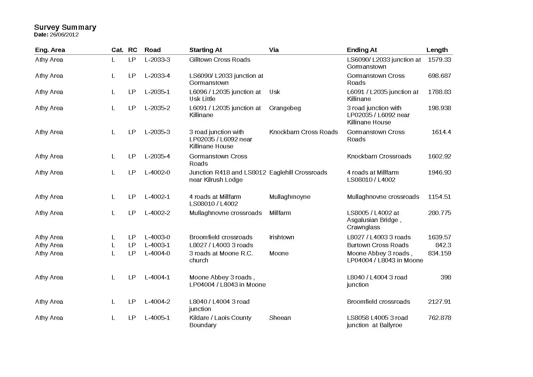 .
.