Key:flood_mark
| Description |
|---|
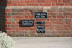
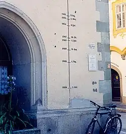
| A flood mark is a point that represents recorded maximum of water table. It is usually a plaque or pole with marked level of flood. |
| Group: historic |
| Used on these elements |
| Documented values: 2 |
| Useful combination |
| Status: in use |
| Tools for this tag |
|
A flood mark is a point that represents recorded maximum of water table. It is usually a plaque or pole with marked level of flood.
Examples
How to map
Place a node ![]() at the location of the flood mark. Tag with
at the location of the flood mark. Tag with historic=flood_mark and appropriate flood_mark key value:
=plaque- as first image above (made of metal, rock, wood),=painting- as second image above,=engraving- usually inscription (made on rock, wall),=pole- usually with several marks,=yes- otherwise.
Tags to use in combination
historic=flood_mark- historical significanceflood_date=*- the date of the flood written as yyyy-mm-dd (alternatives: yyyy-mm and yyyy); followingdate=*syntaxinscription=*- the text of an inscription that may be found on the flood marklocation=*- indoor, outdoorsource=*- source of informationnote=*- additional informationtourism=attraction
Related tags
This project is continuation and extension of Key:high_water_mark. Within few weeks high_water_mark will be replaced (merged).
historic=highwater_mark(lower use)