Key:light_rail
 |
| Description |
|---|
| Specifies whether light rail trains stop at a feature. |
| Group: public transport |
| Used on these elements |
| Useful combination |
| See also |
| Status: de facto |
| Tools for this tag |
|
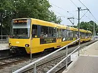
The key =yes/no is used to specify whether light rail trains stop at a feature such as a train station or platform. "Light rail" is a higher-standard tram system, often separated from other traffic for part or much of the way.
How to map
- This tag should be used solely within the
public_transport=*schema. It should not be used in combination with anyrailway=*tags. - Add the tag
=yesto a feature such as apublic_transport=stop_positionto specify that light rail trains stop at this feature. This is mainly useful when the same feature, such as a station, is shared by ahighway=*with a bus. - Add the tag
=noto a feature when light rail trains do not stop there, even though they might otherwise be expected to.
- Some mappers use
public_transport=platformandpublic_transport=stationfeatures in combination with this tag instead of adding the more common tagsrailway=platformandrailway=station. However this tagging is not as popular, nor approved as part of the proposal[1] and is not widely supported by database users.
- Some mappers add
=yes/notopublic_transport=stop_positionon a node of therailway=light_railway to show where a light rail train usually stops at a platform, halt or station, however, database users may also obtain the same information from therailway=light_railtag on the way which the node shares.
See also
train=*- specifies whether a train stops at a feature - usually not a subway, monorail or tram, but might overlap with light_railtram=*- specifies whether trams or streetcars stop at a featuresubway=*- specifies whether a subway train stops at a featuremonorail=*- specifies whether monorail trains stop at a featurerailway=station,railway=haltallowing to mostly skip using this tag