Key:portage
 |
| Description |
|---|
| Access for carrying small boats on foot. |
| Group: restrictions |
| Used on these elements |
| Useful combination |
| Status: in use |
| Tools for this tag |
|
=* is the access tag for ![]() portaging, the carrying of small boats such as canoes over land. The tag is applied to
portaging, the carrying of small boats such as canoes over land. The tag is applied to highway=* features to specify where portaging is allowed.
Background
Portages, or carries, are places where paddlers haul their boats and gear over land. Typically this is to get around obstructions such as dams, waterfalls, rapids, or low-flow waterways. Other reasons to portage include accessing waterways from parking areas and crossing between watersheds. Portages range in length from a few feet to a few miles.
While the ability to portage might generally correspond to foot=* access, there are many cases where portage access differs. For example, a power company or other landowner may allow access to a path around a dam for portaging paddlers, but not for other users. In other cases, multiple viable walking paths may exist between two waterways, but only one is signed as the portage route.
Values
=designated: the route is maintained, signed, or otherwise intended as a public portage by someone=yes: the route is useful as a portage between places=permissive: the route is on private property, portaging is allowed but could be restricted at any time=permit: portaging is allowed only with prior permission, which is usually granted=discouraged: portaging is allowed and feasible but is not recommended, perhaps due to poor conditions=customers: portaging is allowed only for patrons to a business, such as a resort or campground=private: portaging is restricted by the landowner and is not allowed by the general public=no: portaging is illegal or not physically possible (but may be enticing)
How to map
Portages are part of both the highway network and the waterway network. Add =* to each ways that forms part of the portage. All portage segments should have an appropriate highway=* tag. Portages should terminate at water access points and connect to waterway=* features. You can also add =* tags to barrier=* nodes to affect routing.
Some portages are accessible only via water. Ignore any "disconnected path" validator warnings for "routing islands". Do not add paths that don't exist to silence warnings.
Prefer pedestrian routes to vehicle routes. If a portage route is along a road, and a sidewalk exists, tag that as the portage instead of the road.
Avoid over-tagging. Theoretically you can haul a boat over most paths, but you should only add =yes if the route is useful to paddlers.
Wheeled portages
Some paddlers travel with small sets of wheels intended for carting their boats and gear over land. The hand_cart=* tag is suitable for indicating if carting is allowed and possible. Attribute tags such as surface=*, smoothness=*, width=*, and incline=* are also helpful to give paddlers more info about portage conditions.
Note that wheeled devices are strictly forbidden in ![]() US wilderness areas except as mobility aids. Portages in these places should be tagged
US wilderness areas except as mobility aids. Portages in these places should be tagged hand_cart=no.
Vehicle portages
The =* tag is not suitable for portages that require a vehicle such as a truck or cargo bicycle. Such portages require advanced planning and are not expected to be available to a typical paddler. Once a canoe is loaded onto a vehicle, it is subject to that vehicle's access restrictions. If regular shuttle service is available, you can map it as a route relation.
Gallery
-
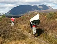
 Signed portage routes would typically be tagged
=designated. -
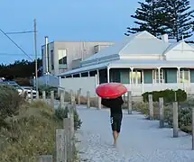
 Portages may interface with urban environments. Some include sidewalks or road shoulders.
 -
 Paths between waterways and parking lots, boathouses, etc. can also be tagged as portages.
 -
 Walkable waterways too shallow to paddle may be tagged
=yes. -
 Add
Addhand_cart=*to indicate if boats can be hauled on wheels.
Examples
- 1097146047
 1097146047 – maintained path between ponds in the
  Saint Regis Canoe Area
 - 1216382707 1216382707 – section of a bike trail that can be used to portage between two canal basins
- 1225564180 1225564180 – public sidewalk, part of the La Chute Portage between Lake George and Lake Champlain
- 1225730230 1225730230 – informal path on a river island that is used get around a pair of small dams
- 197309716 197309716 – hydroelectric dam service road that allows portaging only with advanced permission of the power company
- 369008805 369008805 – trail between a parking area and a river inside a US wilderness area where vehicles and carts are prohibited
Routing guidance

Those routing paddlers on canoe portages should expect =designated to indicate the highest quality route, followed by =yes and then =permissive. Note that =permit requires paddlers to obtain advanced permission, which may take a day or more to receive. Paths tagged =discouraged should be avoided except when no other route is possible to escape a waterway. Routing over =private and =customers may depend on the application but should generally be avoided. Ways tagged =no should not be considered traversible in any scenario.
The =* tag is not strictly required to route paddlers over land. Where =* values are absent, routers may choose to route based on foot=* access, with the assumption that hauling boats is allowed on public foot paths. End users should be made aware of the difference between explicit and assumed portage routes.
When routing other traffic types, extra care should be given around portage routes. People carrying boats are slow-moving with a reduced ability to respond to cars or other danger.
Alternative tagging
Historically, some mappers have used canoe=portage on highway features to specify portages. However, this tag cannot fully describe all portage access scenarios, and is ambiguous to non-canoe portaging. The =* tag solves these problems by applying existing OSM access tagging patterns to describe any type of small boat carry. While you could still add canoe=portage alongside =*, the latter makes the former superfluous. Also, by freeing up the canoe=* key to be purely used for access, we can do things like tag shallow waterways with =yes and canoe=no.
Other tags mappers have previously used for portages include waterway=portage, whitewater=portage_way, whitewater=portage, and kayak=portage.