Key:symbol
 |
| Description |
|---|
| Human-Readable Description of Route Symbols that are used as waymarkers or on guideposts |
| Group: properties |
| Used on these elements |
| Useful combination |
| See also |
| Status: de facto |
| Tools for this tag |
|
=* is a human readable equivalent of osmc:symbol=*, both describe route symbols that are used as waymarkers or on guideposts
See Walking Routes for country specific use of this tag.
Description
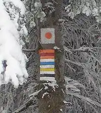
The symbol tag is used for describing symbols of hiking and other trails in a human readable form. It is usually accompanied with osmc:symbol=*, which contains a machine readable description of the symbol of the trail. Example:
=red bar on white groundosmc:symbol=red:white:red_bar→
You can use international naming options in this format:
=red bar ...symbol:hu=piros sáv ...
Implementing software may choose to use a local database for connecting osmc:symbol=* values to an icon or to a name, or it can choose to loud read the value of the =* tag.
A routing software might say: "Turn left to the red bar and follow for two kilometers."
Examples
- Hungarian Hiking page
- WikiProject_Slovakia/Hiking_routes#Hiking_Routes_Marker_Symbols
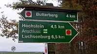
- Symbols on guidepost:
See also
osmc:symbol=*- Machine-Readable representation of route symbol that is used as waymarker or on guideposts.wiki:symbol=*- OpenStreetMap Wiki Symbol References of Hiking Path Symbols.information=guidepost- Used to mark a guidepost/signpost.destination:symbol=*- To indicate that a special symbol/icon is present on a signpost, visible as road marking or similar.