Lebanon: Conflict - October 2024
| General Information | |||||||||||||||
Context of the Activation 22 October, 2024: Recent conflict has impacted the humanitarian situation in southern Lebanon. To better inform humanitarian operations, HOT has been requested by humanitarian organizations to support the creation of a comprehensive dataset of building footprints. Very little previous mapping has been done in the area, with up to an estimated 90% of buildings not in OSM in some districts. To assist the response, you can support the update of southern Lebanon’s OSM building footprints (pre-conflict). Please see the Contributor Guidelines (Google Document) for pointers on how to participate responsibly in areas of active conflict. | |||||||||||||||
For Aid Organizations
Map and Data Services
Exporting OpenStreetMap data
See Downloading data for instructions on getting large scale map data, or see the focused exports below:
- Lebanon OSM buildings (data refreshed daily)
About This Disaster Activation
About HOT
To learn more about the Humanitarian OpenStreetMap Team (HOT), explore more of our wiki-pages (root: HOT) or our website hotosm.org. HOT is a global community, mostly of volunteers, and it is a US registered nonprofit able to contract with organizations (email info at hotosm.org to contact our staff), we are also a 501(c)(3) charitable organization.
History of this Activation
- September - October 2024: HOT conducted data ethics and protection assessment to consider commencing mapping in Lebanon
- 22 October 2024: HOT posted on OSM Commnuity Forum to share plans and seek feedback
- 24 October 2024: First project published in southern Lebanon
- 26 November 2024: Israel and Lebanon’s Hezbollah reach ceasefire deal (AP News)
Relevant blog posts
Coordination
- Lead(s):
- Jessie Pechmann (Coordination Lead) - data@hotosm.org
Community consultation:
Consultation with the OSM community is underway on the OSM community forum
Data Quality
This mapping is complex due to the amount of existing data, the density of the built environment and the mis-alignment of OSM data to satellite imagery among other factors. For these reasons mapping permissions in the Tasking Manager are limited to the most advanced contributors (including the HOT Global Validators team) who have been manually selected.
All contributions through HOT's Tasking Manager are tracked with a unique changeset comment tag for this campaign: #lebanonUpdate2024
Validation
Validation permissions for Tasking Manager projects are restricted to particular Tasking Manager Teams / users to ensure high quality validation:
OSMCha
A specific OSMCha filter can be used to detect data quality issues across a wider area.
Scope and Scale
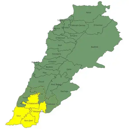
This project is part of a campaign to map building footprints pre-conflict in OSM across the 7 most southern districts of Lebanon: Jessine, Saida, El Nabatieh, Hasbaya, Marjaayoun, Sour, Bent Jbeil. Building footprints will be used by humanitarian organizations to plan aid delivery and understand the impact of the conflict on the area. See dedicated uMap for project extents.
The Tasking Manager project extents have taken OCHA's Lebanon - Subnational Administrative Boundaries from HDX at Administrative level 2 (Lebanon Districts) and split them into three or more parts each.
Please see the Contributor Guidelines (Google Document) for pointers on how to participate responsibly in areas of active conflict.
Post Event Mapping
In areas where building footprints are complete HOT intends to coordinate the addition of destroyed and damaged lifecycle tags to the footprints based on post-event data. The process for this and the post-event data sources are currently being explored.
We will keep a list of reference points and ideas here that can contribute to an appropriate workflow.
- See Key:destroyed:*
- See Key:damage:*
For Mappers
How You Can Contribute
Mapping Priority
All active projects can be seen in this filtered campaign list. All active, draft and archived projects can be seen here with live status updates.
| Project | Priority | Name | What to map | Imagery Source | Mapping Status | Validation Status | Publish date | Completion date |
|---|---|---|---|---|---|---|---|---|
| 17910 | High | Lebanon Conflict: Sour 1 | Buildings | Esri World Imagery | 100% | 100% | 24 Oct 2024 | 1 Nov 2024 |
| 17928 | High | Lebanon Conflict: Bent Jbeil 1 | Buildings | Esri World Imagery | 100% | 100% | 31 Oct 2024 | 17 Nov 2024 |
| 18066 | Urgent | Lebanon Conflict: Sour 2 | Buildings | Esri World Imagery | 100% | 100% | 17 Nov 2024 | 26 Nov 2024 |
| 18118 | Urgent | Lebanon Conflict: Marjaayoun 1 | Buildings | Esri World Imagery | 100% | 100% | 26 Nov 2024 | 4 Dec 2024 |
| 18200 | Urgent | Lebanon Conflict: Marjaayoun 2 | Buildings | Esri World Imagery | 100% | 100% | 4 Dec 2024 | 11 Dec 2024 |
| 18213 | Urgent | Lebanon Conflict: Marjaayoun 3 | Buildings | Esri World Imagery | 100% | 100% | 11 Dec 2024 | 13 Dec 2024 |
| 18228 | Urgent | Lebanon Conflict: Sour 3 | Buildings | Esri World Imagery | 100% | 100% | 13 Dec 2024 | 12 Jan 2025 |
| 18260 | Urgent | Lebanon Conflict: Bent Jbeil 2 | Buildings | Esri World Imagery | 100% | 100% | 12 Jan 2025 | 25 Jan 2025 |
| 18261 | Urgent | Lebanon Conflict: Bent Jbeil 3 | Buildings | Esri World Imagery | 100% | 100% | 25 Jan 2025 | 1 Feb 2025 |
| 18391 | Urgent | Lebanon Conflict: Nabatieh 1 | Buildings | Esri World Imagery | 100% | 100% | 3 Feb 2025 | 17 Feb 2025 |
| 18425 | Urgent | Lebanon Conflict: Nabatieh 2 | Buildings | Esri World Imagery | 100% | 100% | 18 Feb 2025 | 20 Mar 2025 |
| 18528 | Urgent | Lebanon Conflict: Nabatieh 3 | Buildings | Esri World Imagery | 100% | 100% | 19 Mar 2025 | 30 Mar 2025 |
Training for New Mappers
The page LearnOSM provides information to help mappers new to OSM get started. See the training guides:
The basic tasking manager projects for this project will follow our standard mapping workflow used across all HOT activations. Here is a link to the workflow details.
Explaining this Mapping
HOT manages many different OSM data projects including editing new roads, buildings, waterways, health facilities and more. The “mapping” for this disaster response focuses on updating OSM building footprints to aid humanitarian efforts post-event.
OSM Map Data includes mapping visible features such as roads, buildings, etc. from satellite imagery or GPS tracks, and requires an internet connection for access.
Mapping Landuse
As part of this project, HOTOSM and its partners will update Lebanon's land use data. This initiative is crucial because the country has experienced rapid changes driven by economic challenges and population displacement. The situation requires timely and accurate mapping to support effective planning and humanitarian response.
| Level 2 | Description | Suggested OSM Tag | Pictures |
|---|---|---|---|
| Open field cultivation | Rain-fed or irrigated row crops | landuse=agriculture | Image |
| Orchards | Planted tree crops (fruit/nuts) | landuse=orchard | Image |
| Intensive cultivation | High-input, high-yield crop production | landuse=farmland | Image |
| Agricultural building | Structure for farming operations | building=yes | Image |
| Unbuilt artificialized area | Human-modified land without construction | ||
| Shrub area | Dense low woody vegetation (<5m height) | natural=scrub | |
| Sparse forest | Open-canopy woodland (10-30% tree cover) | natural=wood | |
| Dense forest | Closed-canopy woodland (>70% tree cover) | natural=wood | |
| Medium-dense herbaceous vegetation | Grassland or shrubland with moderate cover (30-70%) | natural=grassland | |
| Urbanized area | Built-up land with dense infrastructure | landuse=residential landuse=commercial |
|
| Activity area | Zone designated for specific human use | landuse=residential landuse=commercial |
|
| Artificial green area (non-agricultural) | Human-planted vegetation for recreation/beautification | ||
| Wetland or maritime marsh (including saline) | Water-saturated land, fresh or saline | natural=wetland + wetland=marsh natural=wetland + wetland=saltmarsh |
|
| Rocky outcrop | Isolated exposed bedrock formation | natural=rock | |
| Bare rock | Natural exposed bedrock or boulders | natural=bare_rock | |
| Beach | Sandy or pebbly shoreline zone | natural=beach | |
| Bare ground | Unvegetated, exposed soil or rock | ||
| River or stream | Natural flowing freshwater channel | (line) waterway=river (polygon) natural=water |
|
| Highway | Major road for high-speed traffic | highway=* | |
| Marine water surface | Seas, coastal waters, maritime zones | ||
| Continental water surface | Natural or artificial inland water bodies | natural=water | |
| Fire zone | High-risk wildfire-prone protected land |
Mapping Instructions
Imagery
Please use ESRI World Imagery to map. This imagery was mostly captured between late 2022-mid 2023 so it should provide ‘pre-event’ building footprints with which to add damage/destroyed attributes once more up-to-date imagery is available. To check the date of the Esri imagery that you are mapping with, zoom into this map.
If the low image quality of Esri World Imagery is making it difficult to distinguish buildings / building shapes please feel free to use older Bing imagery for comparison, switching between the two but using the Esri imagery to trace and align.
Map using ESRI World Imagery with no offset
Some existing buildings are not perfectly aligned with the imagery, some are well aligned. For the sake of consistency please map using ESRI World Imagery with no offset.
Most roads are well aligned and should not be an issue, but please take care to avoid buildings and roads intersecting. You may need to alter the position of a road or two to ensure this, but do not feel the need to perfectly align all the roads (or other objects) only focus on those that may cause issues for mapping the new buildings.
Some buildings are tall, and their footprints are mapped - be careful not to think a building is out of alignment because its roof is offset to the ground footprint. Check for this carefully.
Correct existing buildings
Some buildings are already mapped across the area. However, they may have been adapted over time, or previous mappers may have made mistakes. Please focus on correcting existing mapped buildings first.
Try to preserve the history of buildings whenever possible by using replace geometry (Shift + Ctrl + G in JOSM) with the old building and your new building both selected. You're also likely to have to be squaring, moving, disconnecting, resizing and rotating buildings to ensure a better fit with the later imagery.
Map all other buildings
Once you have fixed previously mapped buildings, focus on mapping the buildings that are not mapped yet - these have likely been built since the last mapping efforts were made with older imagery.
Damaged infrastructure
We recommend activating two JOSM paint styles to highlight buildings with lifecycle tags:
- Color Ways paint style highlights buildings with damage/destroyed tags
- Missing Maps / Youth Mappers Validators checks highlights buildings with any tag other than 'building=yes', importantly this highlights ruins tags.
Both can be activated by going to Edit > Preferences > Map Paint Styles. Select 'Color Ways' and 'Missing Maps / Youth Mappers Validators checks' from the left-hand list and click the right facing arrow to move both to the 'Active styles' list.