MUTCD/Michigan/W
Series W of the MMUTCD is for warning signs. The following tables display only the signs specific to the MMUTCD in Michigan; consult MUTCD/W for warning signs in the national standard.
Work zone usage
This series includes temporary traffic control warning signs for use in work zones (construction zones). Whereas a regulatory sign appears the same inside and outside a work zone, a warning sign has an orange background instead of the usual yellow when used in a work zone.
- W3-4b
-
 Warning use
 -
 Work zone use
In general, OpenStreetMap only maps long-term closures and construction sites. For routing purposes, short-term construction is more reliably and efficiently tracked in incident management systems along with real-time traffic congestion data. However, if a temporary sign happens to be posted on a long-term basis for some reason, you can map it as you would map a normal sign. If you map the work zone use traffic sign as a node, use a W code but add colour=orange to the node.
W1: Curves and Turns
| Sign or plaque | Designation | Name | Tags | Notes |
|---|---|---|---|---|

|
W1-2bR | Two Lane Curve Sign (right) | ||

|
W1-2bL | Two Lane Curve Sign (left) |
W3: Advance Traffic Control
| Sign or plaque | Designation | Name | Tags | Notes |
|---|---|---|---|---|
|
|
W3-4b | Prepare to Stop When Flashing | ||
 
|
W3-5a | XX mph Speed Zone Ahead | ||
 
|
W3-5b | Reduced Speed Zone Ahead |
W6: Divided Highways
| Sign or plaque | Designation | Name | Tags | Notes |
|---|---|---|---|---|

|
W6-5 | Triple Arrow |
W8: Pavement and Roadway Conditions
| Sign or plaque | Designation | Name | Tags | Notes |
|---|---|---|---|---|

|
W8-26 | Rumble Strips Ahead |
W9: Lane Transitions
| Sign or plaque | Designation | Name | Tags | Notes |
|---|---|---|---|---|

|
W9-3a | Center & Left Lane Closed Ahead | ||

|
W9-3b | Center & Left 2 Lanes Closed Ahead |
W11: Advance Warnings and Crossings
| Sign or plaque | Designation | Name | Tags | Notes |
|---|---|---|---|---|

|
W11-10a | Truck Crossing Text | ||

|
W11-10b | Factory Entrance | ||

|
W11-20a | Elk Crossing Text | ||

|
W11-21a | Moose Crossing Text | ||

|
W11-23 | ATV Symbol | ||

|
W11-24 | Watch for Ramp Traffic |
W12: Low Clearance
| Sign or plaque | Designation | Name | Tags | Notes |
|---|---|---|---|---|
| W12-2aP | Low Clearance (plaque) | |||
| W12-3 | Vertical Underclearance | |||
| W12-3a | Vertical Underclearance with Arrow |
W13: Advisory Speeds
| Sign or plaque | Designation | Name | Tags | Notes |
|---|---|---|---|---|
|
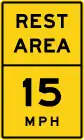
W13-3c | Rest Area Advisory Speed | maxspeed:advisory=15 mph on the ramps and the service roads within the rest areahighway=rest_area nearby
| |
|
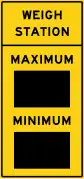
W13-3d | Weigh Station Maximum and Minimum Speed | maxspeed:advisory=* minspeed:advisory=* on the ramps and the service roads within the weigh stationamenity=vehicle_inspection around the weigh stationamenity=weighbridge at the truck scales |
Speculative |
|
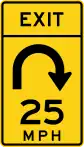
W13-6a | Exit Advisory Speed 180 Degrees | maxspeed:advisory=25 mph hazard=curve curve=hairpin on the ramphighway=motorway_junction at the beginning of the ramp
| |
|
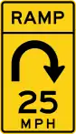
W13-7a | Ramp Advisory Speed 180 Degrees | maxspeed:advisory=25 mph hazard=curve curve=hairpin on the ramp
|
W14: Dead End Streets and No Passing Zones
| Sign or plaque | Designation | Name | Tags | Notes |
|---|---|---|---|---|

|
W14-2b | Road Ends |
W16: Supplemental
| Sign or plaque | Designation | Name | Tags | Notes |
|---|---|---|---|---|

|
W16-4aP | Next X Miles (two lines, plaque) | ||
| W16-4bP | Next X Miles (one line, plaque) | |||
| W16-4cP | Next XXX ft (plaque) | |||
| W16-7P(R) | Angled-Down Arrow (plaque) | |||
| W16-7P(L) | Angled-Down Arrow (plaque) | |||
| File:MUTCD-MI W16-8P.svg | W16-8P | Road Name (plaque) | ||
| File:MUTCD-MI W16-8aP.svg | W16-8aP | Double Road Name (plaque) | ||
| File:MUTCD-MI W16-9P.svg | W16-9P | Ahead (plaque) | ||
| W16-17P | Roundabout (plaque) | |||
| File:MUTCD-MI W16-19.svg | W16-19 | Exit Advisory Speed Advance Turn | ||
| File:MUTCD-MI W16-20P.svg | W16-20P | Closed Foldable Sign (Freeway) | ||
| File:MUTCD-MI W16-21P.svg | W16-21P | Closed Foldable Sign (Freeway) | ||
| File:MUTCD-MI W16-22P.svg File:MUTCD-MI W16-22P PARK CLOSED.svg |
W16-22P | Closed Foldable Sign (Non-freeway) |
W19: End of Controlled Access Highway
| Sign or plaque | Designation | Name | Tags | Notes |
|---|---|---|---|---|
| W19-1 | Freeway Ends 1 Mile |
W20: Work Zones
| Sign or plaque | Designation | Name | Tags | Notes |
|---|---|---|---|---|
 
|
W20-4c | Watch For Emergency Vehicles | ||

|
W20-7a | Traffic Regulator Symbol | ||
| W20-8 | Sidewalk Closed Ahead | |||
| File:MUTCD-MI CW20-9.svg | W20-9 | Crossover Closed/Use Next Crossover | ||
| File:MUTCD-MI CW20-10.svg | W20-10 | Concrete Curing | ||
| W20-11 | Temp Bus Stop | |||
| File:MUTCD-MI CW20-12P.svg | W20-12P | Road Name (above M4-8a and M4-9 series) | ||
| File:MUTCD-MI CW20-13P.svg | W20-13P | Road Name (below 48" diamond) | ||

|
W20-14 | Late Merge | ||
| File:MUTCD-MI CW20-14aP.svg | W20-14aP | Take Turns | ||
| File:MUTCD-MI CW20-14bP.svg | W20-14bP | Left Lane | ||
| File:MUTCD-MI CW20-15.svg | W20-15 | Stay in Your Lane | ||
| File:MUTCD-MI CW20-15a.svg | W20-15a | Prepare for Backups | ||
| File:MUTCD-MI CW20-15b.svg | W20-15b | Watch for Traffic Backups Be Prepared to Stop | ||
| File:MUTCD-MI CW20-16.svg | W20-16 | Truck Entering & Exiting Roadway | ||
| File:MUTCD-MI CW20-17.svg | W20-17 | Exit Open Ahead | ||

|
W20-18 | Emergency Pull Off Area 1/2 Mile | ||

|
W20-18a | Emergency Pull Off Area 500 Feet |
W23: Slow Traffic
| Sign or plaque | Designation | Name | Tags | Notes |
|---|---|---|---|---|

|
W23-2 | New Traffic Pattern Ahead |