- This is the desktop application for macOS; if you are looking for the mobile app for iPhone it is myTracks for iOS, and on Android a different app is My Tracks by Google.
| myTracks
|
|
|
| Author:
|
Dirk Stichling
|
| License:
|
Proprietary (9.95 Euro)
|
| Platform:
|
macOS
|
| Version:
|
2.2.11 (2010-10-10)
|
| Languages:
|
German, English, French, and Japanese
|
| Website:
|
http://www.mytracks4mac.com
|
| Install:
|
|
|
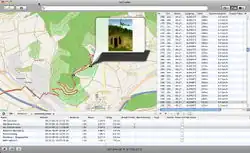
Viewer for GPS tracks, waypoints and geotagged photos
|
|
Features
| Feature
|
Value
|
| Map Display
|
| Display map
|
yes
|
| Map data
|
raster
|
| Source
|
online
|
| Rotate map
|
no
|
| 3D view
|
no
|
| Shows website
|
?
|
| Shows phone number
|
?
|
| Shows operation hours
|
?
|
| Routing
|
| Routing
|
no
|
| Create route manually
|
?
|
| Calculate route
|
?
|
| Create route via Waypoints
|
?
|
| Routing profiles
|
?
|
| Turn restrictions
|
?
|
| Calculate route without Internet (Offline routing)
|
?
|
| Routing providers
|
?
|
| Avoid traffic
|
?
|
| Traffic Provider
|
?
|
| Navigating
|
| Navigate
|
no
|
| Find location
|
?
|
| Find nearby POIs
|
?
|
| Navigate to point
|
?
|
| Navigation with voice / Voice guidance
|
?
|
| Keep on road
|
?
|
| Lane guidance
|
?
|
| Works without GPS
|
?
|
| Navigate along predefined route
|
?
|
| Tracking
|
| Make track
|
yes
|
| Customizable log interval
|
yes;no
|
| Track formats
|
?
|
| Geotagging
|
photo
|
| Fast POI buttons
|
no
|
| Upload GPX to OSM
|
no
|
| Monitoring
|
| Monitoring
|
no
|
| Show current track
|
no
|
| Open existing track
|
yes
|
| Altitude diagram
|
?
|
| Show POD value
|
?
|
| Satellite view
|
?
|
| Show live NMEA data
|
?
|
| Show speed
|
?
|
| Send current position
|
no
|
| Editing
?
|
| Rendering
?
|
| Accessibility
?
|
|
|
myTracks is a program for organizing and displaying gps tracks, waypoints and digital pictures with geo data. It runs under Mac OS X and iOS and synchronizes data beetween the two worlds.
Weblinks