Philippines/Projects

Present projects
- OSMaPaaralan - The big project for the time. Its goal is to map every public school an most corners of the country. Also part of the MapaTime initiative.
- Philippines/Addressing - Addresses in the Philippines have some characteristics not compatible with the Karlsruhe addressing scheme
- Philippines/Numbered routes - Ongoing efforts to map numbered routes introduced from 2014
- Power networks/Philippines - Most features related to the national power grid has been mapped in detail.
- Philippines/Public transportation – Mapping public transportation systems in the Philippines, from jeepneys to buses and trains.
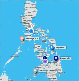
- TM Open Buildings - Mapping selected areas in 12 Philippine cities.
- UNMAPPEDPH - Project aimed to map the most unmapped towns' and provinces' building footprints on OpenStreetMap.
- Baguio City Drone Aerial Data - Project from capturing aerial images to hosting them on Geoserver to support OSM Mapping in Baguio
Past projects
- Participatory mapping and LGU decision support tools for Disaster Risk Reduction (DRR) - a disaster risk reduction pilot mapping project implemented to 3 municipalities in Pampanga for updating the LGU's basemaps using OpenStreetMap and InaSAFE. Implemented by the Environmental Science for Social Change and OSM-PH supported by WorldBank GFDRR. Implementation period: May - December 2013. See project brochure and WB-GFDRR's publication.
- Swiss Red Cross and PRC mapping in Busuanga
- OpenRoads
- Luzon road and waterway remote mapping - Implementation period: May 2014.
- Crowd-sourced Mapping Worshops by The Asia Foundation - Conducted in Tagbilaran, Iloilo City, Butuan, Dumaguete.
| |||||||||||||||||||||||||||||||||||||||||