Power networks/Gabon
| Gabon (GA) | |
|---|---|
 .svg.png) | |
| References | |
| OpenStreetMap | 192793 |
| Wikidata | Q1000 |
| Wikipédia | Gabon https://en.wikipedia.org/wiki/Energy_in_Gabon |
| Country characteristics | |
| Continent | Africa |
| Population | 2,300,000 |
| Area | 267,667 km2 |
| GDP | 4.8 B$ |
| Language(s) | French |
| Electrical Network | |
| Generation capacity | 291 MW (OSM) |
| Power line length | 450 km (OSM) |
| Frequency | ... Hz |
| Transmission lines voltages (kV) | 225kV, 90 kV, 63 kV |
| Data from Wikidata (last update 2025-05-17) and OpenInfraMap (last update 2025-07-22) | |
This page has been created through the power networks country page template. Check the template page for more information on how to complete it.
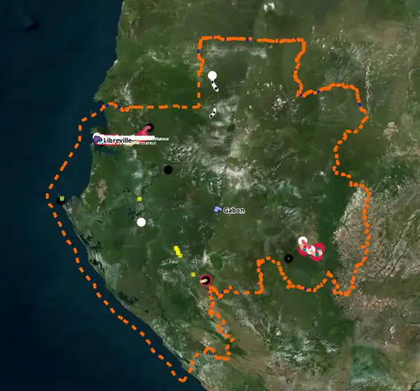
High-voltage Electrical Network
State of the map
in 2025-05:
Network description
Voltages and frequency
Frequency : TODO Hz
Voltage source [1]
| Network | Voltage | Comments | Appearance |
|---|---|---|---|
| Transmission | 225 kV | ||
| Transmission | 90 kV | ||
| Transmission | 63 kV | ||
| Distribution | 30 kV | ||
| Distribution | 20 kV | ||
| Distribution | 5.5 kV |
Operators
| Operator | Network | Wikidata | Website | Wikipedia | Operating area | Information | Label | Taginfo |
|---|---|---|---|---|---|---|---|---|
| Société d'énergie et d'eau du Gabon (SEEG) | Transmission | Q3487856 WhatLinksHere |
https://www.seeg-gabon.com/ | fr:Société_d'énergie_et_d'eau_du_Gabon | operator=SEEGoperator:wikidata=Q3487856
|
operator=SEEG |
Interconnections
| Neighbour country | Structure name | Year of commissioning | Technology | Voltage | Local end | Foreign end | OSM circuit | Notes |
|---|---|---|---|---|---|---|---|---|
| TODO | xxx |
Planned projects
- deux projets de barrages dans la province de Ngounié
- projet de centrale hydroélectrique de Ngoulmendjin (73 MW), localité située à 125 km de Libreville sur le fleuve Komo
Data Sources
| Source | License | Date | Suitable for OSM | Notes |
|---|---|---|---|---|
| https://energydata.info/dataset/gabon-power-plants | CC-BY | 2009 | no | access denied |
| https://energydata.info/dataset/gabon-electricity-transmission-network | CC-BY | 2009 | no | access denied |
| https://energydata.info/dataset/gabon-electricity-transmission-network-2007 | CC-BY | 2007 | no | access denied |
Network statistics
Gabon has 10 power plants totalling 291 MW and 450 km of power lines mapped on OpenStreetMap (from OpenInfraMap, last update 2025-07-22)
Power line
| Power Lines Voltage | Length |
|---|---|
| < 10 kV | 0 km |
| 10 kV - 25 kV | 0 km |
| 25 kV - 52 kV | 0 km |
| 52 kV - 132 kV | 197 km |
| 132 kV - 220 kV | 0 km |
| 220 kV - 330 kV | 178 km |
| 330 kV - 550 kV | 0 km |
| > 550 kV | 0 km |
| No voltage tagged | 74 km |
| Total | 450 km |
Electricity generation
Mapping process and community
Mapping success stories
TODO : Success stories are designed to highlight important contributions. Have you significantly improved the cartography of a country (added a new line, a power station, etc.)? Don't be shy, let us know below.
- Example : NAME [DATE YYYY-MM-DD]: My success stories in words.
Encountered problems and places to improve
- ....
Use of mapping strategies
TODO : Mapping strategies refer to Power networks/Guidelines#Mapping strategies. They are used for a methodical improvement of the OSM database. Once you have fully applied a strategy in this country, you should add or update your name, the date, the strategy, and a comment below. This way, other users can see whether it is worthwhile to carry out further investigations.
- Example : Search for "Unfinished major power lines" - last time applied by XXX [2025-MM-DD]
- .... - last time applied by XXX [2025-MM-DD]