| Relief Maps
|
|
|
| Author:
|
Relief Maps
|
| License:
|
Proprietary (free (purchases available))
|
| Platforms:
|
Android and iOS
|
| Version:
|
0.5.1 (2019-09-24)
|
| Languages:
|
English and French
|
| Website:
|
https://reliefmaps.io/
|
| Install:
|
|
|
proprietary outdoors-oriented map app
|
|
Features
| Feature
|
Value
|
| Map Display
|
| Display map
|
yes
|
| Map data
|
?
|
| Source
|
?
|
| Rotate map
|
yes
|
| 3D view
|
yes
|
| Shows website
|
?
|
| Shows phone number
|
?
|
| Shows operation hours
|
?
|
| Routing
|
| Routing
|
yes
|
| Create route manually
|
?
|
| Calculate route
|
?
|
| Create route via Waypoints
|
?
|
| Routing profiles
|
yes
|
| Turn restrictions
|
?
|
| Calculate route without Internet (Offline routing)
|
?
|
| Routing providers
|
?
|
| Avoid traffic
|
?
|
| Traffic Provider
|
?
|
| Navigating
|
| Navigate
|
?
|
| Find location
|
yes
|
| Find nearby POIs
|
?
|
| Navigate to point
|
yes
|
| Navigation with voice / Voice guidance
|
no
|
| Keep on road
|
no
|
| Lane guidance
|
?
|
| Works without GPS
|
yes
|
| Navigate along predefined route
|
?
|
| Tracking
|
| Make track
|
yes
|
| Customizable log interval
|
no
|
| Track formats
|
?
|
| Geotagging
|
note;photo
|
| Fast POI buttons
|
?
|
| Upload GPX to OSM
|
yes
|
| Monitoring
|
| Monitoring
|
?
|
| Show current track
|
yes
|
| Open existing track
|
yes
|
| Altitude diagram
|
yes
|
| Show POD value
|
yes
|
| Satellite view
|
no
|
| Show live NMEA data
|
?
|
| Show speed
|
yes
|
| Send current position
|
?
|
| Editing
|
| Add POIs
|
no
|
| Edit / Delete POIs
|
no
|
| Add way
|
no
|
| Edit geometries
|
no
|
| Edit arbitrary tags of existing OSM objects
|
no
|
| Edit relations
|
no
|
| View notes
|
?
|
| Create notes
|
?
|
| Edit notes
|
?
|
| Work offline
|
no
|
| Support imagery offset DB
|
?
|
| Upload to OSM
|
no
|
| Rendering
?
|
| Accessibility
?
|
|
|
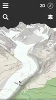
Relief Maps (reliefmaps.io) is a proprietary outdoors-oriented 3D GPS application for Android and iOS. The software is developed by Batiste Vonderweidt a solo maker, based in Annecy, France.
Features
- OSM maps
- Subscriptions are available for offline maps
- Track recording and display
- GPX import
- Routing
- ...