Sandy, Bedfordshire
| V・T・E |
| latitude: 52.1391, longitude: -0.3726 |
| Browse map of Sandy 52°08′20.76″ N, 0°22′21.36″ W |
| Edit map |
|
|
External links:
|
| Use this template for your locality |
Sandy is a town in Bedfordshire at latitude 52°08′20.76″ North, longitude 0°22′21.36″ West.
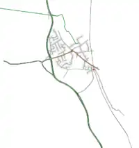
Notes
- Big green thing is the A1
- Railway line is Kings Cross to Peterborough
- Cycle route off the northwest goes to Willington and Bedford
- B-road to the east continues after it crosses the train line (on this map it stops by the national speed limit sign)
- Many of the residential areas in the north of the town haven't been mapped
- Everything south of the roundabout should be complete
- The main high street (if you want to buy stuff) is the one going southeast from the roundabout to the station