TIGER King
| TIGER King | ||||||||||||||||||||
|---|---|---|---|---|---|---|---|---|---|---|---|---|---|---|---|---|---|---|---|---|
 | ||||||||||||||||||||
| Author: | whammo | |||||||||||||||||||
| License: | MIT License | |||||||||||||||||||
| Platform: | Web | |||||||||||||||||||
| Status: | Active | |||||||||||||||||||
| Website: | https://whubsch.github.io/tigerking/ | |||||||||||||||||||
| Source code: | https://github.com/whubsch/tigerking | |||||||||||||||||||
| Programming language: | TypeScript | |||||||||||||||||||
|
Web interface to edit and clean up imported highways in the US |
||||||||||||||||||||
| ||||||||||||||||||||
TIGER King is a web-based tool for reviewing and fixing TIGER data. It helps mappers efficiently review ways tagged with tiger:reviewed=no and update them with correct surface and lane information.
Features
- Review TIGER ways within a relation, bounding box, or around a point
- Quick tags for common combinations of surface and lane attributes
- Preview tag changes before uploading
- Integrated iD, JOSM, and Rapid editor links
- Keyboard shortcuts for common actions
- Support for multiple aerial imagery sources
- OAuth authentication with OpenStreetMap
Usage
The tool can be accessed in four ways:
- By relation ID (e.g.
?relation=123456) - By bounding box (e.g.
?zoom=16&x=38.89&y=-77.11) - By center point (e.g.
?x=38.89&y=-77.11) - By individual way (e.g.
?way=8796378)
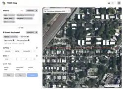
Interface
The interface consists of two main elements:
- Left panel for reviewing and editing way tags
- Right panel showing an aerial imagery map with the current way highlighted
See also
- OSM Community discussion about the tiger:reviewed tag
- TIGER_fixup