Tag:amenity=food_court
 |
| Description |
|---|
| A place with sit-down facilities shared by multiple self-service food vendors. |
| Rendering in OSM Carto |
| Group: food and beverages |
| Used on these elements |
| Useful combination |
|
| Status: de facto |
| Tools for this tag |
|
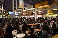
A ![]() food court (or food lounge) is a usually indoor place or area within a facility that is contiguous with the counters of multiple food vendors and provides a common area for self-serve dining. Food courts may be found in shopping malls and airports, and in various regions may be a standalone development. In some places of learning such as high schools and universities, food courts have also come to replace or complement traditional cafeterias.
food court (or food lounge) is a usually indoor place or area within a facility that is contiguous with the counters of multiple food vendors and provides a common area for self-serve dining. Food courts may be found in shopping malls and airports, and in various regions may be a standalone development. In some places of learning such as high schools and universities, food courts have also come to replace or complement traditional cafeterias.
Some mappers have taken to mapping ![]() food cart pods as food courts, optionally as areas with
food cart pods as food courts, optionally as areas with landuse=retail, given that they perform the same function, just usually outdoors and with a less permanent assortment of restaurants. This may be temporary as tagging evolves.
How to map
Set a node or draw as an area along the shop outline. Tag it with amenity= and name=*.
Tags used in combination
addr:*=*- the address of the food courtopening_hours=*- hours when the food court is openoperator=*- indicates the operator or name of the company operating the food courtwheelchair=no/yes/limited- suitable for wheelchairsphone=*- phone number of the food courtsmoking=*- whether smoking is permittedcuisine=*seasonal=*— indication when service is available with rough seasonal indication (value domains summer, winter, …)
See also
leisure=outdoor_seating— seating area located outside, usually for the consumption of food and drink from neighboring cafes and restaurantsamenity=restaurantamenity=canteenamenity=fast_foodamenity=bar