Tag:golf=hole
 |
| Description |
|---|
| The path from tee area to the green |
| Rendering in OSM Carto |

|
| Group: leisure |
| Used on these elements |
| Useful combination |
| Status: de facto |
| Tools for this tag |
|
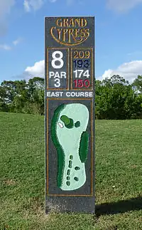
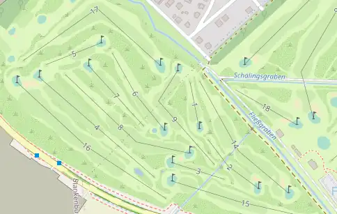
The hole is represented by a way along the standard playing path from tee area to the green. It's best to think about it as the path that a struck ball will take on the way to the green for a "par" or "scratch" golfer. The number of nodes that make up the way should be one fewer than the par on the hole. A par 3 hole will therefore be a straight line from the tee box to (roughly) the middle of the green, with no intermediary nodes. Intermediary nodes will typically be found in the middle of a fairway, of those are mapped, and will be the distance from the tee that a scratch golfer would be able to hit their first and second shots.
The way that defines the path should never share nodes with other golf features like tee boxes, bunker/sandtraps, fairways, etc. If you think about it as the path is the ball in the air, not along the ground, it makes sense that it wouldn't be connected to something on the ground.
How to map
Draw a way ![]() from the
from the tee to the pin and add golf=.
You can add
ref=*- number of the holepar=*- number of strokes normally required for this holedist=*- the distance of the holehandicap=*- difficulty ranking of a hole in a golf course from 1 to 18, used to determine the allocation of handicap shotsname=*- (rare) the common name of the hole, if there is one. Hole number belongs toref=*
Unless a golf hole has an actual name, use ref=*
For example, the Masters Golf Course in Augusta, Georgia, USA, not only assigns numbers to their golf holes, but specific names are assigned to each one;
Hole 1 – Tea Olive, Hole 2 – Pink Dogwood, etc.
In this case, both ref=* and name=* would be tagged on the golf hole. The tag ref=* would be used to describe hole numbers while the tag name=* would be used for the name of each hole.
If a hole does not have an actual name, ref=* is sufficient.
If values (par, handicap, dist) differ for different colour references, subkeys are in use, e.g.: par:red=* or handicap:blue=*.
Example
See also
leisure=golf_course- A golf course