Tag:highway=platform
 |
| Description |
|---|
| A platform at a bus stop or station. |
| Rendering in OSM Carto |

|
| Rendering in OSM Carto |

|
| Group: highways |
| Used on these elements |
| Useful combination |
| See also |
| Status: de facto |
| Tools for this tag |
|
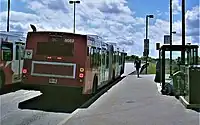
The highway=platform tag is used for platforms (raised structures) along the side of a road where passengers get on and off buses and/or trams. The equivalent tag for railway platforms is railway=platform.
As there are many stopping points that are served jointly by rail-bound and non-rail-bound vehicles, this tag has been supplemented by popular alternative public_transport=platform.
How to map
Draw a line way along the centre of the platform or create an area around the outline of the platform, and add the tag highway=.
Do not use this feature for nodes ![]() ,
, highway=bus_stop is used for this.
Additional tags:
ref=*- the reference number of the platformroute_ref=*- the reference number of the bus route that serves the platformname=*- If the platform has a common name (not a reference number)operator=*- the name of the operator of the bus service and platformkerb=*- the type of Kerb installed on the platformkerb:approach_aid=yes/no- are the kerbs of the platform installed with Kassel Kerbs?tactile_paving=*- is there a guidance system for the blind?wheelchair=*- wheelchair accessibility [1]bench=*- is there a bench on the platform?bin=*- is there a waste bin?shelter=*- is there a covered shelter?passenger_information_display=yes/no- is there a passenger information system that displays departure times?
Software support
OSRM v6.0.0-rc.1 introduced support for routing along a highway= way. [1]
See also
public_transport=platform- more popular alternativehighway=bus_stop- tag for all bus stops, including those without a platformrailway=platform- tag for train and tram platforms
References
- ↑ The platform should be raised (18 - 22 cm) so that it is possible to board a low-floor bus (with kneeling function if necessary) with the wheelchair.