Tag:historic=cemetery
 |
| Description |
|---|
| A cemetery with historic significance. |
| Group: historic |
| Used on these elements |
| Useful combination |
| Status: in use |
| Tools for this tag |
|
historic= is added to landuse=cemetery to denote a cemetery with historic significance. To know when a feature (e.g., a cemetery) has historic significance, see historic=*.
Some historic cemeteries continue to operate for new burials. Others may have stopped accepting new burials and are preserved only as a historical site. Life cycle prefixes could be used where appropriate.
Discussion
As of 8 February 2021 there were 1609 matches for the combination of tagging landuse=cemetery + historic=* in Taginfo. historic= has been used 475 times (445 on ways, 22 on nodes and 8 on relations), 405 uses in combination with landuse=cemetery, mainly in Europe (notably Poland and Germany). Also in North America (mainly the United States) and Australia.
This pattern of use suggests that mappers have used this tag as a complementary tag to landuse=cemetery to indicate that this feature is a historic cemetery. The alternative for mapping a historic cemetery would be landuse=cemetery + historic=yes. For some mappers, this tagging has the disadvantage of being unspecific.
The value in the tag historic=* is used to characterise the type of feature according to historic=*. This value should be widely recognised and are in common use. The historic= tagging is a better alternative to historic=yes for some mappers in line with this approach.
However, this way of mapping historic features does not convince everyone. Other mappers consider that the "historic" category should be only a property of a previously mapped feature. From the perspective of the data consumer, they find it preferable to add only historic=yes to the previously existing feature avoiding specific complementary tagging to indicate the "historic" property.
How to map
Place a node ![]() or draw a way
or draw a way ![]() around the outline of the cemetery. Add
around the outline of the cemetery. Add historic= in combination with landuse=cemetery and name=*.
Tags to use in combination
landuse=cemetery- to map the place or the outline of the area used as a cemetery.name=*- the name of the cemetery.religion=*- the religion to which the cemetery is dedicated, if applicable.denomination=*- the denomination of the specified religion, if applicable. For example,protestant,roman_catholic, etc.start_date=*- inauguration date.wikidata=*- the ID of the specific Wikidata item about the cemetery (if any).heritage=*- if the cemetery is recognized as being of historic value by an authority.
Examples
-
 English Cemetery in Málaga, Spain. See the English Cemetery
 English Cemetery on OSM.
 -
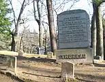 Sleepy Hollow Cemetery in Concord, Massachusetts. See the Sleepy Hollow Cemetery Sleepy Hollow Cemetery on OSM.
 -
Waverley_Cemetery-2.jpg) Waverley Cemetery in Sydney, Australia. See the Waverley Cemetery Waverley Cemetery on OSM.
Waverley Cemetery in Sydney, Australia. See the Waverley Cemetery Waverley Cemetery on OSM. -
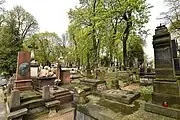 Powązki Cemetery in Warsaw, Poland. See the Powązki Cemetery Powązki Cemetery on OSM.
Possible rendering
The rendering for a historic cemetery on the standard tile layer could be the same rendering used for landuse=cemetery but in the colour tone used for historical features.


See also
- Historic cemetery - A draft proposal not finally proposed. Includes a relevant discussion on the tagging mailing list about the controversy surrounding the use of this tag.
historic=tomb- To map a specific tomb on the cemetery grounds.