Tag:landuse=construction
 |
| Description |
|---|
| An area being built on. |
| Rendering in OSM Carto |

|
| Group: lifecycle |
| Used on these elements |
| Useful combination |
|
| See also |
| Status: approved |
| Tools for this tag |
|
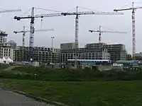
An area of land being built on.
How to map
Map an outline of the land being built ![]() and add
and add landuse=.
Additional tags
Recommended:
check_date=*– the date when construction was last seen here. This tag will allow to find old, completed constructionsname=*– name of the construction site
Optional:
image=*– imageopening_date=*– the expected date of completion of construction. Often found on the construction boardconstruction=*– the kind of construction, usually what thelanduse=*tag should be when the construction is completeoperator=*– construction company namestart_date=*– construction start date
If applicable:
website=*– website
Tags on additional objects
building=constructionto map single buildings which are under construction. Usually you would uselanduse=to tag the whole construction area, which is generally bigger than the building outline(s), and create new, separate objects for the under-construction buildings with this tag.
Nodes
As with many other tag such as building=* or landuse=cemetery mapping such features as areas is highly preferable. But in some cases one may be able to mark location of a construction site but unable to mark its area.
Similar/alternative tags
landuse=greenfield- Land scheduled for new development where there have been no buildings before. A greenfield site is scheduled to turn into a construction site at some point in the future, though the timing may be unclearlanduse=brownfield- Brownfield is a land which was previously developed which is not currently in use- Proposed features/Wasteland - Past tag proposal for land not used for anything - not maintained or with any planned use.
See also
highway=construction- A highway (road, track or path) currently under construction- Original proposal for this tag