Tag:landuse=flowerbed
 |
| Description |
|---|
| An area designated for flowers. |
| Rendering in OSM Carto |

|
| Group: landuse |
| Used on these elements |
| Useful combination |
| See also |
| Status: de facto |
| Tools for this tag |
|
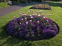
The tag landuse= is used to map land used for flowerbeds, an area used to grow decorative flowers. Often these features are found within a leisure=park or leisure=garden.
Land for flowerbeds mapped with this tag should typically be at ground level (ignoring any undulations in the absolute level due to uneven ground). If the area is a raised structure with a border made from a different material, used to contain plants the tag man_made=planter should be used instead.
Tags used in combination
surface=*– can be used to show the surface of the top level of filling in the flowerbed (below any plants/flowers).
See also
man_made=flowerbeda tag to map individual flowerbeds (as opposed to mapping land used for flowerbeds)man_made=planter– A raised structure for planting flowers or other ornamental plantsleisure=garden– A place where flowers and other plants are grown in a decorative and structured manner or for scientific purposesgarden:style=flower_garden– A type of garden where flowers are grown and displayedlanduse=greenery– Used for vegetation that is hard to classify, but less informativelanduse=plant_nursery– Represents land that is used solely for plant nurseries, which grow live plants for salelanduse=farmland– Area of farmland used mainly for tillage (annual crops)