Tag:parking=layby
 |
| Description |
|---|
| Parking at a rest area, alongside a road. There is usually no physical barrier between the road and the layby. If there is then consider using rest-area. |
| Group: parking |
| Used on these elements |
| Requires |
| See also |
| Status: de facto |
| Tools for this tag |
|
A lay-by (a term used in the British Isles) or rest-area alongside a road or sometimes simply the old section of road left over when the road was straightened. There is often no physical barrier between the road and the lay-by. If there is then consider using highway=rest_area instead.
Lay-bys sit roughly between emergency bays and rest areas in terms of use. They are suitable places for fatigued drivers or travellers in need of a quick stop (e.g., wagon sickness, need to consult a map, etc.), and as such are important features on maps geared towards motorists. Unlike highway=emergency_bay their use is not restricted to emergencies, but unlike highway=rest_area, they tend to lack amenities such as rubbish bins or picnic tables.
Difference with street-side parking
A parking= can have the same physical appearance as parking=street_side when it is just a parking bay off the side of a road. Whether such a bay is a lay-by or just ordinary street-side parking may be determined by taking these characteristics into account:
- Is the location of the parking isolated and well outside of built-up areas?
- Is the classification of the road one of relatively high importance for the road network, or is the road a long through-route with few other possibilities for taking a break along the way?
- Are there no sidewalks or other paths leading to and from the parking?
- Are there no points of interest for which this is a common or designated parking spot?
If the answer to all of the above is 'yes', this is most likely a lay-by, but the boundary between the two is not set in stone. Another characteristic is that most motorists typically won't leave their car unattended in a lay-by, as you would on a normal parking lot or with street-side parking.
Difference with emergency bays
Both highway=emergency_bay and parking= can have the exact same physical characteristics of a bay along a major road. The difference is in the allowed use. Emergency bays are for emergencies only, and tend to be signed with a traffic sign indicating this (see highway=emergency_bay for a representative list). Lay-bys will lack this sign, and may be signed with the usual P traffic sign instead.
Example photos
-
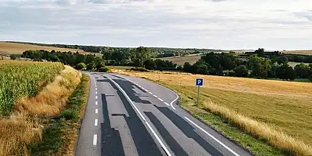
 A174, United Kingdom
 -
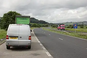 A629, United Kingdom
 -
N2, France
-
 DK24, Poland
 -
_in_Falkensteig.jpg) B 31, Germany
B 31, Germany -
 A479, United Kingdom
How to map
Map as documented on amenity=parking, and add the parking=.
For larger rest-areas separated from the main road with its own service roads and other facilities, consider using highway=rest_area instead, and map the parking facilities there with parking=surface (when taken as one large area) or parking=street_side (when mapped as separate bays off the service roads there).
Parking is most often, if not always, parallel to the road (orientation=parallel).
When not to use
Due to a lack of documentation this tag has been misused in the past for some types of street-side parking. For parking along streets in a built-up area, consider the street parking scheme and/or parking=street_side instead.
See also
parking=street_sidefor parking area directly adjacent to the carriageway of a roadhighway=servicesfor rest areas that sell fuelhighway=rest_areafor rest areas that don't sell fuel. Also known as a 'turnout' (US).highway=passing_placefor widening on a road allowing oncoming vehicles to pass each other, or allowing slower vehicle to halt so faster traffic can pass ithighway=emergency_bayfor an area beside a highway where you can safely stop your car in case of breakdown or emergencyshoulder=*- shoulders, also known as breakdown lanes, often serves as an emergency stopping lanes