Tag:place=plot
 |
| Description |
|---|
| A named plot is a tract or parcel of land owned or meant to be owned by some owner. |
| Group: places |
| Used on these elements |
| Useful combination |
|
| See also |
| Status: in use |
| Tools for this tag |
|
Definition
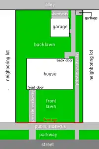
Use the tag place= to identify a named plot is a tract or parcel of land owned or meant to be owned by some owner.
place= is a subdivision at a level lower than place=neighbourhood or place=city_block.
place= is presently the lowest level of urban division in the place=* hierarchy.
According to Wikipedia's ![]() land lot, a plot is also known as a lot.
land lot, a plot is also known as a lot.
As any other OpenStreetMap object, a plot's boundaries are recorded by visual observation on the ground - so they do not necessarily match cadastral records, although Openstreetmap's plot does have some degree of kinship with its more administrative cousin, the cadastral plot.
Usage
place= is preferably used to tag an area.
Use name=* to record the plot's common name.
A plot's boundary is often materialized by a barrier=* such as barrier=wall or barrier=fence
Examples in Openstreetmap
- Plot in a Jordanian refugee camp, according to the scheme defined by UNCHR
- "Mama Muga's Plot" in Kibera, example illustrative of plots in urban Africa
Examples in the wild
West Africa
These images from Senegal show how each block is subdivided into land plots - each with a courtyard and several buildings that usually all belong to an extended family, often surrounded by a barrier=wall :
-
 Example 1
 -
 Example 2
Possible synonyms
See also
- Land_lot on Wikipedia.
place=neighbourhoodplace=city_blockplace=townplace=city