Tag:seamark:distance_mark:units=kilometres
 |
| Description |
|---|
| Used for a kilometer stone along a waterway. |
| Group: marine navigation |
| Used on these elements |
| Requires |
| Useful combination |
| Status: in use |
| Tools for this tag |
|
Used for a kilometer stone along a waterway.
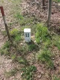
How to map
For the virtual kilometer point in the river
Place a point ![]() directly on the way
directly on the way ![]() that represents the waterway and add the following:
that represents the waterway and add the following:
seamark:type=distance_mark- OpenSeaMap/Distance_Marksseamark:distance_mark:category=not_installed- virtual river kilometerseamark:distance_mark:distance=numberseamark:distance_mark:units=
For the pole/board on the shore
To map the shield, draw a node ![]() and add the following:
and add the following:
seamark:type=distance_mark- OpenSeaMap/Distance_Marksseamark:distance_mark:category=pole/board/unknown_shapeseamark:distance_mark:distance=numberseamark:distance_mark:units=
Rendering auf OpenSeaMap
The black circles are the milestones or the hectometer stone (hm1), the colored circles are the virtual kilometer points.