Tag:source:height=shadow
 |
| Description |
|---|
| Height information obtained by shadow calculation. |
| Group: annotations |
| Used on these elements |
| Useful combination |
|
| Status: in use |
| Tools for this tag |
|
Shadow can be use to have height estimation.
For example, height can be estimate with online website (like https://www.suncalc.org) on satellite imagery, by knowing the date of a capture (very useful with Esri combined with Esri World Imagery Wayback, where the capture date can be found by clicking on an image).
Example
- Height of communication tower in North Korea based on SunCalc (combined with Esri World Imagery Wayback).
Image
-
 Long shadow of a dead tree with its branches on the dry fields of Don Det (Si Phan Don, Laos), a sunny day with blue sky and white clouds, late afternoon
 -
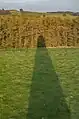
 Shadow of a building
 -
 Shadow of The Ducket
 -
Shadow cast by monument on Tennyson Down, Isle of Wight, UK