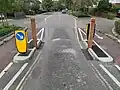
Tag:traffic_calming=choker
 |
| Description |
|---|
| Deliberately narrowed road sometimes signed as pinch points. |
| Group: highways |
| Used on these elements |
| See also |
| Status: approved |
| Tools for this tag |
|
A choker is a narrowed point along a road, generally reducing traffic to a single lane, deliberately designed to slow down or discourage motor vehicle traffic. Chokers can also be called 'pinch points' or 'slow points'.
How to map
This can be mapped as a node on a highway=* way. Optionally, the length of the choker can be mapped by splitting the highway=* way and adding traffic_calming= to the section of the way where the choker is located.
A choker can be used in combination with a pedestrian crossing.
Other traffic calming features can be used with a choker, such as a speed cushion. You can specify this like: traffic_calming=choker;cushion
Tags used in combination
priority=*-Specifies whether one direction of traffic has priority over another side which needs to give way (yield). If no direction has priority, leave this key blank.bicycle_bypass=*- Specifies if there is a bypass of the choker for bicycles on one or more sides. For information in correct usage, refer to the wiki page.maxspeed:advisory=*- Specifies if there is an advisory maximum speed for the chokermaxwidth=*- Maximum legally permitted width of vehicle allowed to pass through (if indicated on a road sign)maxwidth:physical=*– Maximum actual width of a vehicle that can pass through safely- (more rarely)
width=*– Actual width of the way's surface