Thetford
| V・T・E |
| latitude: 52.41441, longitude: 0.74663 |
| Browse map of Thetford 52°24′51.88″ N, 0°44′47.87″ E |
| Edit map |
|
External links:
|
| Use this template for your locality |
Thetford is a town in Norfolk at latitude 52°24′51.88″ North, longitude 0°44′47.87″ East.
OSM Coverage
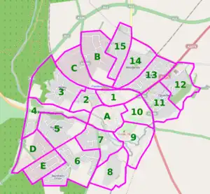
See Template:En:Map_status for an explanation of what the symbols and colours mean.
Residential Areas
| Slice | Name | Status | Remarks | Mapped/checked by |
|---|---|---|---|---|
| 1 | Vicarage Road area | |||
| 2 | Monksgate / Abbeygate | |||
| 3 | Abbey Farm | |||
| 4 | Maine St / Coney Cl / Cannon's Cl | |||
| 5 | Redcastle Furze | |||
| 6 | Barnham Cross | |||
| 7 | Mill / Newtown | |||
| 8 | Nunnery | |||
| 9 | Castle / Arlington Way | |||
| 10 | Redgate / Green Lane area | |||
| 11 | Cloverfields | |||
| 12 | Kilverstone Park | |||
| 13 | Admirals | |||
| 14 | Woodlands | |||
| 15 | Ladies |
Commercial / Industrial Areas
| Slice | Name | Status | Remarks | Mapped/checked by |
|---|---|---|---|---|
| A | Town Centre | |||
| B | Fison Way | |||
| C | Brunel Way | |||
| D | Caxton Way & Forest Retail Park | |||
| E | Burrell Way |
Public Transport
Rail
- Breckland Line
 Breckland Line
 - Thetford Station
 Thetford Station
Bus
- Thetford Bus Interchange Thetford Bus Interchange
- CS 40: Thetford - Brandon / Mundford - Kings Lynn / Downham Market CS 40: Thetford - Brandon / Mundford - Kings Lynn / Downham Market
- CS 81: Thetford - Watton CS 81: Thetford - Watton
- CS 84: Thetford - Bury St Edmunds CS 84: Thetford - Bury St Edmunds
- CS 86
- CS 332: Thetford - Honington - Bury St Edmunds CS 332: Thetford - Honington - Bury St Edmunds
- CS 201: Thetford - Brandon - Mildenhall CS 201: Thetford - Brandon - Mildenhall
- SIM 77
- SIM 191
- 490: Thetford - Norwich - London 490: Thetford - Norwich - London
- 727: Norwich to Stansted, Heathrow & Gatwick Airports 727: Norwich to Stansted, Heathrow & Gatwick Airports
Nearby Cycling and Walking Routes
Town Trails
- Thetford Heritage Trail Thetford Heritage Trail
- Thomas Paine Trail
- Dad's Army Trail
Long Distance Paths
- Angles Way Thetford Link Angles Way Thetford Link
- Hereward Way Hereward Way
- Iceni Way
- St Edmund Way St Edmund Way
- Little Ouse Path Little Ouse Path
- Peddars Way Peddars Way
- Peddars Way Bridle Route Peddars Way Bridle Route
- Icknield Way Path Icknield Way Path
- Icknield Way Trail Icknield Way Trail