Trip4YouMaps
| Trip4YouMaps | ||||||||||||||||||||||||||||||||||||||||||||||||||||||||||||||||||||||||||||||||||||||||||||||||||||||||
|---|---|---|---|---|---|---|---|---|---|---|---|---|---|---|---|---|---|---|---|---|---|---|---|---|---|---|---|---|---|---|---|---|---|---|---|---|---|---|---|---|---|---|---|---|---|---|---|---|---|---|---|---|---|---|---|---|---|---|---|---|---|---|---|---|---|---|---|---|---|---|---|---|---|---|---|---|---|---|---|---|---|---|---|---|---|---|---|---|---|---|---|---|---|---|---|---|---|---|---|---|---|---|---|---|
 | ||||||||||||||||||||||||||||||||||||||||||||||||||||||||||||||||||||||||||||||||||||||||||||||||||||||||
| Author: | Gerhard Rock | |||||||||||||||||||||||||||||||||||||||||||||||||||||||||||||||||||||||||||||||||||||||||||||||||||||||
| License: | Proprietary | |||||||||||||||||||||||||||||||||||||||||||||||||||||||||||||||||||||||||||||||||||||||||||||||||||||||
| Platforms: | Web, Android, and iOS | |||||||||||||||||||||||||||||||||||||||||||||||||||||||||||||||||||||||||||||||||||||||||||||||||||||||
| Status: | Active | |||||||||||||||||||||||||||||||||||||||||||||||||||||||||||||||||||||||||||||||||||||||||||||||||||||||
| Version: | (2025-06-17) | |||||||||||||||||||||||||||||||||||||||||||||||||||||||||||||||||||||||||||||||||||||||||||||||||||||||
| Languages: | English and German
| |||||||||||||||||||||||||||||||||||||||||||||||||||||||||||||||||||||||||||||||||||||||||||||||||||||||
| Website: | https://maps.trip4you.net | |||||||||||||||||||||||||||||||||||||||||||||||||||||||||||||||||||||||||||||||||||||||||||||||||||||||
|
App for Route planning, Navigation & Tracking. |
||||||||||||||||||||||||||||||||||||||||||||||||||||||||||||||||||||||||||||||||||||||||||||||||||||||||
| ||||||||||||||||||||||||||||||||||||||||||||||||||||||||||||||||||||||||||||||||||||||||||||||||||||||||
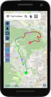
Trip4YouMaps (maps.trip4You.net) is a Progressive Web App (Web, Android & iOS) for route planning, navigation & tracking - optimised for outdoor activities.
Trip4You uses the OSM data and is particularly suitable for bike tours. Routes can be planed for the moving profiles standard bike, e-bike, road-bike, MTB, walking, hiking and car. Additionally to the OSM-map you can select other maps with special outdoor information. Planned routes can be shared or saved in the local stoarge of the device or in the cloud. Trip4YouMaps can be installed by the browser, updates come automatically. A very important feature is to show the route surfaces on an elevation profile and directly on the map. Extern routes in the format of gpx-files can be loaded and tracking is possible. Sharing of location and live-tracking are available. Search routes by filter options and map extent.
Trip4YouMaps-Features
Route planning
- Different moving profiles (bike, e-bike, road-bike, MTB, walking, hiking, car)
- Easy waypoint definition (search, click on map, select from saved places)
- Up to 50 waypoints possible
- Order change of waypoints by Drag & Drop, interactive insert of waypoints
- Option for roundtrip (back to startpoint)
- Bike options (avoid stairs)
- Car options (avoid tollways, avoid highways)
- Special planning for round trips (with start point, length and options)
- Route details (statistics, elevation profile, way surface, way type, inline/decline, turn-by-turn guidance)
- Show way surface, way type, incline/decline also on the map
- Reverse route
- Share route (plan route on desktop and send it to friends or your own mobile device)
- Save route in local storage or in the cloud
- Add POIs to planned route
- Export route as gpx-file
- Plan a seperate route to the start point (with Trip4You-Maps or Google-Maps)
- Turn-by-turn guidance
- Estimted remaining duration
- Estimated arrival
- Off the route signal (Warning if you are off the route)
- Automatic map move & rotation (selectable in settings)
Maps/Monitoring
- Different maps selectable
- OSM (standard OpenStreetMap - many details)
- MapTiler Outdoor (with Hiking- and cycling routes)
- MapTiler Topo (with isolines of elevation)
- MapTiler Satellite (satellite-map)
- CycleOSM ( specific bke-map)
- Overlay maps with hiking and cycling & MTB reds (waymarked routes)
- Show restaurants, accomodations, groceries and other POIS (details with popup)
- Show way surface, way types, incline/decline on map
Additional features
- Import gpx-file (show details)
- Import kml-file (show details)
- Tracking (show details, export track as gpx-file)
- Share your location or share a link for live tracking
- Organise saved routes and points in lists
- Create & share map markers
- Publish your route for other users
Embedding on other websites (using IFrame)
- Embedding in tourism websites to present hiking or cycling routes
- Embedding in company websites (as a way to get there)
External Links & References
- maps.trip4you.net - Link to App Trip4YouMaps
- maps.trip4you.net/infos - Infos about Trip4YouMaps (About, FAQ, Privacy policy, Terms of use, Contact)
See also
- OSM-Wiki - Comparison of Android applications
- OSM-Wiki - Comparison of iOS applications