| uNav
|
|
|
| Authors:
|
Costales, JkB, Nekhelesh, Olivier Tilloy, Dan Chapman
|
| License:
|
GNU GPL v3 (free of charge)
|
| Platform:
|
Ubuntu Touch
|
| Version:
|
0.64 (2016-09-19)
|
| Languages:
|
English, Asturian, Basque, Bosnian, Breton, Catalan, Simplified Chinese, Traditional Chinese, Dutch, Finnish, French, Scottish Gaelic, Galician, German, Greek, Hungarian, Italian, Norwegian, Polish, Portuguese, Romanian, Russian, Sardinian, Serbian, Slovak, Slovenian, Spanish, Swedish, Turkish, and Ukrainian
|
| Website:
|
http://unav.me
|
| Source code:
|
Launchpad
|
|
Map viewer and GPS navigator for Ubuntu Phone
|
|
Features
| Feature
|
Value
|
| Map Display
|
| Display map
|
yes
|
| Map data
|
raster
|
| Source
|
online
|
| Rotate map
|
yes
|
| 3D view
|
no
navi related----
|
| Shows website
|
?
|
| Shows phone number
|
?
|
| Shows operation hours
|
?
|
| Routing
|
| Routing
|
yes
map display related----
|
| Create route manually
|
?
|
| Calculate route
|
yes
|
| Create route via Waypoints
|
?
|
| Routing profiles
|
car;bike;foot
|
| Turn restrictions
|
yes
|
| Calculate route without Internet (Offline routing)
|
no
|
| Routing providers
|
Mapzen
|
| Avoid traffic
|
?
|
| Traffic Provider
|
?
|
| Navigating
|
| Navigate
|
yes
|
| Find location
|
yes
|
| Find nearby POIs
|
yes
|
| Navigate to point
|
yes
|
| Navigation with voice / Voice guidance
|
yes
|
| Keep on road
|
yes
|
| Lane guidance
|
?
|
| Works without GPS
|
yes
|
| Navigate along predefined route
|
no
|
| Tracking
|
| Make track
|
no
|
| Customizable log interval
|
?
|
| Track formats
|
?
|
| Geotagging
|
?
|
| Fast POI buttons
|
?
|
| Upload GPX to OSM
|
?
|
| Monitoring
|
| Monitoring
|
no
|
| Show current track
|
?
|
| Open existing track
|
?
|
| Altitude diagram
|
?
|
| Show POD value
|
?
|
| Satellite view
|
?
|
| Show live NMEA data
|
?
|
| Show speed
|
?
|
| Send current position
|
?
|
| Editing
?
|
| Rendering
?
|
| Accessibility
?
|
|
|
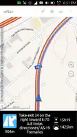
 uNav is a map viewer and navigation application for Ubuntu Phone.
Features
- Online and offline map viewer and GPS navigator.
- Powered by OpenStreetMap & Mapzen.
- Car, bike, walk & public transport modes.
- Avoid tolls.
- Speed camera alerts.
- Searches & Nearby POIs powered by OpenStreetMap.
- Share positions & catch those positions (even geo URIs).
- For any country in the world.
- 100% GPL and 100% powered by libre projects.
- turn-by-turn indicators with voice.
- Unit: kilometers or miles.
Links