WebOS
This page describes OSM software running on Hewlett Packard's WebOS.
General
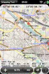
| Name | MapTool | MojoTracker | Navit |
|---|---|---|---|
|
| ||
| Website | Website | Website, F-Droid, Google Play | |
| Genre | Display | Logger | Navi, Logger, Router |
| Description | ?
|
?
|
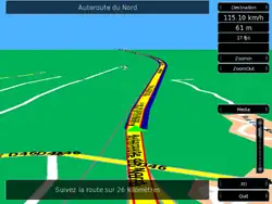
Most popular open source car navigation tool; maps (offline-"custom"), vector-rendered. |
| Supported platforms | WebOS | WebOS | Android, Linux, WebOS, Windows, n800, zaurus |
| Release date | ?
|
2010-11-13 | 2021-03-06 |
| Languages | English | English | Mehrsprachig |
| Author | MetaViewSoft | MojoTracker Team | ?
|
| Price | ?
|
?
|
free of charge |
| License | free | BSD | GPLv2 |
| Source code | ?
|
</> | </> |
This table was generated by the OSM Apps Catalog at 2024-01-06.
Map display
| Name | MapTool | Navit |
|---|---|---|
| Display map | yes | yes |
| Map data | Raster | Vector |
| Source | Online, Cache | Offline |
| Rotate map | no | yes |
| 3D view | no | yes |
This table was generated by the OSM Apps Catalog at 2024-01-06.
Routing
| Name | Navit |
|---|---|
| Routing | yes |
| Calculate route | yes |
| Routing profiles | Car, Foot |
| Turn restrictions | yes |
| Calculate route without Internet (Offline routing) | yes |
| Routing providers | Offline |
This table was generated by the OSM Apps Catalog at 2024-01-06.
| Name | MapTool | Navit |
|---|---|---|
| Navigate | no | yes |
| Find location | no | yes |
| Find nearby POIs | no | yes |
| Navigate to point | yes | yes |
| Navigation with voice / Voice guidance | no | yes |
| Keep on road | no | yes |
This table was generated by the OSM Apps Catalog at 2024-01-06.
Tracking
| Name | MapTool | MojoTracker | Navit |
|---|---|---|---|
| Make track | no | yes | yes |
| Customizable log interval | yes | no | ?
|
| Track formats | Gpx | Gpx, Kml | Bin, Garmin, Gpx, Nmea |
| Geotagging | no | Photo | ?
|
| Upload GPX to OSM | yes | no | ?
|
This table was generated by the OSM Apps Catalog at 2024-01-06.
Monitoring
| Name | MapTool | MojoTracker | Navit |
|---|---|---|---|
| Monitoring | yes | yes | yes |
| Show current track | yes | no | yes |
| Open existing track | yes | no | ?
|
| Altitude diagram | no | yes | no |
| Show POD value | yes | yes | yes |
| Send current position | Sms, Www | no | no |
This table was generated by the OSM Apps Catalog at 2024-01-06.