JA:Tag:tourism=information
 |
| 説明 |
|---|
| 旅行者や訪問者向けの案内、案内所も含む |
| グループ: 観光 |
| 適用できる要素 |
| 依存するタグ |
| よく併用されるタグ |
|
| 状態:事実上の標準 |
| ツール |
観光客、旅行者、来訪者に情報を提供するところです。以下のものが含まれます。
- 観光案内所やビジターセンター
- 案内地図板(市街地地図、案内図、ハイキングの登山地図など)
- 観光客向けの掲示板
- 観光客に地域の歴史や野生動物などについての詳細を紹介する案内板
マッピング方法
設備の種類によって、ノード ![]() またはエリア
またはエリア ![]() を追加してください。ノードまたはエリアを
を追加してください。ノードまたはエリアを tourism= および information=* (下記参照)でタグ付けして下し。他に併用されるタグは以下の通りです。
name=*description=*
値
情報 (Information)
| キー | 値 | 要素 | 説明 | レンダリング | 写真 |
|---|---|---|---|---|---|
| information | office | 観光案内所、ビジターセンター。町や地域の情報を得られる事務所です。 |  |
 | |
| information | visitor_centre | A place where you can get information about a specific attraction or place of interest. |  | ||
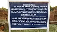
| information | board | 情報掲示板。より詳細には board_type=* を参照。
|
 |
 | |
| information | stele | A stele for information. |  | ||
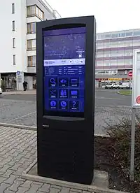
| information | terminal | 電子的な方法による情報アクセスを提供する端末。多くの場合インターネットにつながっています。 |  |
 | |
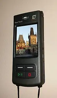
| information | audioguide | ヘッドフォンや携帯電話を使って情報を得られる場所。 |  |
 | |
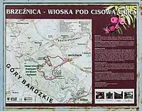
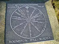
| information | map | 地図付きの掲示板。種別や表示内容を指定するためには、 map_type=*, map_size=* を参照してください。表示されたルートの対象者を示すには、 hiking=yes, bicycle=yes, ski=yes などの access キーを使用します。
|
 |
  | |
| information | tactile_map | 触知地図は全盲者向けの地図であり、また触覚地図としても知られています。 | 見える地図ではレンダリングする必要がありませんが、例えば http://blind.accessiblemaps.org や HaptoRender で使用します | 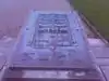 | |
| information | tactile_model | 触知モデルは全盲者向けに建物やその周辺を表したモデルです。 | 見える地図ではレンダリングする必要がありませんが、例えば http://blind.accessiblemaps.org や HaptoRender で使用します |  | |
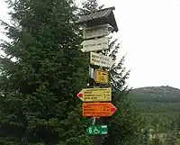
| information | guidepost | 道標、ガイドポスト。異なる目的地への方向を示すためにオフィシャルハイキング/サイクリングルート沿いにしばしば見られます。表示されたルートの対象者を示すには、 hiking=yes, bicycle=yes, ski=yes などの access キーを使用します。
|
 |
 | |
| information | post | A small pole, erected vertically, with information on the top or sides that may be inscribed, or on a small plaque. Somewhat similar to an information=stele, but smaller. | .jpg) | ||
| information |
A marker that shows the position of the way of a route. Could be a symbol, a short pole or a painted marking. Note that two partially equivalent tag values are used: a more popular |
.jpg) 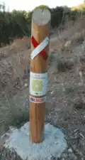 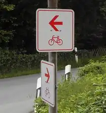 | |||
| information | user defined | Taginfo でよく使われている値を確認できます。 |
This table is a wiki template with a default description in English. Editable here.日本語版はこちら。