Key:crossing:barrier
 |
| Description |
|---|
| Type of gates on a railway level crossing. |
| Group: railways |
| Used on these elements |
| Requires |
| Useful combination |
| Status: de facto |
| Tools for this tag |
|
The tag =* is used to specify which type of gates the railway level crossing has.
How to map
Use the tag on a node ![]() . The node should be shared between the highway and railway.
. The node should be shared between the highway and railway.
railway=level_crossing/railway=crossingobligatory=*the type of gates=no- no gates=full- full-width gates=double_half- two half-width gates on each approach, barring both the entry and exit=half- a half-width gate on each approach, barring the entry but leaving the exit free=yes- gates (to use when you do not know a more precise value)
Sidewalks and cycle lanes
When the value for the roadway is half, but the sidewalks or cycle lanes have barriers on both approaches:
=full- sidewalks=full- cycle lanes
Of course, when the sidepaths are mapped as separate ![]() ways, do not use these tags. Instead, add the barrier information on their crossing nodes.
ways, do not use these tags. Instead, add the barrier information on their crossing nodes.
Tags used in combination
supervised=*- indicates whether there is a person who supervises the placecrossing:activation=*- the way of operationcrossing:activation=automatic- automatic (by contacts)crossing:activation=remote- remotely operated (by train dispatcher)crossing:activation=local- locally operated (by guard or train personal)
crossing:light=*- visual warning of crossing closurecrossing:saltire=*- diagonal cross sign (usually present)crossing:on_demand=*- on-demand operationcrossing:bell=*- audible warning of crossing closure
Examples
| Photo | key=value |
|---|---|
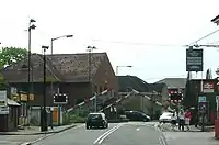
|
railway=level_crossing crossing:barrier=half crossing:light=yes crossing:saltire=yes crossing:bell=yes |
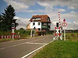
|
railway=level_crossing crossing:barrier=half crossing:barrier:footway=full crossing:bell=yes crossing:light=yes crossing:saltire=yes |
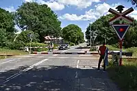
|
railway=level_crossing crossing:barrier=full crossing:light=yes crossing:saltire=yes |
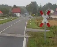
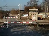
|
railway=level_crossing crossing:barrier=no crossing:saltire=yes |