Tag:amenity=hunting_stand
 |
| Description |
|---|
| An open or enclosed platform used by hunters to place themselves at an elevated height above the terrain. |
| Rendering in OSM Carto |
| Group: amenities |
| Used on these elements |
| Useful combination |
|
| Status: de facto |
| Tools for this tag |
|
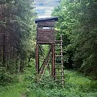
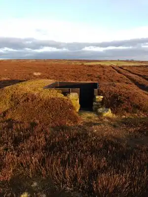
A hunting stand (or ![]() tree stand) is an open or enclosed platform used by hunters to place themselves at an elevated height above the terrain.
tree stand) is an open or enclosed platform used by hunters to place themselves at an elevated height above the terrain.
How to map
Place a node ![]() and add a tag
and add a tag amenity= to it.
Tags used in combination
shelter=yes- hunting stand has a roofheight=*- height (number without m)direction=*- field of viewhide=yes/no- enclosed stands that almost look like a shedlockable=yes- is it lockable?ladder=yes- does it have ladder? (maybe unnecessary, implied byraised=yes/no)raised=yes/no- is it raised over terrain or is it on earth level only?
Differentiation by design:
Combination of amenity= with
hunting_stand=tree_standortree=yes- hunting stand placed on a treehunting_stand=hide- hunting stand on an earth levelhunting_stand=raised_hideorraised=yes- (locked) raised enclosed hunting standhunting_stand=grouse_butt- a traditional type used for driven grouse shooting in the British Isles. Usually a semi-circular or horseshoe shaped wall made of stone or turves. It encloses the shooter and possibly a loader. Usually arranged in lines. Some less traditional designs may also be seen. NOTE: these can be mapped as ways.
Additional tags which should not be used:
blind=yes- hunting stand is masked — please use hide instead, blind collides with tagging for the blind, see OSM for the blind.lock=yes/no- hunting stand is lockable — there is a conflict withlock=*
See also
These structures are very similar or identical in construction and differ mostly by function:
leisure=bird_hide- A place that is used to observe wildlife, especially birdsleisure=wildlife_hide- A place to observe wildlife