Key:monitoring:groundwater_level
 |
| Description |
|---|
| Monitoring station for the level of groundwater. |
| Used on these elements |
| Requires |
| Useful combination |
| See also |
| Status: de facto |
| Tools for this tag |
|
=* is used to indicate if a man_made=monitoring_station measures the level of the water in the ground, typically of an aquifer or other water table. For the equivalent surface water tag see monitoring:water_level=*.
Tagging
Useful combinations
depth=*– The total depth of the monitoring well (not the depth to the groundwater itself)display:analog=yesdisplay:digital=yesrecording:manually=yesrecording:automated=yesrecording:remote=yesname=*ref=*operator=*
Examples
-
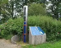
 Monitoring well head
 -
.jpg) Manual sampling of a well
Manual sampling of a well -
 Continuous monitoring well