Key:salt
 |
| Description |
|---|
| Indicates whether water is salty. |
| Group: properties |
| Used on these elements |
| Useful combination |
| Status: approved |
| Tools for this tag |
|
The tag =* is used to indicate that a water in a water body (lake, lagoon) or water way (river) is salty.
It can be used in combination with natural=water, especially with tags water=lagoon, water=lake and landuse=salt_pond.
Note: There is a vague reference to =yes at the description of the key shop=tobacco as well.
Tagging
=yes or =no
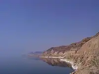
Example
natural=waterwater=lakename=Dead Sea(Dead Sea on Wikipedia)=yes