Ko:Tag:amenity=shelter
 |
| 설명 |
|---|
| 궂은 날씨를 피하기 위한 작은 시설물 |
| OSM Carto에서 렌더링 |
| 그룹: 시설 |
| 해당 요소의 사용 |
| 유용한 조합 |
| 상태:사실상 표준 |
| 이 태그를 위한 도구 |
amenity= 태그는 궂은 날씨를 피하기 위한 작은 시설물, ![]() 대피소를 매핑하는 데에 씁니다.[1]
대피소를 매핑하는 데에 씁니다.[1]
매핑 방법
Add a ![]() node or
node or ![]() area where the shelter is located, and add the
area where the shelter is located, and add the amenity= tag to it.
When hiking, people need water. Consider making sure that all streams, rivers and lakes near the shelter are also mapped.
엮어서 쓸 수 있는 태그
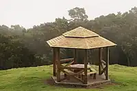
shelter_type=*- describes the type of the shelter accuratelyshelter_type=gazebo- a pavilion structure, sometimes octagonal or turret-shaped, often built in a park, garden or spacious public areashelter_type=basic_hut- contained cottage (if it has a fireplace inside then tag ittourism=wilderness_hutinstead)shelter_type=lean_to- open sheltershelter_type=picnic_shelter- A design that provides protection against rain on picnic areas.shelter_type=weather_shelter- A structure to protect from rainshelter_type=rock_shelter- A rock shelter is a shallow cave-like opening at the base of a bluff or cliffshelter_type=public_transport- Small shelters at bus stops or platforms along rail or bus routes
bench=yes— To specify if there's a bench in the shelter.bin=yes— To specify if there's a waste bin in the shelter.picnic_table=yesortable=yes— To specify if there's a table in the shelter. Note, that a table does not have benches whereas benches are attached to a picnic table.drinking_water=yes/no- Indication whether a feature provides drinking waterbuilding=*— For shelters that are buildings.building=roofis used for roofs without 4 walls.access=*— To denote legal access.lockable=yes/no— Can the shelter be locked?locked=yes/no— To describe physical access, e.g. a door is locked. This tag is currently not widely used.surface=*(orfloor:material=*) — To map the composition of the ground.surface=*appears to be the preferred tag for this, butfloor:material=*has also been used. See https://overpass-turbo.eu/s/18PK.
To map whether a feature provides shelter, the key shelter=* is used, e.g. for a bus stop, it is also possible to use highway=bus_stop + shelter=yes
Alternative rendering for bus shelter
This is a rendering proposal for your own map:

16px: ![]()
32px: ![]()
함께 보기
covered=*- A property to denote if an object is covered by somethingtourism=alpine_hut- Alpine hut, where you can eat and sleeptourism=wilderness_hut- Wilderness hut, unserviced, but with an internal fireplacebuilding=barn- An agricultural building used for storage and as a covered workplacebuilding=cabin- A small, roughly built house typically found in rural areasbuilding=hut- A small and crude shelterbuilding=shed- A small, simple structure used as storage or workshoptourism=picnic_site- A locality that is suitable for outdoors eating, with facilities to aid a picnic such as tables and benchesleisure=picnic_table- A table with benches for food and restemergency=assembly_pointmilitary=bunker
각주
- ↑ 전쟁이나 재난에 대비하는 대피소는
emergency=assembly_point나military=bunker를 보십시오.