Week 1
(2–8 Jan.)
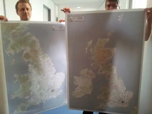
|

|
| English
|
A year of OSM - video showing editing activity during 2011
|

|
|
Week 2
(9–15 Jan2025-01-09–Error: Invalid time.)
|
|
|
Week 3
(16–22 Jan2025-01-16–Error: Invalid time.)
|
|
|
Week 4
(23–29 Jan2025-01-23–Error: Invalid time.)
|
|
|
Week 5
(30 Jan – 5 Feb2025-01-30–Error: Invalid time.)
|
|
|
Week 6
(6–12 Feb2025-02-06–Error: Invalid time.)
|
|
|
Week 7
(13–19 Feb2025-02-13–Error: Invalid time.)
|

|
|
Week 8
(20–26 Feb2025-02-20–Error: Invalid time.)
|
|
|
Week 9
(27 Feb – 4 Mar2025-02-27–Error: Invalid time.)
|
|
| English
|
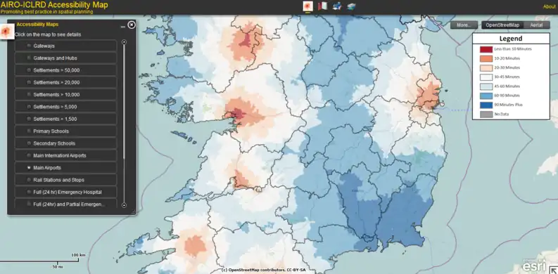
Travel-time to airports in Ireland: AIRO-ICLRD's Accessibility Map idea chooses OSM as base layer
|
|
|
Week 10
(5–11 Mar2025-03-05–Error: Invalid time.)
|
|
|
Week 11
(12–18 Mar2025-03-12–Error: Invalid time.)
|
|
|
Week 12
(19–25 Mar2025-03-19–Error: Invalid time.)
|

|
|
Week 13
(26 Mar – 1 Apr2025-03-26–Error: Invalid time.)
|
|
|
Week 14
(2–8 Apr2025-04-02–Error: Invalid time.)
|
|
|
Week 15
(9–15 Apr2025-04-09–Error: Invalid time.)
|
|
|
Week 16
(16–22 Apr2025-04-16–Error: Invalid time.)
|
|
| English
|
OSM2world gives the first slippy-map where you can rotate a 3d view.
|
|
|
Week 17
(23–29 Apr2025-04-23–Error: Invalid time.)
|
|
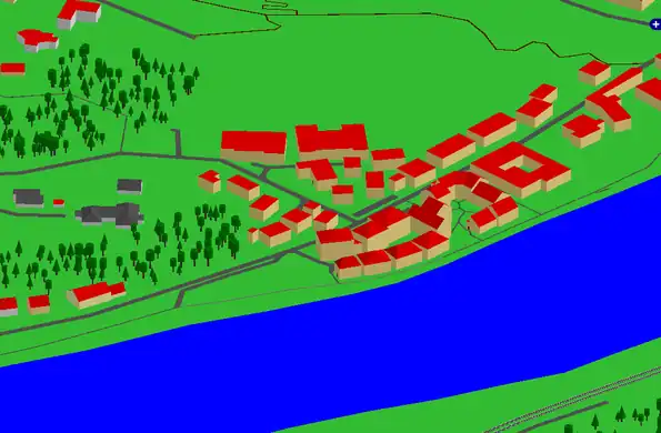
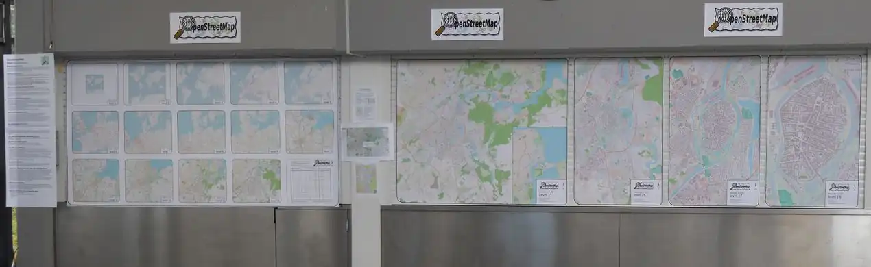
| English
|
18 zoom-levels (1:250.000.000 - 1:2.000) of Lübeck City
|
|
|
Week 18
(30 Apr – 6 May2025-04-30–Error: Invalid time.)
|

|
| English
|
On 28th of March a governor of Chelyabinsk Region, Russia was presented a city traffic management system based on OpenStreetMap. Photo ©gubernator74.ru
|
|
|
Week 19
(7–13 May2025-05-07–Error: Invalid time.)
|

|
|
Week 20
(14–20 May2025-05-14–Error: Invalid time.)
|
|
|
Week 21
(21–27 May2025-05-21–Error: Invalid time.)
|

|
|
Week 22
(28 May – 3 Jun2025-05-28–Error: Invalid time.)
|

|
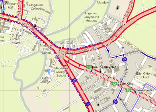
| English
|
OpenStreetMap's technology makes it easy to create fictional maps, for example Inspector Lewis' version of Oxford (at minute 55), modified to include plot-specific details
|
|
|
Week 23
(4–10 Jun2025-06-04–Error: Invalid time.)
|
|
| English
|
Land polygons created with OSMCoastline from coastlines in OSM. The polygons are split into overlapping smaller polygons to make them easier to handle.
|
|
|
Week 24
(11–17 Jun2025-06-11–Error: Invalid time.)
|
|
| English
|
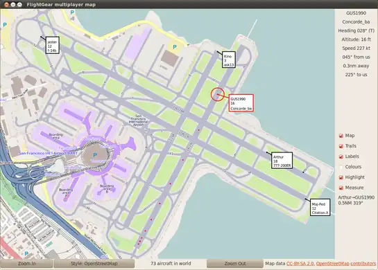
FlightGear aircraft shown over OpenStreetMap's detail of KSFO airport.
|
|
|
Week 25
(18–24 Jun2025-06-18–Error: Invalid time.)
|

|
|
Week 26
(25 Jun – 1 Jul2025-06-25–Error: Invalid time.)
|
|
|
Week 27
(2–8 Jul2025-07-02–Error: Invalid time.)
|
|
| English
|
Cycle maps of the UK
|
|
|
Week 28
(9–15 Jul2025-07-09–Error: Invalid time.)
|
|
|
Week 29
(16–22 Jul2025-07-16–Error: Invalid time.)
|

|
| English
|
Maps copied onto shoes (by tracing over a projector image) [2]
|
|
|
Week 30
(23–29 Jul2025-07-23–Error: Invalid time.)
|

|
| English
|
Redaction bot progress map [3] at the start of the week. Yellow squares were in progress on Monday. Green squares are complete. Red squares had errors and will be re-run.
|
|
|
Week 31
(30 Jul – 5 Aug2025-07-30–Error: Invalid time.)
|
|
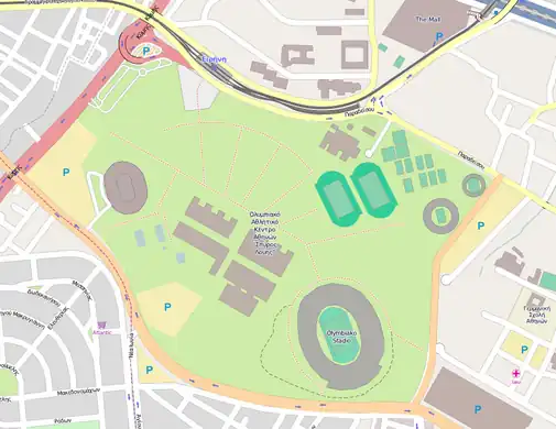
| English
|
The Olympic stadium, in east London, hosting the XXX Olympics games.
|
|
|
Week 32
(6–12 Aug2025-08-06–Error: Invalid time.)
|
|
|
Week 33
(13–19 Aug2025-08-13–Error: Invalid time.)
|

|
|
Week 34
(20–26 Aug2025-08-20–Error: Invalid time.)
|

|
| English
|
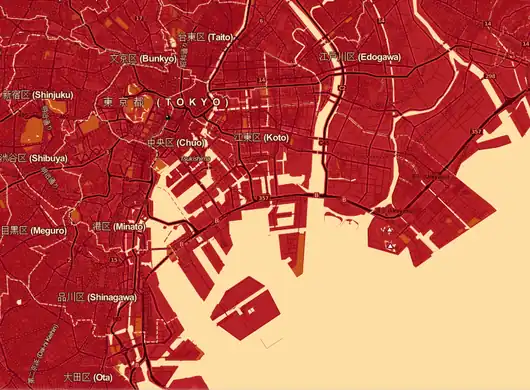
OSM user Ikiya has created another delicious map cake to celebrate OSM 8th birthday in Fukushima Japan. This cake recreates the SotM 2012 logo. SotM 2012 will be held in Tokyo Japan, in just a few days!
|
|
|
Week 35
(27 Aug – 2 Sep2025-08-27–Error: Invalid time.)
|

|
|
Week 36
(3–9 Sep2025-09-03–Error: Invalid time.)
|

|
|
Week 37
(10–16 Sep2025-09-10–Error: Invalid time.)
|

|
|
Week 38
(17–23 Sep2025-09-17–Error: Invalid time.)
|
|
| English
|
Visualization of the Planet.gpx dump with some commentary.
|
|
|
Week 39
(24–30 Sep2025-09-24–Error: Invalid time.)
|
|
| English
|
Apple showing possibly OSM on their new map application on iOS 6.
|
|
|
Week 40
(1–7 Oct2025-10-01–Error: Invalid time.)
|
|
| English
|
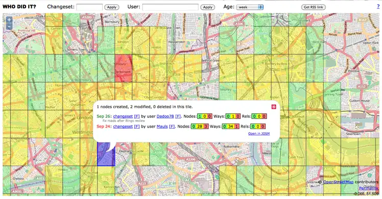
A screenshot of the WhoDidIt tool over London.
|
|
|
Week 41
(8–14 Oct2025-10-08–Error: Invalid time.)
|

|
|
Week 42
(15–21 Oct2025-10-15–Error: Invalid time.)
|
|
| English
|
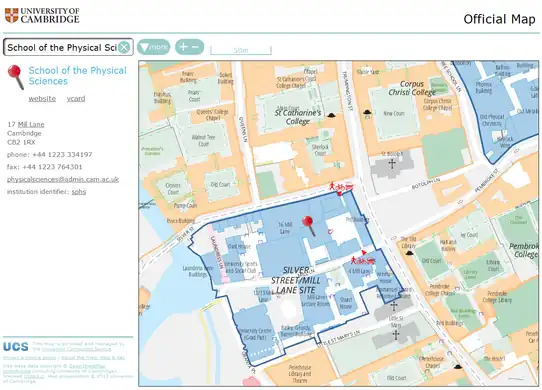
The University of Cambridge's new online map was made live at http://map.cam.ac.uk in late September 2012 (and also linked from the University's home page). This prestigious, year-long project has contributed lots of data to OSM and uses OSM data for its street index and custom renderings. More...
|
|
|
Week 43
(22–28 Oct2025-10-22–Error: Invalid time.)
|
|
|
Week 44
(29 Oct – 4 Nov2025-10-29–Error: Invalid time.)
|
|
| English
|
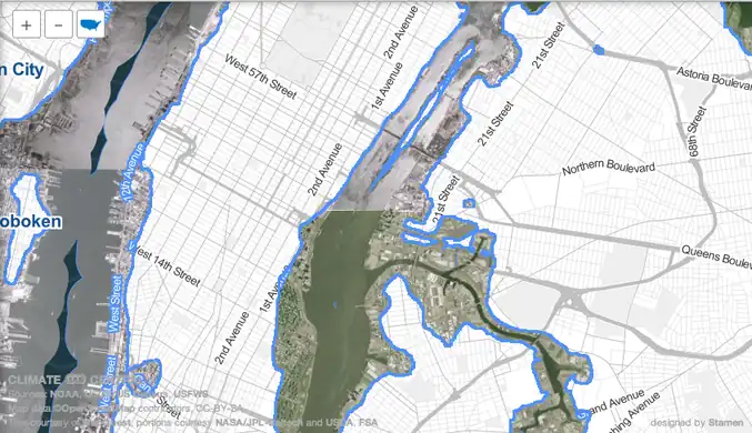
The "Surging Seas" map blends OpenStreetMap and aerial imagery to interactively simulate sea level rise due to climate change. Here we see New York after a 10ft rise, the maximum setting. The storm surge of Hurricane Sandy brought a rise of up to 13ft.
|
|
|
Week 45
(5–11 Nov2025-11-05–Error: Invalid time.)
|

|
| English
|
Trevor Dhu from AusAID demonstrates flood impact in Jakarta with InaSAFE to President Susilo Bambang Yudhoyono at the 5th Asian Ministerial Conference on Disaster Risk Reduction . One of the key sets of information used in the analysis is OpenStreetMap data
|
|
|
Week 46
(12–18 Nov2025-11-12–Error: Invalid time.)
|
|
| English
|
The NoName map has been re-launched, showing an up-to-date view of where OpenStreetMap roads have no name
|
|
|
Week 47
(19–25 Nov2025-11-19–Error: Invalid time.)
|
|
| English
|
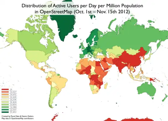
Pascal Neis and Dennis Zielstra have come up with some wonderful statistics showing the distribution of the OSM contributors relative to population.
|
|
|
Week 48
(26 Nov – 2 Dec2025-11-26–Error: Invalid time.)
|
|
| English
|
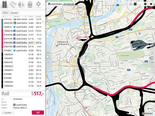
A new game called Train Lord is using OSM for worldwide rail network coverage.
|
|
|
Week 49
(3–9 Dec2025-12-03–Error: Invalid time.)
|

|
| English
|
Pedestrian Map for Cubbon park, Bangalore, created as part of a class project at NID. Students developed a system of navigation and wayfinding for visitors to the park. Data was collected using Walking Papers, added to OpenStreetMap, and then exported and processed in Adobe Illustrator for the final output.
|
|
|
Week 50
(10–16 Dec2025-12-10–Error: Invalid time.)
|

|
|
Week 51
(17–23 Dec2025-12-17–Error: Invalid time.)
|

|
| English
|
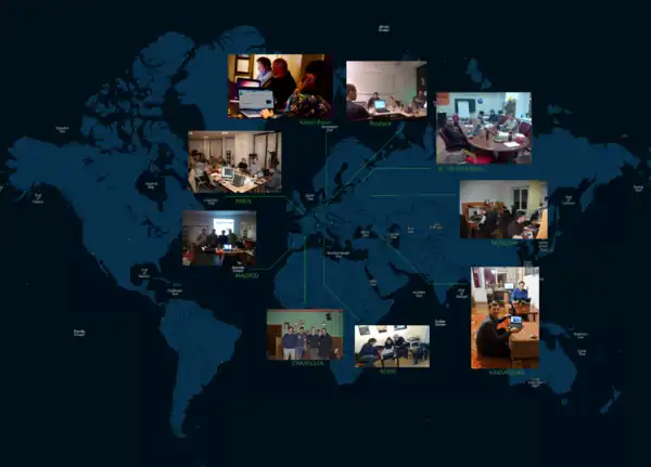
Students and teachers from five countries meet in Saarburg, Germany to learn how to gather data, use mapping devices, feed in and maintain the OSM data. Meetings in Portugal, Slovenia, Romania and Turkey will follow as part of this two year EU funded Comenius project
|
|
|
Week 52
(24–30 Dec.)
|
|
|
