Week 1
(31 Dec. – 6 Jan.)
|
|
|
Week 2
(7–13 Jan2025-01-07–Error: Invalid time.)
|
|
| English
|
Frame from the video "Year of edits 2012". This year's video features yellow and green effects for the redaction bot processing, and license changeover.
|

|
|
Week 3
(14–20 Jan2025-01-14–Error: Invalid time.)
|
|
| English
|
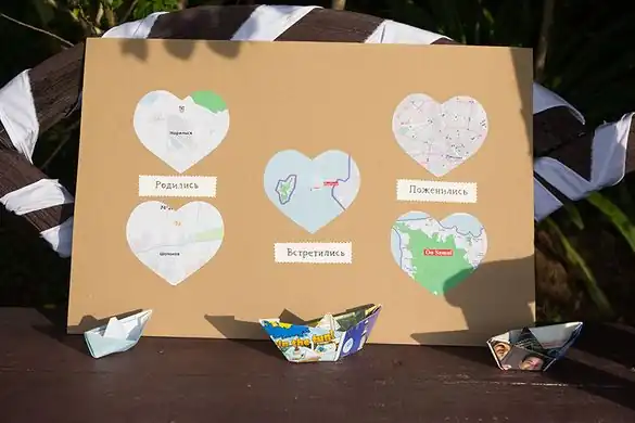
OpenStreetMap wedding decorations! At the wedding of User:Vlish he featured this poster showing where he and his wife were born, where they met, and where they married.
|
|
|
Week 4
(21–27 Jan2025-01-21–Error: Invalid time.)
|

|
| English
|
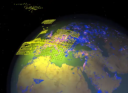
Taginfo shows what tags are used in the OSM database.
|
|
|
Week 5
(28 Jan – 3 Feb2025-01-28–Error: Invalid time.)
|
|
| English
|
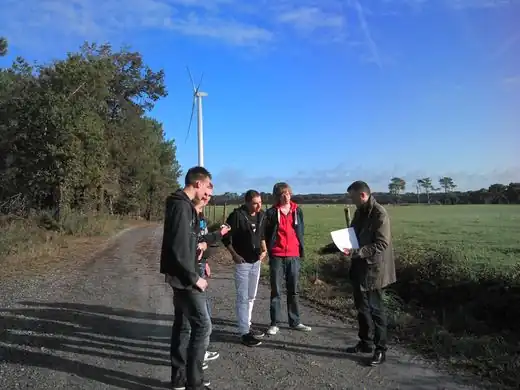
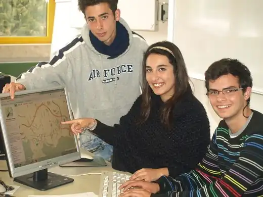
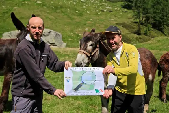
French mapping company GéoBretagne use OpenStreetMap and are working with high schools to contribute data to the project. Here we see teachers and students mapping the exact coordinates of Lauzach wind turbines and their access roads.
|
|
|
Week 6
(4–10 Feb2025-02-04–Error: Invalid time.)
|
|
|
Week 7
(11–17 Feb2025-02-11–Error: Invalid time.)
|

|
| English
|
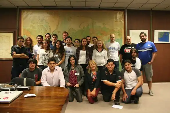
Life Long Learning Mapping Project : Şeyma, Kader, Neslihan,(teachers: Manfred, Miray) Simge, Özge, Our project aims to tackle the issue of gender-stereotyping. Students from Karacabey, Turkey, learning how to use a tracking device (Garmin) to improve OSM in Turkey.
|
|
|
Week 8
(18–24 Feb2025-02-18–Error: Invalid time.)
|

|
|
Week 9
(25 Feb – 3 Mar2025-02-25–Error: Invalid time.)
|

|
| English
|
A stack of prints at the Karlsruhe Hack Weekend in February 2013, where 18 mappers from all over Europe spent two days at the Geofabrik office, working together on OpenStreetMap projects.
|
|
|
Week 10
(4–10 Mar2025-03-04–Error: Invalid time.)
|
|
| English
|
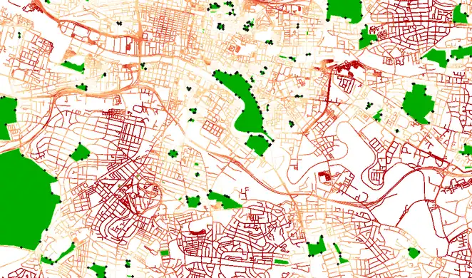
Map showing distance from parks in Glasgow, using openstreetmap data and GRASS/QGIS network analysis. Dark red means further away from a park.
|
|
|
Week 11
(11–17 Mar2025-03-11–Error: Invalid time.)
|

|
|
Week 12
(18–24 Mar2025-03-18–Error: Invalid time.)
|
|
|
Week 13
(25–31 Mar2025-03-25–Error: Invalid time.)
|
|
| English
|
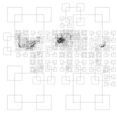
This curious map of the world, shows the result of dividing the OpenStreetMap dataset into quarters until each of these vector tiles is less than 32MB in size. An experiment by Eric Fischer (details)
|
|
|
Week 14
(1–7 Apr2025-04-01–Error: Invalid time.)
|

|
|
Week 15
(8–14 Apr2025-04-08–Error: Invalid time.)
|
|
| English
|
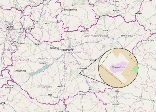
Magyarkert ("HungarianGarden") is a leisure park in Hungary, shaped like the country at a 1:1000 size ratio. It includes main rivers, lakes and shapes of hills. The park's main theme is environment protection, educational programs, sport, etc, and of course it's on OpenStreetMap.
|
|
|
Week 16
(15–21 Apr2025-04-15–Error: Invalid time.)
|
|
| English
|
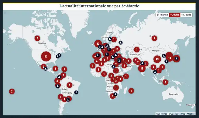
Le Monde, one of the largest French newspapers, relaunched their online paid edition with interactive French maps powered by OpenStreetMap. Read more on the MapBox blog
|
|
|
Week 17
(22–28 Apr2025-04-22–Error: Invalid time.)
|
|
|
Week 18
(29 Apr – 5 May2025-04-29–Error: Invalid time.)
|

|
|
Week 19
(6–12 May2025-05-06–Error: Invalid time.)
|
|
| English
|
"iD" is a new web-based OpenStreetMap editor which is coming out of testing into prime-time on the OpenStreetMap homepage this week. read more on the blog
|
|
|
Week 20
(13–19 May2025-05-13–Error: Invalid time.)
|
|
|
Week 21
(20–26 May2025-05-20–Error: Invalid time.)
|

|
| English
|
Canoe Mapping in the mangroves. La Boquilla, Cartagena, Colombia. In a diary entry by Humberto Yances he describes his participatory mapping project involving the local community, fishermen and ecotourism associations. Follow-up workshops resulted in a map, and ongoing work on "Social Innovation for Mangrove Conservation"
|
|
|
Week 22
(27 May – 2 Jun2025-05-27–Error: Invalid time.)
|

|
|
Week 23
(3–9 Jun2025-06-03–Error: Invalid time.)
|

|
| English
|
Comenius Mapping Party in Romania. Persons from left to right: Dario (Portugal), Pia (Slovenia), Yaren (Turkey), Mateja (Slovenia), Hilal (Turkey), Nils (Germany).
|
|
|
Week 24
(10–16 Jun2025-06-10–Error: Invalid time.)
|

|
|
Week 25
(17–23 Jun2025-06-17–Error: Invalid time.)
|

|
| English
|
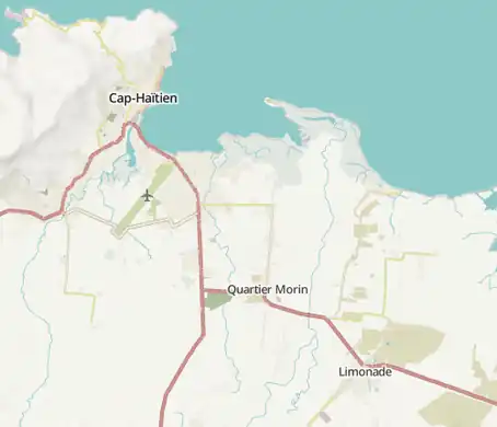
Severin Menard is conducting a workshop on QGIS as a part of HOT's "Engaging the Youth to Map The Northern Corridor" in Limonade, Haiti
|
|
|
Week 26
(24–30 Jun2025-06-24–Error: Invalid time.)
|
|
| English
|
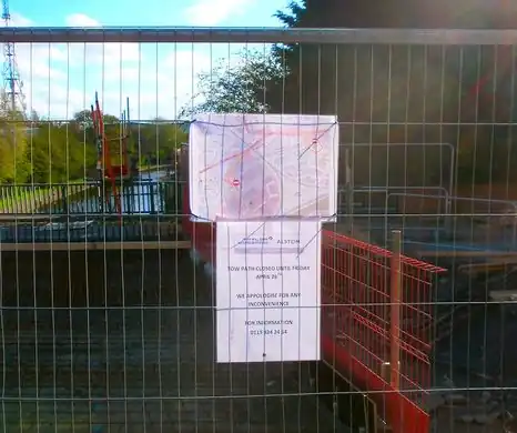
UK construction firms have access to very detailed Ordnance Survey map products, but when it comes to displaying a map on a public notice, the people building the new tram in Nottingham found it easier to use OpenStreetMap. Detailed, up-to-date, and open licensed.
|
|
|
Week 27
(1–7 Jul2025-07-01–Error: Invalid time.)
|

|
| English
|
No volcanic eruptions, no wildfires, but burning passion of OpenStreetMap volunteers – represented by a map showing the colourised node density of OpenStreetMap data. Alternative views: full world as slippy map, full world as single image (67 Mpx, 1 MiB); full world scaled down, more info how this was created.
|
|
|
Week 28
(8–14 Jul2025-07-08–Error: Invalid time.)
|
|
| English
|
A modified 'standard' view of OpenStreetMap to reveal coverage worldwide on low zoom levels. Those (0–8) have essentially been created from scaling down tiles (slightly modified and without labels) of zoom level 9 and adding the labels afterwards. This experiment by Frederik Ramm can be viewed as a zoomable map (comparison via “+” on the right); more details of the technical approach.
|
|
|
Week 29
(15–21 Jul2025-07-15–Error: Invalid time.)
|
|
| English
|
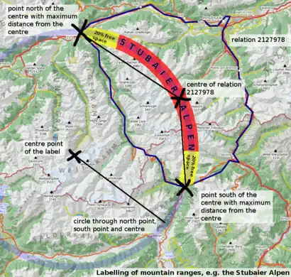
Large curved labels on a mountain range (Stubaier Alpen Stubaier Alpen shown here). The diagram illustrates how this cartographic effect could be achieved in an automated rendering process based on OpenStreetMap's raw geospatial data. Shown position on a slippy map, process description. Stubaier Alpen shown here). The diagram illustrates how this cartographic effect could be achieved in an automated rendering process based on OpenStreetMap's raw geospatial data. Shown position on a slippy map, process description.
|
|
|
Week 30
(22–28 Jul2025-07-22–Error: Invalid time.)
|

|
|
Week 31
(29 Jul – 4 Aug2025-07-29–Error: Invalid time.)
|

|
|
Week 32
(5–11 Aug2025-08-05–Error: Invalid time.)
|
|
|
Week 33
(12–18 Aug2025-08-12–Error: Invalid time.)
|

|
|
Week 34
(19–25 Aug2025-08-19–Error: Invalid time.)
|

|
| English
|
Mappers, users and developers from Baltic States, Russia, Finland and other countries gathered at the SOTM Baltics 2013 OSM local conference in Tartu, Estonia
|
|
|
Week 35
(26 Aug – 1 Sep2025-08-26–Error: Invalid time.)
|
|
| English
|
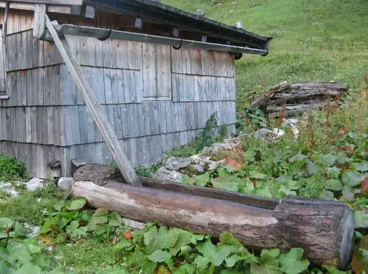
While out mapping the world OSM mappers come across some curious things. Shown here: a wooden trough fed by water from the rain gutter of a hut. Possibly it is a watering place for animals.
|
|
|
Week 36
(2–8 Sep2025-09-02–Error: Invalid time.)
|

|
|
Week 37
(9–15 Sep2025-09-09–Error: Invalid time.)
|

|
| English
|
State Of The Map 2013, the annual OpenStreetMap conference, was held in Birmingham, England, from 6th to 8th September 2013.
|
|
|
Week 38
(16–22 Sep2025-09-16–Error: Invalid time.)
|
|
|
Week 39
(23–29 Sep2025-09-23–Error: Invalid time.)
|

|
| English
|
The TIGER Battlegrid map shows colourful grid squares (orange for urban, green for countryside) for parts of the U.S. where more TIGER fixup work is needed by comparing with the newer TIGER 2012 data. Read more on this blog post
|
|
|
Week 40
(30 Sep – 6 Oct2025-09-30–Error: Invalid time.)
|
|
| English
|
The new "Humanitarian" style (also available on osm.org) offers a new window on OpenStreetMap data. This new style focuses on the needs of the HOT work, for example water and sanitation, road quality, fire hydrants, electricity network, street lights, or social facilities.
|
|
|
Week 41
(7–13 Oct2025-10-07–Error: Invalid time.)
|
|
| English
|
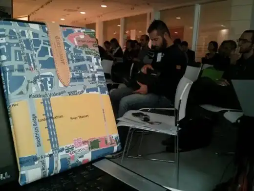
A leather iPad cover with an OpenStreetMap design on show at OSMit conference last weekend. The creators dressmap.it have more pictures on their site
|
|
|
Week 42
(14–20 Oct2025-10-14–Error: Invalid time.)
|

|
|
Week 43
(21–27 Oct2025-10-21–Error: Invalid time.)
|
|
|
Week 44
(28 Oct – 3 Nov2025-10-28–Error: Invalid time.)
|
|
| English
|
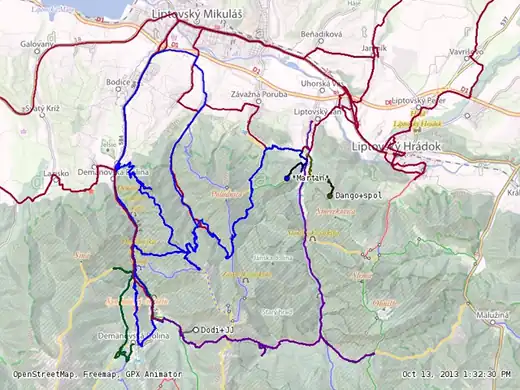
A mapping party in Low Tatras (Slovakia) took place on 12th and 13th October 2013 whose main objective was to add missing hiking and bicycle trails to the OSM data. The video shows a time-lapse animation of the participants' GPS traces.
|
|
|
Week 45
(4–10 Nov2025-11-04–Error: Invalid time.)
|
|
|
Week 46
(11–17 Nov2025-11-11–Error: Invalid time.)
|
|
| English
|
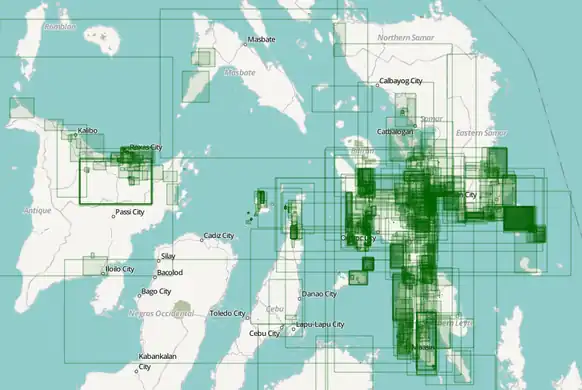
Typhoon Haiyan editing activity visualised. Pascal Neis analysed changesets in the Philippines and Vietnam. In his blog post he reports that we had contributions from 245 different people by Sunday evening, all helping to improve our map data which is being used by aid organisations and crisis responders. OSM contributors, thank you and keep up the good work!
|
|
|
Week 47
(18–24 Nov2025-11-18–Error: Invalid time.)
|

|
| English
|
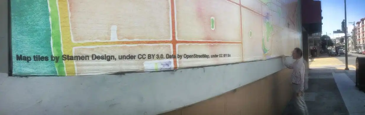
Every Line Ever in San Francisco! “OpenStreetMap: Every Line Ever, Every Point Ever” is an artistic experiment in drawing every version of every point or line feature that ever existed in the OSM database. Read more info and explore the slippy map of San Francisco or London.
|
|
|
Week 48
(25 Nov – 1 Dec2025-11-25–Error: Invalid time.)
|

|
| English
|
Large OSM-based poster maps of Tacloban, Guiuan and Ormoc printed and delivered by International Organization on Migration in DSWD Operations Center in Tacloban Airport. The maps will be used to coordinate the relief and rescue efforts for the victims/survivors of Typhoon Haiyan.
|
|
|
Week 49
(2–8 Dec2025-12-02–Error: Invalid time.)
|
|
| English
|
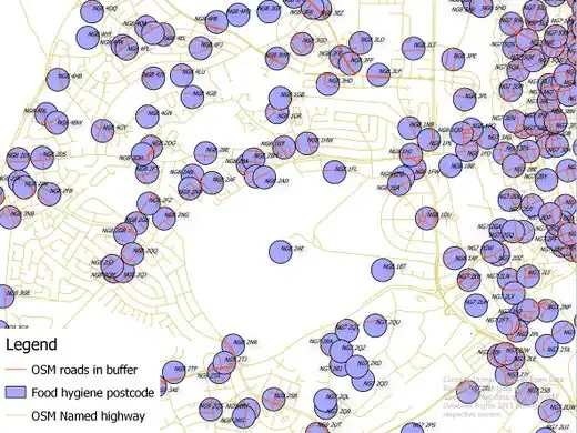
Linking UK Food Hygiene Rating System data (licensed under the Open Government License) to OSM highways. This is a potentially rich set of address and other data for OSM. Records are located to postcode centroid but contain full addresses. This image shows an intermediate step in assigning the postcodes to an individual named road. Work done at London Hack Weekend last weekend.
|
|
|
Week 50
(9–15 Dec2025-12-09–Error: Invalid time.)
|

|
| English
|
A colourful artistic map of Lille (France) with its characteristic star-shaped citadel, made using OpenStreetMap data and QGIS as described in the tutorial here.
|
|
|
Week 51
(16–22 Dec2025-12-16–Error: Invalid time.)
|
|
| English
|
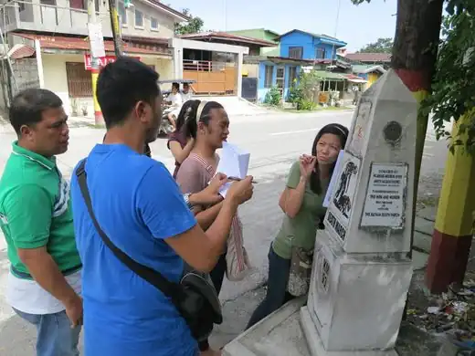
During an disaster risk reduction OSM training held November 2013 in Guagua (Pampanga, Philippines) the participants were divided into groups and did a field survey in various parts of the town. Shown in the photo is the Betis group taking down notes beside a Death March trail historical marker Death March trail historical marker. Death March trail historical marker.
|
|
|
Week 52
(23–29 Dec.)
|

|
|
