Week 1
(2–8 Jan.)
|

|
| English
|
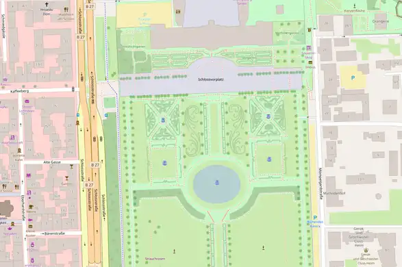
The Mable is a map table, an experimental product featuring OpenStreetMap streets laser-etched into a table top design.
|

|
|
Week 2
(9–15 Jan2025-01-09–Error: Invalid time.)
|
|
| English
|
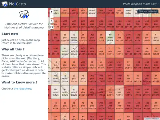
Pic4Carto helps to find useful street-level photos as a source for OpenStreetMap mapping. It shows a grid with the number of open licensed photos to be found in an area.
|
|
|
Week 3
(16–22 Jan2025-01-16–Error: Invalid time.)
|
|
|
Week 4
(23–29 Jan2025-01-23–Error: Invalid time.)
|
|
| English
|
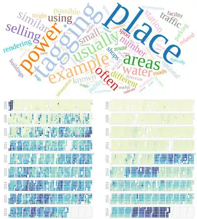
OSMvis is a collection of visualizations related to OpenStreetMap. Top: Most frequent words in the OSM Wiki. Left: Daily amount of new nodes. Right: Number of new users per day. See more visualizations at http://projects.mocnik-science.net/osm-vis/.
|
|
|
Week 5
(30 Jan – 5 Feb2025-01-30–Error: Invalid time.)
|
|
| English
|
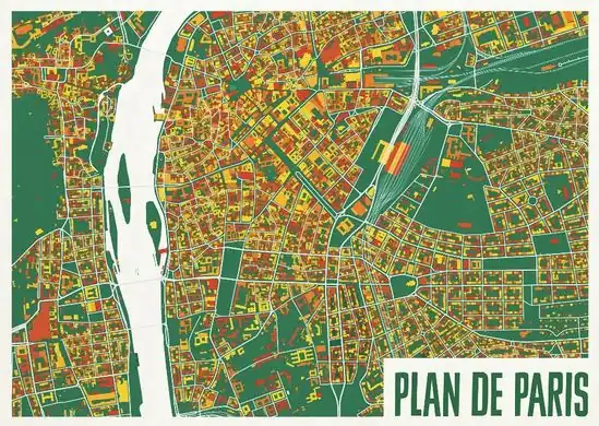
A colourful map from ateljekartan.com. A variety of interesting colour choices are available there to use for ordering poster prints.
(but can you spot the mistake in this image?)
|
|
|
Week 6
(6–12 Feb2025-02-06–Error: Invalid time.)
|
|
|
Week 7
(13–19 Feb2025-02-13–Error: Invalid time.)
|
|
| English
|
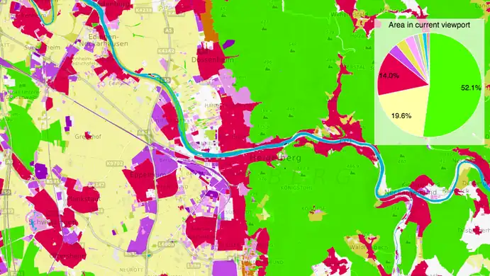
OSMLanduse.org highlights OpenStreetMap's rich landuse/landcover data. The strikingly colourful map shows how our wide range of landcover tags can be broadly classified and analysed.
|
|
|
Week 8
(20–26 Feb2025-02-20–Error: Invalid time.)
|

|
| English
|
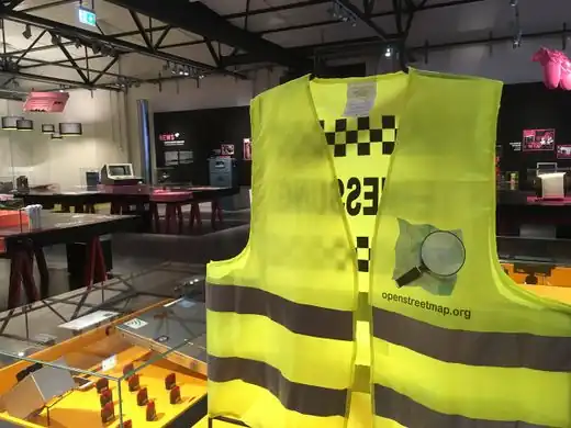
OSM Mapathon at OpenLabs Albania, a hackerspace in the city of Tirana that are organizing a lot of activities related to OpenStreetMap, Wikipedia and FLOSS. In that mapathon they used FieldPapers.
|
|
|
Week 9
(27 Feb – 5 Mar2025-02-27–Error: Invalid time.)
|
|
| English
|
Lauri Vanhala took OpenStreetMap buildings in Helsinki, analysed the location of jobs and travel times from every building, and produced this map to help decide the best place to live. Browse the full map and read more on this blog.
|
|
|
Week 10
(6–12 Mar2025-03-06–Error: Invalid time.)
|

|
|
Week 11
(13–19 Mar2025-03-13–Error: Invalid time.)
|
|
| English
|
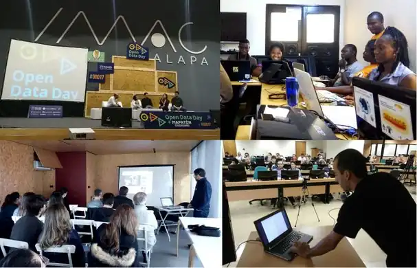
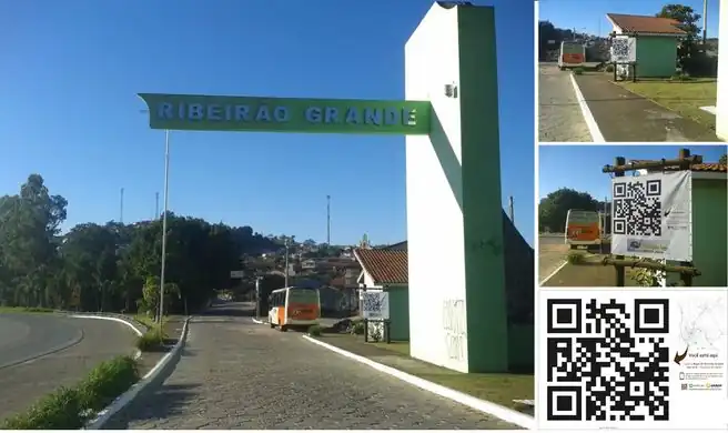
March 4th was OpenDataDay and people all over the world organized small events to talk about and produce Open Data. In a lot of places we had OpenStreetMap activities, like mapping parties, mapathons and talks. Here you can see events in Xalapa (Mexico), Cotonou (Benin), Porto (Portugal) and Brasília (Brazil).
|
|
|
Week 12
(20–26 Mar2025-03-20–Error: Invalid time.)
|
|
| English
|
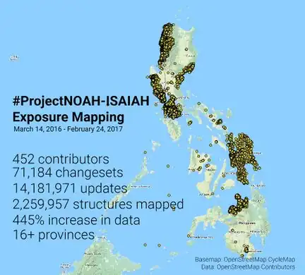
The Nationwide Operational Assessment of Hazards (NOAH) coordinated a series of mapping sessions in the last 12 months that improved the map of Philippines. This data will be used in improving disaster management before, during, and after emergencies. Read more on the NOAH blog.
|
|
|
Week 13
(27 Mar – 2 Apr2025-03-27–Error: Invalid time.)
|
|
| English
|
FOSSGIS 2017, the German OpenStreetMap and open source GIS conference, took place last week in Passau.
|
|
|
Week 14
(3–9 Apr2025-04-03–Error: Invalid time.)
|
|
| English
|
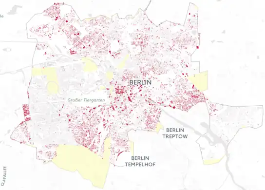
Illustrating the scale of destruction in Aleppo, Syria, by reprojecting it onto OpenStreetMap buildings of Berlin: hanshack.com.
|
|
|
Week 15
(10–16 Apr2025-04-10–Error: Invalid time.)
|
|
|
Week 16
(17–23 Apr2025-04-17–Error: Invalid time.)
|
|
| English
|
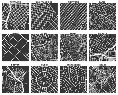
Geoff Boeing created OSMnx, a tool which uses OSM data to compare street networks and urban forms. In the image you can see one square mile extracts of some city centers around the world. Read more about Geoff's work on his blog.
|
|
|
Week 17
(24–30 Apr2025-04-24–Error: Invalid time.)
|
|
|
Week 18
(1–7 May2025-05-01–Error: Invalid time.)
|

|
| English
|
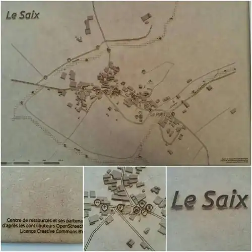
Kartegraphik has been doing handmade papercut maps based on OpenStreetMap data. This image is a map of Monterey, California. See more at kartegraphik.com.
|
|
|
Week 19
(8–14 May2025-05-08–Error: Invalid time.)
|
|
| English
|
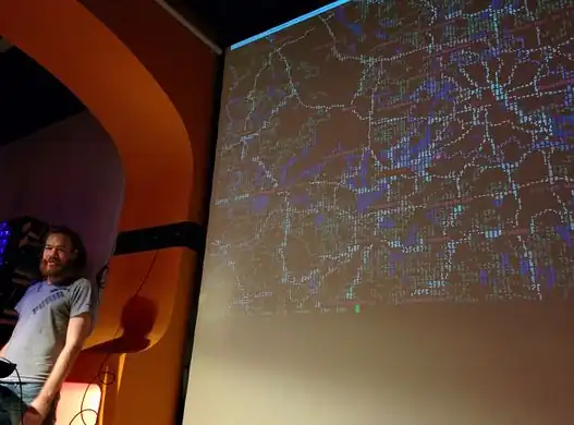
A presentation of mapscii [2], a zooming panning view of OpenStreetMap rendered as ASCII art (also including Braille dot patterns).
|
|
|
Week 20
(15–21 May2025-05-15–Error: Invalid time.)
|

|
| English
|
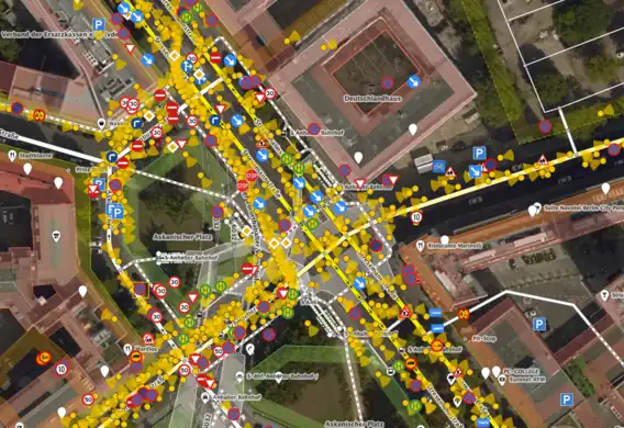
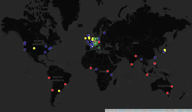
The top ten mappers (yellow) account for most of the data contributed in London so far in 2017. Andy Allan presented "Who is mapping London?" at the recent OSM Q&A event.
|
|
|
Week 21
(22–28 May2025-05-22–Error: Invalid time.)
|
|
| English
|
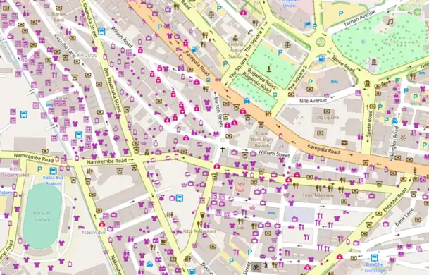
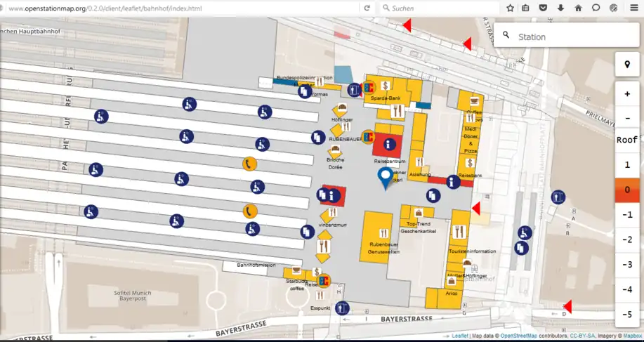
Large railway stations often include shops and other features inside them. OpenStationMap (openstationmap.org) reveals indoor mapping data (where it has been added) specifically for railway stations.
|
|
|
Week 22
(29 May – 4 Jun2025-05-29–Error: Invalid time.)
|
|
|
Week 23
(5–11 Jun2025-06-05–Error: Invalid time.)
|
.jpg)
|
| English
|
Mapathons can be made more fun and interesting when your work is displayed on a wall of monitors for everyone to see! This mapathon, supported by the OSM Philippines community, was organized by User:GOwin as part of his MapAmore initiative and was hosted by the City of San Juan's Central Emergency and Disaster Operations Center (CEDOC).
|
|
|
Week 24
(12–18 Jun2025-06-12–Error: Invalid time.)
|

|
|
Week 25
(19–25 Jun2025-06-19–Error: Invalid time.)
|
|
| English
|
The iD editor showing a new data layer from Mapillary, with road signs detected within the street-level imagery.
|
|
|
Week 26
(26 Jun – 2 Jul2025-06-26–Error: Invalid time.)
|
|
| English
|
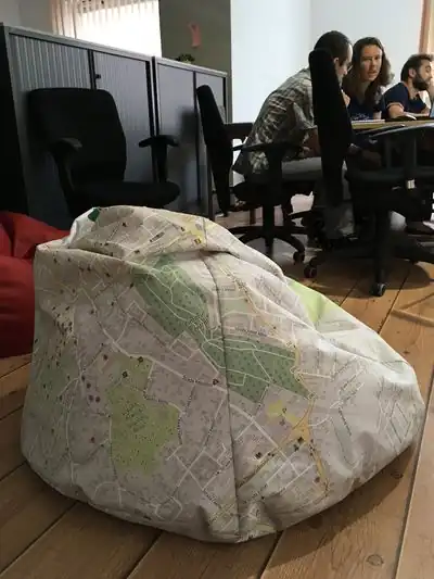
OpenStreetMap on a beanbag in the Telenav office in Cluj, Romania.
|
|
|
Week 27
(3–9 Jul2025-07-03–Error: Invalid time.)
|
|
| English
|
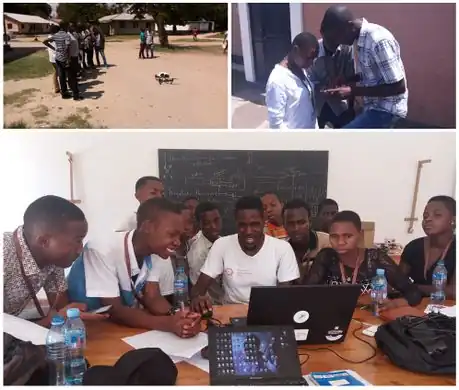
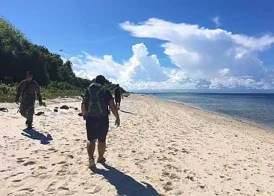
With drone pilots, Marines, Navy and Army's Scout Rangers, User:Schadow1 organised a mapping expedition in southern Philippines for logistics, navigation, military operations purposes, and tourism. 1,957 data elements were added by the expedition.
|
|
|
Week 28
(10–16 Jul2025-07-10–Error: Invalid time.)
|
|
|
Week 29
(17–23 Jul2025-07-17–Error: Invalid time.)
|

|
|
Week 30
(24–30 Jul2025-07-24–Error: Invalid time.)
|
|
| English
|
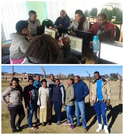
Mzwandile Thokoane from the MapLesotho project, lead a mapping event to bring advanced JOSM mapping back to Hlotse, in Leribe, Lesotho.
|
|
|
Week 31
(31 Jul – 6 Aug2025-07-31–Error: Invalid time.)
|

|
| English
|
Spotted wheeling the streets of Dresden, Germany, this tricycle has a localised OpenStreetMap design!
|
|
|
Week 32
(7–13 Aug2025-08-07–Error: Invalid time.)
|
|
| English
|
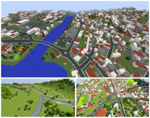
OpenStreetMap data can be represented in the 3D blocky virtual world of Minecraft. See Minecraft for a list of projects to make this conversion. These scenes were created by WorldBloxer.
|
|
|
Week 33
(14–20 Aug2025-08-14–Error: Invalid time.)
|
|
| English
|
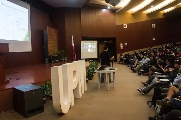
Presenting OpenStreetMap and GPS mapping to an audience of over 100 mountaineers at AkyatCon2.0, the conference of the University of Philippines Mountaineers (UPM).
|
|
|
Week 34
(21–27 Aug2025-08-21–Error: Invalid time.)
|

|
| English
|
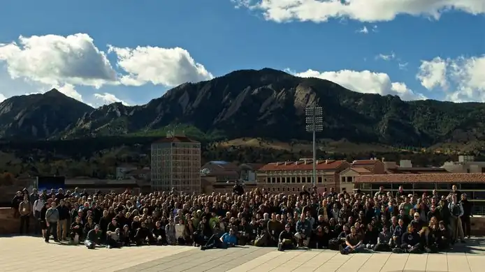
The international OpenStreetMap conference State Of The Map 2017 took place last weekend in Aizu-Wakamatsu, Japan.
|
|
|
Week 35
(28 Aug – 3 Sep2025-08-28–Error: Invalid time.)
|
|
|
Week 36
(4–10 Sep2025-09-04–Error: Invalid time.)
|

|
| English
|
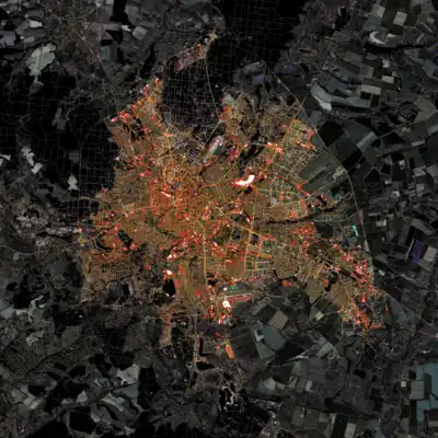
A research article by Christopher Barrington-Leigh and Adam Millard-Ball has undertaken worldwide completeness analysis of OpenStreetMap's road coverage based on visual comparison of imagery and other statistical methods.
|
|
|
Week 37
(11–17 Sep2025-09-11–Error: Invalid time.)
|

|
|
Week 38
(18–24 Sep2025-09-18–Error: Invalid time.)
|

|
| English
|
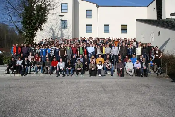
Student group photo at the end of “CartoCamp” at Université de Ségou, Mali.
|
|
|
Week 39
(25 Sep – 1 Oct2025-09-25–Error: Invalid time.)
|
|
| English
|
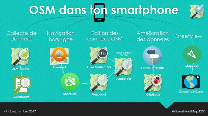
A selection of Android apps for different types of OpenStreetMap contribution and use, presented by Claire Halleux at a recent mapathon in Kinshasa.
|
|
|
Week 40
(2–8 Oct2025-10-02–Error: Invalid time.)
|

|
| English
|
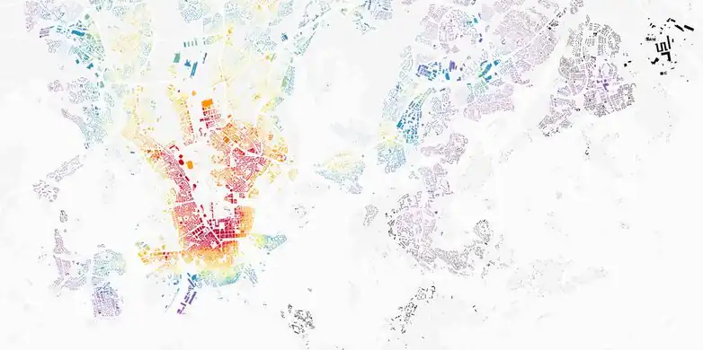
An automatically generated spectrum of urban development patterns for around 1 million cities, towns and villages across the planet. Image from Vahid Moosavi's paper “Urban morphology meets deep learning” (PDF).
|
|
|
Week 41
(9–15 Oct2025-10-09–Error: Invalid time.)
|
|
|
Week 42
(16–22 Oct2025-10-16–Error: Invalid time.)
|
|
| English
|
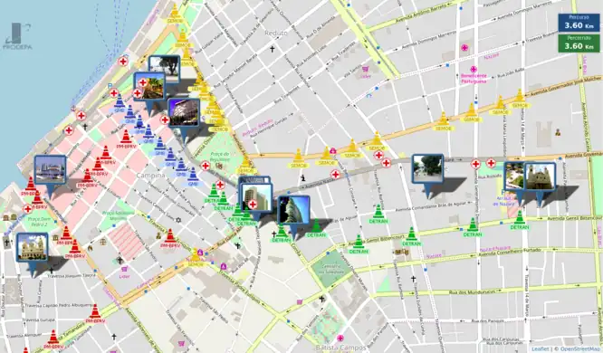
The PRODEPA state agency created an online map of the city of Belém, State of Pará, Brazil, showing the location of a dozen of processions, and of points of interest, temporary medical facilities and blocked streets, for the “Círio de Nazaré” religious festival, gathering more than 2 million people during 2 weeks in October 2017.
|
|
|
Week 43
(23–29 Oct2025-10-23–Error: Invalid time.)
|
|
|
Week 44
(30 Oct – 5 Nov2025-10-30–Error: Invalid time.)
|
|
| English
|
Gontsa is creating a series of images merging OpenStreetMap data on top of Landsat satellite imagery. This image shows Kharkiv, Ukraine, during the autumn. You can see other works of Gontsa on his Instagram page.
|
|
|
Week 45
(6–12 Nov2025-11-06–Error: Invalid time.)
|

|
| English
|
An award given to the (Swiss) OpenStreetMap longterm contributors, presented at the DINAcon 2017 conference in Bern on digital sustainability.
|
|
|
Week 46
(13–19 Nov2025-11-13–Error: Invalid time.)
|
|
| English
|
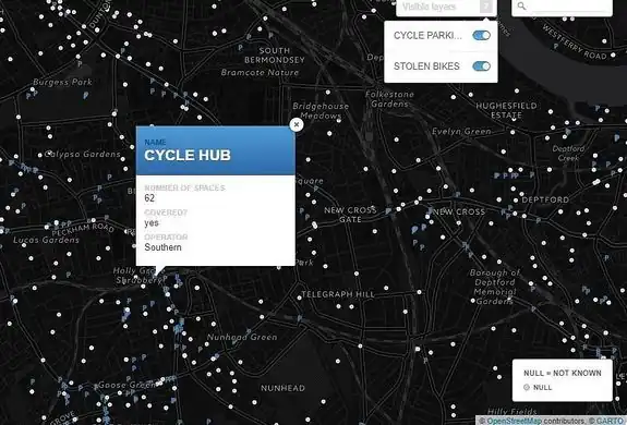
A map made by Stolen Ride shows every London cycle parking location mapped on OpenStreetMap and an optional layer of police data with the places of reported stolen bikes.
|
|
|
Week 47
(20–26 Nov2025-11-20–Error: Invalid time.)
|
|
|
Week 48
(27 Nov – 3 Dec2025-11-27–Error: Invalid time.)
|
|
|
Week 49
(4–10 Dec2025-12-04–Error: Invalid time.)
|
|
| English
|
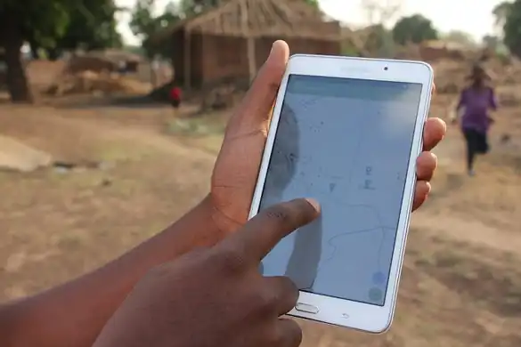
Missing Maps data being used in a flood preparedness mission in Malawi, by the Malawi Red Cross Society and the Netherlands Red Cross. Information (building=*) on building quality and materials is added to OpenStreetMap to facilitate an efficient future aid response.
|
|
|
Week 50
(11–17 Dec2025-12-11–Error: Invalid time.)
|
|
| English
|
Richard Folly visiting Fatima Alher and the OSMGirls, a multilingual mapping group of young African women (based in Comoros, Côte d'Ivoire, France, Ghana, Madagascar, Malawi, Mozambique, Niger, South Africa, Tanzania, Togo and Uganda).
|
|
|
Week 51
(18–24 Dec2025-12-18–Error: Invalid time.)
|
|
| English
|
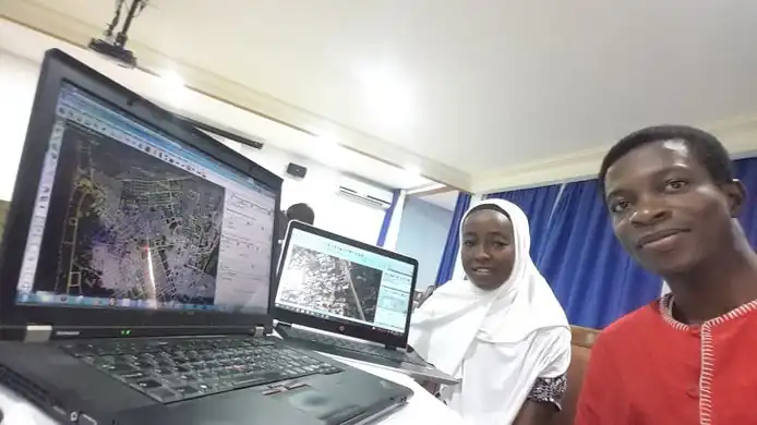
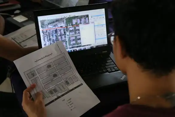
Regular mapping event “Mapping Yangon” at Phandeeyar Myanmar Innovation Lab added on OpenStreetMap the street names, health centers and public locations of Dala township, Yangon region, Myanmar.
|
|
|
Week 52
(25–31 Dec.)
|
|
| English
|
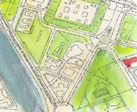
Detail from a watercolour map of Seville, created by Andrew McGuire as a Christmas present for his wife. Hand-painted upon an OpenStreetMap base-map via Mapzen.
|
|
|
