Week 1
(4–10 Jan.)
|

|
|
Week 2
(11–17 Jan2025-01-11–Error: Invalid time.)
|
|
| English
|
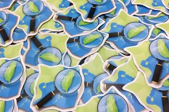
Stickers of OpenStreetMap Taiwan logo for Participants of the Kaohsiung Meetup, which occurred in the Southern port city in Taiwan.
|

|
|
Week 3
(18–24 Jan2025-01-18–Error: Invalid time.)
|
.jpg)
|
| English
|
OpenStreetMap in an IC2 carriage (Deutsche Bahn). The map shows the current location of the train and highlights the stations.
|
|
|
Week 4
(25–31 Jan2025-01-25–Error: Invalid time.)
|
|
| English
|
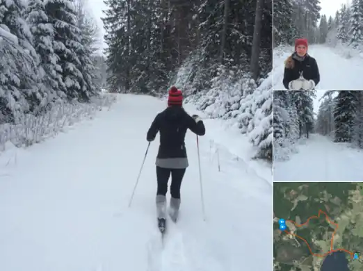
“We won‘t let the snow stop us!” The folks at swedish design firm geoshepherds, have been out mapping on their cross-country skis!
|
|
|
Week 5
(1–7 Feb2025-02-01–Error: Invalid time.)
|
|
|
Week 6
(8–14 Feb2025-02-08–Error: Invalid time.)
|
|
| English
|
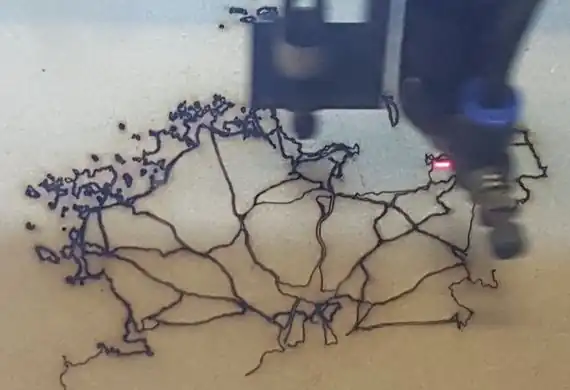
The FabLab Lannion laser cutting machine, making a map of the roads of Lannion-Tregor Communauté, northern France (here).
|
|
|
Week 7
(15–21 Feb2025-02-15–Error: Invalid time.)
|

|
| English
|
SmellyMaps. Mapping different types of smell (based on flickr tags & tweets) as different colours on the OpenStreetMap road network.
|
|
|
Week 8
(22–28 Feb2025-02-22–Error: Invalid time.)
|
|
| English
|
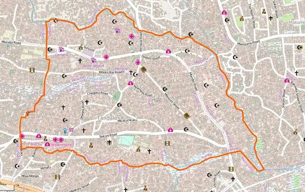
Tandale in Dar Es Salaam, Tanzania, has been mapped in dense detail since 2009. Recently the Ramani Huria project involved local people and UAV imagery, updating reflecting flood changes, and adding even more local details (see the mapsee the map).
|
|
|
Week 9
(1–6 Mar2025-03-01–Error: Invalid time.)
|

|
| English
|
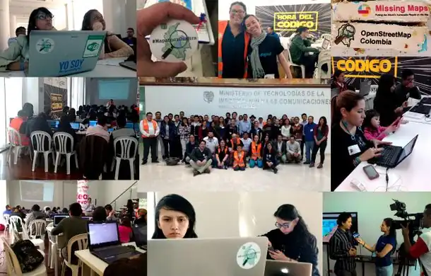
The Philippine Red Cross (PRC) and the Croix-Rouge Française hosted a 3-day OpenStreetMap workshop in Bogo, Cebu, as part of their Northern Cebu Risk Mapping project. Read more here.
|
|
|
Week 10
(7–13 Mar2025-03-07–Error: Invalid time.)
|

|
| English
|
Conference organised by the Mexico OpenStreetMap community in the campus of the Universidad Autónoma del Estado de México in Toluca.
|
|
|
Week 11
(14–20 Mar2025-03-14–Error: Invalid time.)
|
|
|
Week 12
(21–27 Mar2025-03-21–Error: Invalid time.)
|
|
| English
|
For OpenDataDay 2016 in Santiago, Chile they asked passers-by in a public square to put sticky notes over a big printed OpenStreetMap map. Read more on this OKFN blog post.
|
|
|
Week 13
(28 Mar – 3 Apr2025-03-28–Error: Invalid time.)
|
|
| English
|
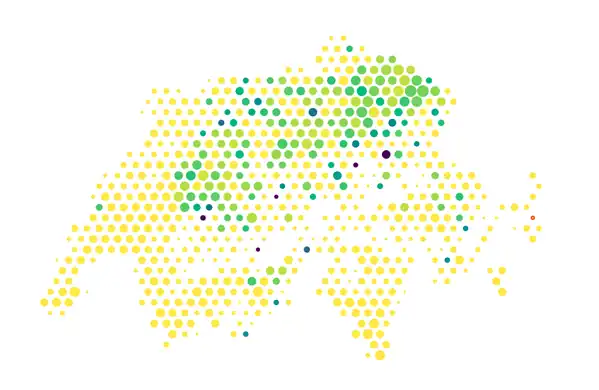
Distribution of place names containing “berg” (German for “mountain”) in Switzerland. Try out your own place names query to visualise geographic distribution using Chris Roth’s Places tool.
|
|
|
Week 14
(4–10 Apr2025-04-04–Error: Invalid time.)
|
|
| English
|
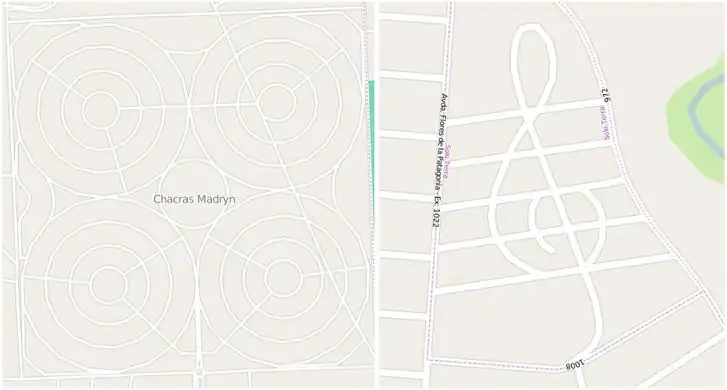
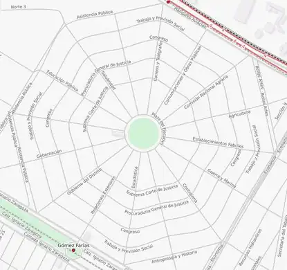
Argentina has some curious street layouts. In the city of Puerto Madryn there is a suburb with concentric circular streets and in El Calafate a suburb (Solo Terra) whose streets form a treble clef!
|
|
|
Week 15
(11–17 Apr2025-04-11–Error: Invalid time.)
|

|
| English
|
India has 22 languages and one of the powerful features of OpenStreetMap is that we can map places and feature names in more than one language. User PlaneMad has created a view of this data. A multilingual map of India. Read more on his diary entry.
|
|
|
Week 16
(18–24 Apr2025-04-18–Error: Invalid time.)
|
|
| English
|
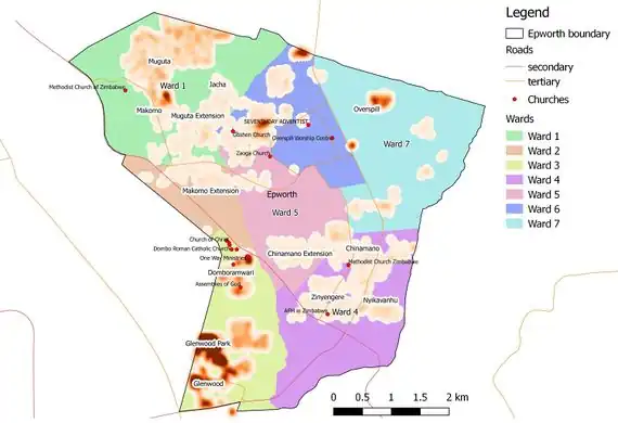
Heatmap of addresses across Epworth, in Harare Province, Zimbabwe. An example of planning and reporting efforts needed to create or improve Missing Maps in Africa.
|
|
|
Week 17
(25 Apr – 1 May2025-04-25–Error: Invalid time.)
|

|
| English
|
Colombian mapper Fredy Rivera likes to take his 4x4 and map mountain trails for OpenStreetMap. With such stunning scenery in the Andes, who can blame him?! Fredy was featured in this mapper in the spotlight blog post.
|
|
|
Week 18
(2–8 May2025-05-02–Error: Invalid time.)
|
|
|
Week 19
(9–15 May2025-05-09–Error: Invalid time.)
|
|
| English
|
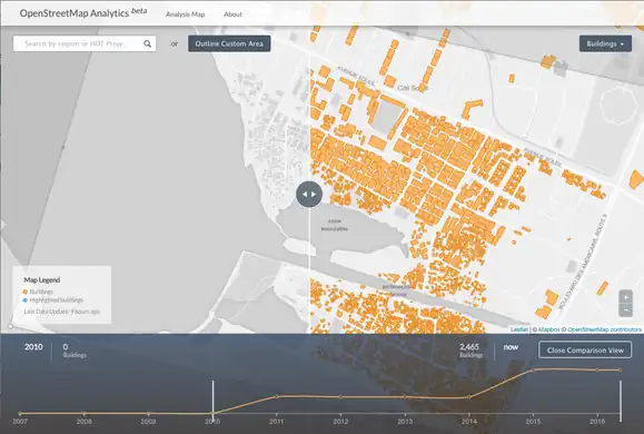
The new OSM Analytics tool showing progress with mapping buildings in Haiti, by comparing on a timeline, and with a visual side-by-side map slider.
|
|
|
Week 20
(16–22 May2025-05-16–Error: Invalid time.)
|

|
|
Week 21
(23–29 May2025-05-23–Error: Invalid time.)
|
|
|
Week 22
(30 May – 5 Jun2025-05-30–Error: Invalid time.)
|
|
|
Week 23
(6–12 Jun2025-06-06–Error: Invalid time.)
|
|
|
Week 24
(13–19 Jun2025-06-13–Error: Invalid time.)
|
|
| English
|
Members of Swiss OSM (SOSM) shared a stand at Geosummit in Bern. Demonstrations included "Map on a Stick" and a variety of printed maps based on OSM. Swiss Federal Councillor & Minister for Defence and Sports, Guy Parmelin, is discussing the mapping of his home town of Bursins with prof. Stefan Keller (HSR, Rapperswil).
|
|
|
Week 25
(20–26 Jun2025-06-20–Error: Invalid time.)
|

|
| English
|
A bus map produced with OpenStreetMap, is now being used and enjoyed by the people of Managua, Nicaragua. This article tells the story.
|
|
|
Week 26
(27 Jun – 3 Jul2025-06-27–Error: Invalid time.)
|

|
| English
|
Presented at OSMit2016, this moving 3D model by OpenDot Lab is the latest way to visualise OpenStreetMap stats! Watch a video here.
|
|
|
Week 27
(4–10 Jul2025-07-04–Error: Invalid time.)
|
|
| English
|
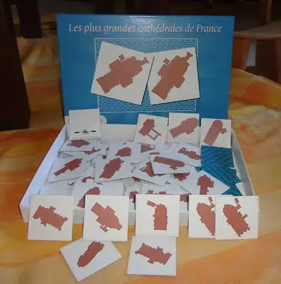
Board game using OSM data: memory game of the French largest cathedrals. JBacc created this by filtering of the Geofabrik extract with Osmosis, area calculation with QGIS, data processing and rendering with Maperitive/Maperipy.
|
|
|
Week 28
(11–17 Jul2025-07-11–Error: Invalid time.)
|
|
| English
|
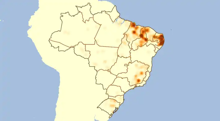
Luc Freitas analysed mapping progress of Brazilian cities (diary entry in Portuguese). He looked at the size of cities based on municipal boundaries data (already imported from IBGE), and correlated this with the amount of residential roads data in OpenStreetMap. This image and the tabular output helps guide further mapping efforts by the Brazilian community.
|
|
|
Week 29
(18–24 Jul2025-07-18–Error: Invalid time.)
|

|
| English
|
Throughout June there was a big series of MapLesotho mapping events (involving modem equipment travelling around the country!), culminating in this final mapping session with a visit from the Lesotho minister for local government. Read more on the MapLesotho blog.
|
|
|
Week 30
(25–31 Jul2025-07-25–Error: Invalid time.)
|

|
| English
|
State Of The Map U.S. 2016 took place last weekend in Seattle with a packed program of talks, workshops, hacking & mapping.
|
|
|
Week 31
(1–7 Aug2025-08-01–Error: Invalid time.)
|
|
| English
|
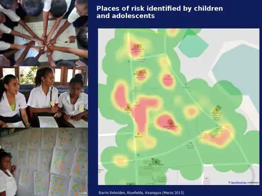
In Bluefields, Nicaragua, the local OSM community and UNICEF worked with school children to help them empower themselves through the use of maps.
|
|
|
Week 32
(8–14 Aug2025-08-08–Error: Invalid time.)
|

|
| English
|
OpenStreetMap spotted on board a bus in Kraków, Poland.
|
|
|
Week 33
(15–21 Aug2025-08-15–Error: Invalid time.)
|

|
|
Week 34
(22–28 Aug2025-08-22–Error: Invalid time.)
|
|
| English
|
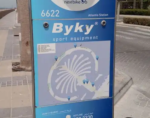
The ByKy bike share system in Dubai (UAE) has signposts at each docking station, featuring OpenStreetMap!
|
|
|
Week 35
(29 Aug – 4 Sep2025-08-29–Error: Invalid time.)
|

|
|
Week 36
(5–11 Sep2025-09-05–Error: Invalid time.)
|
|
|
Week 37
(12–18 Sep2025-09-12–Error: Invalid time.)
|
|
|
Week 38
(19–25 Sep2025-09-19–Error: Invalid time.)
|

|
|
Week 39
(26 Sep – 2 Oct2025-09-26–Error: Invalid time.)
|
|
|
Week 40
(3–9 Oct2025-10-03–Error: Invalid time.)
|
|
|
Week 41
(10–16 Oct2025-10-10–Error: Invalid time.)
|
|
| English
|
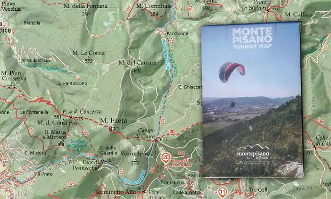
Marco Barbieri presented his cartographic work at OSMit last year, producing these attractive web maps (webmapp.it) and printable tourist maps of Monte Pisano, as well as organising mapping parties in this part of Italy.
|
|
|
Week 42
(17–23 Oct2025-10-17–Error: Invalid time.)
|

|
|
Week 43
(24–30 Oct2025-10-24–Error: Invalid time.)
|
|
| English
|
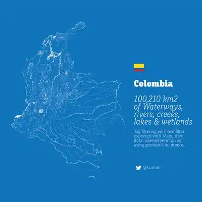
A beautiful image showing all the rivers, lakes, creeks and wetlands of Colombia by Omar Pineda.
|
|
|
Week 44
(31 Oct – 6 Nov2025-10-31–Error: Invalid time.)
|
|
|
Week 45
(7–13 Nov2025-11-07–Error: Invalid time.)
|
|
| English
|
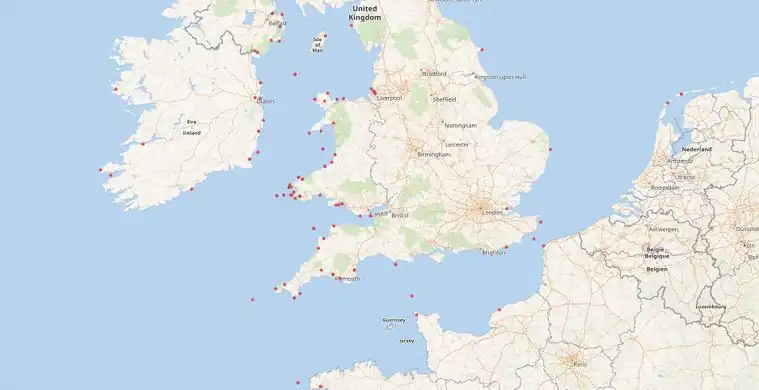
The WikiData project has an eclectic mix of linked datasets and provides a querying interface which can yield a map. This example by Jason Evans shows positions of 19th century Aberystwyth ships wrecked at sea, using data from National Library of Wales and the Ceredigion Archives.
|
|
|
Week 46
(14–20 Nov2025-11-14–Error: Invalid time.)
|

|
| English
|
Interchange Choreography by Nicholas Rougeux, is an artistic exploration of major road intersections "Applying colors to roads and using connecting roads to blend those colors".
|
|
|
Week 47
(21–27 Nov2025-11-21–Error: Invalid time.)
|

|
| English
|
Take open data from OpenStreetMap and have it turned into a stylish and unique pendant on meshu.io!
|
|
|
Week 48
(28 Nov – 4 Dec2025-11-28–Error: Invalid time.)
|
|
|
Week 49
(5–11 Dec2025-12-05–Error: Invalid time.)
|

|
|
Week 50
(12–18 Dec2025-12-12–Error: Invalid time.)
|

|
| English
|
Local volunteers trained by the American Red Cross have mapped 7,000 villages in the border regions of Liberia, Guinea, and Sierra Leone. A total of 70,000 kilometres of roads and paths, including this example, Forécariah in Guinea.
|
|
|
Week 51
(19–25 Dec2025-12-19–Error: Invalid time.)
|

|
| English
|
These stripped down maps elegantly characterise world cities by highlighting the shape of water features. They were created by Alex Szabo-Haslam and recently featured in a guardian cities quiz. How many do you recognise?
|
|
|
Week 52
(26 Dec. – 1 Jan.)
|
|
| English
|
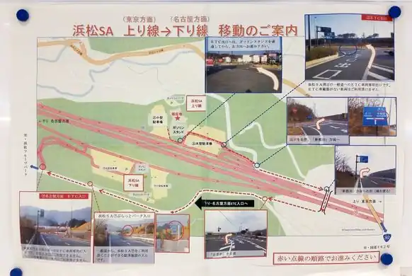
A poster about how to make a U-turn at Hamamatsu highway service area, made by the Shizuoka prefecture, Japan.
|
|
|
