Key:tactile_paving
 |
| Description |
|---|
| Indicates whether a blind or visually impaired pedestrian can detect or follow the feature using a cane. |
| Group: accessibility |
| Used on these elements |
| Documented values: 4 |
| Status: approved |
| Tools for this tag |
|
Tactile paving is a system of textured ground surface indicators found on footpaths, stairs and public transportation platforms to assist pedestrians who are blind or visually impaired. A tactile paving area has a surface that is easy to detect using a long cane, typically because it is rougher than the surrounding surface area or has an embossed pattern.
-
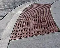
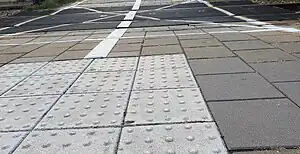
 Tactile paving on a sidewalk. Line tile means go and dot tile means attention.
 -
 Tactile paving (white) at a bus stop in Germany.
 -
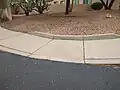
Tactile paving warning about a lowered kerb.
-
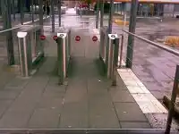
 Australian bus stop showing two different tactile patterns.
 -
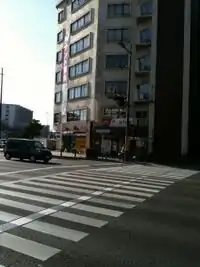 Japanese zebra crossing with tactile paving.
 -
=incorrect- The paving is not where you walk - You don't find the door. -
=incorrect- The paving is not where you walk - You run into the poles. The paving to the door is missing / there are tactile elements used for decoration. -
=primitive- A kerb cut with divots in the concrete to prevent pedestrians from slipping. -
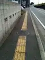
 Plastic line used on railway crossings at train stations in the Netherlands (info in Dutch).
Common values
=yes=no=contrastedWhere there is a tactile paving which contrast is at least 70% the colour of the ground (white if the ground is black and vice-versa).=primitiveWhere any water drain or decorative tactile element can be used for orientation accidentally, but no typical tactile ground elements are used.=incorrectWhere tactile paving is used but not in a sensible way, e.g. if the paving is symmetric for visual pleasure but on one of the sides it leads to nothing, or if only one sloped kerb at a crossing has tactile paving. It may be sensible if tactile paving leads to a building wall, because the way continues next to the wall and it can be used for orientation with a white cane.=partial
Note: There is no default value. =no can be tagged explicitly if discovered.
Use
Use on nodes 
In general: Use precise coordinates or add fixme=position estimated!
- For dangerous spots
- On the node of a
highway=crossing, if the tactile paving is only on one side then=incorrectis mostly used (some mappers, however, prefer the tag=partialinstead, to be more precise). - When a footway next to a road ends at a crossing with a lowered kerb (
kerb), tactile_paving is often used to indicate the dangerous spot=yes. This is set separately for each side of the road, because it can be different! Use in the same way on traffic islands. - When a bus stop is mapped as a node
highway=bus_stopand there is one or more lines of tactile_paving at that bus stop, the bus_stop node gets=yes highway=elevator, when there is a tactile paving at the entrance of an elevator ON EACH LEVEL!
- On the node of a
-
Tactile paving (white) at a bus stop in Germany. Correct use of tactile paving on node.
-
Tactile paving warning about a lowered kerb. Correct use of tactile paving on node.
-
Australian bus stop showing two different tactile patterns. Correct use of tactile paving on node.
Use on ways 
- On a pedestrian crossing
footway=crossing, when the tactile paving is used in a line all across the crossing. Do not use=*on the way when only the two spots where the footway ends are paved differently.
-
Tactile paving on a sidewalk. This is correct use of tactile paving on a way.
-
Japanese zebra crossing with tactile paving. This is correct use of tactile paving on a way.
- On footways, when there is a line all the way on the footway
highway=footway. - On platforms,
highway=platformorman_made=pier. If the platform or pier is mapped as an area, only if you draw a separate way for the tactile lines. If the platform or pier is small and mapped as a way, add=yesto the way. - Use on the way
highway=stepsof steps (some of which haveconveying=*), even if there is only a spot with tactile paving at each end.- Use
yeswhen there is tactile paving at the top and bottom of the steps. - Use
nowhen there is no tactile paving. - Use
partialif there is only tactile paving at the top (the stairs themselves are sufficient tactile objects to be detected with a cane). - Use
incorrectif there is only tactile paving at the bottom (the dangerous point is the top).
- Use
Use on areas 
=yesshould primarily be used on more precise nodes and ways, instead of areas. If you have a large area (like a market place) with indicator lines across, please draw separate ways for the tactile paving and map on ways. That being said, note that there are advantages of also tagging it on some areas, especially thin ones likehighway=platform(see community discussion)=nocan be used on border polygons to indicate that a community is not aware at all of the requirements of blind persons.
Use on relations 
=yescan be used on route/tram relations for instance, when all vehicles in use are equipped with tactile indicators at the doors or similar. Please addblind:description:en=*to tell about the details.
Typical combinations
- OSM for the blind
blind:description:en=*See DisabilityDescription.traffic_signals:sound=yes/notraffic_signals:vibration=yes/notraffic_signals:floor_vibration=yes/notraffic_signals:arrow=yes/notraffic_signals:minimap=yes/notactile_paving:colour=*- Describes the colour of the tactile pavingtactile_paving:type=*
Editing with JOSM
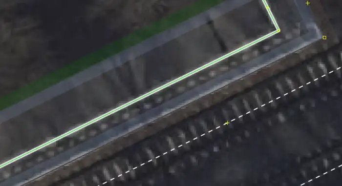
In JOSM the Map Paint Style Sidewalks and footways (with knobs on) can be used to visualize the presence of =* when used on ways ![]() :
:
Rendering
Tactile paving does not need to be rendered on visual maps by default. It will be used for tactile maps and acoustic routing software for pedestrians.
There is a visual map for features for the blind: blindmap.
- HaptoRender - Tactile OSmaps for the blind.
- LoroDux - Pedestrian navigation software for the blind
- Loadstone - GPS tool for the blind, able to import OSM POIs and crossings.