Tag:barrier=city_wall
 |
| Description |
|---|
| A fortification used to defend settlements in ancient to modern times. |
| Rendering in OSM Carto |

|
| Group: barriers |
| Used on these elements |
| Implies |
| Useful combination |
| See also |
| Status: approved |
| Tools for this tag |
|
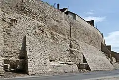
A city wall is a fortification used to defend a city or settlement from potential aggressors. In ancient to modern times, they were used to enclosing settlements.
How to map
Draw a way along the city wall and add barrier=. For wider walls, draw an area along the city wall outline and add barrier=+area=yes(or type=multipolygon for multipolygon relation).
Use historic=yes for historic city walls.
If there is a higher and a lower terrain on either side of the city wall (similar to barrier=retaining_wall), then the lower terrain (usually outside the settlement) should be on the right side of the line, relative to the drawn way direction. If there is no height difference, two_sided=yes should be added (see proposal).
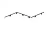
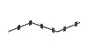
Examples with visualisation:
| Case | Drawn way | Rendering example | Tagging | Description |
|---|---|---|---|---|
| With height difference | 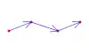
|
|
barrier=
|
There are different terrain heights to the left and right of the city wall. Behaves the same as barrier=retaining_wall: the lower side is on the right side of the way direction; marked with dots in the rendering example.
|
| Without height difference |
|
|
barrier= + two_sided=yes
|
Both sides of the city wall have the same (terrain) height; marked with dots on both sides in the rendering example. |
See also
defensive_works=*– Tags for all defensive structures found in and around fortificationshistoric=citywalls– Alternative tagging for historic city walls (rendered in OSM Carto)historic=city_gate– A gate which is or was set in a city wallhistoric=castle_wall– For walls around a castle (not for settlements)barrier=wall+wall=castle_wall– Castle walls